Voyage details and related metadata, reports, events and data.
FR 12/98
(alternative identifier: FR199812)
- is a Marine National Facility ![]() voyage
voyage
Period: 1998-10-06 00:00 to 1998-10-16 00:00 Local
Duration: 10.00 days
From: Sydney To: Sydney
Region: Tasman Sea (Lord Howe Island and adjacent region)
Ship: Franklin [details]
Description: Franklin cruise FR 12/98 was undertaken to study reef sedimentation and erosional development of volcanic islands at the southernmost latitudinal limit to reef growth in the south-west Pacific Ocean. Sampling was centred on two areas, Lord Howe Island and Middleton Reef. Sea-floor sedimment samples were collected by grab and piston cores. Seismic data were also collected and coral growth studied at Middleton Reef. Further sampling was carried out at Ball's Pyramid adjacent to Lord Howe Island. Bathymetric and current velocity data were collected throughout the voyage to provide geomorphological information and to relate to sediment distribution.
Leader: C. Woodroffe (University of Wollongong)
Project: National Facility External Users: C. Woodroffe (University of Wollongong) [details]
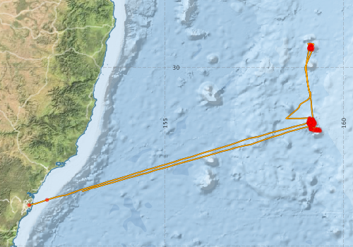
Voyage extents: 33° 51.5' S to 29° 19.9' S 151° 11.9' E to 159° 21.7' E Get voyage track shapefile Get CSV
Marlin Metadata:-
Participants - on ship:-
| Name | Role | Organisation |
|---|---|---|
| Brian Jones | Chief Investigator | University of Wollongong |
| Colin Woodroffe | Chief Investigator | University of Wollongong |
| Dave Terhell | Cruise Manager | CSIRO ORV |
| David Kennedy | University of Wollongong | |
| David Mitchell | University of Sydney | |
| Dean Hiscox | Lord Howe Island Board | |
| Eugene Wallensky | Australian National University | |
| John Marshall | Australian National University | |
| Mark Dickson | University of Wollongong | |
| Phil Adams | CSIRO ORV | |
| Stuart Fallon | Australian National University | |
| Vicki Harriott | Southern Cross University |
This list includes those that may have only been on part of the voyage. See voyage reports on 'Reports and Maps' tab for details.
Marine National Facility Reports - plans, summaries and data processing
-
FR199812 Voyage Summary
- includes preliminary results, voyage narrative, types of data collected with C77/ROSCOP codes.
-

Publications, reports and datasets from this voyage.
Journal Article
- KENNEDY, D. M.,WOODROFFE, C. D. (2004) Carbonate sediments of Elizabeth and Middleton Reefs close to the southern limits of reef growth in the southwest Pacific. Australian Journal of Earth Sciences 51 pp847-857. 10.1111/j.1400-0952.2004.01089.x
- Kennedy, D.M,Woodroffe, C.D,Jones, B.G,Dickson, M.E,Phipps, C.V.G (2002) Carbonate sedimentation on subtropical shelves around Lord Howe Island and Balls Pyramid, Southwest Pacific. Marine Geology 188 pp333-349. 10.1016/s0025-3227%2802%2900406-1
- WOODROFFE, C,DICKSON, M,BROOKE, B,KENNEDY, D (2005) Episodes of reef growth at Lord Howe Island, the southernmost reef in the southwest Pacific. Global and Planetary Change 49 pp222-237. 10.1016/j.gloplacha.2005.09.003
- Woodroffe, C., Kennedy, D., Brendan P. Brooke, & Mark E. Dickson. (2006), Geomorphological Evolution of Lord Howe Island and Carbonate Production at the Latitudinal Limit to Reef Growth. Journal of Coastal Research, 22(1), pp. 188-170. External link to reference
- Woodroffe, C.D.,Kennedy, D.M.,Jones, B.G.,Phipps, C.V.G. (2004) Geomorphology and Late Quaternary development of Middleton and Elizabeth Reefs. Coral Reefs 23 pp-. 10.1007/s00338-004-0374-1
- Woodroffe, Colin D.,Kennedy, David M.,Brooke, Brendan P.,Dickson, Mark E. (2006) Geomorphological Evolution of Lord Howe Island and Carbonate Production at the Latitudinal Limit to Reef Growth. Journal of Coastal Research 221 pp188-201. 10.2112/05a-0014.1
Search for publications, reports and datasets from this and other voyages
Data publishing
This is a list of online datasets hosted by CSIRO. Other processed datasets hosted by collaborating organisations may be found on the 'Metadata' or "Reports, Publications and Maps' tab.
Use the Get data link on the right to extract data using the NCMI Data Trawler.
| Data Stream | Data Summary | Get data | ||||||||||||||
|---|---|---|---|---|---|---|---|---|---|---|---|---|---|---|---|---|
| ADCP Data |
|
Get Data from Trawler Download ASCII dataset - fr9812adcp.zip Download NetCDF dataset fr9812adcp.zip Processing report for this dataset |
||||||||||||||
| Underway |
|
Get Data from Trawler |
Deployments by start time:- Click on column header to sort. Use link on 'Deployment' to see full details. Use the CSV button at the bottom to export data (tab delimited).
Search for deployments from this voyage and others
| Deployment | Operation | Station | Cast | Gear | Project | Start and end times | Start Location | End Location | Depth range | Max Depth | Description | |||
|---|---|---|---|---|---|---|---|---|---|---|---|---|---|---|
| Underway System [details] | Anemometer,Anemometer,Anemometer,Barometer,Gyro-MK 10,Humidity probe,RIMCO vane driving potentiometer,RIMCO vane driving potentiometer,Ships log,Simrad EA500 Echosounder,Temperature sensor-AD590J | 109 | 1998-10-06 01:05 | 1998-10-15 08:55 | -33.8580 | 151.1980 | -33.4708 | 152.6830 | ||||||
| ADCP Data [details] | RDI VM-150 Acoustic Doppler current profiler | 109 | 1998-10-06 03:40 | 1998-10-15 23:40 | -33.7120 | 151.6970 | -33.0860 | 154.0090 | 320.8 | |||||
| Sediment Sampling [details] | G20 | -29.4412 | 159.0704 | 43 | ||||||||||
| Sediment Sampling [details] | G21 | -29.4247 | 159.0678 | 53.5 | ||||||||||
| Sediment Sampling [details] | G22 | -29.4321 | 159.0562 | 51.5 | ||||||||||
| Sediment Sampling [details] | G23 | -29.4377 | 159.0460 | 61.5 | ||||||||||
| Sediment Sampling [details] | G24 | -29.4171 | 159.0829 | 42.5 | ||||||||||
| Sediment Sampling [details] | G25 | -29.4177 | 159.0844 | 33.5 | ||||||||||
| Sediment Sampling [details] | G26 | -29.4339 | 159.0844 | 32 | ||||||||||
| Sediment Sampling [details] | G27 | -29.4168 | 159.0666 | 66.5 | ||||||||||
| Sediment Sampling [details] | G28 | -29.4200 | 159.0473 | 298 | ||||||||||
| Sediment Sampling [details] | G29 | -29.4008 | 159.0729 | 273.5 | ||||||||||
| Sediment Sampling [details] | G30 | -29.4000 | 159.0862 | 167 | ||||||||||
| Sediment Sampling [details] | G31 | -29.4005 | 159.1034 | 121 | ||||||||||
| Sediment Sampling [details] | G32 | -29.3990 | 159.1118 | 367.5 | ||||||||||
| Sediment Sampling [details] | G33 | -29.3628 | 159.0646 | 1312 | ||||||||||
| Sediment Sampling [details] | G34 | -29.4575 | 159.0284 | 90.5 | ||||||||||
| Sediment Sampling [details] | G35 | -29.4786 | 159.0308 | 139 | ||||||||||
| Sediment Sampling [details] | G36 | -29.5000 | 159.0572 | 254 | ||||||||||
| Sediment Sampling [details] | G37 | -29.4992 | 159.0873 | 117.5 | ||||||||||
| Sediment Sampling [details] | G38 | -29.5028 | 159.1236 | 295 | ||||||||||
| Sediment Sampling [details] | PC3 | -29.4306 | 159.0653 | 49 | ||||||||||
| Sediment Sampling [details] | PC4 | -29.4274 | 159.0583 | 54 | ||||||||||
| Sediment Sampling [details] | PC5 | |||||||||||||
| Sediment Sampling [details] | MDS1 | -29.4833 | 159.1033 | 2 | ||||||||||
| Sediment Sampling [details] | MDS2 | -29.4742 | 159.0685 | 2.5 | ||||||||||
| Sediment Sampling [details] | MDS3 | -29.4742 | 159.0718 | 2 | ||||||||||
| Sediment Sampling [details] | MDS4 | -29.4578 | 159.0959 | 2 | ||||||||||
| Sediment Sampling [details] | MDS5 | -29.4589 | 159.0984 | 2 | ||||||||||
| Sediment Sampling [details] | MDS6 | -29.4626 | 159.0932 | 1.5 | ||||||||||
| Sediment Sampling [details] | MDS7 | -29.4633 | 159.0850 | 11 | ||||||||||
| Sediment Sampling [details] | MDS8 | -29.4567 | 159.0983 | 10.5 | ||||||||||
| Sediment Sampling [details] | MDS9 | -29.4525 | 159.1317 | 1 | ||||||||||
| Sediment Sampling [details] | MV1 | -29.4739 | 159.0685 | 2.5 | ||||||||||
| Sediment Sampling [details] | MV2 | -29.4742 | 159.0718 | 2 | ||||||||||
| Sediment Sampling [details] | MV3 | -29.4639 | 159.0917 | 1 | ||||||||||
| Sediment Sampling [details] | MV4 | -29.4640 | 159.0911 | 2 | ||||||||||
| Sediment Sampling [details] | G1 | -31.5133 | 159.0883 | 47 | ||||||||||
| Sediment Sampling [details] | G2 | -31.5103 | 159.0983 | 48 | ||||||||||
| Sediment Sampling [details] | G3 | -31.4968 | 159.1378 | 31.5 | ||||||||||
| Sediment Sampling [details] | G4 | -31.4900 | 159.1532 | 53.5 | ||||||||||
| Sediment Sampling [details] | G5 | -31.5355 | 159.1031 | 33.5 | ||||||||||
| Sediment Sampling [details] | G6 | -31.5468 | 159.1050 | 25 | ||||||||||
| Sediment Sampling [details] | G7 | -31.5651 | 159.1175 | 37 | ||||||||||
| Sediment Sampling [details] | G8 | -31.5364 | 159.1892 | 53 | ||||||||||
| Sediment Sampling [details] | G9 | -31.5366 | 159.1716 | 34 | ||||||||||
| Sediment Sampling [details] | G10 | -31.5505 | 159.1503 | 50 | ||||||||||
| Sediment Sampling [details] | G11 | -31.5564 | 159.1336 | 42 | ||||||||||
| Sediment Sampling [details] | G12 | -31.5748 | 159.1155 | 41 | ||||||||||
| Sediment Sampling [details] | G13 | -31.5934 | 159.1427 | 50 | ||||||||||
| Sediment Sampling [details] | G14 | -31.6061 | 159.1658 | 35 | ||||||||||
| Sediment Sampling [details] | G15 | -31.6131 | 159.1737 | 42 | ||||||||||
| Sediment Sampling [details] | G16 | -31.6330 | 159.1596 | 110 | ||||||||||
| Sediment Sampling [details] | G17 | -31.6225 | 159.1427 | 44 | ||||||||||
| Sediment Sampling [details] | G18 | -31.6164 | 159.1350 | 30.5 | ||||||||||
| Sediment Sampling [details] | G19 | -31.6105 | 159.1178 | 36 | ||||||||||
| Sediment Sampling [details] | G39 | -31.4245 | 159.0535 | 64 | ||||||||||
| Sediment Sampling [details] | G40 | -31.4435 | 159.1269 | 96 | ||||||||||
| Sediment Sampling [details] | G41 | -31.4793 | 159.0843 | 34 | ||||||||||
| Sediment Sampling [details] | G48 | -31.7368 | 159.0728 | 118 | ||||||||||
| Sediment Sampling [details] | G48A | -31.7378 | 159.0740 | 117.5 | ||||||||||
| Sediment Sampling [details] | G49 | -31.7173 | 159.0738 | 98 | ||||||||||
| Sediment Sampling [details] | G50 | -31.6999 | 159.0718 | 65.5 | ||||||||||
| Sediment Sampling [details] | G51 | -31.6827 | 159.0717 | 57 | ||||||||||
| Sediment Sampling [details] | G52 | -31.6703 | 159.0728 | 54 | ||||||||||
| Sediment Sampling [details] | G53 | -31.6506 | 159.0633 | 47.5 | ||||||||||
| Sediment Sampling [details] | G54 | -31.6327 | 159.0637 | 35 | ||||||||||
| Sediment Sampling [details] | G55 | -31.6135 | 159.0573 | 26.5 | ||||||||||
| Sediment Sampling [details] | G56 | -31.6046 | 159.0590 | 37 | ||||||||||
| Sediment Sampling [details] | G57 | -31.5966 | 159.0569 | 35.5 | ||||||||||
| Sediment Sampling [details] | G58 | -31.5755 | 159.0578 | 32.5 | ||||||||||
| Sediment Sampling [details] | G59 | -31.5698 | 159.0586 | 26 | ||||||||||
| Sediment Sampling [details] | G60 | -31.5648 | 159.0480 | 41.5 | ||||||||||
| Sediment Sampling [details] | G61 | -31.5643 | 159.0231 | 30.5 | ||||||||||
| Sediment Sampling [details] | G61A | -31.5640 | 159.0237 | 34.5 | ||||||||||
| Sediment Sampling [details] | G62 | -31.5322 | 159.0388 | 31 | ||||||||||
| Sediment Sampling [details] | G63 | -31.5403 | 159.0226 | 32.5 | ||||||||||
| Sediment Sampling [details] | G64 | -31.5461 | 159.0122 | 34 | ||||||||||
| Sediment Sampling [details] | G65 | -31.5521 | 159.0044 | 32.5 | ||||||||||
| Sediment Sampling [details] | G66 | -31.5639 | 159.0103 | 33.5 | ||||||||||
| Sediment Sampling [details] | G73 | -31.5855 | 159.0337 | 32 | ||||||||||
| Sediment Sampling [details] | G74 | -31.6000 | 159.0345 | 30 | ||||||||||
| Sediment Sampling [details] | G75 | -31.6098 | 159.0345 | 36 | ||||||||||
| Sediment Sampling [details] | G76 | -31.4315 | 159.0396 | 58.5 | ||||||||||
| Sediment Sampling [details] | G77 | -31.4614 | 159.0452 | 57 | ||||||||||
| Sediment Sampling [details] | G78 | -31.4803 | 159.0516 | 40.5 | ||||||||||
| Sediment Sampling [details] | G79 | -31.5001 | 159.0465 | 32.5 | ||||||||||
| Sediment Sampling [details] | G80 | -31.4984 | 159.0308 | 35 | ||||||||||
| Sediment Sampling [details] | G81 | -31.4921 | 159.0207 | 41 | ||||||||||
| Sediment Sampling [details] | G82 | -31.4610 | 159.1382 | 57.5 | ||||||||||
| Sediment Sampling [details] | G83 | -31.4726 | 159.1287 | 35 | ||||||||||
| Sediment Sampling [details] | G84 | -31.4817 | 159.1157 | 35 | ||||||||||
| Sediment Sampling [details] | G85 | -31.5174 | 159.1227 | 51.5 | ||||||||||
| Sediment Sampling [details] | G87 | -31.5145 | 159.1672 | 49 | ||||||||||
| Sediment Sampling [details] | G88 | -31.5651 | 159.1679 | 38.5 | ||||||||||
| Sediment Sampling [details] | G89 | -31.5737 | 159.2006 | 45 | ||||||||||
| Sediment Sampling [details] | G90 | -31.6333 | 159.1018 | 31.5 | ||||||||||
| Sediment Sampling [details] | PC1 | -31.5934 | 159.1427 | 50 | ||||||||||
| Sediment Sampling [details] | PC2 | -31.5507 | 159.1509 | 50 | ||||||||||
| Sediment Sampling [details] | PC6 | -31.5650 | 159.0474 | 42 | ||||||||||
| Sediment Sampling [details] | PC7 | -31.7396 | 159.1033 | 760.5 | ||||||||||
| Sediment Sampling [details] | PC8 | -31.6072 | 159.1628 | 34.5 | ||||||||||
| Sediment Sampling [details] | LH23 | -31.5475 | 159.0790 | |||||||||||
| Sediment Sampling [details] | LH24 | -31.5484 | 159.0788 | |||||||||||
| Sediment Sampling [details] | G42 | -31.7807 | 159.3416 | 59 | ||||||||||
| Sediment Sampling [details] | G43 | -31.7759 | 159.3178 | 48.5 | ||||||||||
| Sediment Sampling [details] | G44 | -31.7749 | 159.2851 | 49.5 | ||||||||||
| Sediment Sampling [details] | G45 | -31.7750 | 159.2505 | 40 | ||||||||||
| Sediment Sampling [details] | G46 | -31.7759 | 159.2233 | 37.5 | ||||||||||
| Sediment Sampling [details] | G47 | -31.7764 | 159.1609 | 157.5 | ||||||||||
| Sediment Sampling [details] | G67 | -31.7340 | 159.3165 | 78 | ||||||||||
| Sediment Sampling [details] | G68 | -31.7345 | 159.2833 | 42.5 | ||||||||||
| Sediment Sampling [details] | G69 | -31.7353 | 159.2642 | 48 | ||||||||||
| Sediment Sampling [details] | G70 | -31.7367 | 159.2523 | 39.5 | ||||||||||
| Sediment Sampling [details] | G71 | -31.7335 | 159.1986 | 53.5 | ||||||||||
| Sediment Sampling [details] | G72 | -31.7340 | 159.1734 | 51.5 | ||||||||||
| Sediment Sampling [details] | G86 | -31.5242 | 159.1606 | 38.5 | ||||||||||