Voyage details and related metadata, reports, events and data.
IN2020_V01
- is a Marine National Facility ![]() voyage
voyage
Title: Development of William’s Ridge, Kerguelen Plateau: tectonics, hotspot magmatism, microcontinents, and Australia’s Extended Continental Shelf
Voyage details on MNF site: https://mnf.csiro.au/en/Voyages/IN2020_V01
Period: 2020-01-10 00:34 to 2020-03-06 00:00 UTC
Duration: 55.98 days
From: Fremantle To: Fremantle
Region: William's Ridge; Kerguelen Plateau; Australian Extended Continental Shelf; Southern Ocean; Antarctic Circumpolar Current; Broken Ridge
Ship: Investigator (RV) [details]
Description: RV Investigator research voyage in2020_v01 is titled “Development of William’s Ridge, Kerguelen Plateau: tectonics, hotspot magmatism, microcontinents, and Australia’s Extended Continental Shelf.” The Indian Ocean contains numerous enigmatic topographic features, and some of the least understood are submarine ridges. This expedition will focus on William’s Ridge, part of Earth’s second largest submarine plateau, the Kerguelen Plateau, and on the once adjoining Broken Ridge. The voyage will acquire and analyse rock samples and geophysical data from these ridges to understand how they formed and evolved. The research will aim to resolve questions about the plate tectonics of the Indian Ocean, determine if William’s Ridge is a continental sliver, help understand massive volcanism triggered by mantle hotspots, and potentially contribute to expanding Australia’s sovereign undersea territory. The two principle scientific objectives of the voyage are: 1. To gain important new knowledge of the rifting, breakup, and initial separation of tectonic plates. The project constitutes the first-ever case study of conjugate oceanic plateau end-members – the formerly contiguous and subaerial, but now separated and submarine Kerguelen Plateau and Broken Ridge in the southern Indian Ocean – to investigate these phenomena. 2. To acquire, analyse, and interpret data and samples necessary for Australia to make a new or revised submission to the UN Commission on the Limits of the Continental Shelf (CLCS). The purpose is to extend our marine jurisdiction to include William’s Ridge, an extension of the Central Kerguelen Plateau, under the UN Convention on the Law of the Sea (UNCLOS). To address the scientific objectives of the project, the voyage objectives encompass acquiring and initially processing multibeam bathymetry/backscatter, water-column echo-sounding, sub-bottom profile, seismic reflection, deep-towed camera, gravity, and magnetic data acquisition; and acquiring rock samples by dredging. The acoustic data will be used to determine the locations of the seismic reflection profiles, and the acoustic and seismic data will be used to determine locations of dredging sites. The following activities will be undertaken: 1a. Multibeam bathymetry/backscatter: we will acquire multibeam data along William’s Ridge, the conjugate portion of Broken Ridge not covered by the MH370 search data, and associated seafloor topographic features. 1b. Sub-bottom profiling: we will acquire SBP120 data continuously multibeam data acquisition. 1c. Seismic reflection: we will utilise the MNF’s new seismic system, currently consisting of a 40-channel, 500-m-long, 12.5-m group spacing streamer and two GI airguns. 1d. Dredging: recovery of continental, hotspot-related, and/or oceanic rocks forming the basement of William’s Ridge and associated topographic features in the Labuan Basin, in multiple locations, is the goal, complemented by sampling the conjugate basement of Broken Ridge. 2a. Single-beam and multi-beam water column echo-sounding: we will collect EK60 and ME70 data throughout the entire voyage. 2b. Deep tow camera: on the basis of dredges and water column echo-sounding data, we will acquire still and video photography at locations characterized by mixed hotspot-related/oceanic/continental rocks and acoustic plumes emanating from the seafloor. 3a. Gravity: gravity data will be acquired by the shipboard gravity meter during the entire voyage. No modern shipboard gravity data have been acquired over William’s Ridge. 3b. Magnetics: we will acquire total magnetic field data using the towed proton precession magnetometer on the transits and throughout multibeam/sub-bottom profiling data acquisition. For more information about the voyage objectives and projects please refer to the voyage plan.
Leader: Mike Coffin (UTAS)
Projects:
-
Development of William’s Ridge, Kerguelen Plateau: tectonics, hotspot magmatism, microcontinents, and Australia’s Extended Continental Shelf [details] Primary
-
Argo Float deployment [details] Supplementary
-
Using samples from the Kerguelen Plateau to date past West Antarctic ice sheet collapse [details] Supplementary
-
Southern Ocean Carbon Cycling Observations and Modeling (SOCCOM) Project [details] Piggy-back
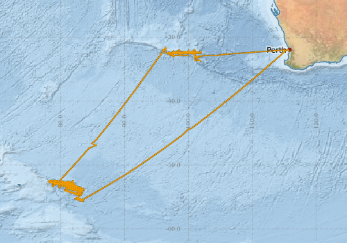
Voyage extents: 55° 43.3' S to 31° 36.4' S 78° 03.8' E to 115° 45.9' E Get voyage track shapefile Get CSV
Marlin Metadata:-
Metadata from OBIS Australia datasets:- biological data is published via the OBIS-AU IPT server and delivered to one or more of OBIS, ALA and GBIF
Download from OBIS Australia IPT View at - Ocean Biodiversity Information System (OBIS) Atlas of Living Australia (ALA) GBIF
Cruise Summary Report at SeaDataNet:-
Participants - on ship:-
| Name | Role | Organisation | Project |
|---|---|---|---|
| George Bernardel | Co-Chief Scientist | Geoscience Australia | Development of William’s Ridge, Kerguelen Plateau: tectonics, hotspot magmatism, microcontinents, and Australia’s Extended Continental Shelf |
| Mike Coffin | Chief Scientist | University of Tasmania - Institute of Marine and Antarctic Studies | Development of William’s Ridge, Kerguelen Plateau: tectonics, hotspot magmatism, microcontinents, and Australia’s Extended Continental Shelf |
Participants - shore based:-
| Name | Role | Organisation | Project |
|---|---|---|---|
| Anthony Koppers | Principal Investigator | Oregon State University (USA) | Development of William’s Ridge, Kerguelen Plateau: tectonics, hotspot magmatism, microcontinents, and Australia’s Extended Continental Shelf |
| Gabriele Uenzelmann-Neben | Principal Investigator | Alfred Wegener Institute (DE) | Development of William’s Ridge, Kerguelen Plateau: tectonics, hotspot magmatism, microcontinents, and Australia’s Extended Continental Shelf |
| Jacqueline Halpin | Principal Investigator | University of Tasmania - Institute of Marine and Antarctic Studies | Development of William’s Ridge, Kerguelen Plateau: tectonics, hotspot magmatism, microcontinents, and Australia’s Extended Continental Shelf |
| Jan Strugnell | Principal Investigator | James Cook University | Using samples from the Kerguelen Plateau to date past West Antarctic ice sheet collapse |
| Joanne Whittaker | Principal Investigator | University of Tasmania - Institute of Marine and Antarctic Studies | Development of William’s Ridge, Kerguelen Plateau: tectonics, hotspot magmatism, microcontinents, and Australia’s Extended Continental Shelf |
| Kaj Hoernle | Principal Investigator | GEOMAR Helmholtz Centre for Ocean Research Kiel, Germany | Development of William’s Ridge, Kerguelen Plateau: tectonics, hotspot magmatism, microcontinents, and Australia’s Extended Continental Shelf |
| Kim Picard | Principal Investigator | Geoscience Australia | Development of William’s Ridge, Kerguelen Plateau: tectonics, hotspot magmatism, microcontinents, and Australia’s Extended Continental Shelf |
| Lynne Talley | Principal Investigator | Scripps Institution of Oceanography (USA) | Development of William’s Ridge, Kerguelen Plateau: tectonics, hotspot magmatism, microcontinents, and Australia’s Extended Continental Shelf |
| Michael Storey | Principal Investigator | Natural History Museum of Denmark (DK) | Development of William’s Ridge, Kerguelen Plateau: tectonics, hotspot magmatism, microcontinents, and Australia’s Extended Continental Shelf |
| Nathan Daczko | Principal Investigator | Macquarie University | Development of William’s Ridge, Kerguelen Plateau: tectonics, hotspot magmatism, microcontinents, and Australia’s Extended Continental Shelf |
| Rebecca Cowley | Principal Investigator | CSIRO Oceans & Atmosphere - Hobart | Argo Float deployment |
| Sally Gibson | Principal Investigator | Cambridge University (UK) | Development of William’s Ridge, Kerguelen Plateau: tectonics, hotspot magmatism, microcontinents, and Australia’s Extended Continental Shelf |
| Sascha Brune | Principal Investigator | GeoForschungsZentrum (GFZ, DE) | Development of William’s Ridge, Kerguelen Plateau: tectonics, hotspot magmatism, microcontinents, and Australia’s Extended Continental Shelf |
This list includes those that may have only been on part of the voyage. See voyage reports on 'Reports and Maps' tab for details.
Marine National Facility Reports - plans, summaries and data processing
-
IN2020_V01 Voyage Plan
- includes objectives, investigator details, proposed data collection, voyage track and equipment to be used.
-
IN2020_V01 ADCP Data Processing Report
- details of data processing steps, calibration information, instruments used and any issues with the data.
-
IN2020_V01 Underway data Processing Report
- details of data processing steps, calibration information, instruments used and any issues with the data.
- View Survey map
Publications, reports and datasets from this voyage.
Conference abstract
- Coffin, Millard; Whittaker, Joanne ; Daczko, Nathan ; Halpin, Jacqueline ; Bernardel, George ; Picard, Kim ; Gardner, Robyn ; Gurer, Derya ; Brune, Sascha, Dr. ; Gibson, Sally ; Hoernle, Kaj ; Koppers, Anthony ; Storey, Michael ; Uenzelmann-Neben, Gabriele ; Magri, Luca ; Neuharth, Derek ; Christiansen, Sascha ; Easton, Laura (2021) Development of Williams Ridge (Kerguelen Plateau) and Broken Ridge: Tectonics, Hotspot Magmatism, Microcontinents, and Australias Extended Continental Shelf External link to reference
Dataset
- Beaman, R.J. (2023) Williams Ridge 100 m Bathymetry grid compilation (20220005C). Geoscience Australia, Canberra. https://dx.10.26186/147484
- Beaman, R.J. (2023). Kerguelen Plateau 100 m Bathymetry grid compilation (20220004C). Geoscience Australia, Canberra. 10.26186/147703
- Coffin, M., Magri, L. and Whittaker, J. (2023) IN2020_V01 - Multichannel Seismic Reflection (MCS) dataset, Ver. 1, Australian Antarctic Data Centre 10.26179/qe01-db93
- Coffin, Mike; Edwards, Stuart; Kuna, Nelson; Navidad, Cisco (2020): IN2020_V01 Broken Ridge Bathymetry 200m resolution Floating Point Geotiff. v1. CSIRO. Data Collection. 10.25919/5f7e3b93126ea
- Coffin, Mike; Edwards, Stuart; Kuna, Nelson; Navidad, Cisco (2020): IN2020_V01 Williams Ridge Bathymetry 100m resolution Floating Point Geotiff. v1. CSIRO. Data Collection. 10.25919/5f7e3bcfe68e8
- Downie, Ryan; Scoulding, Ben; & Nau, Amy (2025): Heard and MacDonald Islands (HIMI) multibeam and single beam bathymetry compilation. v2. CSIRO. Data Collection. 10.25919/7qjy-qw45
- Magri, L. (2025) Numerical models dataset: rifting in Large Igneous Province settings - The William's Ridge (Kerguelen Plateau)-Broken Ridge study case, Ver. 1, Australian Antarctic Data Centre - doi:10.26179/gc1d-2q90 10.26179/gc1d-2q90
- Tilbrook, Bronte; Neill, Craig; Akl, John (2022). Integrated Marine Observing System (IMOS) sea surface and atmospheric fCO2 measurements in the Southern Ocean, South Pacific, Indian Ocean onboard R/V Investigator in 2020 (NCEI Accession 0253534). [indicate subset used]. NOAA National Centers for Environmental Information. Dataset. 10.25921/ctqh-rn91
IPT Resource
- RV Investigator Voyage IN2020_V01 Seabird Observations, Broken Ridge region, Indian Ocean (2020) (Darwin Core Archive) External link to reference
Journal Article
- Asimus, Jeremy L.,Halpin, Jacqueline A.,Daczko, Nathan R.,Whittaker, Joanne M.,Coffin, Millard F.,Belousov, Ivan,Mulder, Jacob A.,Glorie, Stijn (2025) Discovery of the William's Ridge and Rig Seismic Seamount Microcontinents, Kerguelen Plateau: Signatures of a Fragmented Rifted Margin. Tectonics 44 pp-. 10.1029/2025TC008958
- Haris, K.,Kloser, Rudy J.,Ryan, Tim E.,Downie, Ryan A.,Keith, Gordon,Nau, Amy W. (2021) Sounding out life in the deep using acoustic data from ships of opportunity. Scientific Data 8 pp-. 10.1038/s41597-020-00785-8
- Lucieer, Vanessa,Flukes, Emma,Monk, Jacquomo,Walsh, Peter (2024) Geomorphometric maps of Australia’s Marine Park estate and their role in improving the integrated monitoring and management of marine ecosystems. Frontiers in Marine Science 10 pp-. 10.3389/fmars.2023.1302108
- Magri, L.,Neuharth, D.,Williams, S.,Brune, S.,Whittaker, J. M.,Sandiford, D.,Coffin, M. F.,Hochmuth, K.,Glerum, A. (2025) Thermo‐Mechanical Rift Evolution of Large Igneous Province Crust. Tectonics 44 pp-. 10.1029/2025TC008878
- Magri, L.,Whittaker, J. M.,Coffin, M. F.,Hochmuth, K.,Gürer, D.,Williams, S.,Bernardel, G.,Uenzelmann‐Neben, G. (2024) Tectono‐Stratigraphic Evolution of the Kerguelen Large Igneous Province: The Conjugate William’s Ridge‐Broken Ridge Rifted Margins. Journal of Geophysical Research: Solid Earth 129, e2023JB027493. 10.1029/2023jb027493
- Zhang, Haifeng,Beggs, Helen,Griffin, Christopher,Govekar, Pallavi Devidas (2023) Validation of Himawari-8 Sea Surface Temperature Retrievals Using Infrared SST Autonomous Radiometer Measurements. Remote Sensing 15 pp2841-. 10.3390/rs15112841
Report
- Halpin, J., Whittaker, J. and Coffin, M. (2023) RV Investigator Voyage IN2020_V01 Dredge Report 10.26179/7cdy-ca16
Search for publications, reports and datasets from this and other voyages
Data publishing
This is a list of online datasets hosted by CSIRO. Other processed datasets hosted by collaborating organisations may be found on the 'Metadata' or "Reports, Publications and Maps' tab.
Use the Get data link on the right to extract data using the NCMI Data Trawler.
| Data Stream | Data Summary | Get data | ||||||||||||
|---|---|---|---|---|---|---|---|---|---|---|---|---|---|---|
| ADCP Data |
|
Get Data from Trawler Download the ADCP OS150nb Data (NetCDF) Download the ADCP OS150nb Plots Download the ADCP OS75nb Data (NetCDF) Download the ADCP OS75nb Plots |
||||||||||||
| Marine biodiversity observations and/or samples |
|
Get Data from Trawler |
||||||||||||
| Gravity Measurements |
|
Get Data from Trawler Geophysical Survey and Mapping acquisition report |
||||||||||||
| Multibeam echosounder |
|
Get Data from Trawler |
||||||||||||
| pCO2 |
|
External link - download datafile at IMOS Data fields and units document (.pdf) |
||||||||||||
| Radon measurements |
|
Get Data from Trawler Download RV Investigator Radon dataset (XLSX) |
||||||||||||
| Sub-bottom profiler |
|
Get Data from Trawler |
||||||||||||
| Singlebeam echosounder |
|
Get Data from Trawler |
||||||||||||
| SOOP Bio-acoustics |
|
External link - datafile at IMOS NetCDF Data Format: Manual Download |
||||||||||||
| Underway |
|
Get Data from Trawler Download the 10-second Underway data (CSV): in2020_v01uwy10sec_csv.zip Download the 5 second Underway data (CSV): in2020_v01uwy5sec_csv.zip Download the 5 minute Underway data (CSV): in2020_v01uwy5min_csv.zip Download the 1 minute Underway data (CSV): in2020_v01uwy1min_csv.zip Download the 5 second Underway data (NetCDF): in2020_v01uwy_nc.zip |
||||||||||||
| Wildlife Observations |
|
Get Data from Trawler |
||||||||||||
| XBT Profile |
|
Get Data from Trawler Geophysical Survey and Mapping data acquisition and processing report |
| ID | When (UTC) | Lat | Long | Instrument | Identifier | Action | Log | Subject / Comment |
|---|
Deployments by start time:- Click on column header to sort. Use link on 'Deployment' to see full details. Use the CSV button at the bottom to export data (tab delimited).
Search for deployments from this voyage and others
| Deployment | Operation | Station | Cast | Gear | Project | Start and end times | Start Location | End Location | Depth range | Max Depth | Description | |||
|---|---|---|---|---|---|---|---|---|---|---|---|---|---|---|
| Underway System [details] | Air Sampling Inlet Mode,Air Temperature Sensor - ROTRONIC T&RH HC2A-S3,Air Temperature Sensor - ROTRONIC T&RH HC2A-S3,Air Temperature Sensor - ROTRONIC T&RH HC2A-S3,Air Temperature Sensor - ROTRONIC T&RH HC2A-S3,Air Temperature Sensor - ROTRONIC T&RH HC2A-S3,Air Temperature Sensor - ROTRONIC T&RH HC2A-S3,Burket Flow meter,Burket Flow meter,CSIRO Hobart pCO2,CSIRO Hobart pCO2,CSIRO Hobart pCO2,CSIRO Hobart pCO2,CSIRO Hobart pCO2,CSIRO Hobart pCO2,CSIRO Hobart pCO2,CSIRO Hobart pCO2,CSIRO Hobart pCO2,CSIRO Hobart pCO2,CSIRO air sampling inlet,CSIRO air sampling inlet,Depth: TECHSAS-DERIVED. For more information contact the Data Acquisition and Processing group.,Fluorometer Concentration,Fluorometer WSCHL-1441,Gyrocompass,IMOS Port Pyranometer-SN 35122F3,IMOS Port Radiometer-SN 35093F3,IMOS Stbd Pyranometer-SN 29125F3,IMOS Stbd Radiometer-SN 29140F3,IMOS wind monitor,IMOS wind monitor,IMOS wind monitor,IMOS wind monitor,ISAR SST,Kobold MIK-C Flow meter,Kobold MIK-C Fluorometer Flow Meter,Kongsberg Maritime Skipper DL850 doppler log,Kongsberg Maritime Skipper DL850 doppler log,Kongsberg Maritime Skipper DL850 doppler log,Kongsberg Maritime Skipper DL850 doppler log,Kongsberg Maritime Skipper DL850 doppler log,Kongsberg Maritime Skipper DL850 doppler log,LI-COR LI-190R Quantum Sensor,LI-COR LI-190R Quantum Sensor,MAAP Status,Multiangle Absorption Photometer (MAAP),Multiangle Absorption Photometer (MAAP),Optode Dissolved Oxygen Concentration,Optode Dissolved Oxygen Saturation,Optode Water Temperature,Ozone Monitor RVT1,Ozone Monitor RVT1,Ozone Monitor RVT2,Ozone Monitor RVT2,Picarro Greenhouse Gas Spectrometer CO2,CH4,H2o,Picarro Greenhouse Gas Spectrometer CO2,CH4,H2o,Picarro Greenhouse Gas Spectrometer CO2,CH4,H2o,Port Rain Gauge,Port drop keel sensor,RM Young 05106 wind monitor-75621,RM Young 05106 wind monitor-75621,RM Young 05106 wind monitor-75621,RM Young 05106 wind monitor-75621,RM Young 05106 wind monitor-75621,RM Young Wind Sensor Type 05106,RM Young Wind Sensor Type 05106,RM Young Wind Sensor Type 05106,RM Young Wind Sensor Type 05106,Remote Temperature (T) - SN 672,Seapath 330+,Seapath 330+,Seapath 330+,Seapath 330+,Starboard Rain Gauge,Starboard drop keel sensor,ThermoSalinoGraph (TSG)-SN 2567,ThermoSalinoGraph (TSG)-SN 3439,Vaisala Ship's Barometer PTB330 | 2472 | 2020-01-10 00:33 | 2020-03-06 00:09 | -32.1537 | 115.7651 | -32.0507 | 115.7441 | ||||||
| ADCP Data [details] | Teledyne RDI ADCP 75 kHz | 2472 | 2020-01-10 03:13 | 2020-03-05 22:00 | -31.9608 | 115.4887 | -31.9415 | 115.5375 | 814 | |||||
| XBT Cast [details] | Sippican Deep Blue | 2548 | 2020-01-11 20:54 | 1100.3 | ||||||||||
| XBT Cast [details] | Sippican Deep Blue | 2548 | 2020-01-12 16:36 | 1100.3 | ||||||||||
| XBT Cast [details] | Sippican Deep Blue | 2548 | 2020-01-14 12:07 | 1100.3 | ||||||||||
| XBT Cast [details] | Sippican Deep Blue | 2548 | 2020-01-17 17:57 | 444.6 | ||||||||||
| XBT Cast [details] | Sippican Deep Blue | 2548 | 2020-01-17 18:05 | 1100.3 | ||||||||||
| XBT Cast [details] | Sippican Deep Blue | 2548 | 2020-01-18 16:39 | 1100.3 | ||||||||||
| XBT Cast [details] | Sippican Deep Blue | 2548 | 2020-01-18 16:45 | 1100.3 | ||||||||||
| XBT Cast [details] | Sippican Deep Blue | 2548 | 2020-01-18 16:58 | 1100.3 | ||||||||||
| XBT Cast [details] | Sippican Deep Blue | 2548 | 2020-01-21 13:05 | 1100.3 | ||||||||||
| XBT Cast [details] | Sippican Deep Blue | 2548 | 2020-01-21 13:10 | 1100.3 | ||||||||||
| XBT Cast [details] | Sippican Deep Blue | 2548 | 2020-01-24 12:21 | 1100.3 | ||||||||||
| XBT Cast [details] | Sippican Deep Blue | 2548 | 2020-01-24 12:27 | 1100.3 | ||||||||||
| XBT Cast [details] | Sippican Deep Blue | 2548 | 2020-01-26 15:27 | 966.3 | ||||||||||
| XBT Cast [details] | Sippican Deep Blue | 2548 | 2020-01-27 18:47 | 670.9 | ||||||||||
| XBT Cast [details] | Sippican Deep Blue | 2548 | 2020-01-28 09:25 | 1100.3 | ||||||||||
| XBT Cast [details] | Sippican Deep Blue | 2548 | 2020-01-29 12:13 | 1100.3 | ||||||||||
| XBT Cast [details] | Sippican Deep Blue | 2548 | 2020-01-30 11:43 | 1100.3 | ||||||||||
| XBT Cast [details] | Sippican Deep Blue | 2548 | 2020-01-31 00:20 | 1100.3 | ||||||||||
| XBT Cast [details] | Sippican Deep Blue | 2548 | 2020-01-31 10:19 | 1100.3 | ||||||||||
| XBT Cast [details] | Sippican Deep Blue | 2548 | 2020-02-02 09:25 | 1100.3 | ||||||||||
| XBT Cast [details] | Sippican Deep Blue | 2548 | 2020-02-05 18:47 | 784 | ||||||||||
| XBT Cast [details] | Sippican Deep Blue | 2548 | 2020-02-10 09:43 | 1100.3 | ||||||||||
| XBT Cast [details] | Sippican Deep Blue | 2548 | 2020-02-10 09:48 | 1100.3 | ||||||||||
| XBT Cast [details] | Sippican Deep Blue | 2548 | 2020-02-10 09:53 | 1100.3 | ||||||||||
| XBT Cast [details] | Sippican Deep Blue | 2548 | 2020-02-11 09:17 | 1100.3 | ||||||||||
| XBT Cast [details] | Sippican Deep Blue | 2548 | 2020-02-13 12:23 | 1100.3 | ||||||||||
| XBT Cast [details] | Sippican Deep Blue | 2548 | 2020-02-16 18:07 | 969.8 | ||||||||||
| XBT Cast [details] | Sippican Deep Blue | 2548 | 2020-02-18 13:04 | 1100.3 | ||||||||||
| XBT Cast [details] | Sippican Deep Blue | 2548 | 2020-02-19 09:24 | 1100.3 | ||||||||||
| XBT Cast [details] | Sippican Deep Blue | 2548 | 2020-02-20 20:23 | 1100.3 | ||||||||||
| XBT Cast [details] | Sippican Deep Blue | 2548 | 2020-02-26 09:20 | 1100.3 | ||||||||||
| XBT Cast [details] | Sippican Deep Blue | 2548 | 2020-02-26 09:24 | 1100.3 | ||||||||||
| XBT Cast [details] | Sippican Deep Blue | 2548 | 2020-02-27 00:09 | 1100.3 | ||||||||||
| XBT Cast [details] | Sippican Deep Blue | 2548 | 2020-02-27 09:20 | 1100.3 | ||||||||||
| XBT Cast [details] | Sippican Deep Blue | 2548 | 2020-02-27 23:15 | 1100.3 | ||||||||||
| XBT Cast [details] | Sippican Deep Blue | 2548 | 2020-02-28 09:23 | 1100.3 | ||||||||||
| XBT Cast [details] | Sippican Deep Blue | 2548 | 2020-02-29 00:02 | 1065.3 | ||||||||||
| XBT Cast [details] | Sippican Deep Blue | 2548 | 2020-02-29 00:06 | 1100.3 | ||||||||||
| XBT Cast [details] | Sippican Deep Blue | 2548 | 2020-02-29 09:15 | 1100.3 | ||||||||||
| XBT Cast [details] | Sippican Deep Blue | 2548 | 2020-03-01 22:41 | 1100.3 | ||||||||||
| XBT Cast [details] | Sippican Deep Blue | 2548 | 2020-03-03 12:46 | 1100.3 | ||||||||||
| XBT Cast [details] | Sippican Deep Blue | 2548 | 2020-03-03 12:50 | 1100.3 | ||||||||||
| XBT Cast [details] | Sippican Deep Blue | 2548 | 2020-03-04 13:00 | 1100.3 | ||||||||||