Voyage details and related metadata, reports, events and data.
IN2018_V08
- is a Marine National Facility ![]() voyage
voyage
Title: The Balleny mantle plume: key role in Tasmania-Antarctic breakup?
Voyage details on MNF site: https://mnf.csiro.au/en/Voyages/IN2018_V08
Period: 2018-12-26 23:00 to 2019-01-09 23:00 UTC
Duration: 14.00 days
From: Hobart To: Hobart
Region: Southern Ocean; Tasman Sea
Ship: Investigator (RV) [details]
Description: RV Investigator research voyage in2018_v08, titled "The Balleny mantle plume: key role in Tasmania-Antarctic breakup?" Objective 1. Collect seafloor and subseafloor geophysical data. This data will be used: a. To identify seafloor fabric, which will help refine plate reconstructions of the Tasman Seas in areas difficult to constrain from magnetic anomaly lineations alone; b. To obtain comprehensive multibeam and backscatter coverage of the seamounts and their morphology to understand tectonic setting, eruptive style, palaeo-water-depth and sedimentation patterns; c. To assist in dredge site targeting by identifying sediment-free scarps and slopes; d. Sub-bottom profile data will be collected to provide additional context for the nature of the near-surface sediment and geological structure. Objective 2. Dredge volcanic samples from seamounts along the proposed Balleny Seamount chain. Ashore, samples will be: a. Ar/Ar Dated to determine the age and duration of seamount formation; b. Volcanic coherent rocks will be described macroscopically, petrographically and mineralogically to classify and characterise the type volcanism on the seamounts. Comparing the nature and origin of volcanism at different sites may reveal multiple episodes of volcanism or variations in volcanic activity in time and space. c. Volcaniclastic rocks will be described macroscopically, petrographically, mineralogically and include ash morphology descriptions. This work will constrain submarine/subaerial eruption/emplacement and style of transport d. Sedimentary rocks will be described macroscopically, microscopically and petrographically. Additional U-Pb geochronology will be undertaken as will micro- and macro-fossil palaeontology. These analyses can constrain depth, environment, and time of deposition, important for constraining the timing and rate of subsidence.
Leader: Joanne Whittaker (UTAS)
Project: The Balleny mantle plume: key role in Tasmania-Antarctic breakup? [details] Primary
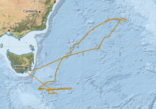
Voyage extents: 46° 23.9' S to 36° 07.2' S 147° 20.3' E to 160° 46.4' E
Marlin Metadata:-
Cruise Summary Report at SeaDataNet:-
Participants - on ship:-
| Name | Role | Organisation | Project |
|---|---|---|---|
| Joanne Whittaker | Chief Scientist | University of Tasmania | The Balleny mantle plume: key role in Tasmania-Antarctic breakup? |
| Matt Kimber | Voyage Manager | Marine National Facility | Voyage Management on RV Investigator |
| Rebecca Carey | Alt. Chief Scientist | University of Tasmania | The Balleny mantle plume: key role in Tasmania-Antarctic breakup? |
This list includes those that may have only been on part of the voyage. See voyage reports on 'Reports and Maps' tab for details.
Marine National Facility Reports - plans, summaries and data processing
-
IN2018_V08 Voyage Scientific Highlights and Summary.pdf
- includes preliminary results, voyage narrative, types of data collected with C77/ROSCOP codes.
-
IN2018_V08 ADCP Data Processing Report
- details of data processing steps, calibration information, instruments used and any issues with the data.
-
IN2018_V08 Underway Data Processing Report
- details of data processing steps, calibration information, instruments used and any issues with the data.
-
IN2018_V08 Voyage Plan
- includes objectives, investigator details, proposed data collection, voyage track and equipment to be used.
- View Survey map
Publications, reports and datasets from this voyage.
Dataset
- Carey, R.J. and Whittaker, J. (2026) Whole rock geochemistry - radiogenic isotopes - from selected basalts dredged from seamounts in the south Tasman Sea during RV Investigator voyage IN2018_V08, Ver. 1, Australian Antarctic Data Centre - doi:10.26179/dsjr-m419, (Unreleased data) 10.26179/dsjr-m419
- Carey, R.J. and Whittaker, J. (2026) Whole rock geochemistry – major elements - from selected basalts dredged from seamounts in the south Tasman Sea during RV Investigator voyage IN2018_V08, Ver. 1, Australian Antarctic Data Centre - doi:10.26179/1k6b-vh26, (Unreleased data) 10.26179/1k6b-vh26
- Carey, R.J. and Whittaker, J. (2026) Whole rock geochemistry – trace elements - from selected basalts dredged from seamounts in the south Tasman Sea during RV Investigator voyage IN2018_V08, Ver. 1, Australian Antarctic Data Centre - doi:10.26179/ar4z-bc36, (Unreleased data) 10.26179/ar4z-bc36
- Tilbrook, Bronte; Neill, Craig; Akl, John (2020). Integrated Marine Observing System (IMOS) sea surface and atmospheric fCO2 measurements in the Southern Ocean onboard R/V Investigator in 2018 (NCEI Accession 0209040). [indicate subset used]. NOAA National Centers for Environmental Information. Dataset. 10.25921/wry5-9f26
- Whittaker, J., Carey, R.J. (2026) Rock sample descriptions for samples dredged during voyage IN2018_V08, Ver. 1, Australian Antarctic Data Centre -, (Unreleased data) 10.26179/qj09-re85
- Whittaker, Joanne. and Carey, Rebecca (2018) Dredge Samples from IN2018_V08. IMAS Metadata External link to reference
- Whittaker, Joanne; Vandenbossche, Phil; Jill, Brouwer; Navidad, Cisco; Boyd, Matt; Fox, Ruby (2024): IN2018_V08 Tasman Sea Bathymetry 10m - 210m Multi-resolution AusSeabed products. v1. CSIRO. Data Collection. 10.25919/wfqv-5t89
Journal Article
- Kanaya, Yugo,Sommariva, Roberto,Saiz-Lopez, Alfonso,Mazzeo, Andrea,Koenig, Theodore K.,Kawana, Kaori,Johnson, James E.,Colomb, Aurélie,Tulet, Pierre,Molloy, Suzie,Galbally, Ian E.,Volkamer, Rainer,Mahajan, Anoop,Halfacre, John W.,Shepson, Paul B.,Schmale, Julia,Angot, Hélène,Blomquist, Byron,Shupe, Matthew D.,Helmig, Detlev (2025) Observational ozone datasets over the global oceans and polar regions (version 2024). Earth System Science Data 17 pp4901-4932. 10.5194/essd-17-4901-2025
- Lucieer, Vanessa,Flukes, Emma,Monk, Jacquomo,Walsh, Peter (2024) Geomorphometric maps of Australia’s Marine Park estate and their role in improving the integrated monitoring and management of marine ecosystems. Frontiers in Marine Science 10 pp-. 10.3389/fmars.2023.1302108
Project
- Carey, Rebecca. Opening of the Tasman sea and the separation of Australia and Antarctica: temporal and isotopic constraints to further test the deep-seated Balleny plume vs. tectonic reorganization models. AAD project 4598. External link to reference
Search for publications, reports and datasets from this and other voyages
Data publishing
This is a list of online datasets hosted by CSIRO. Other processed datasets hosted by collaborating organisations may be found on the 'Metadata' or "Reports, Publications and Maps' tab.
Use the Get data link on the right to extract data using the NCMI Data Trawler.
| Data Stream | Data Summary | Get data | ||||||||||||||
|---|---|---|---|---|---|---|---|---|---|---|---|---|---|---|---|---|
| ADCP Data |
|
Get Data from Trawler Download overview plots of collected data Download overview plots of collected data Download ADCP Data (NetCDF, 5 minute) |
||||||||||||||
| Gravity Measurements |
|
Get Data from Trawler Geophysical Survey and Mapping acquisition report |
||||||||||||||
| Multibeam echosounder |
|
Get Data from Trawler |
||||||||||||||
| pCO2 |
|
External link - download datafile at IMOS Data fields and units document (.pdf) |
||||||||||||||
| Radon measurements |
|
Get Data from Trawler Download RV Investigator Radon dataset (XLSX) |
||||||||||||||
| Sub-bottom profiler |
|
Get Data from Trawler Geophysical Survey and Mapping data acquisition and processing report |
||||||||||||||
| Singlebeam echosounder |
|
Get Data from Trawler Geophysical Survey and Mapping acquisition report |
||||||||||||||
| SOOP Bio-acoustics |
|
External link
Transect 2 - datafile at IMOS NetCDF Data Format: Manual Download |
||||||||||||||
| Underway |
|
Get Data from Trawler Download the 10-second Underway data (CSV format) (when available) Download the 5 minute Underway data (CSV format) (when available) Download the 5 second Underway data (NetCDF format) (when available) |
||||||||||||||
| XBT Profile |
|
Get Data from Trawler |
| ID | When (UTC) | Lat | Long | Instrument | Identifier | Action | Log | Subject / Comment |
|---|
Deployments by start time:- Click on column header to sort. Use link on 'Deployment' to see full details. Use the CSV button at the bottom to export data (tab delimited).
Search for deployments from this voyage and others
| Deployment | Operation | Station | Cast | Gear | Project | Start and end times | Start Location | End Location | Depth range | Max Depth | Description | |||
|---|---|---|---|---|---|---|---|---|---|---|---|---|---|---|
| Underway System [details] | Altimeter-163,Burket Flow meter,Burket Flow meter,CSIRO Hobart pCO2,CSIRO Hobart pCO2,CSIRO Hobart pCO2,CSIRO Hobart pCO2,CSIRO Hobart pCO2,CSIRO Hobart pCO2,CSIRO Hobart pCO2,CSIRO Hobart pCO2,CSIRO Hobart pCO2,CSIRO Hobart pCO2,CSIRO air sampling inlet,CSIRO air sampling inlet,Chelsea Tech Fluorometer,Gyrocompass,Humidity Sensor-HMT333,Humidity Sensor-HMT333,Humidity Sensor-HMT333,Humidity Sensor-HMT333,IMOS Port Pyranometer-SN 29125F3,IMOS Port Radiometer-SN 29140F3,IMOS Stbd Pyranometer-SN 29125F3,IMOS Stbd Radiometer-SN 29140F3,IMOS wind monitor,IMOS wind monitor,IMOS wind monitor,IMOS wind monitor,ISAR SST,Kobold MIK-C Flow meter,Kongsberg Maritime Skipper DL850 doppler log,Kongsberg Maritime Skipper DL850 doppler log,Kongsberg Maritime Skipper DL850 doppler log,Kongsberg Maritime Skipper DL850 doppler log,Kongsberg Maritime Skipper DL850 doppler log,Kongsberg Maritime Skipper DL850 doppler log,LI-COR LI-190 Quantum Sensor,LI-COR LI-190 Quantum Sensor,Multiangle Absorption Photometer (MAAP),Multiangle Absorption Photometer (MAAP),Ozone Monitor RVT1,Ozone Monitor RVT1,Ozone Monitor RVT2,Ozone Monitor RVT2,Picarro Greenhouse Gas Spectrometer CO2,CH4,H2o,Picarro Greenhouse Gas Spectrometer CO2,CH4,H2o,Picarro Greenhouse Gas Spectrometer CO2,CH4,H2o,Port drop keel sensor,RM Young 05106 wind monitor-SN 82705,RM Young Wind Sensor Type 05107,RM Young Wind Sensor Type 05107,RM Young Wind Sensor Type 05107,RM Young Wind Sensor Type 05107,RM Young Wind Sensor Type 05108,RM Young Wind Sensor Type 05108,RM Young Wind Sensor Type 05108,RM Young Wind Sensor Type 05108,Remote Temperature (T) - SN 671,Seapath 330+,Seapath 330+,Seapath 330+,Simrad EK60 multi-frequency split-beam echosounder,Starboard drop keel sensor,ThermoSalinoGraph (TSG)-SN 3439,ThermoSalinoGraph (TSG)-SS-SN 1777,Vaisala Ship's Barometer PTB330 | 2469 | 2018-12-26 22:06 | 2019-01-09 22:22 | -42.8864 | 147.3388 | ||||||||
| ADCP Data [details] | Teledyne RDI ADCP 75 kHz | 2469 | 2018-12-27 12:50 | 2019-01-10 08:01 | -43.2643 | 147.7974 | -43.0391 | 147.3853 | 814 | |||||
| XBT Cast [details] | Sippican Deep Blue | 2548 | 2018-12-28 18:53 | 216 | ||||||||||
| XBT Cast [details] | Sippican Deep Blue | 2548 | 2018-12-28 18:56 | 1100.3 | ||||||||||
| XBT Cast [details] | Sippican Deep Blue | 2548 | 2018-12-29 08:43 | 948.2 | ||||||||||
| XBT Cast [details] | Sippican Deep Blue | 2548 | 2018-12-30 02:13 | 358.6 | ||||||||||
| XBT Cast [details] | Sippican Deep Blue | 2548 | 2018-12-30 02:19 | 1501.1 | ||||||||||
| XBT Cast [details] | Sippican Deep Blue | 2548 | 2018-12-30 19:47 | 1100.3 | ||||||||||
| XBT Cast [details] | Sippican Deep Blue | 2548 | 2019-01-01 02:05 | 1076 | ||||||||||
| XBT Cast [details] | Sippican Deep Blue | 2548 | 2019-01-02 08:24 | 958.4 | ||||||||||
| XBT Cast [details] | Sippican Deep Blue | 2548 | 2019-01-03 02:07 | 1008.8 | ||||||||||
| XBT Cast [details] | Sippican Deep Blue | 2548 | 2019-01-03 23:19 | 1100.3 | ||||||||||
| XBT Cast [details] | Sippican Deep Blue | 2548 | 2019-01-04 08:21 | 1100.3 | ||||||||||
| XBT Cast [details] | Sippican Deep Blue | 2548 | 2019-01-05 19:59 | 1100.3 | ||||||||||
| XBT Cast [details] | Sippican Deep Blue | 2548 | 2019-01-07 08:32 | 1100.3 | ||||||||||
| XBT Cast [details] | Sippican Deep Blue | 2548 | 2019-01-07 19:32 | 1100.3 | ||||||||||
| XBT Cast [details] | Sippican Deep Blue | 2548 | 2019-01-08 02:04 | 1100.3 | ||||||||||
| XBT Cast [details] | Sippican Deep Blue | 2548 | 2019-01-08 22:35 | 1100.3 | ||||||||||