Survey details and related metadata, reports, events and data.
SS 05/91 (alternative identifier: SS199105)
Period: 1991-11-18 00:00 to 1991-12-05 00:00 UTC
Duration: 17.00 days
From: Gove To: Cairns
Region: Gulf of Carpentaria and Great Barrier Reef
Ship: Southern Surveyor [details]
Description: Southern Surveyor cruise SS 05/91 was undertaken to carry out a demersal fish survey, and benthic sampling in the areas of the northern Gulf of Carpentaria, including the fish management zone and the Great Barrier Reef protection zone. Cruise objectives were to determine the species composition, distribution and abundance of demersal fish; collect samples for estimating fish population parameters; search for juvenile Lutjanus malabaricus in shallow areas on the eastern and western borders of the northern GOC; determine the benthic invertebrate fauna; collect hydrological data; collect sediment samples to determine the structure of the substrate and the composition of the infauna and to retain specimens for genetic studies of various species including Lutjanids, Monacanthids and squid.
Leader: J. Salini (CSIRO)
Project: The fish resources of tropical north-eastern Australian waters (FIRDC project no. 88/77) 1989-1992 [details]
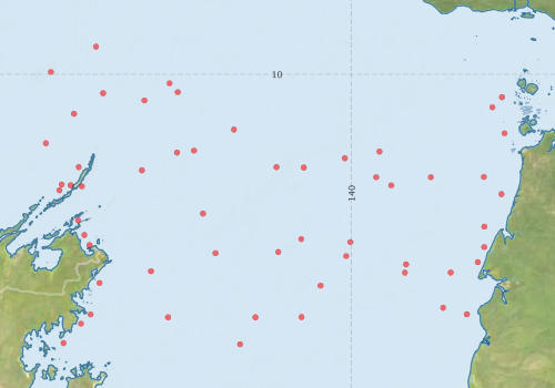
Voyage extents: 17° 00.0' S to 8° 00.0' S 135° 00.0' E to 144° 00.0' E
Marlin Metadata:-
Metadata from OBIS Australia datasets:- biological data is published via the OBIS-AU IPT server and delivered to one or more of OBIS, ALA and GBIF
Download from OBIS Australia IPT View at - Ocean Biodiversity Information System (OBIS) Atlas of Living Australia (ALA) GBIF
Download from OBIS Australia IPT View at - Ocean Biodiversity Information System (OBIS) Atlas of Living Australia (ALA) GBIF
Download from OBIS Australia IPT View at - Ocean Biodiversity Information System (OBIS) Atlas of Living Australia (ALA) GBIF
Participants - on ship:-
| Name | Role | Organisation |
|---|---|---|
| B Long | CSIRO Division of Fisheries | |
| C Liron | CSIRO Division of Fisheries | |
| D Brewer | CSIRO Division of Fisheries | |
| D Milton | CSIRO Division of Fisheries | |
| J Johnson | Queensland Museum | |
| Jeff Cordell | CSIRO Division of Fisheries | |
| John Salini | CSIRO Division of Fisheries | |
| R Williams | Northern Territory Museum | |
| S Bruce | Northern Territory Museum | |
| S Cook | Queensland Museum | |
| S McKinnon | Qld DPI Fisheries | |
| Ted Wassenberg | CSIRO Division of Fisheries |
This list includes those that may have only been on part of the voyage. See voyage reports on 'Reports and Maps' tab for details.
Marine National Facility Reports - plans, summaries and data processing
-
SS199105 Voyage Summary
- includes preliminary results, voyage narrative, types of data collected with C77/ROSCOP codes.
-
SS199105 Voyage Plan
- includes objectives, investigator details, proposed data collection, voyage track and equipment to be used.
-

Publications, reports and datasets from this voyage.
IPT Resource
- Australian National Fish Collection (ANFC) (Darwin Core Archive) External link to reference
- Distribution of seabirds at sea in the Gulf of Carpentaria, Australia (1990-1991) (Darwin Core Archive) External link to reference
- North Marine Region demersal fish and invertebrate collection records (DEW collation), Australia (1980 - 1997) (Darwin Core Archive) External link to reference
Journal Article
- Dunning, M,McKinnon, S,Lu, CC,Yeatman, J,Cameron, D (1994) Demersal cephalopods of the Gulf of Carpentaria, Australia. Marine and Freshwater Research 45 pp351-. 10.1071/MF9940351
- Martin, TJ,Brewer, DT,Blaber, SJM (1995) Factors affecting distribution and abundance of small demersal fishes in the Gulf of Carpentaria, Australia. Marine and Freshwater Research 46 pp909-. 10.1071/MF9950909
- Staunton-Smith, J.,Blaber, S. J. M.,Greenwood, J. G. (1999) Interspecific differences in the distribution of adult and juvenile ponyfish (Leiognathidae) in the Gulf of Carpentaria, Australia. Marine and Freshwater Research 50 pp643-. 10.1071/MF99007
Search for publications, reports and datasets from this and other voyages
Data publishing
This is a list of online datasets hosted by CSIRO. Other processed datasets hosted by collaborating organisations may be found on the 'Metadata' or "Reports, Publications and Maps' tab.
Use the Get data link on the right to extract data using the NCMI Data Trawler.
| Data Stream | Data Summary | Get data | ||||||||||||
|---|---|---|---|---|---|---|---|---|---|---|---|---|---|---|
| Marine biodiversity observations and/or samples |
|
Get Data from Trawler |
Deployments by start time:- Click on column header to sort. Use link on 'Deployment' to see full details. Use the CSV button at the bottom to export data (tab delimited).
Search for deployments from this voyage and others
| Deployment | Operation | Station | Cast | Gear | Project | Start and end times | Start Location | End Location | Depth range | Max Depth | Description | |||
|---|---|---|---|---|---|---|---|---|---|---|---|---|---|---|
| Sediment Sampling [details] | 1 | 543 | -12.1528 | 136.7017 | ||||||||||
| Sediment Sampling [details] | 9 | 543 | -11.1700 | 136.5667 | ||||||||||
| Sediment Sampling [details] | 11 | 543 | -11.4617 | 136.3233 | ||||||||||
| Sediment Sampling [details] | 12 | 543 | -10.8700 | 136.1532 | ||||||||||
| Sediment Sampling [details] | 13 | 543 | -10.4983 | 136.5067 | ||||||||||
| Sediment Sampling [details] | 14 | 543 | -9.9717 | 136.2167 | ||||||||||
| Sediment Sampling [details] | 15 | 543 | -9.6533 | 136.7833 | ||||||||||
| Sediment Sampling [details] | 16 | 543 | -10.2400 | 136.8733 | ||||||||||
| Sediment Sampling [details] | 17 | 543 | -10.3300 | 137.3933 | ||||||||||
| Sediment Sampling [details] | 18 | 543 | -10.1133 | 137.7083 | ||||||||||
| Sediment Sampling [details] | 19 | 543 | -10.2267 | 137.8117 | ||||||||||
| Sediment Sampling [details] | 20 | 543 | -10.6967 | 138.5183 | ||||||||||
| Sediment Sampling [details] | 21 | 543 | -10.9617 | 138.0167 | ||||||||||
| Sediment Sampling [details] | 22 | 543 | -10.9867 | 137.8033 | ||||||||||
| Sediment Sampling [details] | 23 | 543 | -11.2100 | 137.3617 | ||||||||||
| Sediment Sampling [details] | 24 | 543 | -11.3900 | 136.3517 | ||||||||||
| Sediment Sampling [details] | 26 | 543 | -11.7550 | 138.1300 | ||||||||||
| Sediment Sampling [details] | 27 | 543 | -12.2533 | 138.2867 | ||||||||||
| Sediment Sampling [details] | 28 | 543 | -12.4817 | 137.4750 | ||||||||||
| Sediment Sampling [details] | 29 | 543 | -12.6300 | 136.8283 | ||||||||||
| Sediment Sampling [details] | 3 | 543 | -12.0250 | 136.6367 | ||||||||||
| Sediment Sampling [details] | 30 | 543 | -13.0250 | 136.7167 | ||||||||||
| Sediment Sampling [details] | 31 | 543 | -13.1417 | 136.5950 | ||||||||||
| Sediment Sampling [details] | 32 | 543 | -13.3867 | 136.3750 | ||||||||||
| Sediment Sampling [details] | 33 | 543 | -13.0617 | 137.6900 | ||||||||||
| Sediment Sampling [details] | 34 | 543 | -13.4017 | 138.5967 | ||||||||||
| Sediment Sampling [details] | 35 | 543 | -13.0617 | 138.7900 | ||||||||||
| Sediment Sampling [details] | 36 | 543 | -13.0585 | 139.3683 | ||||||||||
| Sediment Sampling [details] | 37 | 543 | -12.6633 | 139.6083 | ||||||||||
| Sediment Sampling [details] | 38 | 543 | -12.2400 | 139.0767 | ||||||||||
| Sediment Sampling [details] | 39 | 543 | -12.0767 | 139.3650 | ||||||||||
| Sediment Sampling [details] | 4 | 543 | -11.8400 | 136.5583 | ||||||||||
| Sediment Sampling [details] | 40 | 543 | -12.1150 | 139.9833 | ||||||||||
| Sediment Sampling [details] | 41 | 543 | -12.2900 | 139.9317 | ||||||||||
| Sediment Sampling [details] | 42 | 543 | -12.3950 | 140.6850 | ||||||||||
| Sediment Sampling [details] | 43 | 543 | -12.5000 | 140.6700 | ||||||||||
| Sediment Sampling [details] | 44 | 543 | -12.9417 | 141.1517 | ||||||||||
| Sediment Sampling [details] | 45 | 543 | -13.0233 | 141.4500 | ||||||||||
| Sediment Sampling [details] | 46 | 543 | -12.4983 | 141.2450 | ||||||||||
| Sediment Sampling [details] | 47 | 543 | -12.3667 | 141.5867 | ||||||||||
| Sediment Sampling [details] | 48 | 543 | -12.1767 | 141.6683 | ||||||||||
| Sediment Sampling [details] | 49 | 543 | -11.9200 | 141.6700 | ||||||||||
| Sediment Sampling [details] | 50 | 543 | -11.5100 | 141.8850 | ||||||||||
| Sediment Sampling [details] | 51 | 543 | -11.2933 | 141.6633 | ||||||||||
| Sediment Sampling [details] | 52 | 543 | -11.2967 | 140.9967 | ||||||||||
| Sediment Sampling [details] | 53 | 543 | -11.2967 | 140.3083 | ||||||||||
| Sediment Sampling [details] | 54 | 543 | -11.4000 | 140.4983 | ||||||||||
| Sediment Sampling [details] | 55 | 543 | -11.1700 | 139.0533 | ||||||||||
| Sediment Sampling [details] | 56 | 543 | -11.1750 | 139.3967 | ||||||||||
| Sediment Sampling [details] | 57 | 543 | -11.0583 | 139.9133 | ||||||||||
| Sediment Sampling [details] | 58 | 543 | -10.9750 | 140.3500 | ||||||||||
| Sediment Sampling [details] | 6 | 543 | -11.4133 | 136.6067 | ||||||||||
| Sediment Sampling [details] | 62 | 543 | -10.7450 | 141.9233 | ||||||||||
| Sediment Sampling [details] | 63 | 543 | -10.4167 | 141.7700 | ||||||||||
| Sediment Sampling [details] | 65 | 543 | -10.2883 | 141.8917 | ||||||||||
| Sediment Sampling [details] | 10 | 543 | -11.3983 | 136.4650 | ||||||||||