Voyage details and related metadata, reports, events and data.
IN2020_V06
- is a Marine National Facility ![]() voyage
voyage
Title: Probing the Australian-Pacific Plate Boundary: Macquarie Ridge in 3-D
Voyage details on MNF site: https://mnf.csiro.au/en/Voyages/IN2020_V06
Period: 2020-10-08 01:00 to 2020-11-02 21:20 UTC
Duration: 25.85 days
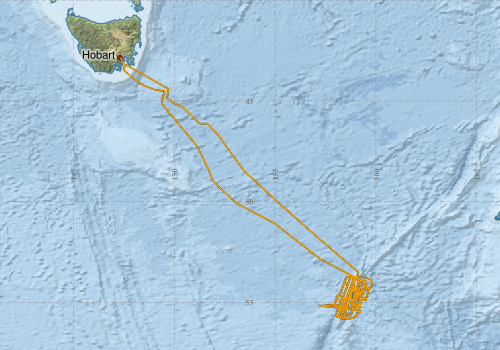
From: Hobart To: Hobart
Ship: Investigator (RV) [details]
Description: The primary objectives of the voyage are to acquire passive seismological data that will enable us to:
- Characterise the 3-D structure of the oceanic crust and sub-crustal lithosphere along the Macquarie Ridge Complex (MRC) with novel lithospheric seismic imaging. This includes teleseismic receiver function analysis, teleseismic and ambient noise tomography, joint inversion of receiver functions and ambient noise dispersion, shear wave splitting analysis, autocorrelation analysis, and enhancing of regional and teleseismic wavefield through array seismology.
- Describe the structural, thermal, and compositional nature of the central MRC by applying a range of seismic imaging techniques to identify velocity anomalies in the crust and mantle. This is possible because 2-D or 3-D images of velocity anomalies in the crust and mantle may be interpreted as structural, thermal, or compositional variations.
- Define sites for OBS deployments in the vicinity of Macquarie Island using multibeam sonar and sub-bottom profiling data. Pending scheduled testing later this year, deployment parameters are tentatively in water depths =1000 m and on gentle seafloor slopes, ideally flat, but not to exceed 30°. Sediment cover is preferred over bare igneous rock for OBS deployment. Existing data around Macquarie Island are not of sufficient quality to define deployment sites.
- Characterise the neotectonics, structure, and stratigraphy of the active Australian-Pacific plate boundary in the vicinity of Macquarie Island using multibeam sonar (both bathymetry and backscatter), sub-bottom profiling, gravity, and magnetics data. These data will also provide critical baseline information for benthic habitat mapping.
Leader: Dr Coffin (UTAS)
Project: Probing the Australian-Pacific plate boundary: Macquarie Ridge in 3-D [details] Primary
Underway data from NRUD - see this voyage
Voyage extents: 55° 49.5' S to 42° 53.1' S 147° 20.3' E to 159° 48.6' E Get voyage track shapefile Get CSV
Marlin Metadata:-
Cruise Summary Report at SeaDataNet:-
Participants - on ship:-
| Name | Role | Organisation | Project |
|---|---|---|---|
| Caroline Eakin | Seismologist | Australian National University - Research School of Earth Sciences | Probing the Australian-Pacific plate boundary: Macquarie Ridge in 3-D |
| Hrvoje Tkalcic | Alternate Chief Scientist | Australian National University - Research School of Earth Sciences | Probing the Australian-Pacific plate boundary: Macquarie Ridge in 3-D |
| Mike Coffin | Chief Scientist | University of Tasmania - Institute of Marine and Antarctic Studies | Probing the Australian-Pacific plate boundary: Macquarie Ridge in 3-D |
Participants - shore based:-
| Name | Role | Organisation | Project |
|---|---|---|---|
| Joann Stock | Principal Investigator | California Institute of Technology | Probing the Australian-Pacific plate boundary: Macquarie Ridge in 3-D |
| Nicholas Rawlinson | Principal Investigator | Cambridge University (UK) | Probing the Australian-Pacific plate boundary: Macquarie Ridge in 3-D |
This list includes those that may have only been on part of the voyage. See voyage reports on 'Reports and Maps' tab for details.
Marine National Facility Reports - plans, summaries and data processing
-
IN2020_V06 Scientific Highlights
- report of the key outputs
-
IN2020_V06 Voyage Summary
- includes preliminary results, voyage narrative, types of data collected with C77/ROSCOP codes.
-
IN2020_V06 ADCP Data Processing Report
- details of data processing steps, calibration information, instruments used and any issues with the data.
-
IN2020_V06 Underway Data Processing Report
- details of data processing steps, calibration information, instruments used and any issues with the data.
-
IN2020_V06 Voyage Plan
- includes objectives, investigator details, proposed data collection, voyage track and equipment to be used.
- View Survey map
Publications, reports and datasets from this voyage.
Conference abstract
- Ma, X., Tkalčić, H., Eakin, C., Rawlinson, N., Pham, T.-S., Winder, T., Pickle, R., Coffin, M., and Stock, J. and the Macquarie Ridge 3D Team: Crustal Structure of the Macquarie Ridge Complex Constrained by the Ambient Noise and Earthquake Autocorrelograms, EGU General Assembly 2023, Vienna, Austria, 24–28 Apr 2023, EGU23-10875,
10.5194/egusphere-egu23-10875
- Pham, T.-S., Tkalcic, H., Ma, X., Pickle, R., Muir, J., Duru, K., Winder, T., Rawlinson, N., Eakin, C., Coffin, M., and Stock, J. and the Macquarie Ridge 3D Team: Probabilistic ambient noise imaging of the Macquarie Ridge Complex using ocean-bottom and land-based seismometers, EGU General Assembly 2023, Vienna, Austria, 24–28 Apr 2023, EGU23-10662,
10.5194/egusphere-egu23-10662
- Rawlinson, N., Winder, T., Tkalcic, H., Stock, J., and Coffin, M.: Microseismicity of the Macquarie Ridge Complex, EGU General Assembly 2023, Vienna, Austria, 24–28 Apr 2023, EGU23-9886,
10.5194/egusphere-egu23-9886
Dataset
- Coffin, Mike; Vandenbossche, Phil; Navidad, Cisco; Boyd, Matt; & Gifford, Davina (2024): IN2020_V06 Macquarie Island Bathymetry 10m - 210m Multi-resolution AusSeabed products. 10.25919/vss6-mz18
- Tilbrook, Bronte; Neill, Craig; Akl, John (2022). Integrated Marine Observing System (IMOS) sea surface and atmospheric fCO2 measurements in the Southern Ocean, South Pacific, Indian Ocean onboard R/V Investigator in 2020 (NCEI Accession 0253534). [indicate subset used]. NOAA National Centers for Environmental Information. Dataset. 10.25921/ctqh-rn91
Journal Article
- Haris, K.,Kloser, Rudy J.,Ryan, Tim E.,Downie, Ryan A.,Keith, Gordon,Nau, Amy W. (2021) Sounding out life in the deep using acoustic data from ships of opportunity. Scientific Data 8 pp-. 10.1038/s41597-020-00785-8
- Lucieer, Vanessa,Flukes, Emma,Monk, Jacquomo,Walsh, Peter (2024) Geomorphometric maps of Australia’s Marine Park estate and their role in improving the integrated monitoring and management of marine ecosystems. Frontiers in Marine Science 10 pp-. 10.3389/fmars.2023.1302108
Magazine Article
- Tkalčić, Hrvoje,Eakin, Caroline,Coffin, Millard,Rawlinson, Nicholas,Stock, Joann (2021) Deploying a Submarine Seismic Observatory in the Furious Fifties. Eos 102 pp-. 10.1029/2021EO159537
Online Publication
- Shaking up earthquake science on Macquarie Island, Australian Antarctic Division News Communique, 6 July 2021. https://www.antarctica.gov.au/news/ External link to reference
Search for publications, reports and datasets from this and other voyages
Data publishing
This is a list of online datasets hosted by CSIRO. Other processed datasets hosted by collaborating organisations may be found on the 'Metadata' or "Reports, Publications and Maps' tab.
Use the Get data link on the right to extract data using the NCMI Data Trawler.
| Data Stream | Data Summary | Get data | ||||||||||||||
|---|---|---|---|---|---|---|---|---|---|---|---|---|---|---|---|---|
| ADCP Data |
|
Get Data from Trawler Download the OS75 NetCDF Data Download the OS150 NetCDF Data |
||||||||||||||
| Gravity Measurements |
|
Get Data from Trawler |
||||||||||||||
| Multibeam echosounder |
|
Get Data from Trawler |
||||||||||||||
| pCO2 |
|
External link - download datafile at IMOS Data fields and units document (.pdf) |
||||||||||||||
| Sub-bottom profiler |
|
Get Data from Trawler Geophysical Survey and Mapping data acquisition and processing report |
||||||||||||||
| Singlebeam echosounder |
|
Get Data from Trawler Geophysical Survey and Mapping acquisition report |
||||||||||||||
| SOOP Bio-acoustics |
|
External link
Transect 2 - datafile at IMOS NetCDF Data Format: Manual Download |
||||||||||||||
| Underway |
|
Get Data from Trawler Download the 5 minute Underway data (CSV format) Download the 1 minute csv data Download the 5 second Underway data (netCDF format) 5 second Underway data (CSV) Download the 10-second Underway data (CSV format) |
||||||||||||||
| XBT Profile |
|
Get Data from Trawler |
| ID | When (UTC) | Lat | Long | Instrument | Identifier | Action | Log | Subject / Comment |
|---|
Deployments by start time:- Click on column header to sort. Use link on 'Deployment' to see full details. Use the CSV button at the bottom to export data (tab delimited).
Search for deployments from this voyage and others
| Deployment | Operation | Station | Cast | Gear | Project | Start and end times | Start Location | End Location | Depth range | Max Depth | Description | |||
|---|---|---|---|---|---|---|---|---|---|---|---|---|---|---|
| Underway System [details] | Air Sampling Inlet Mode,Air Temperature Sensor - ROTRONIC T&RH HC2A-S3,Air Temperature Sensor - ROTRONIC T&RH HC2A-S3,Air Temperature Sensor - ROTRONIC T&RH HC2A-S3,Air Temperature Sensor - ROTRONIC T&RH HC2A-S3,Burket Flow meter,Burket Flow meter,CSIRO Hobart pCO2,CSIRO Hobart pCO2,CSIRO Hobart pCO2,CSIRO Hobart pCO2,CSIRO Hobart pCO2,CSIRO Hobart pCO2,CSIRO Hobart pCO2,CSIRO Hobart pCO2,CSIRO Hobart pCO2,CSIRO Hobart pCO2,CSIRO air sampling inlet,CSIRO air sampling inlet,Depth: TECHSAS-DERIVED. For more information contact the Data Acquisition and Processing group.,Fluorometer Concentration,Fluorometer WSCHL-1441,Gyrocompass,IMOS Port Pyranometer-SN 35123F3,IMOS Port Radiometer-SN 35111F3,IMOS Stbd Pyranometer-SN 35122F3,IMOS Stbd Radiometer-SN 35093F3,IMOS wind monitor,IMOS wind monitor,IMOS wind monitor,IMOS wind monitor,ISAR SST,Kobold MIK-C Flow meter,Kobold MIK-C Fluorometer Flow Meter,Kongsberg Maritime Skipper DL850 doppler log,Kongsberg Maritime Skipper DL850 doppler log,Kongsberg Maritime Skipper DL850 doppler log,Kongsberg Maritime Skipper DL850 doppler log,Kongsberg Maritime Skipper DL850 doppler log,Kongsberg Maritime Skipper DL850 doppler log,LI-COR LI-190R Quantum Sensor,LI-COR LI-190R Quantum Sensor,MAAP Status,Multiangle Absorption Photometer (MAAP),Multiangle Absorption Photometer (MAAP),Optode Dissolved Oxygen Concentration,Optode Dissolved Oxygen Saturation,Optode Water Temperature,Ozone Monitor RVT1,Ozone Monitor RVT1,Ozone Monitor RVT2,Ozone Monitor RVT2,Picarro Greenhouse Gas Spectrometer CO2,CH4,H2o,Picarro Greenhouse Gas Spectrometer CO2,CH4,H2o,Picarro Greenhouse Gas Spectrometer CO2,CH4,H2o,Port Rain Gauge,Port drop keel sensor,RM Young 05106 wind monitor,RM Young Wind Sensor Type 05106,RM Young Wind Sensor Type 05106,RM Young Wind Sensor Type 05106,RM Young Wind Sensor Type 05106,RM Young Wind Sensor Type 05106,RM Young Wind Sensor Type 05106,RM Young Wind Sensor Type 05106,RM Young Wind Sensor Type 05106,Remote Temperature (T) - SN 671,Seapath 330+,Seapath 330+,Seapath 330+,Seapath 330+,Starboard Rain Gauge,Starboard drop keel sensor,ThermoSalinoGraph (TSG)-SN 3470,ThermoSalinoGraph (TSG)-SN 3470,Vaisala Ship's Barometer PTB330 | 2020-10-08 02:10 | 2020-11-02 21:09 | -42.8864 | 147.3388 | |||||||||
| ADCP Data [details] | Teledyne RDI ADCP 150 kHz | 2549 | 2020-10-08 03:53 | 2020-11-02 18:25 | -43.1161 | 147.4540 | -43.1031 | 147.4489 | 814 | |||||
| XBT Cast [details] | 2391 | 2020-10-10 04:08 | 1068.3 | |||||||||||
| XBT Cast [details] | 2391 | 2020-10-11 12:05 | 1100.3 | |||||||||||
| XBT Cast [details] | 2391 | 2020-10-11 14:54 | 268.6 | |||||||||||
| XBT Cast [details] | 2391 | 2020-10-11 14:57 | 323.8 | |||||||||||
| XBT Cast [details] | 2391 | 2020-10-11 15:01 | 337.3 | |||||||||||
| XBT Cast [details] | 2391 | 2020-10-11 17:02 | 882.9 | |||||||||||
| XBT Cast [details] | 2391 | 2020-10-11 17:06 | 1100.3 | |||||||||||
| XBT Cast [details] | 2391 | 2020-10-12 15:11 | 1100.3 | |||||||||||
| XBT Cast [details] | 2391 | 2020-10-12 17:15 | 1100.3 | |||||||||||
| XBT Cast [details] | 2391 | 2020-10-12 21:30 | 569.5 | |||||||||||
| XBT Cast [details] | 2391 | 2020-10-15 23:52 | 1100.3 | |||||||||||
| XBT Cast [details] | 2391 | 2020-10-17 21:55 | 928.3 | |||||||||||
| XBT Cast [details] | 2391 | 2020-10-20 02:55 | 1100.3 | |||||||||||
| XBT Cast [details] | 2391 | 2020-10-26 02:31 | 133.6 | |||||||||||
| XBT Cast [details] | 2391 | 2020-10-26 02:35 | 1100.3 | |||||||||||
| XBT Cast [details] | 2391 | 2020-10-26 02:40 | 1100.3 | |||||||||||
| XBT Cast [details] | 2391 | 2020-10-26 11:13 | 1100.3 | |||||||||||
| XBT Cast [details] | 2391 | 2020-10-26 14:58 | 1012.4 | |||||||||||
| XBT Cast [details] | 2391 | 2020-10-27 03:25 | 654.7 | |||||||||||
| XBT Cast [details] | 2391 | 2020-10-27 03:28 | 1024.3 | |||||||||||
| XBT Cast [details] | 2391 | 2020-10-28 15:18 | 1100.3 | |||||||||||
| XBT Cast [details] | 2391 | 2020-10-29 15:04 | 1100.3 | |||||||||||
| XBT Cast [details] | 2391 | 2020-10-30 02:09 | 1100.3 | |||||||||||