Voyage details and related metadata, reports, events and data.
IN2021_E02
- is a Marine National Facility ![]() voyage
voyage
Title: Equipment Calibrations 2021
Period: 2021-11-19 23:30 to 2021-11-27 23:40 UTC
Duration: 8.01 days
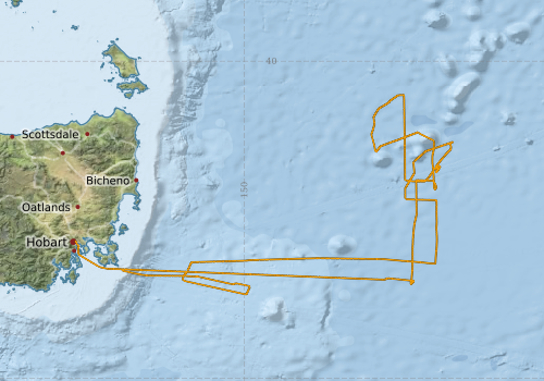
From: Hobart To: Hobart
Ship: Investigator (RV) [details]
Description: The primary voyage objective for this voyage, is for the Marine National Facility (MNF) to calibrate and commission new, upgraded and existing critical equipment (with sea trials and personnel training) onboard RV Investigator for upcoming voyages in the 2021 schedule and beyond.
Leader: Jason Fazey
Project: Investigator - general vessel operations, gear trials, etc. [details] Primary
Underway data from NRUD - see this voyage
Voyage extents: 43° 40.7' S to 40° 31.7' S 147° 19.8' E to 153° 17.7' E Get voyage track shapefile Get CSV
Marlin Metadata:-
Cruise Summary Report at SeaDataNet:-
Participants - on ship:-
| Name | Role | Organisation | Project |
|---|---|---|---|
| Jason Fazey | Chief Scientist | CSIRO National Collections and Marine Infrastructure | Investigator - general vessel operations, gear trials, etc. |
| Nicole Morgan | SIT Support | CSIRO National Collections and Marine Infrastructure | Seagoing Instrumentation Team |
Participants - shore based:-
| Name | Role | Organisation | Project |
|---|---|---|---|
| Craig Neill | PI - piggyback |
This list includes those that may have only been on part of the voyage. See voyage reports on 'Reports and Maps' tab for details.
Marine National Facility Reports - plans, summaries and data processing
-
IN2021_E02 Voyage Plan
- includes objectives, investigator details, proposed data collection, voyage track and equipment to be used.
-
IN2021_E02 Voyage Summary
- includes preliminary results, voyage narrative, types of data collected with C77/ROSCOP codes.
-
IN2021_E02 ADCP Data Processing Report
- details of data processing steps, calibration information, instruments used and any issues with the data.
- View Survey map
Publications, reports and datasets from this voyage.
Dataset
- Fazey, Jason; Boyd, Matt; Navidad, Cisco; Taylor, Charlie; Plunkett, Tom (2022): IN2021_E02 Freycinet Marine Park Bathymetry 5m - 210m Multi-resolution AusSeabed products. v1. CSIRO. Data Collection. 10.25919/myks-3r77
- Tilbrook, Bronte; Neill, Craig; Akl, John (2022). Integrated Marine Observing System (IMOS) sea surface and atmospheric fCO2 measurements in the Southern Ocean, South Pacific, Indian Ocean onboard R/V Investigator in 2021 (NCEI Accession 0253535). [indicate subset used]. NOAA National Centers for Environmental Information. Dataset. 10.25921/thsr-dd03
Search for publications, reports and datasets from this and other voyages
Data publishing
This is a list of online datasets hosted by CSIRO. Other processed datasets hosted by collaborating organisations may be found on the 'Metadata' or "Reports, Publications and Maps' tab.
Use the Get data link on the right to extract data using the NCMI Data Trawler.
| Data Stream | Data Summary | Get data | ||||||||||
|---|---|---|---|---|---|---|---|---|---|---|---|---|
| ADCP Data |
|
Get Data from Trawler Download the os150nb NetCDF Data Download the os150nb webpy Plots Download the os75nb NetCDF Data Download the os75nb webpy Plots |
||||||||||
| Gravity Measurements |
|
Get Data from Trawler |
||||||||||
| Multibeam echosounder |
|
Get Data from Trawler |
||||||||||
| pCO2 |
|
External link - download datafile at IMOS Data fields and units document (.pdf) |
||||||||||
| Sub-bottom profiler |
|
Get Data from Trawler |
||||||||||
| Singlebeam echosounder |
|
Get Data from Trawler |
| ID | When (UTC) | Lat | Long | Instrument | Identifier | Action | Log | Subject / Comment |
|---|
Deployments by start time:- Click on column header to sort. Use link on 'Deployment' to see full details. Use the CSV button at the bottom to export data (tab delimited).
Search for deployments from this voyage and others
| Deployment | Operation | Station | Cast | Gear | Project | Start and end times | Start Location | End Location | Depth range | Max Depth | Description | |||
|---|---|---|---|---|---|---|---|---|---|---|---|---|---|---|
| ADCP Data [details] | Teledyne RDI ADCP 75 kHz | 2549 | 2021-11-20 02:10 | 2021-11-27 20:58 | -43.0180 | 147.3749 | -43.0585 | 147.3905 | 782 | |||||
| XBT Cast [details] | 2391 | 2021-11-22 13:34 | 1100.3 | |||||||||||
| XBT Cast [details] | 2391 | 2021-11-22 13:42 | 1100.3 | |||||||||||