Voyage details and related metadata, reports, events and data.
IN2017_C01
- is a Marine National Facility ![]() voyage
voyage
Title: Great Australian Bight deep water geological and benthic ecology program
Voyage details on MNF site: https://mnf.csiro.au/en/Voyages/IN2017_C01
Period: 2017-04-10 22:00 to 2017-04-27 22:00 UTC
Duration: 17.00 days
From: Hobart To: Hobart
Ship: Investigator (RV) [details]
Description: The voyage objectives are built around three main scientific objectives: * The benthic characterisation and sampling outcropping sedimentary rocks to aid understanding of modern seabed erosional mechanisms, sedimentary processes and paleoenvironmental reconstruction. * Benthic characterisation and sampling in areas of potential seepage to determine if fluid escape is occurring and the nature of the fluids and their relationship to the benthic fauna in these areas. * Sampling of benthic fauna over a large geographic area to establish deep water community structure and function and augment understandings gained from recent IN2015_C01 and IN2015_C02 voyages. Benthic characterisation of outcrop rocks and sampling of benthic fauna carry higher weight than that of the seep characterisation. The voyage plan includes more planned operations in each target area than can be achieved within the time allocations for the survey. Each of these target areas are ranked based on their importance in delivering on the scientific objectives. The survey will use a hierarchical design comprising seafloor mapping prior to seafloor sampling and limited water column characterisation. Seafloor mapping and water column characterisation 1. Hull mounted acoustic characterisation of the water column and seafloor over the target areas of interest. This activity will comprise the use of MBES, water column acoustic backscatter, single beam echo sounder, sub-bottom profiler and ADCP to determine processes occurring in the water column and map the seafloor and shallow subsurface geology. 2. Seafloor characterisation from the surface will be complemented with a limited number of tow camera to obtain video transects across the target area seafloor and overlying near bottom waters. Seafloor and water column sampling A number of sampling operations will be undertaken to describe the seafloor geology and benthic biota. Each sampling operation will differ dependant on sampling target, primarily based on substrate composition. For the soft substrate targets there will be a focus on grab samples whilst for the harder substrate types the focus will be on dredging. Sampling will be by: 1. Deployment of grab sampler to sample the surface sediment infauna, microbiology, hydrocarbon chemistry and physical properties. 2. Use of a beam trawl or Sherman sled to collect samples of benthic macro fauna over target areas. 3. Use of rock dredges to collects lithified sediments for description and detailed chemical analysis. 4. Limited collections of water column profile data including CTD, chemical sensor readings and associated water samples
Leader: Dr Asrar Talukder (CSIRO)
Projects:
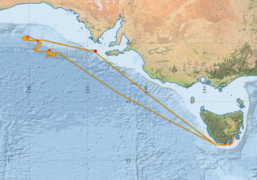
Voyage extents: 43° 42.4' S to 34° 23.8' S 129° 20.0' E to 147° 30.3' E Get voyage track shapefile Get CSV
Marlin Metadata:-
Metadata from OBIS Australia datasets:- biological data is published via the OBIS-AU IPT server and delivered to one or more of OBIS, ALA and GBIF
Download from OBIS Australia IPT View at - Ocean Biodiversity Information System (OBIS) Atlas of Living Australia (ALA) GBIF
Download from OBIS Australia IPT View at - Ocean Biodiversity Information System (OBIS) Atlas of Living Australia (ALA) GBIF
Download from OBIS Australia IPT View at - Ocean Biodiversity Information System (OBIS)
Download from OBIS Australia IPT View at - Ocean Biodiversity Information System (OBIS) Atlas of Living Australia (ALA) GBIF
Download from OBIS Australia IPT View at - Ocean Biodiversity Information System (OBIS) GBIF
Cruise Summary Report at SeaDataNet:-
Participants - on ship:-
| Name | Role | Organisation | Project |
|---|---|---|---|
| Alan Williams | Lead Investigator | CSIRO Oceans & Atmosphere - Hobart | RV Investigator Charter - Great Australian Bight Deepwater Marine Program |
| Asrar Talukder | Chief Scientist | CSIRO | RV Investigator Charter - Great Australian Bight Deepwater Marine Program |
| Charlotte Stalvies | Geology | CSIRO | RV Investigator Charter - Great Australian Bight Deepwater Marine Program |
| Tegan Sime | Voyage Manager | Marine National Facility | Voyage Management on RV Investigator |
Participants - shore based:-
| Name | Role | Organisation | Project |
|---|---|---|---|
| Andrew Ross | Principal Investigator | CSIRO | RV Investigator Charter - Great Australian Bight Deepwater Marine Program |
| Nick Hardman-Mountford | Piggy-back, Bio-Argo floats | CSIRO Oceans & Atmosphere - Hobart | Bio Argo float deployment in the Great Australian Bight |
This list includes those that may have only been on part of the voyage. See voyage reports on 'Reports and Maps' tab for details.
Marine National Facility Reports - plans, summaries and data processing
-
IN2017_C01 Voyage Plan
- includes objectives, investigator details, proposed data collection, voyage track and equipment to be used.
-
IN2017_C01 Scientific Highlights
- report of the key outputs
-
IN2017_C01 Voyage Summary
- includes preliminary results, voyage narrative, types of data collected with C77/ROSCOP codes.
-
IN2017_C01 Underway data Processing Report
- details of data processing steps, calibration information, instruments used and any issues with the data.
-
IN2017_C01 CTD data Processing Report
- details of data processing steps, calibration information, instruments used and any issues with the data.
-
IN2017_C01 HYD Process Report
- details of data processing steps, calibration information, instruments used and any issues with the data.
-
IN2017_C01 ADCP Data Processing Report
- details of data processing steps, calibration information, instruments used and any issues with the data.
- There is no map for this survey. Create a map from underway data.
Publications, reports and datasets from this voyage.
Dataset
- Appleyard, Sharon; Ward, Robert; Pogonoski, John; Graham, Alastair; Last, Peter; Deagle, Bruce; & Holmes, Bronwyn (2024): Marine fishes (from Australia) COI barcode reference library. v2. CSIRO. Data Collection. 10.25919/8haz-aa91
- Bakker, Dorothee C E; Lauvset, Siv K; Wanninkhof, Rik; Castaño-Primo, Rocío; Currie, Kim I; Jones, Steve D; Landa, Camilla S; Metzl, Nicolas; Nakaoka, Shin-Ichiro; Nojiri, Yukihiro; Nonaka, Isao; O'Brien, Kevin M; Olsen, Are; Pfeil, Benjamin; Pierrot, Denis; Schuster, Ute; Smith, Karl; Sullivan, Kevin; Sutton, Adrienne; Tilbrook, Bronte; Alin, Simone; Becker, Meike; Benoit-Cattin, Alice; Bott, Randy; Bozec, Yann; Bozzano, Roberto; Burger, Eugene; Burgers, Tonya; Cai, Wei-Jun; Chen, Liqi; Chierici, Melissa; Corredor, Jorge; Cosca, Catherine E; Cross, Jessica; Dandonneau, Yves; De Carlo, Eric Heinen; Dietrich, Colin; Else, Brent G T; Emerson, Steven R; Farías, Laura; Fransson, Agneta; Garreaud, René D; Gkritzalis, Thanos; Glockzin, Michael; González-Dávila, Melchor; Gregor, Luke; Hartman, Sue E; Hermes, Rudolf; Hoppema, Mario; Howden, Stephan; Hunt, Christopher W; Hydes, David; Ibánhez, J Severino P; Kitidis, Vassilis; Körtzinger, Arne; Kozyr, Alexander; Kuwata, Akira; Lampitt, Richard Stephen; Lefèvre, Nathalie; Lo Monaco, Claire; Maenner, Stacy M; Manke, Ansley; Manzello, Derek P; McGillis, Wade; Mickett, John; Monteiro, Pedro M S; Morell, Julio; Morrison, Ru; Mucci, Alfonso; Munro, David R; Musielewicz, Sylvia; Negri, Ruben M; Newberger, Timothy; Newton, Jan; Noakes, Scott; O'Brien, Chris; Ólafsdóttir, Sólveig Rósa; Ólafsson, Jón; Ono, Tsuneo; Osborne, John; Ouyang, Zhangxian; Padín, Xose Antonio; Papakyriakou, Tim N; Plüddemann, Albert J; Rehder, Gregor; Sabine, Christopher L; Sakurai, Keizo; Salisbury, Joe; Santana-Casiano, Juana Magdalena; Schlitzer, Reiner; Schneider, Bernd; Send, Uwe; Skjelvan, Ingunn; Steinhoff, Tobias; Sulpis, Olivier; Sutherland, Stewart C; Sweeney, Colm; Tadokoro, Kazuaki; Takahashi, Taro; Telszewski, Maciej; Thomas, Helmuth; Tomlinson, Michael; Trull, Tom W; Valdimarsson, Héðinn; van Heuven, Steven; Vandemark, Doug; Wada, Chisato; Wallace, Douglas WR; Watson, Andrew J; Weller, Robert A; Xu, Suqing (2018): Surface Ocean CO2 Atlas (SOCAT) V6. PANGAEA 10.1594/PANGAEA.890974
- Tilbrook, Bronte; Neill, Craig; Akl, John (2017). Integrated Marine Observing System (IMOS) sea surface and atmospheric fCO2 measurements in the Southern Ocean onboard R/V Investigator in 2017 (NCEI Accession 0169488). [indicate subset used]. NOAA National Centers for Environmental Information. Dataset. 10.7289/v5rv0kz4
IPT Resource
- Australian National Fish Collection (ANFC) (Darwin Core Archive) External link to reference
- CSIRO Marine Invertebrate Image Collection (MIIC) (Darwin Core Archive) External link to reference
- Global benthic biogeographical regions and macroecological drivers for ophiuroids [Data set] (Darwin Core Archive) External link to reference
- Great Australian Bight Research Program, Australia (2015-2017) (Darwin Core Archive) External link to reference
- New species of Laetmonice (Aphroditidae, Annelida) from bathyal and abyssal depths around Australia (2015-2022) (Darwin Core Archive) External link to reference
Journal Article
- Asrar Talukder, A., Ross, A. S., Trefry, C., Pickard, A., Tam, T. (2021). Understanding large scale seabed processes in a deep cool water carbonate ramp system: A case study of the Great Australian Bight. Marine and Petroleum Geology,Volume 125, 10.1016/j.marpetgeo.2020.104793
- Criscione, Francesco,Hallan, Anders (2025) Addressing knowledge gaps in the systematics of temperate south-east Australian deep-sea Raphitomidae (Caenogastropoda: Conoidea): integrative taxonomy of species of less diverse and taxonomically problematic genera. Invertebrate Systematics 39 pp-. 10.1071/is24089
- Daneliya, Mikhail E. (2023) Mysid subfamily Boreomysinae (Crustacea: Mysida: Mysidae) in the southeast Australian deep-sea. Records of the Australian Museum 75 pp87-124. 10.3853/j.2201-4349.75.2023.1845
- EKINS, MERRICK,ERPENBECK, DIRK,GOUDIE, LISA,HOOPER, JOHN N.A. (2020) New carnivorous sponges and allied species from the Great Australian Bight. Zootaxa 4878 pp-. 10.11646/zootaxa.4878.2.2
- Farrelly, C A., Ahyong, S T. (2019) Deepwater decapod, stomatopod and lophogastrid Crustacea from Eastern Australia and the Great Australian Bight collected in 2015–2017: preliminary identifications of 191 species. Museum Victoria Science Reports, 21, pp 1-97. 10.24199/j.mvsr.2019.21
- Flaxman, Beth,Kupriyanova, Elena (2024) New species of Laetmonice (Aphroditidae, Annelida) from bathyal and abyssal depths around Australia. Records of the Australian Museum 76 pp195-210. 10.3853/j.2201-4349.76.2024.1900
- Kantor, Yuri,Hallan, Anders,Criscione, Francesco (2022) Integrative taxonomy reveals new Australian species of the deep-water snail genera (Conoidea: Cochlespiridae) and (Conoidea: Pseudomelatomidae). Molluscan Research 42 pp229-247. 10.1080/13235818.2022.2102887
- Lucieer, Vanessa,Flukes, Emma,Monk, Jacquomo,Walsh, Peter (2024) Geomorphometric maps of Australia’s Marine Park estate and their role in improving the integrated monitoring and management of marine ecosystems. Frontiers in Marine Science 10 pp-. 10.3389/fmars.2023.1302108
- Nielsen, Jorgen; Pogonoski, John; Appleyard, Sharon. (2019) Aphyonid-clade species of Australia (Teleostei, Bythitidae) with four species new to Australian waters and a new species of Barathronus. Zootaxa. 2019; 4564(2):554-572. 10.11646/zootaxa.4564.2.12
- O'Hara, Timothy D.,Williams, Alan,Althaus, Franziska,Ross, Andrew S.,Bax, Nicholas J.,Pirotta, Enrico (2020) Regional-scale patterns of deep seafloor biodiversity for conservation assessment. Diversity and Distributions 26 pp479-494. 10.1111/ddi.13034
- Paxton, Hannelore,Budaeva, Nataliya,Gunton, Laetitia M. (2023) Amazing diversity of Nothria (Annelida, Onuphidae) in the Australian deep sea. Records of the Australian Museum 75 pp215-247. 10.3853/j.2201-4349.75.2023.1802
- Schinteie, Richard,Ross, Andrew S.,Boreham, Christopher J.,Kempton, Richard H.,Talukder, Asrar,Trefry, Christine (2023) Petroleum source rocks in the Bight Basin, Australia: An updated view. Marine and Petroleum Geology 151 pp106165-. 10.1016/j.marpetgeo.2023.106165
- Thiel, Ralf,Christodoulou, Magdalini,Pogonoski, John J.,Appleyard, Sharon A.,Weddehage, Thilo,Vink, Annemiek,Uhlenkott, Katja,Martinez Arbizu, Pedro (2022) An application of morphological analysis and DNA barcoding to identify Ipnops from the Clarion-Clipperton Zone (CCZ) as I. meadi Nielsen, 1966 with notes on other species of the genus (Aulopiformes: Ipnopidae). Marine Biodiversity 52 pp-. 10.1007/s12526-022-01320-1
- Zhang, Haifeng,Beggs, Helen,Griffin, Christopher,Govekar, Pallavi Devidas (2023) Validation of Himawari-8 Sea Surface Temperature Retrievals Using Infrared SST Autonomous Radiometer Measurements. Remote Sensing 15 pp2841-. 10.3390/rs15112841
Report
- Kempton, R., Ross, A., Trefry, C., Talukder, A., Pickard, A., Gong, S., Schinteie, R., and Stalvies, C. (Eds). (2018) Characterisation of outcropping rocks in the Great Australian Bight and interpretation of their source rock potential. Findings from the Great Australian Bight Deepwater Marine Program. Project 2. Source Rocks of the GAB. Report to Chevron Australia, Commercial-in Confidence. 8th of June, 2018. Pp 410.
- Ross, A., Kempton, R., Trefry, C., Parr, J., Pickard, A., Reynolds, P., Holford, S. and Williams, A. (2018) The distribution, formation and evolution of volcanics in the Great Australian Bight, Findings from the Great Australian Bight Deepwater Marine program, Project 5: Understanding GAB volcanic distribution and character. Commercial-in-confidence report to Chevron Australia Pty. Ltd. 389pp. CSIRO report.
- Ross, A., Trefry, C., Talukder, A., Stalvies, C. and Williams, A. (2018) Data collection and sample analysis methods utilised during the GABDMP seasons 1 and 2 voyages. Contributing report to milestone tasks 2.3.2, 3.4.2, 5.6. Commercial-in-confidence report to Chevron Australia Pty. Ltd. CSIRO, Australia.
Search for publications, reports and datasets from this and other voyages
Data publishing
This is a list of online datasets hosted by CSIRO. Other processed datasets hosted by collaborating organisations may be found on the 'Metadata' or "Reports, Publications and Maps' tab.
Use the Get data link on the right to extract data using the NCMI Data Trawler.
| Data Stream | Data Summary | Get data | ||||||||||
|---|---|---|---|---|---|---|---|---|---|---|---|---|
| ADCP Data |
|
Get Data from Trawler Download ADCP Data (NetCDF, 5 minute) |
||||||||||
| Marine biodiversity observations and/or samples |
|
Get Data from Trawler |
||||||||||
| Catch Details |
|
Get Data from Trawler |
||||||||||
| CTD profile |
|
Get Data from Trawler Download the CTD Data (netcdf) in2017_c01CTDAvg_nc.zip Download the CTD Data (.mat): in2017_c01CTDAvg_mat.zip Download the CTD Data (csv) in2017_c01CTDAvg_csv.zip |
||||||||||
| Gravity Measurements |
|
Get Data from Trawler Geophysical Survey and Mapping acquisition report |
||||||||||
| Hydrology |
|
Get Data from Trawler Download CSV Dataset: in2017_c01_Hydro_Deployments_CSV.zip Download the netcdf dataset: in2017_c01HYD_nc.zip |
||||||||||
| Multibeam echosounder |
|
Get Data from Trawler |
||||||||||
| pCO2 |
|
External link - download datafile at IMOS Data fields and units document (.pdf) |
||||||||||
| Radon measurements |
|
Get Data from Trawler Download RV Investigator Radon dataset (XLSX) |
||||||||||
| Sub-bottom profiler |
|
Get Data from Trawler Geophysical Survey and Mapping data acquisition and processing report |
||||||||||
| Singlebeam echosounder |
|
Get Data from Trawler Geophysical Survey and Mapping acquisition report |
||||||||||
| SOOP Bio-acoustics |
|
External link
Transect 2 - datafile at IMOS NetCDF Data Format: Manual Download |
||||||||||
| Sea Surface Temperature |
|
Get Data from Trawler Download IN2017_C01 compressed dataset (2.9 Mb) |
||||||||||
| XBT Profile |
|
Get Data from Trawler Geophysical Survey and Mapping data acquisition and processing report |
Caveat: this event log was authored on the voyage using either a standalone logging system called ELOG or more recently an inhouse event logging tool called Everlog. For this reason, some positions are unknown and may be resolved using the logged time and the underway dataset for the voyage.
Search for events from this voyage and others
| When (UTC) | Latitude | Longitude | Instrument | Identifier | Action | Log | Subject / Comments |
|---|---|---|---|---|---|---|---|
| 2017-04-04 12:57 [view ] | -42.8863 | 147.3388 | TSG [view] | restarted | in2017_c01 | TSG Restarted | |
| 2017-04-11 00:06 [view ] | -42.9960 | ADCP [view] | Start | in2017_c01 | only 75 (150 still out of service) | ||
| 2017-04-11 07:36 [view ] | -42.9317 | 147.3818 | SBP [view] | Start | GSM_in2017_c01 | Start pinging and logging SBP120 Ricker Pulse -20dB | |
| 2017-04-11 07:36 [view ] | -42.9317 | 147.3818 | Gravity Meter [view] | Start | GSM_in2017_c01 | gravity logging on departure | |
| 2017-04-11 07:48 [view ] | -42.9647 | 147.3777 | EM710 [view] | Start | GSM_in2017_c01 | still in derwent start logging EM710 data | |
| 2017-04-11 07:57 [view ] | -43.7045 | 146.1010 | EK60 [view] | Start | GSM_in2017_c01 | Start pinging and logging EK60 | |
| 2017-04-11 12:02 [view ] | -43.2663 | 145.1715 | Gravity Meter [view] | warning | GSM_in2017_c01 | had frozen with 'labview file opening permission error' | |
| 2017-04-11 12:22 [view ] | -43.2267 | 145.0942 | EK60 [view] | Other | GSM_in2017_c01 | Chief scientist requested full depth EK18 and 38 data recorded | |
| 2017-04-11 12:52 [view ] | -43.1680 | 144.9800 | EM122 [view] | SVP | GSM_in2017_c01 | updated svp to in2017_c01_sst05.asvp | |
| 2017-04-11 14:04 [view ] | -43.3502 | 147.4587 | SBP [view] | GSM_in2017_c01 | Stop logging SBP120 Poor quality | ||
| 2017-04-11 14:39 [view ] | -42.9542 | 144.5647 | Gravity Meter [view] | warning | GSM_in2017_c01 | labview warning again | |
| 2017-04-11 14:44 [view ] | -42.9438 | 144.5448 | EM122 [view] | SVP | GSM_in2017_c01 | updates svp to in2017_c01_sst06.asvp | |
| 2017-04-11 14:51 [view ] | -43.5062 | 147.4085 | SBP [view] | GSM_in2017_c01 | Start pinging and logging SBP120 linear chrip up -20dB | ||
| 2017-04-11 16:34 [view ] | -43.6535 | 147.0085 | EK60 [view] | Other | GSM_in2017_c01 | Change from active to passive | |
| 2017-04-11 20:19 [view ] | -43.6928 | 146.0053 | Gravity Meter [view] | Other | GSM_in2017_c01 | locked file warning - | |
| 2017-04-11 21:05 [view ] | -43.6020 | 145.8272 | EK60 [view] | Other | GSM_in2017_c01 | switched to deep mode | |
| 2017-04-11 21:05 [view ] | -43.6010 | 145.8252 | EM710 [view] | SVP | GSM_in2017_c01 | updates svp to in2017_c01_sst02.asvp | |
| 2017-04-11 21:07 [view ] | -43.5975 | 145.8182 | EM122 [view] | Start | GSM_in2017_c01 | start logging - svp in2017_c01_sst02 | |
| 2017-04-11 21:33 [view ] | -43.5483 | 145.7223 | EM710 [view] | Stop | GSM_in2017_c01 | stop logging em710 depth over 900 m | |
| 2017-04-11 22:36 [view ] | -42.0102 | 142.7488 | Temperature probe | SIT | Fault | in2017_c01 | STBD probe still faulty, flagged for replacement post v02, waiting on calibrated replacement to return |
| 2017-04-11 23:58 [view ] | -41.8503 | 142.4395 | EM122 [view] | Stop | GSM_in2017_c01 | restarted EM122 | |
| 2017-04-12 00:45 [view ] | -41.7572 | 142.2638 | EM122 [view] | SVP | GSM_in2017_c01 | Changed svp back to in2017_c01_sst6 sst 7 and sst 8 incorrect for lines 20 and 21 | |
| 2017-04-12 01:27 [view ] | -41.6718 | 142.1048 | EM122 [view] | Start | GSM_in2017_c01 | Start logging WC | |
| 2017-04-12 03:31 [view ] | -41.4223 | 141.6318 | EM122 [view] | Start | GSM_in2017_c01 | Restarted EM122 problems with qinsy | |
| 2017-04-12 04:45 [view ] | -41.2733 | 141.3502 | ADCP [view] | Change | in2017_c01 | os75 taken out of bottom track mode | |
| 2017-04-12 04:46 [view ] | -41.2720 | 141.3477 | EM122 [view] | SVP | GSM_in2017_c01 | updates svp to in2017_c01_sst07.asvp aml was not in configuration for ksync - redid sst07 | |
| 2017-04-12 05:33 [view ] | -41.2167 | 141.2428 | Other [view] | Other | GSM_in2017_c01 | slowed down to test usbl | |
| 2017-04-12 06:26 [view ] | -41.1338 | 141.0872 | EM122 [view] | SVP | GSM_in2017_c01 | asvp file in2017_c01_sst08 also back to deep mode as very deep had less coverage | |
| 2017-04-12 07:05 [view ] | -41.0548 | 140.9385 | EM122 [view] | SVP | GSM_in2017_c01 | in2017_c01_sst08.asvp | |
| 2017-04-12 07:49 [view ] | -40.9660 | 140.7715 | EM122 [view] | SVP | GSM_in2017_c01 | in2017_c01_sst10 | |
| 2017-04-12 08:31 [view ] | -40.8802 | 140.6105 | Gravity Meter [view] | Other | GSM_in2017_c01 | froze with labview error Karl will diable delta | |
| 2017-04-12 10:45 [view ] | -40.6168 | 140.1173 | EM122 [view] | SVP | GSM_in2017_c01 | in2017_c01_sst11.asvp | |
| 2017-04-12 12:32 [view ] | -40.4050 | 139.7222 | EM122 [view] | SVP | GSM_in2017_c01 | in2017_c01_sst12 | |
| 2017-04-13 04:07 [view ] | -38.5587 | 136.5438 | EM122 [view] | SVP | GSM_in2017_c01 | in2017_c01_sst13 | |
| 2017-04-13 07:09 [view ] | -38.1530 | 135.9363 | EM122 [view] | SVP | GSM_in2017_c01 | in2017_c01_sst14 | |
| 2017-04-13 11:28 [view ] | -37.5750 | 135.0767 | EM122 [view] | SVP | GSM_in2017_c01 | in2017_c01_sst15 | |
| 2017-04-13 15:36 [view ] | -37.0103 | 134.2432 | EM122 [view] | SVP | GSM_in2017_c01 | in2017_c01_sst16.asvp | |
| 2017-04-13 20:01 [view ] | -36.4207 | 133.3795 | EM122 [view] | SVP | GSM_in2017_c01 | Changed svp to in2017_c01_sst17 sal= 35.62 | |
| 2017-04-13 20:50 [view ] | -36.3142 | 133.2242 | XBT [view] | Drop | GSM_in2017_c01 | ||
| 2017-04-13 21:02 [view ] | -36.2865 | 133.1840 | EM122 [view] | SVP | GSM_in2017_c01 | Changed svp to in2017_c01_xbt1 sal= 35.38 | |
| 2017-04-14 00:21 [view ] | -35.8457 | 132.5587 | K-Sync [view] | Other | GSM_in2017_c01 | Changed depth mode to deep | |
| 2017-04-14 00:22 [view ] | -35.8437 | 132.5557 | EM122 [view] | Depth Mode | GSM_in2017_c01 | Changed depth mode to deep | |
| 2017-04-14 00:26 [view ] | -35.8343 | 132.5430 | Other [view] | Start | in2017_c01 | Arrived at site OR21 | |
| 2017-04-14 00:47 [view ] | -35.8072 | 132.4865 | EM122 [view] | SVP | GSM_in2017_c01 | Changed svp to in2017_c01_sst18 sal= 35.21 | |
| 2017-04-14 01:28 [view ] | -35.7897 | 132.3782 | EM122 [view] | SVP | GSM_in2017_c01 | Changed svp to in2017_c01_sst19 sal= 35.16 | |
| 2017-04-14 03:18 [view ] | -35.9823 | 132.3398 | XBT [view] | GSM_in2017_c01 | XBT Drop in2017_c01_xbt2 svp changed line 0086 | ||
| 2017-04-14 03:34 [view ] | -36.0123 | 132.3595 | EM122 [view] | GSM_in2017_c01 | Changed SVP to in2016_c01_sst019.asvp | ||
| 2017-04-14 03:39 [view ] | -36.0215 | 132.3542 | EM122 [view] | SVP | GSM_in2017_c01 | Changed SVP to in2017_c01_xbt2.asvp | |
| 2017-04-14 05:51 [view ] | -35.9167 | 132.0482 | EM122 [view] | SVP | GSM_in2017_c01 | in2017_c01_sst20.asvp xbt 3 ok but svpbuilder profile unusable | |
| 2017-04-14 08:38 [view ] | -35.9608 | 131.8058 | EM122 [view] | SVP | GSM_in2017_c01 | in2017_c01_xbt04.asvp | |
| 2017-04-14 09:42 [view ] | -36.0022 | 131.9682 | EM122 [view] | GSM_in2017_c01 | angles from 75 to 60 | ||
| 2017-04-14 09:42 [view ] | -36.0027 | 131.9698 | EM122 [view] | SVP | GSM_in2017_c01 | in2017_c01_sst21.asvp | |
| 2017-04-14 10:58 [view ] | -36.0890 | 132.1357 | EM122 [view] | Line | GSM_in2017_c01 | data from alan up to here | |
| 2017-04-14 13:14 [view ] | -36.0488 | 131.8015 | Other [view] | Other | GSM_in2017_c01 | change ship speed to 7 knots | |
| 2017-04-14 13:43 [view ] | -36.0283 | 131.7342 | EM122 [view] | SVP | GSM_in2017_c01 | in2017_c01_sst23.asvp | |
| 2017-04-14 21:46 [view ] | -35.9577 | 131.8912 | EM122 [view] | SVP | GSM_in2017_c01 | Changed svp to in2017_c01_sst24 sal= 35.16 | |
| 2017-04-14 22:30 [view ] | -35.9948 | 131.9620 | Dredge | 1 | Deployed | in2017_c01 | |
| 2017-04-15 01:30 [view ] | -35.9618 | 131.9963 | Dredge | Retrieved | in2017_c01 | ||
| 2017-04-15 12:23 [view ] | -35.8155 | 132.0207 | Other [view] | GSM_in2017_c01 | off em122 SBP120 pinging off so usbl return maximised - ek60 as well | ||
| 2017-04-15 17:49 [view ] | -35.8797 | 131.9350 | EM122 [view] | Start | GSM_in2017_c01 | Start pinging and logging EM122 | |
| 2017-04-15 18:00 [view ] | -35.8792 | 131.9347 | SBP [view] | Start | GSM_in2017_c01 | Start pinging and logging SBP120 | |
| 2017-04-15 18:01 [view ] | -35.8792 | 131.9347 | EK60 [view] | Start | GSM_in2017_c01 | Start pinging and logging EK60 | |
| 2017-04-15 18:30 [view ] | -35.8805 | 131.9058 | SBP [view] | Other | GSM_in2017_c01 | Parameter change Changed pulse length from 6ms to 20ms and from normal transmit cycle to burst | |
| 2017-04-15 18:34 [view ] | -35.8805 | 131.8927 | Beam Trawl [view] | Retrieved | in2017_c01 | ||
| 2017-04-15 19:02 [view ] | -35.8852 | 131.7803 | SBP [view] | Other | GSM_in2017_c01 | Changed trace size to variable | |
| 2017-04-15 19:41 [view ] | -35.8918 | 131.6585 | SBP [view] | Other | GSM_in2017_c01 | Changed to normal and pulse length 6ms | |
| 2017-04-15 20:41 [view ] | -35.8875 | 131.6618 | EM122 [view] | Stop | GSM_in2017_c01 | Stop logging EM122 Dredge-3 | |
| 2017-04-15 20:45 [view ] | -35.8875 | 131.6618 | Dredge | 2 | Deployed | in2017_c01 | |
| 2017-04-16 00:49 [view ] | -35.8633 | 131.6640 | EM122 [view] | Start | GSM_in2017_c01 | Start logging EM122 | |
| 2017-04-16 00:52 [view ] | -35.8709 | 131.6546 | Other [view] | Fault | in2017_c01 | Restarted rappFish.py - hung with ZMQError: Too many open files zmq/backend/cython/socket.pyx line 227 | |
| 2017-04-16 01:49 [view ] | -35.8962 | 131.6343 | EM122 [view] | Stop | GSM_in2017_c01 | Stop logging EM122 Dredge 4 | |
| 2017-04-16 04:50 [view ] | -35.8350 | 131.6638 | Techsas1 [view] | restarted | in2017_c01 | 2ndry GPS driver restarted on techsas1&2 | |
| 2017-04-16 05:00 [view ] | -35.8322 | 131.6642 | EM122 [view] | Start | GSM_in2017_c01 | restart logging - moving to beam trawl 178 site | |
| 2017-04-16 11:57 [view ] | -35.7720 | 131.7648 | EM122 [view] | SVP | GSM_in2017_c01 | in2017_c01_sst26.asvp restart logging between beam trawls | |
| 2017-04-16 12:43 [view ] | -35.7727 | 131.7725 | EM122 [view] | Start | GSM_in2017_c01 | start logging for a bit - with asvp created by doris not sure how to change salinity from 35 - edited out top values to 6 metres | |
| 2017-04-16 16:10 [view ] | -35.8290 | 131.6745 | EK60 [view] | Stop | GSM_in2017_c01 | Stop pinging and logging EK60 | |
| 2017-04-16 16:11 [view ] | -35.8290 | 131.6743 | SBP [view] | Stop | GSM_in2017_c01 | Stop pinging and logging SBP120 | |
| 2017-04-16 19:45 [view ] | -35.8633 | 131.5945 | EK60 [view] | Start | GSM_in2017_c01 | Start pinging and logging Ek60 finished beam trawl | |
| 2017-04-16 19:46 [view ] | -35.8633 | 131.5938 | EM122 [view] | Start | GSM_in2017_c01 | Start pinging and logging EM122 | |
| 2017-04-16 20:14 [view ] | -35.8670 | 131.5772 | SBP [view] | Start | GSM_in2017_c01 | Start pinging and logging SBP120 Source power -20dB pulse length 6ms | |
| 2017-04-16 22:08 [view ] | -35.6017 | 131.7615 | SBP [view] | Stop | GSM_in2017_c01 | Stop logging SBP120 CTD site | |
| 2017-04-16 22:26 [view ] | -35.6012 | 131.7602 | EM122 [view] | Stop | GSM_in2017_c01 | Stop logging EM122 at CTD site | |
| 2017-04-16 22:38 [view ] | -35.6010 | 131.7595 | CTD [view] | Deployed | in2017_c01 | ||
| 2017-04-16 22:54 [view ] | -35.6008 | 131.7590 | SBP [view] | Start | GSM_in2017_c01 | Start logging SBP over CTD site | |
| 2017-04-16 23:59 [view ] | -35.6003 | 131.7577 | EM122 [view] | Start | GSM_in2017_c01 | Start logging EM122 | |
| 2017-04-17 00:07 [view ] | -35.5988 | 131.7575 | CTD [view] | 1 | Retrieved | in2017_c01 | |
| 2017-04-17 00:13 [view ] | -35.5955 | 131.7485 | ARGO float [view] | argo | Deployed | in2017_c01 | argo deployed |
| 2017-04-17 05:29 [view ] | -35.6980 | 130.6823 | EM122 [view] | SVP | GSM_in2017_c01 | in2017_c01_ctd001.asvp | |
| 2017-04-17 05:56 [view ] | -35.6823 | 130.5972 | SBP [view] | Line | GSM_in2017_c01 | 11 started for run up nullabor canyon | |
| 2017-04-17 05:57 [view ] | -35.6792 | 130.5970 | EM122 [view] | Line | GSM_in2017_c01 | new line for nullabor canyon transit | |
| 2017-04-17 07:45 [view ] | -35.3995 | 130.7193 | EM122 [view] | SVP | GSM_in2017_c01 | in2017_c01_sst28.asvp | |
| 2017-04-17 08:19 [view ] | -35.3115 | 130.7660 | EM122 [view] | SVP | GSM_in2017_c01 | in2017_c01_xbt06.asvp created with doris - svpbuilder incorporating bad data - constant salinity 35- edit top velocity | |
| 2017-04-17 12:02 [view ] | -35.4892 | 130.3777 | EM122 [view] | Stop | GSM_in2017_c01 | listening for beacon on beam trawl | |
| 2017-04-17 12:02 [view ] | -35.4895 | 130.3775 | EK60 [view] | Stop | GSM_in2017_c01 | put 18kHz into passive to listen for beacon on beam trawl | |
| 2017-04-17 13:12 [view ] | -35.5155 | 130.3570 | SBP [view] | Stop | GSM_in2017_c01 | to listen for beacon on beam trawl | |
| 2017-04-17 14:07 [view ] | -35.5355 | 130.3400 | ADCP [view] | Stop | in2017_c01 | Logging stopped to test hydrophone | |
| 2017-04-17 15:28 [view ] | -35.5505 | 130.3175 | ADCP [view] | Start | in2017_c01 | Restarted logging | |
| 2017-04-17 15:51 [view ] | -35.5515 | 130.3132 | EK60 [view] | Start | GSM_in2017_c01 | all back on | |
| 2017-04-17 15:59 [view ] | -35.5517 | 130.3115 | EM122 [view] | SVP | GSM_in2017_c01 | in2017_c01_sst29.asvp - not pinging still on beam trawl | |
| 2017-04-17 16:20 [view ] | -35.5527 | 130.3068 | EM122 [view] | Start | GSM_in2017_c01 | Start pinging and logging EM122 | |
| 2017-04-17 16:21 [view ] | -35.5528 | 130.3065 | SBP [view] | Start | GSM_in2017_c01 | Start pinging and logging SBP120 | |
| 2017-04-17 18:15 [view ] | -35.5730 | 130.3325 | EM122 [view] | Other | GSM_in2017_c01 | Changed sounder settings Max coverage from 30000 to 2000 Angular coverage mode: change from auto to manual | |
| 2017-04-17 18:34 [view ] | -35.5850 | 130.3957 | EM122 [view] | SVP | GSM_in2017_c01 | Changed svp to in2017_c01_sst30 sal= 35.25 | |
| 2017-04-17 19:17 [view ] | -35.5567 | 130.5160 | EM122 [view] | Other | GSM_in2017_c01 | Change sounder settings Change max angle to 75 | |
| 2017-04-17 20:35 [view ] | -35.4435 | 130.6738 | SBP [view] | Other | GSM_in2017_c01 | Changed to fixed rate | |
| 2017-04-17 21:38 [view ] | -35.2938 | 130.7755 | SBP [view] | Other | GSM_in2017_c01 | restart | |
| 2017-04-17 22:00 [view ] | -35.2487 | 130.7994 | Other [view] | Fault | in2017_c01 | Restarted rappFish.py - hung with ZMQError: Too many open files | |
| 2017-04-17 23:06 [view ] | -35.1120 | 130.8717 | EM122 [view] | SVP | GSM_in2017_c01 | Changed svp to in2017_c01_sst31 sal= 35.51 | |
| 2017-04-18 03:37 [view ] | -35.0140 | 130.9175 | TSG [view] | Out of Service | in2017_c01 | swapping out TSG for the spare unit due to intermittent restarts noted on the existing unit Spare unit does not seem to be operational. Sending spurious data. | |
| 2017-04-18 12:13 [view ] | -35.1012 | 130.8780 | EM122 [view] | Stop | GSM_in2017_c01 | to listen for usbl | |
| 2017-04-18 12:14 [view ] | -35.1018 | 130.8777 | EK60 [view] | Stop | GSM_in2017_c01 | put 18kHz in passive to listen for usbl | |
| 2017-04-18 14:48 [view ] | -35.1497 | 130.8398 | EM122 [view] | Start | GSM_in2017_c01 | lining up for rock dredge op 186 will restart sbp120 and ek60 | |
| 2017-04-18 16:07 [view ] | -35.1703 | 130.8123 | SBP [view] | GSM_in2017_c01 | Stopped logging SBP | ||
| 2017-04-18 17:02 [view ] | -35.1553 | 130.8143 | SBP [view] | Start | GSM_in2017_c01 | Start logging SBP | |
| 2017-04-18 19:17 [view ] | -35.1900 | 130.7707 | TSG [view] | SIT | Fault | in2017_c01 | Swapped out TSG TSG swapped for SBE21 2753 TSG 2567 not responding to deck unit |
| 2017-04-18 20:38 [view ] | -35.4065 | 130.6648 | Techsas2 [view] | restarted | in2017_c01 | interface froze while updating TSG configuration | |
| 2017-04-18 21:24 [view ] | -35.4027 | 130.6651 | TSG [view] | reset | in2017_c01 | Put spare unit in, testing of the original unit has generated bad data since about 18/4 03:37z | |
| 2017-04-19 04:17 [view ] | -34.8479 | 130.7807 | TSG [view] | noisy | in2017_c01 | Tested the TSG unit again. Bad data between 19/04 0417 and 19/4 08:59 | |
| 2017-04-19 05:18 [view ] | -34.7980 | 130.7108 | EM122 [view] | SVP | GSM_in2017_c01 | tried xbt09 from doris - data terrible back to in2017_c01_sst31.asvp | |
| 2017-04-19 06:04 [view ] | -34.7703 | 130.7123 | EM122 [view] | SVP | GSM_in2017_c01 | in2017_c01_032.asvp tsg back up - | |
| 2017-04-19 08:51 [view ] | -34.7525 | 130.7008 | AML | Other | GSM_in2017_c01 | tgriggering set to internal as not updating | |
| 2017-04-19 11:31 [view ] | -34.7745 | 130.7158 | EM122 [view] | SVP | GSM_in2017_c01 | in2017_c01_xbt_09_doris.asvp | |
| 2017-04-20 08:30 [view ] | -34.5523 | 129.4047 | EM122 [view] | SVP | GSM_in2017_c01 | in2017_c01_sst034.asvp | |
| 2017-04-20 12:23 [view ] | -34.5948 | 129.3853 | EM122 [view] | SVP | GSM_in2017_c01 | in2017_c01_xbt09_doris | |
| 2017-04-20 20:25 [view ] | -34.6692 | 129.6502 | SBP [view] | Stop | GSM_in2017_c01 | Stop pinging and logging SBP replaying SBP data for in2015_c01 to check settings - on way to dredge site, testing camera tow at present | |
| 2017-04-20 20:48 [view ] | -34.6577 | 129.6250 | SBP [view] | Start | GSM_in2017_c01 | Start pinging and logging SBP Changed settings to 0db and 11ms pulse length to match in2015_c01 | |
| 2017-04-20 21:00 [view ] | -34.6478 | 129.5858 | Towed Camera [view] | test | in2017_c01 | Test of deep towed platform to 600dbar, 1600 m wireout, fibre fault fixed platform working well | |
| 2017-04-21 09:05 [view ] | -34.4573 | 129.4680 | Other [view] | Stop | GSM_in2017_c01 | listening for usbl - stop EM122, sbp and ek60 | |
| 2017-04-21 12:01 [view ] | -34.4917 | 129.4737 | EM122 [view] | SVP | GSM_in2017_c01 | in2017_c01_xbt011.asvp | |
| 2017-04-21 13:40 [view ] | -34.5462 | 129.6052 | Other [view] | Other | GSM_in2017_c01 | stop em122 and ek60 pinging for usbl beacon | |
| 2017-04-21 16:08 [view ] | -34.5952 | 129.5455 | SBP [view] | Stop | GSM_in2017_c01 | stopped logging and pinging SBP | |
| 2017-04-21 17:36 [view ] | -34.5868 | 129.5428 | EM122 [view] | Start | GSM_in2017_c01 | Start pinging and logging EM122 Finished beam trawl | |
| 2017-04-21 17:36 [view ] | -34.5867 | 129.5445 | SBP [view] | Start | GSM_in2017_c01 | Start pinging and logging EM122 power 0dB and pulse length 11ms | |
| 2017-04-21 19:54 [view ] | -34.4480 | 129.8838 | EK60 [view] | Other | GSM_in2017_c01 | Change 18kHz to active all active apart from 18kHz | |
| 2017-04-21 20:51 [view ] | -34.4477 | 129.8832 | SBP [view] | Stop | GSM_in2017_c01 | Stop pinging and logging SBP While at dredge site | |
| 2017-04-22 00:20 [view ] | -34.4527 | 129.8885 | CTD [view] | 2 | Deployed | in2017_c01 | |
| 2017-04-22 01:55 [view ] | -34.4530 | 129.8812 | CTD [view] | Retrieved | in2017_c01 | ||
| 2017-04-22 02:30 [view ] | -34.4515 | 129.8830 | ADCP [view] | Stop | in2017_c01 | fault finding sources of interferance with sub bottom profiler | |
| 2017-04-22 02:38 [view ] | -34.4512 | 129.8837 | ADCP [view] | Start | in2017_c01 | testing over | |
| 2017-04-22 04:36 [view ] | -34.5875 | 130.2746 | EM122 [view] | SVP | GSM_in2017_c01 | in2017_c01_ctd_002.asvp | |
| 2017-04-22 07:06 [view ] | -34.7815 | 130.7323 | EM122 [view] | Start | GSM_in2017_c01 | new line for 2nd sweep over seep site VM04 | |
| 2017-04-22 10:02 [view ] | -34.7683 | 130.6895 | Other [view] | Start | GSM_in2017_c01 | em122 and ek60 not pinging - listening for usbl camera tow on vm04 | |
| 2017-04-22 14:15 [view ] | -34.7507 | 130.6857 | EM122 [view] | SVP | GSM_in2017_c01 | in2017_c01_xbt_013_build.asvp | |
| 2017-04-22 15:14 [view ] | -34.7643 | 130.7028 | Other [view] | Stop | GSM_in2017_c01 | em122 and ek60 18kHz off for usbl on camera tow 2 | |
| 2017-04-22 16:30 [view ] | -34.7933 | 130.7370 | EK60 [view] | Start | GSM_in2017_c01 | Change 18kHZ to active | |
| 2017-04-22 17:45 [view ] | -34.7877 | 130.7125 | Other [view] | Stop | GSM_in2017_c01 | Turned off EM122 EK60 and SBP for beam trawl | |
| 2017-04-22 20:31 [view ] | -34.7187 | 130.6880 | Other [view] | Start | GSM_in2017_c01 | Turned on SBP EK60 18khz active and EM122 end of beam trawl | |
| 2017-04-22 21:06 [view ] | -34.7502 | 130.7000 | Other [view] | Stop | GSM_in2017_c01 | Turned off EM122 EK60 18kHz (passive) and SBP start of beam trawl | |
| 2017-04-23 00:01 [view ] | -34.8003 | 130.6998 | EM122 [view] | Start | GSM_in2017_c01 | Start pinging and logging EM122 | |
| 2017-04-23 00:02 [view ] | -34.7977 | 130.6988 | SBP [view] | GSM_in2017_c01 | Start pinging and logging EM122 | ||
| 2017-04-23 00:02 [view ] | -34.7968 | 130.6987 | EK60 [view] | Start | GSM_in2017_c01 | Start pinging and logging EK60 | |
| 2017-04-23 00:49 [view ] | -34.6823 | 130.6517 | EM122 [view] | Stop | GSM_in2017_c01 | Stop pinging and logging EM122 for camera tow | |
| 2017-04-23 00:49 [view ] | -34.6823 | 130.6517 | EK60 [view] | Stop | GSM_in2017_c01 | EK60 18kHz into passive | |
| 2017-04-23 00:50 [view ] | -34.6823 | 130.6517 | SBP [view] | GSM_in2017_c01 | stop pinging and logging SBP | ||
| 2017-04-23 02:59 [view ] | -34.7812 | 130.6987 | EM122 [view] | GSM_in2017_c01 | Start pinging and logging EM122 | ||
| 2017-04-23 03:01 [view ] | -34.7830 | 130.6995 | SBP [view] | Start | GSM_in2017_c01 | Start pinging and logging SBP | |
| 2017-04-23 03:02 [view ] | -34.7833 | 130.6997 | EK60 [view] | Start | GSM_in2017_c01 | Change 18kHz to active | |
| 2017-04-23 10:47 [view ] | -34.8895 | 131.8635 | EK60 [view] | Other | GSM_in2017_c01 | back to imos 1500 m settings | |
| 2017-04-23 11:26 [view ] | -34.9248 | 132.0170 | EM710 [view] | Start | GSM_in2017_c01 | start pinging depth 1229 | |
| 2017-04-23 11:28 [view ] | -34.9275 | 132.0285 | EM122 [view] | SVP | GSM_in2017_c01 | in2017_c01_ctd_009.asvp | |
| 2017-04-23 18:52 [view ] | -35.3360 | 133.8128 | EM122 [view] | SVP | GSM_in2017_c01 | Changed svp to in2017_c01_sst28 sal= 35.91 should be sst36 - wrong name | |
| 2017-04-23 21:45 [view ] | -35.4950 | 134.5102 | EM122 [view] | SVP | GSM_in2017_c01 | Changed svp to in2017_c01_sst37 sal= 35.77 | |
| 2017-04-23 22:17 [view ] | -35.5238 | 134.6367 | XBT [view] | 14 | in2017_c01 | XBT drop in2017_c01_xbt14 | |
| 2017-04-23 22:19 [view ] | -35.5255 | 134.6440 | EM122 [view] | SVP | GSM_in2017_c01 | Changed svp to in2017_c01xbt14 at sal=35.35 | |
| 2017-04-23 23:11 [view ] | -35.5740 | 134.8570 | EM122 [view] | GSM_in2017_c01 | Change svp to in2017_c01_sst38 sal=35.76 | ||
| 2017-04-23 23:39 [view ] | -35.6008 | 134.9745 | EM122 [view] | SVP | GSM_in2017_c01 | Changed svp to in2017_c01_sst39 sal= 35.40 | |
| 2017-04-24 00:17 [view ] | -35.6368 | 135.1327 | EM710 [view] | Start | GSM_in2017_c01 | Start pinging and logging EM710 | |
| 2017-04-24 00:22 [view ] | -35.6410 | 135.1515 | K-Sync [view] | GSM_in2017_c01 | change from deep to intermediate | ||
| 2017-04-24 00:29 [view ] | -35.6475 | 135.1797 | EM710 [view] | Stop | GSM_in2017_c01 | restart | |
| 2017-04-24 00:36 [view ] | -35.6543 | 135.2098 | EM122 [view] | Depth Mode | GSM_in2017_c01 | changed to deep | |
| 2017-04-24 00:38 [view ] | -35.6560 | 135.2170 | K-Sync [view] | Other | GSM_in2017_c01 | Changed from shallow to intermediate | |
| 2017-04-24 01:22 [view ] | -35.5965 | 135.3842 | SBP [view] | GSM_in2017_c01 | changed to ricker pinging internally source power -30db | ||
| 2017-04-24 01:23 [view ] | -35.5952 | 135.3873 | EM710 [view] | Start | GSM_in2017_c01 | change from shallow to very shallow Started EM710 pinging internally | |
| 2017-04-24 01:25 [view ] | -35.5917 | 135.3950 | EM710 [view] | Start | GSM_in2017_c01 | start logging water column | |
| 2017-04-24 01:26 [view ] | -35.5900 | 135.3990 | XBT [view] | 15 | Deployed | in2017_c01 | deployed XBT15 |
| 2017-04-24 01:27 [view ] | -35.5883 | 135.4032 | EK60 [view] | Depth Mode | GSM_in2017_c01 | changed range to 250m | |
| 2017-04-24 01:31 [view ] | -35.5832 | 135.4150 | EM122 [view] | SVP | GSM_in2017_c01 | Changed svp to in2017_c01_xbt15 sal= 35.84 | |
| 2017-04-24 01:32 [view ] | -35.5822 | 135.4175 | EM710 [view] | SVP | GSM_in2017_c01 | Changed svp to in2017_c01_xbt15 sal= 35.84 | |
| 2017-04-24 03:13 [view ] | -35.6703 | 135.6777 | EM122 [view] | Stop | GSM_in2017_c01 | Stop logging and pinging EM122 at SZ12 site | |
| 2017-04-24 03:22 [view ] | -35.6787 | 135.7038 | ADCP [view] | Stop | in2017_c01 | ADCP stopped for swath line | |
| 2017-04-24 03:29 [view ] | -35.6838 | 135.7178 | EM710 [view] | SVP | GSM_in2017_c01 | Changed svp to in2017_c01_sst40 sal= 35.68 | |
| 2017-04-24 03:31 [view ] | -35.6868 | 135.7195 | EM710 [view] | Line | GSM_in2017_c01 | start line 3 At Site SZ12 finished line 1 | |
| 2017-04-24 03:34 [view ] | -35.6905 | 135.7155 | SBP [view] | GSM_in2017_c01 | start line 3 At Site SZ12 finished line 1 | ||
| 2017-04-24 05:34 [view ] | -35.5942 | 135.4192 | Other [view] | Start | GSM_in2017_c01 | sbp 32; em710 24 | |
| 2017-04-24 07:45 [view ] | -35.6802 | 135.6970 | Other [view] | Start | GSM_in2017_c01 | SBP 33; EM710 26 | |
| 2017-04-24 09:42 [view ] | -35.5907 | 135.4182 | Other [view] | Start | GSM_in2017_c01 | GSM 04 start; sbp 34; em710 line 29 | |
| 2017-04-24 11:39 [view ] | -35.6917 | 135.7192 | Other [view] | Start | GSM_in2017_c01 | end of gsm04 ; sbp 35; em122 31 | |
| 2017-04-24 11:44 [view ] | -35.6842 | 135.7113 | ADCP [view] | Start | in2017_c01 | ADCP logging resumed | |
| 2017-04-24 13:02 [view ] | -35.6793 | 135.6937 | EM710 [view] | Other | GSM_in2017_c01 | set power to -10 - what is causing interference in em710 | |
| 2017-04-24 18:56 [view ] | -35.5977 | 135.4300 | Other [view] | in2017_c01 | end of swath mapping - heading back to port | ||
| 2017-04-24 18:57 [view ] | -35.5975 | 135.4323 | EM710 [view] | GSM_in2017_c01 | ship speeding up to 12 knots end of swath mapping | ||
| 2017-04-25 00:52 [view ] | -36.4333 | 136.4740 | EK60 [view] | Depth Mode | GSM_in2017_c01 | Changed from 250m to 1500m | |
| 2017-04-25 00:52 [view ] | -36.4342 | 136.4752 | SBP [view] | Other | GSM_in2017_c01 | changed ping rate from fixed 200ms to 5000ms | |
| 2017-04-25 00:57 [view ] | -36.4463 | 136.4903 | EK60 [view] | Depth Mode | GSM_in2017_c01 | changed back to 250m range | |
| 2017-04-25 00:58 [view ] | -36.4477 | 136.4922 | SBP [view] | Other | GSM_in2017_c01 | changed ping rate to 2000ms | |
| 2017-04-25 02:07 [view ] | -36.6120 | 136.6972 | EK60 [view] | Depth Mode | GSM_in2017_c01 | Change depth to 1500m | |
| 2017-04-25 02:13 [view ] | -36.6257 | 136.7142 | EM710 [view] | Depth Mode | GSM_in2017_c01 | Changed to from very shallow to shallow | |
| 2017-04-25 02:16 [view ] | -36.6335 | 136.7240 | K-Sync [view] | GSM_in2017_c01 | changed from very shallow to shallow .. and then back to shallow | ||
| 2017-04-25 02:19 [view ] | -36.6405 | 136.7327 | EM710 [view] | Stop | GSM_in2017_c01 | stop WCL | |
| 2017-04-25 02:22 [view ] | -36.6462 | 136.7398 | EM710 [view] | GSM_in2017_c01 | changed to deep | ||
| 2017-04-25 02:23 [view ] | -36.6485 | 136.7428 | EM122 [view] | Start | GSM_in2017_c01 | Start pinging and logging EM122 changed to medium 0307 | |
| 2017-04-25 02:23 [view ] | -36.6497 | 136.7442 | EM710 [view] | Depth Mode | GSM_in2017_c01 | changed to vry deep | |
| 2017-04-25 02:25 [view ] | -36.6535 | 136.7490 | EM710 [view] | Stop | GSM_in2017_c01 | Stop logging and pinging EM710 | |
| 2017-04-25 02:27 [view ] | -36.6578 | 136.7545 | SBP [view] | GSM_in2017_c01 | Change to Linear chirp up power -30dB pulse length 6ms fixed rate 5000ms | ||
| 2017-04-25 02:32 [view ] | -36.6697 | 136.7692 | SBP [view] | Power | GSM_in2017_c01 | change source power to -20dB | |
| 2017-04-25 02:41 [view ] | -36.6910 | 136.7958 | Gravity Meter [view] | Stop | GSM_in2017_c01 | Gravity meter clamped and shut down for weather | |
| 2017-04-25 02:41 [view ] | -36.6920 | 136.7972 | EM122 [view] | Stop | GSM_in2017_c01 | Stop logging WCL | |
| 2017-04-25 02:46 [view ] | -36.7032 | 136.8112 | K-Sync [view] | Depth Mode | GSM_in2017_c01 | Change to intermediate | |
| 2017-04-25 02:47 [view ] | -36.7052 | 136.8137 | EM122 [view] | Depth Mode | GSM_in2017_c01 | Change to deep | |
| 2017-04-25 03:17 [view ] | -36.7737 | 136.8995 | EM122 [view] | SVP | GSM_in2017_c01 | Changed svp to in2017_c01_sst41 sal= 35.55 | |
| 2017-04-25 03:39 [view ] | -36.8257 | 136.9647 | SBP [view] | GSM_in2017_c01 | Stop logging SBP12-bad weather | ||
| 2017-04-25 04:43 [view ] | -36.9723 | 137.1487 | EM122 [view] | SVP | GSM_in2017_c01 | in2017_c01_sst41.asvp | |
| 2017-04-25 07:06 [view ] | -37.2978 | 137.5585 | SBP [view] | Stop | GSM_in2017_c01 | stop pinging - hasn't been recording for 2 hours | |
| 2017-04-25 09:13 [view ] | -37.5893 | 137.9272 | EM122 [view] | SVP | GSM_in2017_c01 | in2017_c01_sst43.asvp | |
| 2017-04-25 15:45 [view ] | -38.3860 | 138.9417 | EM122 [view] | SVP | GSM_in2017_c01 | Changed svp to in2017_c01_sst45 sal= 35.17 | |
| 2017-04-26 00:06 [view ] | -39.3475 | 140.1813 | EM122 [view] | SVP | GSM_in2017_c01 | Changed svp to in2017_c01_sst46 sal= 35.04 | |
| 2017-04-26 07:02 [view ] | -40.2103 | 141.3087 | EM122 [view] | SVP | GSM_in2017_c01 | in2017_c01_sst47.asvp | |
| 2017-04-26 09:11 [view ] | -40.4737 | 141.6555 | EM122 [view] | SVP | GSM_in2017_c01 | in2017_c01_sst48.asvp | |
| 2017-04-26 10:28 [view ] | -40.6352 | 141.8688 | EM122 [view] | SVP | GSM_in2017_c01 | in2017_c01_sst49.asvp | |
| 2017-04-26 12:41 [view ] | -40.9147 | 142.2395 | EM122 [view] | SVP | GSM_in2017_c01 | in2017_c01_sst50.asvp | |
| 2017-04-26 21:18 [view ] | -42.0607 | 143.7757 | EM122 [view] | SVP | GSM_in2017_c01 | Changed svp to in2017_c01_sst51 sal= 35.33 | |
| 2017-04-27 01:03 [view ] | -42.5542 | 144.4458 | EM122 [view] | SVP | GSM_in2017_c01 | Changed svp to in2017_c01_sst52 sal= 35.14 | |
| 2017-04-27 02:50 [view ] | -42.7967 | 144.7772 | EM122 [view] | SVP | GSM_in2017_c01 | Changed svp to in2017_c01_sst53 sal= 35.36 | |
| 2017-04-27 04:43 [view ] | -43.0627 | 145.1424 | ADCP [view] | Change | in2017_c01 | OS75 switched to bottom tracking | |
| 2017-04-27 04:57 [view ] | -43.0937 | 145.1848 | EM122 [view] | Stop | GSM_in2017_c01 | stop logging | |
| 2017-04-27 04:57 [view ] | -43.0948 | 145.1862 | EM710 [view] | Start | GSM_in2017_c01 | re-start logging in2017_c01_sst54.asvp | |
| 2017-04-27 05:46 [view ] | -43.2103 | 145.3453 | EK60 [view] | Depth Mode | GSM_in2017_c01 | change range and output range to 250 | |
| 2017-04-27 05:54 [view ] | -43.2302 | 145.3727 | EM710 [view] | SVP | GSM_in2017_c01 | in2017_c01_sst55.asvp | |
| 2017-04-27 06:03 [view ] | -43.2510 | 145.4013 | EM710 [view] | Start | GSM_in2017_c01 | start water column - probably past fish now! | |
| 2017-04-27 06:13 [view ] | -43.2742 | 145.4335 | EM710 [view] | SVP | GSM_in2017_c01 | in2017_c01_sst57.asvp | |
| 2017-04-27 06:59 [view ] | -43.3817 | 145.5817 | EM710 [view] | SVP | GSM_in2017_c01 | in2017_c01_sst58.asvp | |
| 2017-04-27 07:00 [view ] | -43.3830 | 145.5835 | SBP [view] | Start | GSM_in2017_c01 | line 42 in ricker pulse power = -20dB skipped from line 040 to line042 | |
| 2017-04-27 07:01 [view ] | -43.3857 | 145.5875 | EK60 [view] | Other | GSM_in2017_c01 | range back to 1500 | |
| 2017-04-27 11:07 [view ] | -43.6950 | 146.5068 | EM710 [view] | SVP | GSM_in2017_c01 | in2017_c01_sst59.asvp | |
| 2017-04-27 16:07 [view ] | -43.4010 | 147.4420 | EK60 [view] | Stop | GSM_in2017_c01 | EK60 stopped prior to raising of drop keels | |
| 2017-04-27 16:11 [view ] | -43.3920 | 147.4448 | ADCP [view] | Stop | in2017_c01 | Stopped prior to raising drop keels | |
| 2017-04-27 18:13 [view ] | -43.1062 | 147.4283 | EM710 [view] | Depth Mode | GSM_in2017_c01 | Change from very deep to very shallow | |
| 2017-04-27 18:15 [view ] | -43.1033 | 147.4260 | EM710 [view] | Other | GSM_in2017_c01 | Change from external to internall trigger | |
| 2017-04-27 18:19 [view ] | -43.0952 | 147.4190 | EM710 [view] | Other | GSM_in2017_c01 | Change max angle to 75 | |
| 2017-04-27 18:49 [view ] | -43.0295 | 147.3780 | SBP [view] | Stop | GSM_in2017_c01 | Stop pinging and logging SBP120 | |
| 2017-04-27 21:33 [view ] | -42.8870 | 147.3500 | EM710 [view] | Stop | GSM_in2017_c01 | Stop logging |
Deployments by start time:- Click on column header to sort. Use link on 'Deployment' to see full details. Use the CSV button at the bottom to export data (tab delimited).
Search for deployments from this voyage and others
| Deployment | Operation | Station | Cast | Gear | Project | Start and end times | Start Location | End Location | Depth range | Max Depth | Description | |||
|---|---|---|---|---|---|---|---|---|---|---|---|---|---|---|
| ADCP Data [details] | Teledyne RDI ADCP 75 kHz | 2436 | 2017-04-11 13:56 | 2017-04-28 00:09 | -43.6124 | 147.1782 | -43.6073 | 147.1982 | 878 | |||||
| XBT Cast [details] | Sippican Deep Blue | 2548 | 2017-04-14 06:49 | 1100.3 | ||||||||||
| XBT Cast [details] | Sippican Deep Blue | 2548 | 2017-04-14 13:17 | 1501.1 | ||||||||||
| XBT Cast [details] | Sippican Deep Blue | 2548 | 2017-04-14 15:22 | 1100.3 | ||||||||||
| XBT Cast [details] | Sippican Deep Blue | 2548 | 2017-04-14 18:21 | 830.6 | ||||||||||
| Catch [details] | 173 | Rock Dredge | 2436 | 2017-04-14 22:20 | -35.9937 | 131.9630 | -35.9822 | 131.9690 | Area: OR21 | |||||
| Catch [details] | 174 | Rock Dredge | 2436 | 2017-04-15 04:48 | -36.0865 | 132.1630 | -36.0790 | 132.1640 | Area: OR21 | |||||
| Catch [details] | 175 | CSIRO 4m Beam Trawl | 2436 | 2017-04-15 11:46 | -35.8148 | 132.0210 | -35.8516 | 131.9770 | Area: OR21 | |||||
| Catch [details] | 176 | Rock Dredge | 2436 | 2017-04-15 20:02 | -35.8866 | 131.6630 | -35.8810 | 131.6670 | Area: OR21 | |||||
| Catch [details] | 177 | Rock Dredge | 2436 | 2017-04-16 01:20 | -35.8957 | 131.6350 | -35.8910 | 131.6380 | Area: OR21 | |||||
| Catch [details] | 178 | CSIRO 4m Beam Trawl | 2436 | 2017-04-16 06:09 | -35.7158 | 131.6560 | -35.7416 | 131.7070 | Area: OR21 | |||||
| Catch [details] | 179 | CSIRO 4m Beam Trawl | 2436 | 2017-04-16 14:00 | -35.8144 | 131.7030 | -35.8493 | 131.6320 | Area: OR21 | |||||
| XBT Cast [details] | Sippican Deep Blue | 2548 | 2017-04-16 15:26 | 1501.1 | ||||||||||
| CTD Cast / Hydrology [details] | Cast 1 | Autosal Salinometer,CTD 24 - SN 1332,Conductivity CTD 22-SN 3908,Pressure CTD 22,SCRIPPS Automated Photometric Oxygen System,SEAL AutoAnalyzer 3 HR,SEAL AutoAnalyzer 3 HR,SEAL AutoAnalyzer 3 HR,SEAL AutoAnalyzer 3 HR,SEAL AutoAnalyzer 3 HR,Temperature CTD 22-SN 2751,Temperature CTD 24 - SN 6180,Triaxus | 2436 | 2017-04-16 22:22 | 2017-04-16 23:58 | -35.6013 | 131.7604 | 0 | ||||||
| Catch [details] | 182 | CSIRO 4m Beam Trawl | 2436 | 2017-04-17 11:04 | -35.4869 | 130.3780 | -35.5231 | 130.3510 | Area: OR26 | |||||
| XBT Cast [details] | Sippican Deep Blue | 2548 | 2017-04-17 18:04 | 1501.1 | ||||||||||
| Catch [details] | 183 | Rock Dredge | 2436 | 2017-04-18 02:22 | -35.0236 | 130.9210 | -35.0128 | 130.9170 | Area: OR26 | |||||
| Catch [details] | 184 | Rock Dredge | 2436 | 2017-04-18 06:42 | -35.1150 | 130.8550 | -35.0991 | 130.8480 | Area: OR26 | |||||
| Catch [details] | 186 | Rock Dredge | 2436 | 2017-04-18 15:26 | -35.1685 | 130.8130 | -35.1614 | 130.8140 | Area: OR26 | |||||
| Catch [details] | 187 | Rock Dredge | 2436 | 2017-04-18 20:41 | -35.4019 | 130.6650 | -35.3829 | 130.6710 | Area: OR26 | |||||
| Catch [details] | 188 | CSIRO 4m Beam Trawl | 2436 | 2017-04-19 05:20 | -34.7737 | 130.7130 | -34.7601 | 130.7140 | Area: VSM04 | |||||
| Catch [details] | 189 | CSIRO 4m Beam Trawl | 2436 | 2017-04-19 08:43 | -34.7607 | 130.7020 | -34.7775 | 130.7000 | Area: VSM04 | |||||
| XBT Cast [details] | Sippican Deep Blue | 2548 | 2017-04-19 14:11 | 1501.7 | ||||||||||
| XBT Cast [details] | Sippican Deep Blue | 2548 | 2017-04-19 14:22 | 1100.3 | ||||||||||
| XBT Cast [details] | Sippican Deep Blue | 2548 | 2017-04-19 14:33 | 1100.3 | ||||||||||
| Catch [details] | 192 | CSIRO 4m Beam Trawl | 2436 | 2017-04-20 07:20 | -34.5499 | 129.4030 | -34.5893 | 129.4180 | Area: OR11 | |||||
| Catch [details] | 193 | Rock Dredge | 2436 | 2017-04-20 14:35 | -34.7471 | 129.6740 | -34.7314 | 129.6800 | Area: OR11 | |||||
| Catch [details] | 195 | Rock Dredge | 2436 | 2017-04-20 21:46 | -34.5984 | 129.4990 | -34.5862 | 129.5060 | Area: OR11 | |||||
| Catch [details] | 196 | Rock Dredge | 2436 | 2017-04-21 02:23 | -34.5079 | 129.6020 | -34.5031 | 129.5980 | Area: OR11 | |||||
| Catch [details] | 197 | CSIRO 4m Beam Trawl | 2436 | 2017-04-21 06:23 | -34.4474 | 129.5320 | -34.4520 | 129.4920 | Area: OR11 | |||||
| Catch [details] | 198 | CSIRO 4m Beam Trawl | 2436 | 2017-04-21 12:50 | -34.5487 | 129.6020 | -34.5743 | 129.5720 | Area: OR11 | |||||
| Catch [details] | 199 | Rock Dredge | 2436 | 2017-04-21 20:00 | -34.4477 | 129.8830 | -34.4438 | 129.8790 | Area: SZ08OR | |||||
| XBT Cast [details] | Sippican Deep Blue | 2548 | 2017-04-21 21:12 | 1502.3 | ||||||||||
| XBT Cast [details] | Sippican Deep Blue | 2548 | 2017-04-21 21:19 | 966.3 | ||||||||||
| CTD Cast / Hydrology [details] | Cast 2 | Autosal Salinometer,CTD 24 - SN 1332,Conductivity CTD 22-SN 3908,Pressure CTD 22,SCRIPPS Automated Photometric Oxygen System,SEAL AutoAnalyzer 3 HR,SEAL AutoAnalyzer 3 HR,SEAL AutoAnalyzer 3 HR,SEAL AutoAnalyzer 3 HR,SEAL AutoAnalyzer 3 HR,Temperature CTD 22-SN 2751,Temperature CTD 24 - SN 6180,Triaxus | 2436 | 2017-04-22 00:15 | 2017-04-22 01:51 | -34.4530 | 129.8891 | 0 | ||||||
| XBT Cast [details] | Sippican Deep Blue | 2548 | 2017-04-22 14:50 | 960.2 | ||||||||||
| Catch [details] | 207 | CSIRO 4m Beam Trawl | 2436 | 2017-04-22 17:42 | -34.7675 | 130.7130 | -34.7430 | 130.7140 | Area: VSM04 | |||||
| Catch [details] | 208 | CSIRO 4m Beam Trawl | 2436 | 2017-04-22 20:20 | -34.7648 | 130.7000 | -34.7897 | 130.6990 | Area: VSM04 | |||||
| XBT Cast [details] | Sippican Deep Blue | 2548 | 2017-04-22 23:48 | 972.3 | ||||||||||
| CTD Cast / Hydrology [details] | Cast 6 | Autosal Salinometer,CTD 24 - SN 1332,Conductivity CTD 22-SN 3908,Pressure CTD 22,SCRIPPS Automated Photometric Oxygen System,SEAL AutoAnalyzer 3 HR,SEAL AutoAnalyzer 3 HR,SEAL AutoAnalyzer 3 HR,SEAL AutoAnalyzer 3 HR,SEAL AutoAnalyzer 3 HR,Temperature CTD 22-SN 2751,Temperature CTD 24 - SN 6180,Triaxus | 2436 | 2017-04-23 04:41 | 2017-04-23 05:53 | -34.7922 | 130.7297 | 0 | ||||||
| XBT Cast [details] | Sippican Deep Blue | 2548 | 2017-04-24 08:08 | 1100.3 | ||||||||||
| XBT Cast [details] | Sippican Deep Blue | 2548 | 2017-04-24 11:21 | 372.8 | ||||||||||
| CTD Cast [details] | Cast 7 | Conductivity CTD 22-SN 3908,Pressure CTD 22,SCRIPPS Automated Photometric Oxygen System,Temperature CTD 22-SN 2751,Triaxus | 2436 | 2017-04-24 12:19 | 2017-04-24 12:34 | -35.6791 | 135.6937 | 0 | ||||||
| CTD Cast / Hydrology [details] | Cast 8 | Autosal Salinometer,CTD 24 - SN 1332,Conductivity CTD 22-SN 3908,Pressure CTD 22,SCRIPPS Automated Photometric Oxygen System,SEAL AutoAnalyzer 3 HR,SEAL AutoAnalyzer 3 HR,SEAL AutoAnalyzer 3 HR,SEAL AutoAnalyzer 3 HR,SEAL AutoAnalyzer 3 HR,Temperature CTD 22-SN 2751,Temperature CTD 24 - SN 6180,Triaxus | 2436 | 2017-04-24 13:03 | 2017-04-24 13:15 | -35.6794 | 135.6936 | 0 | ||||||
| Catch [details] | 212 | Smith-McIntyre Grab 0.1cu.m. | 2436 | 2017-04-24 13:29 | -35.6794 | 135.6940 | Area: SZ12 | |||||||
| CTD Cast / Hydrology [details] | Cast 9 | Autosal Salinometer,CTD 24 - SN 1332,Conductivity CTD 22-SN 3908,Pressure CTD 22,SCRIPPS Automated Photometric Oxygen System,SEAL AutoAnalyzer 3 HR,SEAL AutoAnalyzer 3 HR,SEAL AutoAnalyzer 3 HR,SEAL AutoAnalyzer 3 HR,SEAL AutoAnalyzer 3 HR,Temperature CTD 22-SN 2751,Temperature CTD 24 - SN 6180,Triaxus | 2436 | 2017-04-24 14:21 | 2017-04-24 14:33 | -35.6765 | 135.6751 | 0 | ||||||
| Catch [details] | 214 | Smith-McIntyre Grab 0.1cu.m. | 2436 | 2017-04-24 14:47 | -35.6766 | 135.6750 | Area: SZ12 | |||||||
| CTD Cast / Hydrology [details] | Cast 10 | Autosal Salinometer,CTD 24 - SN 1332,Conductivity CTD 22-SN 3908,Pressure CTD 22,SCRIPPS Automated Photometric Oxygen System,SEAL AutoAnalyzer 3 HR,SEAL AutoAnalyzer 3 HR,SEAL AutoAnalyzer 3 HR,SEAL AutoAnalyzer 3 HR,SEAL AutoAnalyzer 3 HR,Temperature CTD 22-SN 2751,Temperature CTD 24 - SN 6180,Triaxus | 2436 | 2017-04-24 15:51 | 2017-04-24 16:08 | -35.6749 | 135.6496 | 0 | ||||||
| Catch [details] | 216 | Smith-McIntyre Grab 0.1cu.m. | 2436 | 2017-04-24 16:20 | -35.6751 | 135.6490 | Area: SZ12 | |||||||