Voyage details and related metadata, reports, events and data.
IN2021_E01
- is a Marine National Facility ![]() voyage
voyage
Title: Equipment Calibrations and Science Trials 2021
Period: 2021-11-09 23:00 to 2021-11-14 02:00 UTC
Duration: 4.13 days
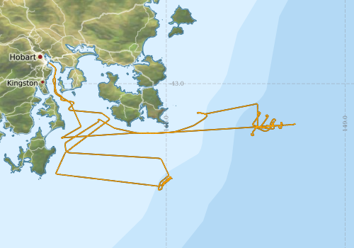
From: Hobart To: Hobart
Region: Derwent River, Tasmania coast, Southern Ocean
Ship: Investigator (RV) [details]
Description:
The primary voyage objective for these voyages, are for the Marine National Facility (MNF) to calibrate and commission new, upgraded and existing critical equipment (with sea trials and personnel training) onboard RV Investigator for upcoming voyages in the 2021 schedule and beyond. Specifically, work will focus on the seagoing testing and trials of MNF’s new Giant Piston Corer with 24m maximum barrel length capability, principally supported by the Geophysical Survey and Mapping team and marine geoscientists from UTAS.
Ancilliary Objectives (Piggybacks)
- A small contingent of scientists will advise on QAQC for collection of piston coring samples. The scientific advisors have supported voyage planning by advising appropriate sites of interest that target reduced risks to equipment and personnel, aid commissioning and gain scientific insight, notable thanks to Alix Post and Scott Nichol from Geoscience Australia. Due to traveling restrictions, Martin Jutzeler and Acacia Clark have agreed to fill in this QAQC role onboard the voyage. If cores are successful and of scientific value, they will be provided to the scientific advisors for analysis post voyage in accordance with CSIRO’s Data and Sample Management Policy.
- A 2nd Sea Surface Temperature Radiometer (ISAR) installed on port bridge wing for comparison to existing 1st ISAR unit. Requires running cable & conduit into bridge in port period (IN2021_P05_01) lead by Nicole Morgan from SIT.
- 2x participants from the Australian Antarctic Division (AAD) are seconded to our Geophysical Survey and Mapping team to undertake familiarisation training with RV Investigators’ acoustic calibrations and operations, given their similarity to new equipment onboard RSV Nuyina, arriving Oct 2021.
- Underway aerosol particulate CO2 sensor upgrade & replacement, testing & monitoring underway by Craig Neill from O&A.
Leader: Jason Fazey
Project: Investigator - general vessel operations, gear trials, etc. [details] Primary
Underway data from NRUD - see this voyage
Voyage extents: 43° 35.6' S to 42° 53.1' S 147° 20.7' E to 148° 43.2' E Get voyage track shapefile Get CSV
Marlin Metadata:-
Cruise Summary Report at SeaDataNet:-
Participants - on ship:-
| Name | Role | Organisation | Project |
|---|---|---|---|
| Jason Fazey | Chief Scientist | CSIRO National Collections and Marine Infrastructure | Investigator - general vessel operations, gear trials, etc. |
This list includes those that may have only been on part of the voyage. See voyage reports on 'Reports and Maps' tab for details.
Marine National Facility Reports - plans, summaries and data processing
-
IN2021_E01 Voyage Summary
- includes preliminary results, voyage narrative, types of data collected with C77/ROSCOP codes.
-
IN2021_E01 Voyage Plan
- includes objectives, investigator details, proposed data collection, voyage track and equipment to be used.
- View Survey map
Publications, reports and datasets from this voyage.
Dataset
- Fazey, Jason; Nau, Amy; Navidad, Cisco; Vandenbossche, Phil; Boyd, Matt; Taylor, Charlie; Plunkett, Tom (2022): IN2021_E01 Storm Bay Bathymetry 5m - 210m Multi-resolution AusSeabed products. v1. CSIRO. Data Collection. 10.25919/7v3v-z420
- Tilbrook, Bronte; Neill, Craig; Akl, John (2022). Integrated Marine Observing System (IMOS) sea surface and atmospheric fCO2 measurements in the Southern Ocean, South Pacific, Indian Ocean onboard R/V Investigator in 2021 (NCEI Accession 0253535). [indicate subset used]. NOAA National Centers for Environmental Information. Dataset. 10.25921/thsr-dd03
Search for publications, reports and datasets from this and other voyages
Data publishing
This is a list of online datasets hosted by CSIRO. Other processed datasets hosted by collaborating organisations may be found on the 'Metadata' or "Reports, Publications and Maps' tab.
Use the Get data link on the right to extract data using the NCMI Data Trawler.
| Data Stream | Data Summary | Get data | ||||||||||
|---|---|---|---|---|---|---|---|---|---|---|---|---|
| Multibeam echosounder |
|
Get Data from Trawler |
||||||||||
| pCO2 |
|
External link - download datafile at IMOS Data fields and units document (.pdf) |
||||||||||
| Sub-bottom profiler |
|
Get Data from Trawler |
||||||||||
| Singlebeam echosounder |
|
Get Data from Trawler |
||||||||||
| XBT Profile |
|
Get Data from Trawler |
| ID | When (UTC) | Lat | Long | Instrument | Identifier | Action | Log | Subject / Comment |
|---|
Deployments by start time:- Click on column header to sort. Use link on 'Deployment' to see full details. Use the CSV button at the bottom to export data (tab delimited).
Search for deployments from this voyage and others
| Deployment | Operation | Station | Cast | Gear | Project | Start and end times | Start Location | End Location | Depth range | Max Depth | Description | |||
|---|---|---|---|---|---|---|---|---|---|---|---|---|---|---|
| ADCP Data [details] | Teledyne RDI ADCP 150 kHz | 2549 | 2021-11-10 00:45 | 2021-11-13 22:43 | -42.9730 | 147.3794 | -43.1031 | 147.4813 | 718 | |||||
| XBT Cast [details] | 2391 | 2021-11-12 17:23 | 247.1 | |||||||||||