Voyage details and related metadata, reports, events and data.
IN2022_V05
- is a Marine National Facility ![]() voyage
voyage
Title: The tsunamigenic submarine landslides and deep-marine canyons of Australia’s Tasman Sea margin: Causes and Consequences
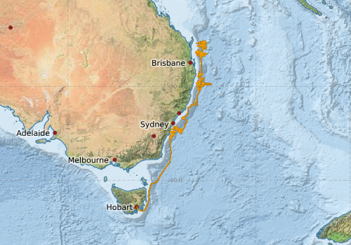
Period: 2022-05-28 00:00 to 2022-07-02 22:00 UTC
Duration: 35.92 days
From: Hobart To: Brisbane
Ship: Investigator (RV) [details]
Description:
This voyage will deploy the seismic reflection profiling system together with the multibeam sonar and sub- bottom profiling systems to map specific features of interest present on the continental slope and abyssal plain offshore the SEACM between Green Cape (Victoria – New South Wales Border) and the northern tip of Fraser Island (South-East Queensland). These mapping and profiling results will be used in conjunction with earlier survey results to inform the selection of appropriate core and dredge sites which will be sampled using the Jumbo Coring System, Box Dredges, and/or the Smith-MacIntrye Grab as is appropriate.
The primary objective of this voyage is to locate and sample deeper-water features that were beyond the operational ‘reach’ of the RV Southern Surveyor’s facilities and equipment. The earlier voyages investigating the marine geology of the region were not able to efficiently map or sample the lower slope, deep canyons, and abyssal plain features that represent the sites where upper-slope and mid-slope landslide materials are thought to be deposited. Included in this objective is the ‘maximised acquisition’ of abyssal plain bathymetry between the toe of the continental slope and the line of Tasman Seamounts located to the north of Port Macquarie.
The secondary objective is to identify, map, and sample continental-shelf-edge coastal features suspected to have delivered sediment to the upper-continental slope and canyon heads when sea-levels were lowered during the many Pliocene and Pleistocene glacial maxima. These features are thought to be a critical component of the “source-to-sink” sediment pathway that influences continental slope depositional and erosional processes.
Leader: Dr Hubble (USYD)
Projects:
Underway data from NRUD - see this voyage
Voyage extents: 43° 16.6' S to 25° 06.9' S 147° 19.9' E to 155° 13.2' E Get voyage track shapefile Get CSV
Marlin Metadata:-
Metadata from OBIS Australia datasets:- biological data is published via the OBIS-AU IPT server and delivered to one or more of OBIS, ALA and GBIF
Download from OBIS Australia IPT View at - Ocean Biodiversity Information System (OBIS) GBIF
Cruise Summary Report at SeaDataNet:-
Participants - on ship:-
| Name | Role | Organisation | Project |
|---|---|---|---|
| David Airey | Geotechnical Sampling | University of Sydney - Depart. of Geology & Geophysics | The tsunamigenic submarine landslides and deep-marine canyons of Australia’s Tasman Sea margin: Causes and Consequences |
| Hannah Power | Alternate Chief Scientist | University of Newcastle - Depart. of Geology | The tsunamigenic submarine landslides and deep-marine canyons of Australia’s Tasman Sea margin: Causes and Consequences |
| Mike Kinsela | Marine Geologist | University of Newcastle - Depart. of Geology | The tsunamigenic submarine landslides and deep-marine canyons of Australia’s Tasman Sea margin: Causes and Consequences |
| Tom Hubble | Chief Scientist | University of Sydney | The tsunamigenic submarine landslides and deep-marine canyons of Australia’s Tasman Sea margin: Causes and Consequences |
Participants - shore based:-
| Name | Role | Organisation | Project |
|---|---|---|---|
| Craig Hanstein | PI - piggyback | CSIRO Oceans & Atmosphere - Hobart | Argo float deployments |
This list includes those that may have only been on part of the voyage. See voyage reports on 'Reports and Maps' tab for details.
Marine National Facility Reports - plans, summaries and data processing
-
IN2022_V05 Voyage Plan
- includes objectives, investigator details, proposed data collection, voyage track and equipment to be used.
-
IN2022_V05 Underway Data Processing Report
- details of data processing steps, calibration information, instruments used and any issues with the data.
-
IN2022_V05 Voyage Summary
- includes preliminary results, voyage narrative, types of data collected with C77/ROSCOP codes.
-
IN2022_V05 Scientific Highlights
- report of the key outputs
-
IN2022_V05 ADCP Data Processing Report
- details of data processing steps, calibration information, instruments used and any issues with the data.
- View Survey map
Publications, reports and datasets from this voyage.
Conference Proceedings
- Buller, E. J., Power, H. E., Kinsela, M. A., Mollison, K. C., & Hubble, T. C. (2023). Assessing the tsunamigenic potential of a submarine landslide offshore brooms head, Australia. In Australasian Coasts & Ports 2023 Conference. Engineers Australia. https://search.informit.org/doi/10.3316/informit.474514525278763 External link to reference
Dataset
- Hubble, Tom; Davey, Craig; Kuna, Nelson; Navidad, Cisco (2023): IN2022_V05 Tasman Sea Margin Bathymetry 10m - 210m Multi-resolution AusSeabed products. v1. CSIRO. Data Collection. 10.25919/zkec-f612
IPT Resource
- Whale and dolphin observations during seismic survey of the east coast of Australia, RV Investigator voyage IN2022_V05 (2022) (Darwin Core Archive) External link to reference
Journal Article
- Lucieer, Vanessa,Flukes, Emma,Monk, Jacquomo,Walsh, Peter (2024) Geomorphometric maps of Australia’s Marine Park estate and their role in improving the integrated monitoring and management of marine ecosystems. Frontiers in Marine Science 10 pp-. 10.3389/fmars.2023.1302108
Search for publications, reports and datasets from this and other voyages
Data publishing
This is a list of online datasets hosted by CSIRO. Other processed datasets hosted by collaborating organisations may be found on the 'Metadata' or "Reports, Publications and Maps' tab.
Use the Get data link on the right to extract data using the NCMI Data Trawler.
| Data Stream | Data Summary | Get data | ||||||||||||
|---|---|---|---|---|---|---|---|---|---|---|---|---|---|---|
| ADCP Data |
|
Get Data from Trawler Download the 5 minute ADCP Data (NetCDF format) Download overview plots of collected OS150nb ADCP data Download the 5 minute ADCP Data (NetCDF format) Download overview plots of collected OS75nb ADCP data |
||||||||||||
| Marine biodiversity observations and/or samples |
|
Get Data from Trawler |
||||||||||||
| Gravity Measurements |
|
Get Data from Trawler |
||||||||||||
| Multibeam echosounder |
|
Get Data from Trawler |
||||||||||||
| pCO2 |
|
External link - download datafile at IMOS Data fields and units document (.pdf) |
||||||||||||
| Sub-bottom profiler |
|
Get Data from Trawler |
||||||||||||
| Singlebeam echosounder |
|
Get Data from Trawler |
||||||||||||
| SOOP Bio-acoustics |
|
External link - datafile at IMOS NetCDF Data Format: Manual Download |
||||||||||||
| Underway |
|
Get Data from Trawler Download the 5 minute Underway data (CSV format) Download the 1 minute Underway data (CSV format) Download the 5 second Underway data (netCDF format) Download the 5 second Underway data (CSV format) Download the 10-second Underway data (CSV format) Download the TSG Calibration Data (CSV format) |
||||||||||||
| XBT Profile |
|
Get Data from Trawler |
| ID | When (UTC) | Lat | Long | Instrument | Identifier | Action | Log | Subject / Comment |
|---|
Deployments by start time:- Click on column header to sort. Use link on 'Deployment' to see full details. Use the CSV button at the bottom to export data (tab delimited).
Search for deployments from this voyage and others
| Deployment | Operation | Station | Cast | Gear | Project | Start and end times | Start Location | End Location | Depth range | Max Depth | Description | |||
|---|---|---|---|---|---|---|---|---|---|---|---|---|---|---|
| Underway System [details] | Air Sampling Inlet Mode,Air Temperature Sensor - ROTRONIC T&RH HC2A-S3,Air Temperature Sensor - ROTRONIC T&RH HC2A-S3,Air Temperature Sensor - ROTRONIC T&RH HC2A-S3,Air Temperature Sensor - ROTRONIC T&RH HC2A-S3,Burket Flow meter,Burket Flow meter,CSIRO Hobart pCO2,CSIRO Hobart pCO2,CSIRO Hobart pCO2,CSIRO Hobart pCO2,CSIRO Hobart pCO2,CSIRO Hobart pCO2,CSIRO Hobart pCO2,CSIRO Hobart pCO2,CSIRO Hobart pCO2,CSIRO Hobart pCO2,CSIRO air sampling inlet,CSIRO air sampling inlet,Depth: TECHSAS-DERIVED. For more information contact the Data Acquisition and Processing group.,Fluorometer Concentration,Fluorometer WSCHL-1441,Gyrocompass,IMOS Port Pyranometer-SN 35123F3,IMOS Port Radiometer-SN 35111F3,IMOS Stbd Pyranometer-SN 35122F3,IMOS Stbd Radiometer-SN 35093F3,IMOS wind monitor,IMOS wind monitor,IMOS wind monitor,IMOS wind monitor,ISAR SST,Kobold MIK-C Flow meter,Kobold MIK-C Fluorometer Flow Meter,Kongsberg Maritime Skipper DL850 doppler log,Kongsberg Maritime Skipper DL850 doppler log,Kongsberg Maritime Skipper DL850 doppler log,Kongsberg Maritime Skipper DL850 doppler log,Kongsberg Maritime Skipper DL850 doppler log,Kongsberg Maritime Skipper DL850 doppler log,LI-COR LI-190 Quantum Sensor,LI-COR LI-190 Quantum Sensor,MAAP Status,Multiangle Absorption Photometer (MAAP),Multiangle Absorption Photometer (MAAP),Optode Dissolved Oxygen Concentration,Optode Dissolved Oxygen Saturation,Optode Water Temperature,Ozone Monitor RVT1,Ozone Monitor RVT1,Ozone Monitor RVT2,Ozone Monitor RVT2,Picarro Greenhouse Gas Spectrometer CO2,CH4,H2o,Picarro Greenhouse Gas Spectrometer CO2,CH4,H2o,Picarro Greenhouse Gas Spectrometer CO2,CH4,H2o,Port Rain Gauge,Port drop keel sensor,RM Young 05106 wind monitor,RM Young Wind Sensor Type 05106,RM Young Wind Sensor Type 05106,RM Young Wind Sensor Type 05106,RM Young Wind Sensor Type 05106,RM Young Wind Sensor Type 05106,RM Young Wind Sensor Type 05106,RM Young Wind Sensor Type 05106,RM Young Wind Sensor Type 05106,Remote Temperature (T) - SN 671,Seapath 330+,Seapath 330+,Seapath 330+,Seapath 330+,Starboard Rain Gauge,Starboard drop keel sensor,ThermoSalinoGraph (TSG)-SN 3465,ThermoSalinoGraph (TSG)-SN 3465,Vaisala Ship's Barometer PTB330 | 2022-05-27 23:13 | 2022-07-02 22:59 | -42.8445 | 147.3310 | -27.4285 | 153.1206 | |||||||
| ADCP Data [details] | Teledyne RDI ADCP 150 kHz | 2549 | 2022-05-28 05:32 | 2022-07-02 15:59 | -43.2733 | 147.7992 | -26.6646 | 153.2354 | 670 | |||||
| XBT Cast [details] | 2391 | 2022-05-29 04:42 | 1041 | |||||||||||
| XBT Cast [details] | 2391 | 2022-05-29 13:31 | 1017.1 | |||||||||||
| XBT Cast [details] | 2391 | 2022-05-29 23:24 | 1100.3 | |||||||||||
| XBT Cast [details] | 2391 | 2022-05-31 09:23 | 967.5 | |||||||||||
| XBT Cast [details] | 2391 | 2022-06-02 04:26 | 987.8 | |||||||||||
| XBT Cast [details] | 2391 | 2022-06-04 04:02 | 1025.5 | |||||||||||
| XBT Cast [details] | 2391 | 2022-06-05 09:16 | 1100.3 | |||||||||||
| XBT Cast [details] | 2391 | 2022-06-07 00:24 | 1100.3 | |||||||||||
| XBT Cast [details] | 2391 | 2022-06-08 09:37 | 1100.3 | |||||||||||
| XBT Cast [details] | 2391 | 2022-06-11 15:07 | 1100.3 | |||||||||||
| XBT Cast [details] | 2391 | 2022-06-12 17:41 | 1100.3 | |||||||||||
| XBT Cast [details] | 2391 | 2022-06-13 13:59 | 1100.3 | |||||||||||
| XBT Cast [details] | 2391 | 2022-06-14 15:30 | 1100.3 | |||||||||||
| XBT Cast [details] | 2391 | 2022-06-14 20:24 | 1100.3 | |||||||||||
| XBT Cast [details] | 2391 | 2022-06-16 16:11 | 997.4 | |||||||||||
| XBT Cast [details] | 2391 | 2022-06-18 17:11 | 1100.3 | |||||||||||
| XBT Cast [details] | 2391 | 2022-06-19 17:41 | 1100.3 | |||||||||||
| XBT Cast [details] | 2391 | 2022-06-21 07:02 | 1100.3 | |||||||||||
| XBT Cast [details] | 2391 | 2022-06-21 18:28 | 1100.3 | |||||||||||
| XBT Cast [details] | 2391 | 2022-06-22 18:17 | 1100.3 | |||||||||||
| XBT Cast [details] | 2391 | 2022-06-26 16:02 | 1100.3 | |||||||||||
| XBT Cast [details] | 2391 | 2022-06-27 18:05 | 1100.3 | |||||||||||
| XBT Cast [details] | 2391 | 2022-06-29 08:18 | 1100.3 | |||||||||||
| XBT Cast [details] | 2391 | 2022-06-30 16:02 | 1100.3 | |||||||||||