
Figures marked "CSIRO", are copyright CSIRO, but please feel free to use them, conditional on the figures not being altered, and their source being acknowledged, and with a link to this site where possible. All other figures are copyright. Please do not copy without the owner's permission.
|
Why does sea level change?Short term variabilitySome of the processes that drive short term (hours to days) changes in sea level are: TidesGravitational forces from the Moon and the Sun produce changes in sea level mostly on daily or half-daily time scales - tides. In many places the tidal signal is a mix of daily and half-daily tides. In the deep ocean the tidal range is typically a few tens of centimeters but in coastal regions it can be up to several metres. There are also longer term changes (particularly the modulation of the daily tide range of the Spring/Neap cycle), and smaller amplitude longer-period tides (including modulation of the tidal amplitude over the 18.6 year lunar cycle). Surface wavesWaves steepen and break as they encounter shallow coastal waters. The wave breaking leads to loss of energy and loss of wave height. Therefore, the further offshore these conditions are encountered the smaller the waves will be that finally reach the shore. Conversely, deeper waters lying adjacent to coastlines enable waves to travel closer into shore before finally breaking. These two situations are illustrated in Figure 1. Paradoxically, the conditions that ensure that waves lose energy before reaching the shore are the same conditions that favour larger storm surges. 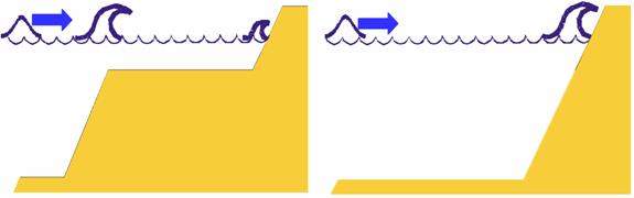 Figure 1: Shallow coastal waters (left) cause wave breaking and reduction of wave energy to occur further offshore while deeper coastal waters (right) allow higher energy waves to reach the shore. As the waves move progressively into shallower water, they break and lose energy. Some of this energy is transferred into a shoreward momentum flux which acts to raise the mean sea level slightly close into shore. This sea level increase is called wave setup. Typically wave setup values range from about 10 to 15% of deep water significant wave heights where the significant wave height is, by definition, the average height of the top one third of waves occurring at some deep water location (Guide to wave analysis and forecasting. World Meteorological Organisation, Report no. 702, 1988). Climate variability and change has a significant impact on wind and wave conditions globally. For example, studies in the North Atlantic Ocean have shown that wave heights have increased over the last few decades, displaying a strong relationship with the North Atlantic Oscillation, and inter-annual variability as great as 20 % (Woolf et al., 2002). Sterl and Caires (2005), in their analysis of the ERA-40 global waves re-analysis, identified significant trends in wave height, particularly in the Southern Ocean, the North Atlantic and the North Pacific. These trends are more pronounced in the high quantiles, indicating that the large wave events are increasing at a greater rate than the mean. In the Southern Ocean, Sterl and Caires (2005) identified an increased number of Southern Ocean storms as the reason for the observed trend in the model record. Interannual variability of wave direction in the Australian region has been recorded via beach rotation processes at a number of short embayed beaches along the East Australian coast (Ranasinghe et al. 2004). This rotation is linked to wave climate variability associated with the Southern Oscillation Index. During El-Nino phases, the beach rotates clockwise in response to changes in the wave climate, with the northern end of the beach accreting, and the southern end of the beach eroding. During the La-Nina phase, the opposite occurs with a net anti-clockwise rotation of the beach observed. Hemer et al. (2007) indicated a positive correlation between wave heights and the southern annular mode index along the southern and western margins of Australia, suggesting that a similar relationship may hold for these regions. Sea level rise will be felt most severely in response to storm driven wave and surge events, which lead to wave induced erosion of coastal landforms. Wave induced erosion is dependent on the water elevation relative to the height of the fronting beach face junction. The water level depends on the mean sea level, a tidal component, any storm surge component, and an increase in water level produced by waves, including the set-up and run-up of individual waves. Larger waves are therefore more easily able to erode the shoreline. In addition to the impacts of wave height, the rate at which beach material is redistributed along the shore is also dependent on the angle at which waves arrive in the coastal zone. Therefore, coastal morphology depends strongly on the wave climate the coast is exposed to. Changes to the wave climate, such as a shift in wave direction, or increase/decrease in wave heights, will therefore lead to erosion of the coast. Slott et al (2006) found shoreline change in response to changing wave climate due to changing storm patterns could be an order of magnitude greater than that caused by rising sea levels. The effects of wave erosionA commonly applied rule to explain erosion of sandy shores in response to sea level rise is the Bruun Rule (Bruun, 1962). It describes the cross-shore response of a beach to sea level rise. Bruun states that within the closure zone of the beach (typically the limit of significant wave-driven sediment transport), the beach will adjust to maintain its equilibrium profile relative to the still water level. This is achieved by translating the profile landwards and upwards, with eroded sediments at the landward end of the profile being deposited in the lower portion of the profile, and raising the bed, maintaining a net sediment balance. The landward translation is given by geometry, and is expressed as R = SL/(hd+f), Where S is the amount of sea level rise, L is the active length of the profile, hd is the closure depth, and f is the freeboard. R is typically of the order 50-100 times the magnitude of S.  Figure 2: Effect of wave action on a shore. The Bruun rule has several limitations. Firstly, the rule does not account for longshore interactions, and secondly, the rule assumes the wave climate is steady and hence the equilibrium profile remains the same - simply translated landwards and upwards with the rise in mean sea level. Such limitations should be considered when the Bruun rule is applied. Storm SurgesOnshore winds will pile up water onto a coastline, and offshore winds will do the opposite. Changes in atmospheric pressure also produce changes in sea level (lower atmospheric pressure leading to higher sea levels), so the effect of a severe storm (very low atmospheric pressure) with strong onshore winds can lead to very high coastal sea levels (Storm Surges) with, at times, severe coastal damage, especially when the large waves produced by the strong winds are added! Less extreme weather also produces less extreme changes in sea level. These storm surges can have devastating impacts - over 500,000 people were killed in the 1970 storm surge in Bangladesh. Since 1700 there have been 23 storm surges in Bangladesh that have (each) killed at least 10,000 people. The storm surge and surface waves generated by Hurricane Katrina had a devastating effect on New Orleans in August 2005, with over 1000 people killed and over $US100Billion in damages. Storm surges are long period waves with a wavelength of several tens of kilometres that are generated by the winds and falling pressure associated with severe weather events. There are two ways in which the wind can act to elevate coastal sea levels. The first, called 'wind setup' (Figure 3a), is effectively the pushing of the water against the coast, leading to cyclone as it approaches the coast. Wind setup can also occur within semi-enclosed bays when the wind has been blowing steadily from a particular direction over a number of hours. The second way in which winds can generate elevated sea levels at the coast is via 'current setup' (Figure 3b). When the wind blows in a largely coast parallel direction, it induces coast parallel flow. If these currents are sustained over periods of a day or more, the rotation of the earth (the Coriolis effect) causes the currents to become deflected to the left (right) of the direction of flow in the southern (northern) hemisphere. If a coastal barrier blocks the deflected flow, elevated coastal sea levels will result. This process however, is more important in the mid-latitudes where the Coriolis effect is stronger and storm depressions are of larger size, are generally less intense and are of longer duration than tropical cyclones. 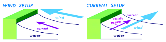 Figure 3: The main dynamic processes leading to increased sea levels at the coast due to the wind. The falling atmospheric pressure at the centre of a tropical cyclone can also increase sea levels by acting like a suction on the ocean surface. This process is known as the inverted or inverse barometer effect. The rate of sea level rise is approximately 1 cm per hPa fall in pressure. Coastal geometry also influences the severity of storm surges experienced at the coast. Storm surges are amplified by wide continental shelves. This is because the currents caused by the wind are slowed down by the friction created by the ocean floor over the shallower shelf region and this in turn causes the water depth to increase. Other topographic features such as headlands can also either amplify or protect a coastal region from storm surge depending on the prevailing wind direction in relation to the headland. The storm conditions that create storm surges will also create large wind-generated waves. In some situations and locations, such as coastlines and islands with little or no continental shelf, waves may produce a greater impact than the storm surge in a severe storm. Unlike storm surges which are generated by storm systems in the immediate vicinity, the sources of waves include not only local weather conditions but also distant storms. This is because waves can travel long distances in deep water from their point of origin with little loss of energy. Such waves are called swell. Extreme sea levels - causesExtreme sea levels can be caused by high tides, particularly spring high tides, storm surges and wave breaking processes at the coast. The interaction of these various processes is illustrated in Figure 4. 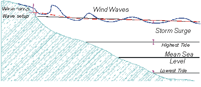 Figure 4: Contributions to coastal sea level from tides, storm surge and wave processes. Other factorsSome earthquakes cause a very rapid vertical movement of the ocean floor and in these cases generate tsunamis (tidal waves), such as the 2004 Boxing Day Tsunami in the Indian Ocean. Tsunamis travel at speeds of about 200 metres per second in the deep ocean (about 700 kilometres per hour), taking several hours to cross an ocean basin allowing time for tsunamis warnings to be issued. Tsunami warning systems are being strengthened since the 2004 Boxing Day Tsunami. ReferencesBruun, P. (1962), sea level rise as a cause of shore erosion. Journal Waterways and Harbours Division, 88(1-3), 117-130. Hemer, M.A., J.A. Church and J.R. Hunter (2007), Waves and climate change on the Australian coast. Journal of Coastal Research. SI, 50, 432-437. Ranasinghe, R., R. McLoughlin, A. Short and G. Symonds (2004), The Southern Oscillation Index, wave climate, and beach rotation. Marine Geology, 204, 273-287. Slott, J.M., A.B. Murray, A.D. Ashton and T.J. Crowley (2006), Coastline responses to changing storm patterns. Geophysical Research Letters, 33, L19404, doi:10.1029/2006GL027445. Sterl, A. and S. Caires (2005), Climatology, Variability and Extrema of Ocean Waves - The Web-based KNMI/ERA-40 Wave Atlas. Int. J. Climatology, 25(7), 963-997, doi:10.1029/joc.1175. Woolf. D.K., P.G. Challenor and P.D. Cotton (2002), Variability and predictibility of the North Atlantic wave climate. Journal of Geophysical Research, 107 (C10), 3145, soi:10.1029/2001JC001124. |
|
Website owner: Benoit Legresy | Last modified 22/04/08
|
![]()
