Survey details and related metadata, reports, events and data.
SO 2/84 (alternative identifier: SO198402)
Period: 1984-04-16 00:00 to 1984-05-13 00:00 Local
Duration: 27.00 days
Region: E Tasmania
Ship: Soela [details]
Description: Soela cruise SO 2/84 was undertaken to conduct a demersal fish survey in waters off Maria Island, east Tasmania and the waters around Tasmania and in the east Bass Strait. Leg 1 cruise aims were to establish the site of the core study area for detailed investigation of the fish communites over the continental slope (450-650m). To conduct demersal fish and larval fish sampling, pelagic trawling and mesopelagic fish sampling in the core area. Also to conduct biological oceanography and routine hydrology stations (XBTs and Nansen casts), and at larval stations. Leg 2 cruise aims were to conduct sampling of larval fish from around Tasmania, demersal fish in the eastern Bass Strait and blue grenadier from the west coast of Tasmania. Also to conduct biological oceanography and routine hydrology (XBTs and Nansen casts) in the demersal sampling areas, and larval fish transects.
Leader: S. Blaber & F.B. Griffiths (CSIRO)
Project: "Soela" fish surveys, 1980s [details]
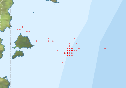
Voyage extents: 42° 43.0' S to 42° 31.0' S 148° 05.0' E to 148° 29.0' E
Marlin Metadata:-
Metadata from OBIS Australia datasets:- biological data is published via the OBIS-AU IPT server and delivered to one or more of OBIS, ALA and GBIF
Download from OBIS Australia IPT View at - Ocean Biodiversity Information System (OBIS) Atlas of Living Australia (ALA) GBIF
Participants:- no records
Marine National Facility Reports - plans, summaries and data processing
- View the Survey plan - includes objectives, investigator details, proposed data collection, voyage track and equipment to be used.
- View the Survey Summary report - includes preliminary results, voyage narrative, types of data collected with C77/ROSCOP codes.
- There is no map for this survey.
Search for publications, reports and datasets from this and other voyages
Data publishing
This is a list of online datasets hosted by CSIRO. Other processed datasets hosted by collaborating organisations may be found on the 'Metadata' or "Reports, Publications and Maps' tab.
Use the Get data link on the right to extract data using the NCMI Data Trawler.
| Data Stream | Data Summary | Get data | ||||||||||
|---|---|---|---|---|---|---|---|---|---|---|---|---|
| Marine biodiversity observations and/or samples |
|
Get Data from Trawler |
||||||||||
| Catch Details (deprecated - now bio) |
|
Get Data from Trawler |
||||||||||
| Hydrology |
|
Get Data from Trawler |
Deployments by start time:- Click on column header to sort. Use link on 'Deployment' to see full details. Use the CSV button at the bottom to export data (tab delimited).
Search for deployments from this voyage and others
| Deployment | Operation | Station | Cast | Gear | Project | Start and end times | Start Location | End Location | Depth range | Max Depth | Description | |||
|---|---|---|---|---|---|---|---|---|---|---|---|---|---|---|
| Hydrology Cast [details] | 1 | 35 | 1984-04-16 00:00 | 1984-04-16 00:00 | -42.6333 | 148.4167 | 400 | |||||||
| Hydrology Cast [details] | 1 | 35 | 1984-04-16 00:00 | 1984-04-16 00:00 | -42.6667 | 148.4167 | 473 | |||||||
| Hydrology Cast [details] | 1 | 35 | 1984-04-16 00:00 | 1984-04-16 00:00 | -42.7167 | 148.4000 | 345 | |||||||
| Catch [details] | 1 | Engel demersal high lift | 35 | 1984-04-16 16:40 | 1984-04-16 17:33 | -42.6500 | 148.4167 | -42.6333 | 148.4167 | Trawling | ||||
| Catch [details] | 2 | Engel demersal high lift | 35 | 1984-04-16 20:30 | 1984-04-16 21:20 | -42.6833 | 148.4167 | -42.6500 | 148.4167 | Trawling | ||||
| Catch [details] | 3 | Engel demersal high lift | 35 | 1984-04-17 00:15 | 1984-04-17 01:05 | -42.6833 | 148.4000 | -42.6500 | 148.4167 | Trawling | ||||
| Catch [details] | 4 | Engel demersal high lift | 35 | 1984-04-17 05:50 | 1984-04-17 06:40 | -42.6833 | 148.4167 | -42.6500 | 148.4167 | Trawling | ||||
| Catch [details] | 5 | Engel demersal high lift | 35 | 1984-04-17 10:15 | 1984-04-17 11:05 | -42.6667 | 148.4167 | -42.6500 | 148.4167 | Trawling | ||||
| Catch [details] | 6 | Engel demersal high lift | 35 | 1984-04-17 16:05 | 1984-04-17 16:47 | -42.6667 | 148.4333 | Trawling | ||||||
| Catch [details] | 7 | Engel demersal high lift | 35 | 1984-04-17 20:35 | 1984-04-17 21:25 | -42.6833 | 148.4167 | -42.6500 | 148.4333 | Trawling | ||||
| Hydrology Cast [details] | 1 | 35 | 1984-04-18 00:00 | 1984-04-18 00:00 | -42.6667 | 148.4167 | 400 | |||||||
| Hydrology Cast [details] | 1 | 35 | 1984-04-18 00:00 | 1984-04-18 00:00 | -42.6833 | 148.4167 | 400 | |||||||
| Catch [details] | 8 | Engel midwater | 35 | 1984-04-18 04:52 | -42.6833 | 148.4500 | -42.7000 | 148.4500 | 100 | |||||
| Catch [details] | 9 | Rectangular Midwater Trawl 8 | 35 | 1984-04-18 09:29 | 1984-04-18 10:22 | -42.7000 | 148.4000 | -42.6667 | 148.4167 | 200 | Trawling | |||
| Catch [details] | 10 | Rectangular Midwater Trawl 8 | 35 | 1984-04-18 13:56 | 1984-04-18 14:46 | -42.7167 | 148.4000 | -42.6833 | 148.4000 | 400 | Trawling | |||
| Catch [details] | 11 | Rectangular Midwater Trawl 8 | 35 | 1984-04-18 16:10 | 1984-04-18 17:00 | -42.7000 | 148.4000 | 50 | Trawling | |||||
| Catch [details] | 12 | Rectangular Midwater Trawl 8 | 35 | 1984-04-18 21:44 | -42.6833 | 148.4167 | -42.6667 | 148.4333 | 200 | Trawling | ||||
| Hydrology Cast [details] | 1 | 35 | 1984-04-19 00:00 | 1984-04-19 00:00 | -42.6833 | 148.4333 | 400 | |||||||
| Catch [details] | 14 | Rectangular Midwater Trawl 8 | 35 | 1984-04-19 04:42 | 1984-04-19 05:54 | -42.6833 | 148.4167 | -42.6500 | 148.4333 | 50 | Trawling | |||
| Catch [details] | 15 | Rectangular Midwater Trawl 8 | 35 | 1984-04-19 06:09 | 1984-04-19 07:49 | -42.6667 | 148.4333 | -42.6167 | 148.4667 | 400 | Trawling | |||
| Catch [details] | 16 | Rectangular Midwater Trawl 8 | 35 | 1984-04-19 09:19 | 1984-04-19 10:09 | -42.7167 | 148.4167 | -42.6833 | 148.4167 | Trawling | ||||
| Catch [details] | 17 | Rectangular Midwater Trawl 8 | 35 | 1984-04-19 10:30 | 1984-04-19 11:20 | -42.7167 | 148.4167 | -42.7000 | 148.4333 | Trawling | ||||
| Catch [details] | 18 | Rectangular Midwater Trawl 8 | 35 | 1984-04-19 11:35 | -42.7167 | 148.4000 | -42.6667 | 148.4333 | Trawling | |||||
| Catch [details] | 19 | Rectangular Midwater Trawl 8 | 35 | 1984-04-19 13:35 | 1984-04-19 14:25 | -42.6833 | 148.4333 | -42.6667 | 148.4333 | Trawling | ||||
| Catch [details] | 20 | Rectangular Midwater Trawl 8 | 35 | 1984-04-19 15:55 | 1984-04-19 17:10 | -42.6833 | 148.4167 | -42.6500 | 148.4167 | 200 | Trawling | |||
| Catch [details] | 21 | Rectangular Midwater Trawl 8 | 35 | 1984-04-19 17:41 | 1984-04-19 18:56 | -42.7167 | 148.4000 | -42.6667 | 148.4333 | Trawling | ||||
| Hydrology Cast [details] | 1 | 35 | 1984-04-20 00:00 | 1984-04-20 00:00 | -42.5167 | 148.0833 | 30 | |||||||
| Hydrology Cast [details] | 1 | 35 | 1984-04-20 00:00 | 1984-04-20 00:00 | -42.5500 | 148.1333 | 50 | |||||||
| Hydrology Cast [details] | 1 | 35 | 1984-04-20 00:00 | 1984-04-20 00:00 | -42.6167 | 148.2667 | 90 | |||||||
| Catch [details] | 22 | Rectangular Midwater Trawl 8 | 35 | 1984-04-20 01:20 | -42.6833 | 148.3333 | -42.6333 | 148.2833 | Trawling | |||||
| Catch [details] | 23 | Rectangular Midwater Trawl 8 | 35 | 1984-04-20 02:48 | 1984-04-20 03:38 | -42.6167 | 148.3000 | -42.6333 | 148.2833 | Trawling | ||||
| Catch [details] | 24 | Rectangular Midwater Trawl 8 | 35 | 1984-04-20 05:03 | 1984-04-20 05:53 | -42.5333 | 148.0500 | -42.5167 | 148.0833 | 40 | Trawling | |||
| Catch [details] | 25 | Rectangular Midwater Trawl 8 | 35 | 1984-04-20 05:50 | -42.5167 | 148.0833 | 40 | Trawling | ||||||
| Catch [details] | 26 | Rectangular Midwater Trawl 8 | 35 | 1984-04-20 06:15 | -42.5333 | 148.0667 | -42.5167 | 148.0833 | 42 | Trawling | ||||
| Catch [details] | 27 | Rectangular Midwater Trawl 8 | 35 | 1984-04-20 08:03 | 1984-04-20 08:53 | -42.5500 | 148.1167 | -42.6000 | 148.1500 | 10 | Trawling | |||
| Catch [details] | 28 | Rectangular Midwater Trawl 8 | 35 | 1984-04-20 11:19 | 1984-04-20 11:57 | -42.6167 | 148.1833 | -42.6000 | 148.1667 | 70 | Trawling | |||
| Catch [details] | 29 | Rectangular Midwater Trawl 8 | 35 | 1984-04-20 13:59 | 1984-04-20 14:51 | -42.6000 | 148.2667 | -42.6167 | 148.2833 | 102 | Trawling | |||
| Hydrology Cast [details] | 1 | 35 | 1984-04-21 00:00 | 1984-04-21 00:00 | -42.6667 | 148.4833 | 1000 | |||||||
| Catch [details] | 30 | Engel midwater 152 | 35 | 1984-04-21 22:40 | 1984-04-21 23:47 | -42.6667 | 148.4000 | Trawling | ||||||
| Catch [details] | 31 | Engel midwater 152 | 35 | 1984-04-22 00:55 | 1984-04-22 02:07 | -42.7000 | 148.4167 | -42.6500 | 148.4333 | 350 | Trawling | |||
| Catch [details] | 32 | Engel midwater 152 | 35 | 1984-04-22 06:00 | 1984-04-22 07:07 | -42.6833 | 148.4333 | -42.7000 | 148.4333 | 280 | Trawling | |||
| Catch [details] | 33 | Engel midwater 152 | 35 | 1984-04-22 09:30 | 1984-04-22 10:42 | -42.6833 | 148.4167 | -42.6500 | 148.4167 | 450 | Trawling | |||
| Catch [details] | 34 | Engel midwater 152 | 35 | 1984-04-22 11:40 | 1984-04-22 12:30 | -42.7000 | 148.3833 | -42.6833 | 148.4167 | 40 | Trawling | |||
| Catch [details] | 35 | Engel midwater 152 | 35 | 1984-04-24 11:45 | 1984-04-24 12:27 | -42.6833 | 148.4167 | -42.6333 | 148.4167 | 200 | Trawling | |||
| Catch [details] | 36 | Engel midwater 152 | 35 | 1984-04-24 19:25 | 1984-04-24 20:07 | -42.7000 | 148.3833 | -42.6500 | 148.4333 | 350 | Trawling | |||
| Catch [details] | 37 | Engel midwater 152 | 35 | 1984-04-24 22:45 | 1984-04-25 00:02 | -42.7000 | 148.4000 | -42.6500 | 148.4167 | 420 | Trawling | |||
| Catch [details] | 38 | Engel midwater 152 | 35 | 1984-04-25 01:25 | 1984-04-25 02:15 | -42.7167 | 148.4167 | -42.6833 | 148.4000 | 25 | Trawling | |||
| Catch [details] | 39 | Engel midwater 152 | 35 | 1984-04-25 03:51 | 1984-04-25 04:39 | -42.7000 | 148.3833 | -42.6833 | 148.4000 | 205 | Trawling | |||
| Catch [details] | 40 | Engel midwater 152 | 35 | 1984-04-25 06:08 | 1984-04-25 06:56 | -42.7667 | 148.3667 | -42.7333 | 148.3667 | 230 | Trawling | |||
| Catch [details] | 41 | Engel midwater 152 | 35 | 1984-04-25 09:05 | 1984-04-25 09:55 | -42.6833 | 148.4000 | -42.6500 | 148.4167 | 350 | Trawling | |||
| Catch [details] | 42 | Engel midwater 152 | 35 | 1984-04-25 12:05 | 1984-04-25 12:55 | -42.7000 | 148.4333 | -42.6833 | 148.4333 | 280 | Trawling | |||
| Catch [details] | 43 | Engel midwater 152 | 35 | 1984-04-25 14:52 | 1984-04-25 15:45 | -42.7000 | 148.4000 | -42.6667 | 148.4333 | 200 | Trawling | |||
| Catch [details] | 44 | Engel midwater 152 | 35 | 1984-04-25 17:05 | 1984-04-25 18:13 | -42.7000 | 148.3833 | -42.6667 | 148.4000 | 120 | Trawling | |||
| Catch [details] | 45 | IYGPT (Midwater International) | 35 | 1984-04-25 23:20 | 1984-04-26 00:10 | -42.7000 | 148.4000 | 325 | Trawling | |||||
| Hydrology Cast [details] | 1 | 35 | 1984-04-26 00:00 | 1984-04-26 00:00 | -42.6833 | 148.4667 | 1047 | |||||||
| Catch [details] | 46 | IYGPT (Midwater International) | 35 | 1984-04-26 01:00 | 1984-04-26 01:25 | -42.6833 | 148.4333 | 460 | Trawling | |||||
| Catch [details] | 47 | IYGPT (Midwater International) | 35 | 1984-04-26 03:05 | 1984-04-26 03:55 | -42.6833 | 148.4333 | 250 | Trawling | |||||
| Catch [details] | 48 | IYGPT (Midwater International) | 35 | 1984-04-26 05:30 | 1984-04-26 06:20 | -42.7167 | 148.4333 | -42.7000 | 148.4333 | Trawling | ||||
| Catch [details] | 49 | IYGPT (Midwater International) | 35 | 1984-04-26 08:09 | 1984-04-26 08:59 | -42.7000 | 148.4000 | -42.6833 | 148.4000 | 145 | Trawling | |||
| Catch [details] | 50 | IYGPT (Midwater International) | 35 | 1984-04-26 10:35 | 1984-04-26 11:25 | -42.6667 | 148.4000 | 410 | Trawling | |||||
| Catch [details] | 51 | IYGPT (Midwater International) | 35 | 1984-04-26 12:32 | 1984-04-26 13:30 | -42.6833 | 148.4333 | -42.6667 | 148.4333 | 34 | Trawling | |||
| Catch [details] | 52 | IYGPT (Midwater International) | 35 | 1984-04-27 14:30 | 1984-04-27 15:20 | -42.6833 | 148.4000 | -42.6667 | 148.4833 | 300 | Trawling | |||
| Catch [details] | 53 | Engel midwater 152 | 35 | 1984-04-27 22:00 | 1984-04-28 01:37 | -42.6667 | 148.6667 | -42.7000 | 148.8500 | 850 | Trawling | |||
| Catch [details] | 54 | Rectangular Midwater Trawl 8 | 35 | 1984-04-28 01:30 | 1984-04-28 04:00 | -42.6333 | 148.4667 | -42.6000 | 148.4167 | Trawling | ||||
| Catch [details] | 55 | Rectangular Midwater Trawl 8 | 35 | 1984-04-28 03:56 | 1984-04-28 06:11 | -42.6000 | 148.4500 | -42.6500 | 148.4833 | Trawling | ||||
| Catch [details] | 56 | Rectangular Midwater Trawl 8 | 35 | 1984-04-28 07:00 | 1984-04-28 07:50 | -42.7000 | 148.4333 | -42.6667 | 148.4333 | 520 | Trawling | |||