Voyage details and related metadata, reports, events and data.
IN2017_C02
- is a Marine National Facility ![]() voyage
voyage
Title: RAN Hydrographic Survey
Voyage details on MNF site: https://mnf.csiro.au/en/Voyages/IN2017_C02
Period: 2017-05-03 22:00 to 2017-05-14 22:00 UTC
Duration: 11.00 days
From: Hobart To: Bell Bay
Region: Tasmanian eastern coast, Bass Strait, Victoria southern coast.
Ship: Investigator (RV) [details]
Description: RV Investigator research voyage in2017_c02, titled "RAN Hydrographic Survey." Voyage objectives: to undertake hydrographic survey operations in the vicinity of Hogan Island (Bass Strait) to facilitate safe navigation for international and coastal shipping. The meteorological and oceanographic observations and data collection have three purposes, namely: a. To collect data from which a sonar or radar range prediction can be calculated (humidity, pressure, temperature, wind speed, ocean temperature and salinity profile, currents through depth, sediment type, sub-bottom classification, where possible). b. To identify what observations can be conducted concurrently, and what observations have limiting factors that preclude concurrent operations/survey activity. c. To develop understanding of what types, accuracy and formats of data can be collected and how this might be of use to the scientific community and Defence.
Leader: LCDR Richard Cullen
Project: Hogan group, Bass Strait hydrographic survey [details] Primary
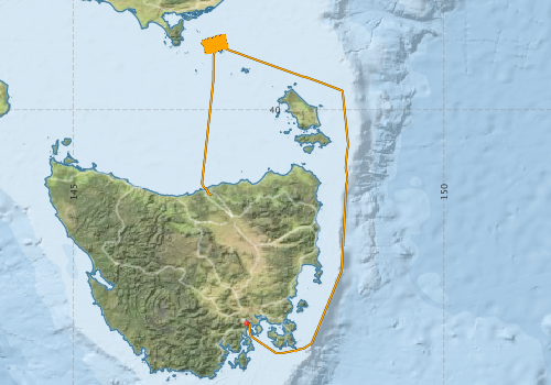
Voyage extents: 43° 17.5' S to 38° 59.4' S 146° 43.2' E to 148° 42.5' E Get voyage track shapefile Get CSV
Marlin Metadata:-
Cruise Summary Report at SeaDataNet:-
Participants - on ship:-
| Name | Role | Organisation | Project |
|---|---|---|---|
| Matt Boyd | Voyage Manager | Marine National Facility | Voyage Management on RV Investigator |
| Richard Cullen | Chief Scientist | Royal Australian Navy | Hogan group, Bass Strait hydrographic survey |
This list includes those that may have only been on part of the voyage. See voyage reports on 'Reports and Maps' tab for details.
Marine National Facility Reports - plans, summaries and data processing
-
IN2017_C02 Scientific Highlights
- report of the key outputs
-
IN2017_C02 Voyage Plan
- includes objectives, investigator details, proposed data collection, voyage track and equipment to be used.
-
IN2017_C02 ADCP Processing Report
- details of data processing steps, calibration information, instruments used and any issues with the data.
-
IN2017_C02 Underway Data Processing Report
- details of data processing steps, calibration information, instruments used and any issues with the data.
-
IN2017_C02 Voyage Summary
- includes preliminary results, voyage narrative, types of data collected with C77/ROSCOP codes.
- View Survey map
Publications, reports and datasets from this voyage.
Dataset
- Bakker, Dorothee C E; Lauvset, Siv K; Wanninkhof, Rik; Castaño-Primo, Rocío; Currie, Kim I; Jones, Steve D; Landa, Camilla S; Metzl, Nicolas; Nakaoka, Shin-Ichiro; Nojiri, Yukihiro; Nonaka, Isao; O'Brien, Kevin M; Olsen, Are; Pfeil, Benjamin; Pierrot, Denis; Schuster, Ute; Smith, Karl; Sullivan, Kevin; Sutton, Adrienne; Tilbrook, Bronte; Alin, Simone; Becker, Meike; Benoit-Cattin, Alice; Bott, Randy; Bozec, Yann; Bozzano, Roberto; Burger, Eugene; Burgers, Tonya; Cai, Wei-Jun; Chen, Liqi; Chierici, Melissa; Corredor, Jorge; Cosca, Catherine E; Cross, Jessica; Dandonneau, Yves; De Carlo, Eric Heinen; Dietrich, Colin; Else, Brent G T; Emerson, Steven R; Farías, Laura; Fransson, Agneta; Garreaud, René D; Gkritzalis, Thanos; Glockzin, Michael; González-Dávila, Melchor; Gregor, Luke; Hartman, Sue E; Hermes, Rudolf; Hoppema, Mario; Howden, Stephan; Hunt, Christopher W; Hydes, David; Ibánhez, J Severino P; Kitidis, Vassilis; Körtzinger, Arne; Kozyr, Alexander; Kuwata, Akira; Lampitt, Richard Stephen; Lefèvre, Nathalie; Lo Monaco, Claire; Maenner, Stacy M; Manke, Ansley; Manzello, Derek P; McGillis, Wade; Mickett, John; Monteiro, Pedro M S; Morell, Julio; Morrison, Ru; Mucci, Alfonso; Munro, David R; Musielewicz, Sylvia; Negri, Ruben M; Newberger, Timothy; Newton, Jan; Noakes, Scott; O'Brien, Chris; Ólafsdóttir, Sólveig Rósa; Ólafsson, Jón; Ono, Tsuneo; Osborne, John; Ouyang, Zhangxian; Padín, Xose Antonio; Papakyriakou, Tim N; Plüddemann, Albert J; Rehder, Gregor; Sabine, Christopher L; Sakurai, Keizo; Salisbury, Joe; Santana-Casiano, Juana Magdalena; Schlitzer, Reiner; Schneider, Bernd; Send, Uwe; Skjelvan, Ingunn; Steinhoff, Tobias; Sulpis, Olivier; Sutherland, Stewart C; Sweeney, Colm; Tadokoro, Kazuaki; Takahashi, Taro; Telszewski, Maciej; Thomas, Helmuth; Tomlinson, Michael; Trull, Tom W; Valdimarsson, Héðinn; van Heuven, Steven; Vandemark, Doug; Wada, Chisato; Wallace, Douglas WR; Watson, Andrew J; Weller, Robert A; Xu, Suqing (2018): Surface Ocean CO2 Atlas (SOCAT) V6. PANGAEA 10.1594/PANGAEA.890974
- Tilbrook, Bronte; Neill, Craig; Akl, John (2017). Integrated Marine Observing System (IMOS) sea surface and atmospheric fCO2 measurements in the Southern Ocean onboard R/V Investigator in 2017 (NCEI Accession 0169488). [indicate subset used]. NOAA National Centers for Environmental Information. Dataset. 10.7289/v5rv0kz4
Journal Article
- Paxton, Hannelore,Budaeva, Nataliya,Gunton, Laetitia M. (2023) Amazing diversity of Nothria (Annelida, Onuphidae) in the Australian deep sea. Records of the Australian Museum 75 pp215-247. 10.3853/j.2201-4349.75.2023.1802
- Watling, Les,Lapointe, Abby (2022) Global biogeography of the lower bathyal (700–3000 m) as determined from the distributions of cnidarian anthozoans. Deep Sea Research Part I: Oceanographic Research Papers 181 pp103703-. 10.1016/j.dsr.2022.103703
- Zhang, Haifeng,Beggs, Helen,Griffin, Christopher,Govekar, Pallavi Devidas (2023) Validation of Himawari-8 Sea Surface Temperature Retrievals Using Infrared SST Autonomous Radiometer Measurements. Remote Sensing 15 pp2841-. 10.3390/rs15112841
Search for publications, reports and datasets from this and other voyages
Data publishing
This is a list of online datasets hosted by CSIRO. Other processed datasets hosted by collaborating organisations may be found on the 'Metadata' or "Reports, Publications and Maps' tab.
Use the Get data link on the right to extract data using the NCMI Data Trawler.
| Data Stream | Data Summary | Get data | ||||||||||||||
|---|---|---|---|---|---|---|---|---|---|---|---|---|---|---|---|---|
| ADCP Data |
|
Get Data from Trawler Overview of the ADCP OS75 Dataset (Zipped HTML) Download the ADCP Data (NetCDF, 5 minute): in2017_c02_os75nb.nc |
||||||||||||||
| Gravity Measurements |
|
Get Data from Trawler Geophysical Survey and Mapping acquisition report |
||||||||||||||
| pCO2 |
|
External link - download datafile at IMOS Data fields and units document (.pdf) |
||||||||||||||
| Radon measurements |
|
Get Data from Trawler Download RV Investigator Radon dataset (XLSX) |
||||||||||||||
| Sub-bottom profiler |
|
Get Data from Trawler |
||||||||||||||
| Singlebeam echosounder |
|
Get Data from Trawler |
||||||||||||||
| Sea Surface Temperature |
|
Get Data from Trawler Download IN2017_C02 compressed dataset (2 Mb) |
||||||||||||||
| Underway |
|
Get Data from Trawler Download the 10-second csv data: in2017_c02uwy10sec_csv.zip (6.8MB) Download the 5 minute csv data: in2017_c02uwy5min_csv.zip (274KB) Download the 5 second Underway data: in2017_c02uwy_nc.zip (36.3 MB) |
| ID | When (UTC) | Lat | Long | Instrument | Identifier | Action | Log | Subject / Comment |
|---|
Deployments by start time:- Click on column header to sort. Use link on 'Deployment' to see full details. Use the CSV button at the bottom to export data (tab delimited).
Search for deployments from this voyage and others
| Deployment | Operation | Station | Cast | Gear | Project | Start and end times | Start Location | End Location | Depth range | Max Depth | Description | |||
|---|---|---|---|---|---|---|---|---|---|---|---|---|---|---|
| Underway System [details] | Altimeter-163,Autosal Salinometer,Burket Flow meter,Burket Flow meter,CSIRO Hobart pCO2,CSIRO Hobart pCO2,CSIRO Hobart pCO2,CSIRO Hobart pCO2,CSIRO Hobart pCO2,CSIRO Hobart pCO2,CSIRO Hobart pCO2,CSIRO Hobart pCO2,CSIRO Hobart pCO2,CSIRO Hobart pCO2,CSIRO air sampling inlet,CSIRO air sampling inlet,Chelsea Tech Fluorometer,Gyrocompass,Humidity Sensor-HMT333,Humidity Sensor-HMT333,Humidity Sensor-HMT333,Humidity Sensor-HMT333,IMOS Port Pyranometer-SN 29125F3,IMOS Port Radiometer-SN 29140F3,IMOS Stbd Pyranometer-SN 29125F3,IMOS Stbd Radiometer-SN 29140F3,IMOS wind monitor,IMOS wind monitor,IMOS wind monitor,IMOS wind monitor,ISAR SST,Kobold MIK-C Flow meter,Kongsberg Maritime Skipper DL850 doppler log,Kongsberg Maritime Skipper DL850 doppler log,Kongsberg Maritime Skipper DL850 doppler log,Kongsberg Maritime Skipper DL850 doppler log,Kongsberg Maritime Skipper DL850 doppler log,Kongsberg Maritime Skipper DL850 doppler log,LI-COR LI-190 Quantum Sensor,LI-COR LI-190 Quantum Sensor,Multiangle Absorption Photometer (MAAP),Multiangle Absorption Photometer (MAAP),Ozone Monitor RVT1,Ozone Monitor RVT1,Ozone Monitor RVT2,Ozone Monitor RVT2,Picarro Greenhouse Gas Spectrometer CO2,CH4,H2o,Picarro Greenhouse Gas Spectrometer CO2,CH4,H2o,Picarro Greenhouse Gas Spectrometer CO2,CH4,H2o,Port drop keel sensor,RM Young 05106 wind monitor-SN 82705,RM Young Rain Gauge,RM Young Wind Sensor Type 05107,RM Young Wind Sensor Type 05107,RM Young Wind Sensor Type 05107,RM Young Wind Sensor Type 05107,RM Young Wind Sensor Type 05108,RM Young Wind Sensor Type 05108,RM Young Wind Sensor Type 05108,RM Young Wind Sensor Type 05108,Remote Temperature (T) - SN 671,Seapath 330+,Seapath 330+,Seapath 330+,Simrad EK60 multi-frequency split-beam echosounder,Starboard drop keel sensor,ThermoSalinoGraph (TSG)-SS-SN 1777,Vaisala Ship's Barometer PTB330 | 2455 | 2017-05-03 22:02 | 2017-05-14 22:03 | -42.8864 | 147.3388 | -41.1387 | 146.8597 | ||||||
| ADCP Data [details] | Teledyne RDI ADCP 75 kHz | 2455 | 2017-05-04 17:03 | 2017-05-15 08:08 | -43.0536 | 148.2571 | -41.1387 | 146.8597 | 813.9 | |||||