Voyage details and related metadata, reports, events and data.
IN2015_T01
- is a Marine National Facility ![]() voyage
voyage
Title: Transit Hobart to Sydney
Voyage details on MNF site: https://mnf.csiro.au/en/Voyages/IN2015_T01
Period: 2015-05-10 08:00 to 2015-05-13 06:00 UTC
Duration: 2.92 days
From: Hobart To: Sydney
Region: Tasmania Coast East and South-East, Bass strait, New South Wales Coast
Ship: Investigator (RV) [details]
Description: MNF Investigator First Transit voyage for 2015, Voyage objectives are: Transit to Sydney in preparation for IN2015_V02 and Testing of any outstanding SFR issues. Overall activity plan including details for first 24 hours of voyage: (1) Opportunistic GSM work to occur throughout voyage. (2) Continuous Plankton Recorder (CPR) deployed in Storm Bay and recovered off Sydney. (3) Sydney pilot boarding ground. (4) Vessel scheduled to arrive at Sydney Heads.
Leader: T. Sime (MNF, CSIRO)
Projects:
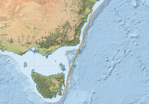
Voyage extents: 43° 16.7' S to 33° 44.2' S 147° 19.8' E to 151° 28.6' E Get voyage track shapefile Get CSV
Marlin Metadata:-
Metadata from OBIS Australia datasets:- biological data is published via the OBIS-AU IPT server and delivered to one or more of OBIS, ALA and GBIF
Download from OBIS Australia IPT View at - Ocean Biodiversity Information System (OBIS) Atlas of Living Australia (ALA) GBIF
Download from OBIS Australia IPT View at - Ocean Biodiversity Information System (OBIS) Atlas of Living Australia (ALA) GBIF
Cruise Summary Report at SeaDataNet:-
Participants - on ship:-
| Name | Role | Organisation | Project |
|---|---|---|---|
| Stephen McCullum | Deputy Voyage Manager | Marine National Facility | Voyage Management on RV Investigator |
| Tegan Sime | Voyage Manager | Marine National Facility | Voyage Management on RV Investigator |
This list includes those that may have only been on part of the voyage. See voyage reports on 'Reports and Maps' tab for details.
Marine National Facility Reports - plans, summaries and data processing
-
IN2015_T01 Voyage Plan
- includes objectives, investigator details, proposed data collection, voyage track and equipment to be used.
-
IN2015_T01 ADCP Data Processing Report
- details of data processing steps, calibration information, instruments used and any issues with the data.
-
IN2015_T01 Underway Data Processing Report
- details of data processing steps, calibration information, instruments used and any issues with the data.
- View Survey map
Publications, reports and datasets from this voyage.
Dataset
- Martin, Tara; Boyd, Matt; Navidad, Cisco; Taylor, Charlie; Plunkett, Tom (2022): IN2015_T01 Hobart to Sydney Transit Bathymetry 10m - 210m Multi-resolution AusSeabed products. v1. CSIRO. Data Collection. 10.25919/hn6v-1817
IPT Resource
- IMOS - Phytoplankton Abundance and Biovolume (CPR), Australia (2007 to present) (Darwin Core Archive) External link to reference
- IMOS - Zooplankton Abundance and Biomass Index (CPR) (Darwin Core Archive) External link to reference
Journal Article
- Hallegraeff, Gustaaf,Eriksen, Ruth,Davies, Claire,Slotwinski, Anita,McEnnulty, Felicity,Coman, Frank,Uribe-Palomino, Julian,Tonks, Mark,Richardson, Anthony (2020) The marine planktonic dinoflagellate Tripos: 60 years of species-level distributions in Australian waters. Australian Systematic Botany pp-. 10.1071/SB19043
- McEnnulty, Felicity R.,Davies, Claire H.,Armstrong, Asia O,Atkins, Natalia,Coman, Frank,Clementson, Lesley,Edgar, Steven,Eriksen, Ruth S.,Everett, Jason D.,Anthony Koslow, J.,Lønborg, Christian,McKinnon, A. David,Miller, Margaret,O’Brien, Todd D.,Pausina, Sarah A.,Uribe-Palomino, Julian,Rochester, Wayne,Rothlisberg, Peter C.,Slotwinski, Anita,Strzelecki, Joanna (2020) A database of zooplankton biomass in Australian marine waters. Scientific Data 7 pp-. 10.1038/s41597-020-00625-9
Search for publications, reports and datasets from this and other voyages
Data publishing
This is a list of online datasets hosted by CSIRO. Other processed datasets hosted by collaborating organisations may be found on the 'Metadata' or "Reports, Publications and Maps' tab.
Use the Get data link on the right to extract data using the NCMI Data Trawler.
| Data Stream | Data Summary | Get data | ||||||||||||||
|---|---|---|---|---|---|---|---|---|---|---|---|---|---|---|---|---|
| ADCP Data |
|
Get Data from Trawler Download ADCP Data (NetCDF, 5 minute) |
||||||||||||||
| Marine biodiversity observations and/or samples |
|
Get Data from Trawler |
||||||||||||||
| Multibeam echosounder |
|
Get Data from Trawler |
||||||||||||||
| pCO2 |
|
External link - download datafile at IMOS Data fields and units document (.pdf) |
||||||||||||||
| Radon measurements |
|
Get Data from Trawler Download RV Investigator Radon dataset (XLSX) |
||||||||||||||
| Sub-bottom profiler |
|
Get Data from Trawler |
||||||||||||||
| Singlebeam echosounder |
|
Get Data from Trawler |
||||||||||||||
| SOOP Bio-acoustics |
|
External link - datafile at IMOS NetCDF Data Format: Manual Download |
||||||||||||||
| Underway |
|
Get Data from Trawler Download 5 minute csv format in2015_t01uwy5min_csv.zip Download 5 second netCDF format in2015_t01uwy_nc.zip Download 10 second csv format in2015_t01uwy10sec_csv.zip |
| ID | When (UTC) | Lat | Long | Instrument | Identifier | Action | Log | Subject / Comment |
|---|
Deployments by start time:- Click on column header to sort. Use link on 'Deployment' to see full details. Use the CSV button at the bottom to export data (tab delimited).
Search for deployments from this voyage and others
| Deployment | Operation | Station | Cast | Gear | Project | Start and end times | Start Location | End Location | Depth range | Max Depth | Description | |||
|---|---|---|---|---|---|---|---|---|---|---|---|---|---|---|
| Underway System [details] | Altimeter-163,Autosal Salinometer,Burket Flow meter,Burket Flow meter,CSIRO Hobart pCO2,CSIRO Hobart pCO2,CSIRO Hobart pCO2,CSIRO Hobart pCO2,CSIRO Hobart pCO2,CSIRO Hobart pCO2,CSIRO Hobart pCO2,CSIRO Hobart pCO2,CSIRO Hobart pCO2,CSIRO Hobart pCO2,CSIRO air sampling inlet,CSIRO air sampling inlet,Chelsea Tech Fluorometer,Gyrocompass,Humidity Sensor-HMT333,Humidity Sensor-HMT333,Humidity Sensor-HMT333,Humidity Sensor-HMT333,IMOS Port Pyranometer-SN 29125F3,IMOS Port Radiometer-SN 29140F3,IMOS Stbd Pyranometer-SN 29125F3,IMOS Stbd Radiometer-SN 29140F3,IMOS wind monitor,IMOS wind monitor,ISAR SST,Kobold MIK-C Flow meter,Kongsberg Maritime Skipper DL850 doppler log,Kongsberg Maritime Skipper DL850 doppler log,Kongsberg Maritime Skipper DL850 doppler log,Kongsberg Maritime Skipper DL850 doppler log,Kongsberg Maritime Skipper DL850 doppler log,Kongsberg Maritime Skipper DL850 doppler log,LI-COR LI-190 Quantum Sensor,LI-COR LI-190 Quantum Sensor,Multiangle Absorption Photometer (MAAP),Multiangle Absorption Photometer (MAAP),Ozone Monitor RVT1,Ozone Monitor RVT1,Ozone Monitor RVT2,Ozone Monitor RVT2,Picarro Greenhouse Gas Spectrometer CO2,CH4,H2o,Picarro Greenhouse Gas Spectrometer CO2,CH4,H2o,Picarro Greenhouse Gas Spectrometer CO2,CH4,H2o,Port drop keel sensor,RM Young 05106 wind monitor-SN 82705,RM Young Rain Gauge,RM Young Wind Sensor Type 05107,RM Young Wind Sensor Type 05107,RM Young Wind Sensor Type 05107,RM Young Wind Sensor Type 05107,RM Young Wind Sensor Type 05108,RM Young Wind Sensor Type 05108,RM Young Wind Sensor Type 05108,RM Young Wind Sensor Type 05108,Remote Temperature (T) - SN 671,Seapath 330+,Seapath 330+,Seapath 330+,Simrad EK60 multi-frequency split-beam echosounder,Starboard drop keel sensor,ThermoSalinoGraph (TSG)-SS-SN 1777,Vaisala Ship's Barometer PTB330 | 2423 | 2015-05-10 05:46 | 2015-05-13 06:06 | -42.8446 | 147.3305 | -33.8681 | 151.2222 | ||||||
| Multibeam echosounder [details] | 2423 | 2015-05-10 10:05 | 2015-05-13 00:05 | -43.2779 | 148.0162 | -33.9619 | 151.3725 | 5304.6 | ||||||
| ADCP Data [details] | Teledyne RDI ADCP 150 kHz,Teledyne RDI ADCP 75 kHz | 2423 | 2015-05-10 22:46 | 2015-05-13 05:51 | -40.8395 | 148.8842 | -33.8651 | 151.2230 | 720.3 | |||||
| Sub-bottom Profiler [details] | 2423 | 2015-05-11 10:13 | 2015-05-11 21:51 | -43.2762 | 148.0548 | -41.0181 | 148.8151 | |||||||