Please login if you have access to particular applications.
Catch Data - from CSIRO surveys.
| CAAB Code: | 37 017007 [taxon report] |
| Scientific Name and Authority: | Iago garricki Fourmanoir & Rivaton, 1979 |
| CAAB category: | 37 - Pisces |
| Standard Name (AS 5300): | Longnose Houndshark |
Distribution map:
View detailed map or click on map to see same.
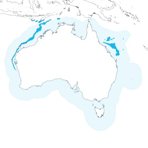
Modelled distribution shown as blue polygon (source: Australian National Fish Expert Distributions) Updated on 2008-11-19.
Occurrence locations [6] shown as red circles - View CSIRO Catch records Get expert distribution shapefile
View detailed map or click on map to see same.
Modelled distribution shown as blue polygon (source: Australian National Fish Expert Distributions) Updated on 2008-11-19.
Occurrence locations [6] shown as red circles - View CSIRO Catch records Get expert distribution shapefile
Catch records - 6 records found.
Click on survey to see survey details. Click on Operation to see full details of the catch. Use the CSV button at the bottom to export data.
| Date (UTC) | Position | Survey | Operation | Depth Range (m) | Count | Weight (kg) | Method | Effort | Gear |
|---|---|---|---|---|---|---|---|---|---|
| 1987-10-12 23:00 | 18° 57.6' S 117° 34.1' E | SO198707 | 133 | 0.17 | 30 minutes | ||||
| 1988-10-12 08:07 | 18° 46.5' S 117° 51.8' E | SO198805 | 189 | 151 to 162 | 0.28 | 30 minutes | |||
| 1989-09-30 02:46 | 20° 01.2' S 115° 31.3' E | POE198901 | 97 | 70 to 72 | 1.04 | 30 minutes | |||
| 1989-10-02 23:56 | 19° 10.1' S 116° 47.1' E | POE198901 | 108 | 166 to 180 | 1.68 | 30 minutes | |||
| 1990-09-28 08:00 | 20° 01.4' S 115° 09.1' E | SS199002 | 45 | 172 to 178 | 1.32 | 30 minutes | |||
| 1991-01-28 08:40 | 24° 51.3' S 112° 07.1' E | SS199101 | 26 | 467 to 478 | 1 | 1.232 | Trawl | 25 minutes |