Voyage details and related metadata, reports, events and data.
SS 04/2004
(alternative identifier: SS200404)
- is a Marine National Facility ![]() voyage
voyage
Period: 2004-04-10 07:00 to 2004-04-29 04:00 UTC
Duration: 18.88 days
From: Hobart To: Sydney
Region: Tasmanian Coast; Bass Strait; Tasman Sea; NSW Coast
Ship: Southern Surveyor [details]
Description:
The scientific objective of this voyage was to test and refine techniques to map and assess seabed habitat developed in a previous CMR project (NOO OP2000-SE02) using the National Facility's newly installed high-resolution EM300 swath mapper.
The sampling locations are a number of submarine canyons on the west coast of Tasmania and east of Bass Strait.
Leader: Dr Alan Williams (CSIRO)
Project: Integrating fishing industry knowledge of fishing grounds with scientific data on seabed habitats for informed spatial management and ESD evaluation in the SEF [details]
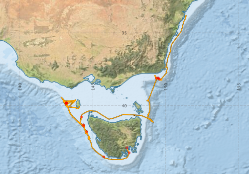
Voyage extents: 43° 42.3' S to 33° 49.8' S 142° 50.4' E to 151° 25.0' E Get voyage track shapefile Get CSV
Marlin Metadata:-
Metadata from OBIS Australia datasets:- biological data is published via the OBIS-AU IPT server and delivered to one or more of OBIS, ALA and GBIF
Download from OBIS Australia IPT View at - Ocean Biodiversity Information System (OBIS) Atlas of Living Australia (ALA) GBIF
Download from OBIS Australia IPT View at - Ocean Biodiversity Information System (OBIS) Atlas of Living Australia (ALA) GBIF
Download from OBIS Australia IPT View at - Ocean Biodiversity Information System (OBIS) Atlas of Living Australia (ALA) GBIF
Download from OBIS Australia IPT View at - Ocean Biodiversity Information System (OBIS)
Participants - on ship:-
| Name | Role | Organisation |
|---|---|---|
| Alan Williams | Chief Investigator | CSIRO Oceans & Atmosphere - Hobart |
| Andrea Cortese | Acoustics data manager | Geoscience Australia |
| Bruce Barker | Voyage Manager; Camera system operations) | CSIRO Oceans & Atmosphere - Hobart |
| Cameron Buchanan | Acoustics data manager | Geoscience Australia |
| Dave Mills | Invertebrate biologist | TAFI |
| Gordon Keith | Acoustics software programmer | CSIRO Oceans & Atmosphere - Hobart |
| Karen Gowlett-Holmes | Invertebrate taxonomist | CSIRO Oceans & Atmosphere - Hobart |
| Lindsay MacDonald | electronics support | CSIRO Oceans & Atmosphere - Hobart |
| Mark Lewis | Gear technologist; camera systems support | CSIRO Oceans & Atmosphere - Hobart |
| Matt Sherlock | (Electronics engineer; camera system operations | CSIRO Oceans & Atmosphere - Hobart |
| Michele Spinoccia | Acoustics data support | Geoscience Australia |
| Miroslaw Ryba | computing support | CSIRO Oceans & Atmosphere - Hobart |
| Pamela Brodie | Data manager; ADCP/LADCP support | CSIRO Oceans & Atmosphere - Hobart |
| Robin Wilson | Invertebrate taxonomist | Museum Victoria |
This list includes those that may have only been on part of the voyage. See voyage reports on 'Reports and Maps' tab for details.
Marine National Facility Reports - plans, summaries and data processing
-
SS200404 Voyage Plan
- includes objectives, investigator details, proposed data collection, voyage track and equipment to be used.
-
SS200404 Underway Data Processing Report
- details of data processing steps, calibration information, instruments used and any issues with the data.
-
SS200404 Voyage Summary
- includes preliminary results, voyage narrative, types of data collected with C77/ROSCOP codes.
-

Publications, reports and datasets from this voyage.
IPT Resource
- Australian National Fish Collection (ANFC) (Darwin Core Archive) External link to reference
- CSIRO Marine Invertebrate Image Collection (MIIC) (Darwin Core Archive) External link to reference
- CSIRO, Cruise SS200404, Benthic Biodiversity, Tasmanian Coast; Bass Strait; Tasman Sea; NSW Coast, 2004 (Darwin Core Archive) External link to reference
- Global benthic biogeographical regions and macroecological drivers for ophiuroids [Data set] (Darwin Core Archive) External link to reference
Journal Article
- Glasby, C. J. and Marks, S. (2013) Revision of the genus Synelmis Chameberlin, 1919 (Annelida: Phyllodocida: Pilargidae) in Australia. Zootaxa 3646 516-574 10.11646/zootaxa.3646.5.5
- Power, H. E.,Clarke, S. L. (2019) 3D seismic-derived bathymetry: a quantitative comparison with multibeam data. Geo-Marine Letters 39 pp447-467. 10.1007/s00367-019-00596-w
- Schlacher, T. A., Schlacher-Hoenliger, M. A., Williams, A., Althaus, F., Hooper, J. N. A. and Kloser, R. (2007) Richness and distribution of sponge megabenthos in continental margin canyons off southeastern Australia. Marine Ecology Progress Series 340 73-88 10.3354/meps340073
- Schlacher, T. A., Williams, A., Althaus, F. and Schlacher-Hoenliger, M. A. (2010) High-resolution seabed imagery as a tool for biodiversity conservation planning on continental margins. Marine Ecology (an Evolutionary Perspective) 31 200-221 10.1111/j.1439-0485.2009.00286.x
Search for publications, reports and datasets from this and other voyages
Data publishing
This is a list of online datasets hosted by CSIRO. Other processed datasets hosted by collaborating organisations may be found on the 'Metadata' or "Reports, Publications and Maps' tab.
Use the Get data link on the right to extract data using the NCMI Data Trawler.
| Data Stream | Data Summary | Get data | ||||||||||||||
|---|---|---|---|---|---|---|---|---|---|---|---|---|---|---|---|---|
| ADCP Data |
|
Get Data from Trawler Download dataset 2.1 / 0.5 Mb Processing report for this dataset |
||||||||||||||
| Marine biodiversity observations and/or samples |
|
Get Data from Trawler |
||||||||||||||
| Catch Details |
|
Get Data from Trawler |
||||||||||||||
| Multibeam echosounder |
|
Get Data from Trawler |
||||||||||||||
| Underway |
|
Get Data from Trawler |
Deployments by start time:- Click on column header to sort. Use link on 'Deployment' to see full details. Use the CSV button at the bottom to export data (tab delimited).
Search for deployments from this voyage and others
| Deployment | Operation | Station | Cast | Gear | Project | Start and end times | Start Location | End Location | Depth range | Max Depth | Description | |||
|---|---|---|---|---|---|---|---|---|---|---|---|---|---|---|
| Multibeam echosounder [details] | EM300 Multibeam Echosounder | 2004-04-10 07:09 | 2004-04-27 13:16 | -42.8864 | 147.3406 | -38.2029 | 149.5164 | 5528.7 | ||||||
| Underway System [details] | Air Temperature Sensor-HMP233,Barometer,Fluorometer WS3S-026,Gyro-Generic SS-NF,Humidity Sensor-HMP233,Licor-UWQ 3708,RM Young 05103 wind monitor,RM Young 05103 wind monitor,RM Young 05103 wind monitor,Seapath 200,Seapath 200,Simrad EA500 Echosounder,ThermoSalinoGraph (TSG)-SS-SN 1777,ThermoSalinoGraph (TSG)-SS-SN 1777 | 1193 | 2004-04-10 09:17 | 2004-04-29 02:09 | -43.2385 | 147.4936 | -33.8307 | 151.3083 | ||||||
| ADCP Data [details] | RDI VM-150 Acoustic Doppler current profiler | 1625 | 2004-04-11 00:20 | 2004-04-28 20:00 | -43.5140 | 145.7480 | -34.4320 | 151.1780 | 400.8 | |||||
| CTD Cast [details] | 2 | Cast | CTD (Southern Surveyor) | 2004-04-11 02:12 | 2004-04-11 03:15 | -43.4777 | 145.6245 | -43.4707 | 145.6238 | |||||
| CTD Cast [details] | 8 | Cast | CTD (Southern Surveyor) | 2004-04-12 06:57 | 2004-04-12 07:21 | -41.7935 | 144.5560 | |||||||
| CTD Cast [details] | 9 | Cast | CTD (Southern Surveyor) | 2004-04-12 07:45 | 2004-04-12 08:09 | -41.7952 | 144.5373 | |||||||
| CTD Cast [details] | 15 | Cast | CTD (Southern Surveyor) | 2004-04-13 10:12 | 2004-04-13 10:34 | -40.0645 | 143.2367 | |||||||
| CTD Cast [details] | 16 | Cast | CTD (Southern Surveyor) | 2004-04-16 10:36 | 2004-04-16 10:45 | -39.6915 | 143.7073 | |||||||
| Catch [details] | 25 | Benthic sled,Sherman epibenthic Sled | 1625 | 2004-04-16 13:47 | 2004-04-16 15:07 | -39.8256 | 143.2667 | -39.8279 | 143.3006 | |||||
| Catch [details] | 27 | Benthic sled,Sherman epibenthic Sled | 1625 | 2004-04-17 03:48 | 2004-04-17 04:27 | -39.8527 | 143.1739 | -39.8758 | 143.1716 | |||||
| Catch [details] | 28 | Benthic sled,Sherman epibenthic Sled | 1625 | 2004-04-17 05:33 | 2004-04-17 06:40 | -39.8814 | 143.1444 | -39.9095 | 143.5181 | |||||
| Catch [details] | 29 | Benthic sled,Sherman epibenthic Sled | 1625 | 2004-04-17 07:49 | 2004-04-17 08:21 | -39.8679 | 143.1727 | -39.8909 | 143.1807 | |||||
| Catch [details] | 30 | Benthic sled,Sherman epibenthic Sled | 1625 | 2004-04-17 14:00 | 2004-04-17 14:58 | -39.8553 | 143.1724 | -39.9001 | 143.1754 | |||||
| Video [details] | 32 | Shallow Video System | 2004-04-18 05:17 | 2004-04-18 07:01 | -39.8191 | 143.1763 | -39.8694 | 143.1688 | ||||||
| Video [details] | 1625 | 2004-04-18 05:17 | 2004-04-18 06:12 | -39.8175 | 143.1757 | -39.8402 | 143.1724 | 456.9 | ||||||
| Video [details] | 33 | Shallow Video System | 2004-04-18 06:57 | 2004-04-18 08:25 | -39.8676 | 143.1672 | -39.9102 | 143.1435 | ||||||
| Video [details] | 1625 | 2004-04-18 07:04 | 2004-04-18 08:17 | -39.8689 | 143.1670 | -39.9041 | 143.1517 | 529.4 | ||||||
| Catch [details] | 34 | Benthic sled,Sherman epibenthic Sled | 1625 | 2004-04-18 10:16 | 2004-04-18 10:40 | -39.8565 | 143.1849 | -39.8769 | 143.1774 | |||||
| Catch [details] | 35 | Benthic sled,Sherman epibenthic Sled | 1625 | 2004-04-18 12:53 | 2004-04-18 14:15 | -39.8113 | 143.1466 | -39.8465 | 143.1242 | |||||
| Catch [details] | 36 | Benthic sled,Rock Dredge | 1625 | 2004-04-18 15:44 | 2004-04-18 16:22 | -39.8417 | 143.1702 | -39.8331 | 143.1691 | |||||
| Catch [details] | 37 | Benthic sled,Rock Dredge | 1625 | 2004-04-18 17:13 | 2004-04-18 17:30 | -39.8086 | 143.1447 | -39.8044 | 143.1412 | |||||
| Catch [details] | 38 | Benthic sled,Rock Dredge | 1625 | 2004-04-18 18:04 | 2004-04-18 18:36 | -39.8152 | 143.1531 | -39.8068 | 143.1405 | |||||
| Video [details] | 39 | EM300 Multibeam Echosounder | 2004-04-18 20:03 | 2004-04-18 21:44 | -39.7963 | 143.1907 | ||||||||
| Video [details] | 1625 | 2004-04-18 20:18 | 2004-04-18 21:35 | -39.8015 | 143.1834 | -39.8210 | 143.1488 | 419.1 | ||||||
| Video [details] | 40 | Shallow Video System | 2004-04-18 22:53 | 2004-04-19 00:50 | -39.8219 | 143.1646 | -39.8572 | 143.1222 | ||||||
| Video [details] | 1625 | 2004-04-18 23:04 | 2004-04-19 00:36 | -39.8258 | 143.1628 | -39.8500 | 143.1364 | 570.9 | ||||||
| Video [details] | 41 | Shallow Video System | 2004-04-19 02:35 | 2004-04-19 04:35 | -39.8304 | 143.2377 | -39.8276 | 143.1586 | ||||||
| Video [details] | 1625 | 2004-04-19 02:41 | 2004-04-19 04:21 | -39.8304 | 143.2340 | -39.8293 | 143.1757 | 310.6 | ||||||
| Catch [details] | 42 | Smith-McIntyre Grab 0.1cu.m. | 1625 | 2004-04-19 05:17 | 2004-04-19 05:31 | -39.8258 | 143.1955 | -39.8247 | 143.1957 | |||||
| Catch [details] | 43 | Smith-McIntyre Grab 0.1cu.m. | 1625 | 2004-04-19 05:44 | 2004-04-19 05:53 | -39.8248 | 143.1957 | |||||||
| Catch [details] | 44 | Smith-McIntyre Grab 0.1cu.m. | 1625 | 2004-04-19 06:03 | 2004-04-19 06:11 | -39.8248 | 143.1943 | |||||||
| Catch [details] | 45 | Benthic sled,Sherman epibenthic Sled | 1625 | 2004-04-19 06:53 | 2004-04-19 07:21 | -39.8280 | 143.2126 | -39.8307 | 143.2332 | |||||
| CTD Cast [details] | 46 | Cast | CTD (Southern Surveyor) | 2004-04-19 08:18 | 2004-04-19 08:43 | -39.8434 | 143.1381 | |||||||
| CTD Cast [details] | 47 | Cast | CTD (Southern Surveyor) | 2004-04-19 09:33 | 2004-04-19 10:06 | -39.8434 | 143.1381 | |||||||
| CTD Cast [details] | 48 | Cast | CTD (Southern Surveyor) | 2004-04-19 10:36 | 2004-04-19 11:03 | -39.8565 | 143.1603 | |||||||
| Video [details] | 49 | Shallow Video System | 2004-04-20 00:32 | 2004-04-20 03:18 | -41.3124 | 144.3512 | -41.3455 | 144.3231 | ||||||
| Video [details] | 1625 | 2004-04-20 00:38 | 2004-04-20 01:58 | -41.3146 | 144.3501 | -41.3432 | 144.3217 | 250.3 | ||||||
| Catch [details] | 50 | Benthic sled,Sherman epibenthic Sled | 1625 | 2004-04-20 05:18 | 2004-04-20 06:09 | -41.3654 | 144.4241 | -41.3836 | 144.3784 | |||||
| Catch [details] | 51 | Benthic sled,Sherman epibenthic Sled | 1625 | 2004-04-20 06:55 | 2004-04-20 08:10 | -41.3777 | 144.3923 | -41.4049 | 144.3210 | |||||
| Catch [details] | 52 | Benthic sled,Sherman epibenthic Sled | 1625 | 2004-04-20 10:27 | 2004-04-20 11:40 | -41.3300 | 144.3333 | -41.3587 | 144.3147 | |||||
| CTD Cast [details] | 54 | Cast | CTD (Southern Surveyor) | 2004-04-20 15:01 | 2004-04-20 15:33 | -41.3695 | 144.3367 | |||||||
| Catch [details] | 55 | Benthic sled,Rock Dredge | 1625 | 2004-04-20 15:45 | 2004-04-20 16:45 | -41.3744 | 144.3416 | -41.3345 | 144.3316 | |||||
| Catch [details] | 57 | Smith-McIntyre Grab 0.1cu.m. | 1625 | 2004-04-20 20:18 | 2004-04-20 20:25 | -41.7292 | 144.5757 | |||||||
| Catch [details] | 58 | Smith-McIntyre Grab 0.1cu.m. | 1625 | 2004-04-20 20:42 | 2004-04-20 20:46 | -41.7239 | 144.5812 | -41.7237 | 144.5821 | |||||
| Catch [details] | 59 | Smith-McIntyre Grab 0.1cu.m. | 1625 | 2004-04-20 20:59 | 2004-04-20 21:04 | -41.7241 | 144.5783 | -41.7247 | 144.5774 | |||||
| Catch [details] | 60 | Smith-McIntyre Grab 0.1cu.m. | 1625 | 2004-04-20 22:18 | 2004-04-20 22:24 | -41.7831 | 144.6042 | -41.7848 | 144.6027 | |||||
| Catch [details] | 61 | Smith-McIntyre Grab 0.1cu.m. | 1625 | 2004-04-20 22:49 | 2004-04-20 22:54 | -41.7794 | 144.6008 | -41.7798 | 144.6010 | |||||
| Catch [details] | 62 | Smith-McIntyre Grab 0.1cu.m. | 1625 | 2004-04-20 23:08 | 2004-04-20 23:13 | -41.7757 | 144.6014 | -41.7769 | 144.6001 | |||||
| Video [details] | 63 | Shallow Video System | 2004-04-21 02:51 | 2004-04-21 05:55 | -41.7924 | 144.5852 | -41.7397 | 144.5536 | ||||||
| Video [details] | 1625 | 2004-04-21 02:57 | 2004-04-21 05:51 | -41.7913 | 144.5849 | -41.7390 | 144.5534 | 473.1 | ||||||
| Catch [details] | 65 | Benthic sled,Sherman epibenthic Sled | 1625 | 2004-04-21 08:02 | 2004-04-21 09:01 | -41.7776 | 144.5750 | -41.7592 | 144.5626 | |||||
| Catch [details] | 66 | Smith-McIntyre Grab 0.1cu.m. | 1625 | 2004-04-21 11:34 | 2004-04-21 11:50 | -41.9776 | 144.6743 | |||||||
| Catch [details] | 67 | Smith-McIntyre Grab 0.1cu.m. | 1625 | 2004-04-21 12:05 | 2004-04-21 12:12 | -41.9784 | 144.6709 | -41.9778 | 144.6705 | |||||
| Catch [details] | 68 | Smith-McIntyre Grab 0.1cu.m. | 1625 | 2004-04-21 12:29 | 2004-04-21 12:25 | -41.9749 | 144.6696 | -41.9756 | 144.6698 | |||||
| Catch [details] | 69 | Smith-McIntyre Grab 0.1cu.m. | 1625 | 2004-04-21 13:46 | 2004-04-21 13:51 | -41.9455 | 144.6665 | -41.9463 | 144.6663 | |||||
| Catch [details] | 70 | Smith-McIntyre Grab 0.1cu.m. | 1625 | 2004-04-21 14:11 | 2004-04-21 14:17 | -41.9449 | 144.6652 | -41.9463 | 144.6644 | |||||
| Catch [details] | 71 | Smith-McIntyre Grab 0.1cu.m. | 1625 | 2004-04-21 14:27 | 2004-04-21 14:35 | -41.9449 | 144.6668 | -41.9450 | 144.6670 | |||||
| Catch [details] | 72 | Benthic sled,Sherman epibenthic Sled | 1625 | 2004-04-21 16:35 | 2004-04-21 17:53 | -41.7951 | 144.5859 | -41.7477 | 144.5555 | |||||
| Catch [details] | 73 | Benthic sled,Sherman epibenthic Sled | 1625 | 2004-04-21 19:33 | 2004-04-21 21:03 | -41.7396 | 144.5598 | -41.7944 | 144.5616 | |||||
| Video [details] | 75 | Shallow Video System | 2004-04-22 02:31 | 2004-04-22 04:50 | -41.4095 | 144.3808 | -41.3628 | 144.3824 | ||||||
| Video [details] | 1625 | 2004-04-22 02:44 | 2004-04-22 04:35 | -41.4072 | 144.3797 | -41.3738 | 144.3764 | 577.9 | ||||||
| CTD Cast [details] | 77 | Cast | CTD (Southern Surveyor) | 2004-04-22 10:44 | 2004-04-22 10:53 | -40.7000 | 144.2419 | -40.7010 | 144.2425 | |||||
| Catch [details] | 78 | Benthic sled,Sherman epibenthic Sled | 1625 | 2004-04-22 16:11 | 2004-04-22 16:53 | -40.7927 | 144.2192 | -40.7628 | 144.2273 | |||||
| Video [details] | 80 | Shallow Video System | 2004-04-22 18:17 | 2004-04-22 18:45 | -40.7753 | 144.2272 | -40.7855 | 144.2156 | ||||||
| Video [details] | 1625 | 2004-04-22 18:22 | 2004-04-22 18:40 | -40.7768 | 144.2258 | -40.7830 | 144.2178 | 95 | ||||||
| Catch [details] | 82 | Benthic sled,Sherman epibenthic Sled | 1625 | 2004-04-25 05:10 | 2004-04-25 06:19 | -40.6402 | 148.7878 | -40.6869 | 148.8076 | |||||
| CTD Cast [details] | 83 | Cast | CTD (Southern Surveyor) | 2004-04-25 13:43 | 2004-04-25 14:14 | -39.6449 | 148.8197 | -39.6468 | 148.8209 | |||||
| Video [details] | 84 | Shallow Video System | 2004-04-26 01:31 | 2004-04-26 04:32 | -38.1137 | 149.3592 | -38.1797 | 149.3188 | ||||||
| Video [details] | 1625 | 2004-04-26 01:40 | 2004-04-26 04:22 | -38.1159 | 149.3566 | -38.1742 | 149.3244 | 370 | ||||||
| Catch [details] | 86 | Benthic sled,Sled - Combination | 1625 | 2004-04-26 06:21 | 2004-04-26 06:52 | |||||||||
| Catch [details] | 88 | Benthic sled,Sherman epibenthic Sled | 1625 | 2004-04-26 13:18 | 2004-04-26 14:44 | -38.1148 | 149.3565 | -38.1650 | 149.3387 | |||||
| CTD Cast [details] | 89 | Cast | CTD (Southern Surveyor) | 2004-04-26 16:06 | 2004-04-26 16:47 | |||||||||
| Video [details] | 90 | Shallow Video System | 2004-04-26 17:48 | 2004-04-26 19:02 | -38.1752 | 149.5619 | -38.2039 | 149.5441 | ||||||
| Video [details] | 1625 | 2004-04-26 17:58 | 2004-04-26 18:47 | -38.1781 | 149.5604 | -38.1917 | 149.5526 | 449.4 | ||||||
| Video [details] | 92 | Shallow Video System | 2004-04-26 22:06 | 2004-04-26 23:59 | -38.1199 | 149.5048 | -38.1571 | 149.4682 | ||||||
| Video [details] | 1625 | 2004-04-26 22:14 | 2004-04-26 23:37 | -38.1202 | 149.5016 | -38.1508 | 149.4842 | 457.8 | ||||||
| Video [details] | 93 | Shallow Video System | 2004-04-27 01:06 | 2004-04-27 03:28 | -38.0895 | 149.4686 | -38.1427 | 149.4178 | ||||||
| Video [details] | 1625 | 2004-04-27 01:14 | 2004-04-27 02:55 | -38.0918 | 149.4646 | -38.1251 | 149.4421 | 462.8 | ||||||
| Catch [details] | 94 | Benthic sled,Sherman epibenthic Sled | 1625 | 2004-04-27 06:11 | 2004-04-27 07:15 | -38.1943 | 149.5350 | -38.2285 | 149.5355 | |||||
| CTD Cast [details] | 96 | Cast | CTD (Southern Surveyor) | 2004-04-27 09:10 | 2004-04-27 09:42 | -38.1660 | 149.4648 | |||||||
| CTD Cast [details] | 97 | Cast | CTD (Southern Surveyor) | 2004-04-27 10:09 | 2004-04-27 10:30 | -38.1447 | 149.4753 | |||||||
| CTD Cast [details] | 98 | Cast | CTD (Southern Surveyor) | 2004-04-27 11:01 | 2004-04-27 11:17 | -38.1167 | 149.4908 | |||||||
| CTD Cast [details] | 99 | Cast | CTD (Southern Surveyor) | 2004-04-27 11:36 | 2004-04-27 11:50 | -38.1015 | 149.5005 | |||||||
| Catch [details] | 100 | Benthic sled,Sherman epibenthic Sled | 1625 | 2004-04-27 13:00 | 2004-04-27 15:25 | -38.1922 | 149.5159 | -38.2289 | 149.5147 | |||||
| Catch [details] | 102 | Benthic sled,Sled - Combination | 1625 | 2004-04-28 03:14 | 2004-04-28 03:41 | -37.2895 | 150.0709 | -37.2755 | 150.0717 | |||||