Survey details and related metadata, reports, events and data.
SS 07/97 (alternative identifier: SS199707)
Period: 1997-08-07 00:00 to 1997-09-01 00:00 UTC
Duration: 25.00 days
From: Dampier To: Broome
Region: Australian North West Shelf
Ship: Southern Surveyor [details]
Description: Southern Surveyor cruise SS 07/97 was the eighth in a series studying the changes in abundance of benthos and fish species following the establishment of an experimental management program on the Australian North West Shelf. Cruise objectives were to study the demersal fish community and demersal habitats (based on epibenthic fauna) in each of the three experimental mmanagement zones; to collect data and samples for studying recruitment, growth, and mortality of fish species; to collect SDL (submersible data logger) transects; to obtain taxonomic specimens and photographs of fish and invertebrate species; and to collect additional fish specimens from deeper water trawling. Whale-watches from Environment Australia also used the cruise for whale observations. Length-frequency data were collected for 14 species of fish, and numerous otolith samples collected from four major species. 35mm photography was carried out on some 50% of the random trawl stations.
Leader: A.W. Whitelaw (CSIRO)
Project: North West Shelf Demersal Marine Resources Study (1982-1992) [details]
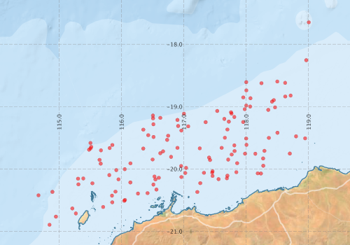
Voyage extents: 20° 53.7' S to 18° 15.4' S 114° 50.8' E to 118° 57.8' E
Marlin Metadata:-
Metadata from OBIS Australia datasets:- biological data is published via the OBIS-AU IPT server and delivered to one or more of OBIS, ALA and GBIF
Download from OBIS Australia IPT View at - Ocean Biodiversity Information System (OBIS) Atlas of Living Australia (ALA) GBIF
Download from OBIS Australia IPT View at - Ocean Biodiversity Information System (OBIS) Atlas of Living Australia (ALA) GBIF
Download from OBIS Australia IPT View at - Ocean Biodiversity Information System (OBIS) Atlas of Living Australia (ALA) GBIF
Participants - on ship:-
| Name | Leg | Role | Organisation |
|---|---|---|---|
| Alistair Graham | 1 | CMAR | |
| B Oneil | 2 | Env. Aust. | |
| C Stanley | 1 2 | CMAR | |
| Cherry | 1 2 | CMAR | |
| Chris Burdon | 1 2 | Whales | Western Australian Museum (Perth) |
| G Dews | 1 2 | CMARCMAR | |
| G West | 2 | CMAR | |
| H Webb | 1 | CMAR | |
| Jeff Cordell | 1 | CMAR | |
| Justy Siwabessy | 1 | Acoustics | University of Western Australia |
| K Evans | 1 | Env. Aust. | |
| Lindsay MacDonald | 2 | CMAR | |
| R Campbell | 2 | CMAR | |
| Steve Newman | 2 | WA Department of Fisheries | |
| T Hay | 2 | Northern Territory Department of Primary Industry, Fisheries and Mines | |
| Wade Whitelaw | 1 2 | Cruise leader | CMAR |
This list includes those that may have only been on part of the voyage. See voyage reports on 'Reports and Maps' tab for details.
Marine National Facility Reports - plans, summaries and data processing
-
SS199707 Voyage Summary
- includes preliminary results, voyage narrative, types of data collected with C77/ROSCOP codes.
-
SS199707 Voyage Plan
- includes objectives, investigator details, proposed data collection, voyage track and equipment to be used.
-

Publications, reports and datasets from this voyage.
Dataset
- Appleyard, Sharon; Ward, Robert; Pogonoski, John; Graham, Alastair; Last, Peter; Deagle, Bruce; & Holmes, Bronwyn (2024): Marine fishes (from Australia) COI barcode reference library. v2. CSIRO. Data Collection. 10.25919/8haz-aa91
IPT Resource
- Australian National Fish Collection (ANFC) (Darwin Core Archive) External link to reference
- CSIRO, North West Shelf Demersal Marine Resources Study 1980-1997 (Darwin Core Archive) External link to reference
- Identifications of marine organisms from towed photo cameras, Kimberleys, Western Australia (1983-1997) (Darwin Core Archive) External link to reference
Search for publications, reports and datasets from this and other voyages
Data publishing
This is a list of online datasets hosted by CSIRO. Other processed datasets hosted by collaborating organisations may be found on the 'Metadata' or "Reports, Publications and Maps' tab.
Use the Get data link on the right to extract data using the NCMI Data Trawler.
| Data Stream | Data Summary | Get data | ||||||||||||
|---|---|---|---|---|---|---|---|---|---|---|---|---|---|---|
| Marine biodiversity observations and/or samples |
|
Get Data from Trawler |
||||||||||||
| Catch Details (deprecated - now bio) |
|
Get Data from Trawler |
Deployments by start time:- Click on column header to sort. Use link on 'Deployment' to see full details. Use the CSV button at the bottom to export data (tab delimited).
Search for deployments from this voyage and others
| Deployment | Operation | Station | Cast | Gear | Project | Start and end times | Start Location | End Location | Depth range | Max Depth | Description | |||
|---|---|---|---|---|---|---|---|---|---|---|---|---|---|---|
| Catch [details] | 1 | Demersal Frank & Bryce trawl | 171 | 1997-08-07 09:00 | 1997-08-07 09:30 | -20.1300 | 116.9617 | -20.0983 | 116.9733 | 44 to 45 | 45 | |||
| Catch [details] | 2 | Demersal Frank & Bryce trawl | 171 | 1997-08-07 23:00 | 1997-08-07 23:30 | -19.9833 | 117.0367 | -20.0067 | 117.0717 | 50 to 49 | 50 | |||
| Catch [details] | 3 | Demersal Frank & Bryce trawl | 171 | 1997-08-08 01:10 | 1997-08-08 01:40 | -20.0650 | 117.0233 | -20.0350 | 117.0450 | 47 to 50 | 50 | |||
| Catch [details] | 4 | Demersal Frank & Bryce trawl | 171 | 1997-08-08 03:15 | 1997-08-08 03:45 | -19.9533 | 116.9567 | 56 to 56 | 56 | |||||
| Catch [details] | 5 | Demersal Frank & Bryce trawl | 171 | 1997-08-08 05:44 | 1997-08-08 06:14 | -19.8067 | 116.7967 | -19.8300 | 116.8067 | 69 to 68 | 69 | |||
| Catch [details] | 6 | Demersal Frank & Bryce trawl | 171 | 1997-08-08 08:00 | 1997-08-08 08:30 | -19.6617 | 116.8983 | -19.6267 | 116.8917 | 74 to 74 | 74 | |||
| Catch [details] | 7 | Demersal Frank & Bryce trawl | 171 | 1997-08-08 23:13 | 1997-08-08 23:43 | -19.1133 | 117.0017 | 196 to 187 | 196 | |||||
| Catch [details] | 8 | Demersal Frank & Bryce trawl | 171 | 1997-08-09 01:30 | 1997-08-09 02:00 | -19.2150 | 116.8983 | -19.1967 | 116.9183 | 156 to 164 | 164 | |||
| Catch [details] | 9 | Demersal Frank & Bryce trawl | 171 | 1997-08-09 03:20 | 1997-08-09 03:50 | -19.3117 | 116.9100 | -19.3233 | 116.9400 | 114 to 111 | 114 | |||
| Catch [details] | 10 | Demersal Frank & Bryce trawl | 171 | 1997-08-09 04:55 | 1997-08-09 05:25 | -19.3167 | 117.0717 | -19.3333 | 117.1133 | 109 to 112 | 112 | |||
| Catch [details] | 11 | Demersal Frank & Bryce trawl | 171 | 1997-08-09 06:55 | 1997-08-09 07:25 | -19.3850 | 116.9617 | -19.3517 | 116.9833 | 114 to 109 | 114 | |||
| Catch [details] | 12 | Demersal Frank & Bryce trawl | 171 | 1997-08-09 23:10 | 1997-08-09 23:40 | -19.4667 | 116.7500 | -19.4517 | 116.7900 | 72 to 90 | 90 | |||
| Catch [details] | 13 | Demersal Frank & Bryce trawl | 171 | 1997-08-10 01:20 | 1997-08-10 01:50 | -19.5333 | 116.7333 | -19.5700 | 116.7300 | 50 to 50 | 50 | |||
| Catch [details] | 14 | Demersal Frank & Bryce trawl | 171 | 1997-08-10 03:05 | 1997-08-10 03:35 | -19.7183 | 116.6683 | -19.7467 | 116.6617 | 49 to 48 | 49 | |||
| Catch [details] | 15 | Demersal Frank & Bryce trawl | 171 | 1997-08-10 04:10 | 1997-08-10 04:40 | -19.7483 | 116.6233 | -19.7283 | 116.5983 | 53 to 55 | 55 | |||
| Catch [details] | 16 | Demersal Frank & Bryce trawl | 171 | 1997-08-10 06:43 | 1997-08-10 07:13 | -19.8483 | 116.5000 | -19.8700 | 116.5167 | 63 to 61 | 63 | |||
| Catch [details] | 17 | Demersal Frank & Bryce trawl | 171 | 1997-08-10 08:35 | 1997-08-10 09:05 | -20.1417 | 116.6000 | -20.1667 | 116.6117 | 49 to 48 | 49 | |||
| Catch [details] | 18 | CTD (Southern Surveyor) | 171 | 1997-08-10 10:46 | -20.1217 | 116.5300 | 50 | |||||||
| Catch [details] | 19 | CTD (Southern Surveyor) | 171 | 1997-08-10 14:34 | -19.4867 | 116.5150 | 99 | |||||||
| Catch [details] | 20 | CTD (Southern Surveyor) | 171 | 1997-08-10 15:59 | -19.2833 | 116.5133 | 150 | |||||||
| Catch [details] | 21 | CTD (Southern Surveyor) | 171 | 1997-08-10 16:55 | -19.1900 | 116.5067 | 202 | |||||||
| Catch [details] | 22 | CTD (Southern Surveyor) | 171 | 1997-08-10 17:40 | -19.1433 | 116.5050 | 253 | |||||||
| Catch [details] | 23 | Demersal Frank & Bryce trawl | 171 | 1997-08-10 23:45 | 1997-08-11 00:15 | -19.1817 | 116.6233 | -19.1917 | 116.5950 | 200 to 196 | 200 | |||
| Catch [details] | 24 | Demersal Frank & Bryce trawl | 171 | 1997-08-11 02:15 | 1997-08-11 02:45 | -19.3700 | 116.3517 | -19.3733 | 116.3217 | 28 to 28 | 28 | |||
| Catch [details] | 25 | Demersal Frank & Bryce trawl | 171 | 1997-08-11 04:25 | 1997-08-11 04:55 | -19.4583 | 116.4300 | -19.4850 | 116.4133 | 116 to 114 | 116 | |||
| Catch [details] | 26 | Demersal Frank & Bryce trawl | 171 | 1997-08-11 06:30 | 1997-08-11 07:00 | -19.6733 | 116.3500 | -19.7067 | 116.3317 | 67 to 66 | 67 | |||
| Catch [details] | 27 | Demersal Frank & Bryce trawl | 171 | 1997-08-11 23:10 | 1997-08-11 23:40 | -19.9100 | 116.1450 | -19.9317 | 116.1717 | 65 to 64 | 65 | |||
| Catch [details] | 28 | Demersal Frank & Bryce trawl | 171 | 1997-08-12 00:45 | 1997-08-12 01:15 | -20.0033 | 116.0533 | -20.0333 | 116.0683 | 60 to 58 | 60 | |||
| Catch [details] | 29 | Demersal Frank & Bryce trawl | 171 | 1997-08-12 02:25 | 1997-08-12 02:55 | -20.0183 | 115.9183 | -20.0600 | 115.8983 | 65 to 64 | 65 | |||
| Catch [details] | 30 | Demersal Frank & Bryce trawl | 171 | 1997-08-12 03:50 | 1997-08-12 04:20 | -20.0983 | 115.8050 | -20.0883 | 115.7733 | 63 to 65 | 65 | |||
| Catch [details] | 31 | Demersal Frank & Bryce trawl | 171 | 1997-08-12 06:00 | 1997-08-12 06:30 | -20.1667 | 115.9533 | -20.1917 | 115.9367 | 56 to 56 | 56 | |||
| Catch [details] | 32 | Demersal Frank & Bryce trawl | 171 | 1997-08-12 08:13 | 1997-08-12 08:43 | -20.2167 | 116.1433 | -20.1917 | 116.1533 | 50 to 50 | 50 | |||
| Catch [details] | 33 | Demersal Frank & Bryce trawl | 171 | 1997-08-12 23:10 | 1997-08-12 23:40 | -20.7133 | 115.2700 | -20.7400 | 115.2567 | 43 to 43 | 43 | |||
| Catch [details] | 34 | Demersal Frank & Bryce trawl | 171 | 1997-08-13 00:55 | 1997-08-13 01:25 | -20.6333 | 115.2133 | -20.6583 | 115.2067 | 50 to 49 | 50 | |||
| Catch [details] | 35 | Demersal Frank & Bryce trawl | 171 | 1997-08-13 03:12 | 1997-08-13 03:42 | -20.7650 | 114.9500 | -20.7917 | 114.9383 | 92 to 92 | 92 | |||
| Catch [details] | 36 | Demersal Frank & Bryce trawl | 171 | 1997-08-13 05:05 | 1997-08-13 05:35 | -20.8950 | 114.8467 | -20.8500 | 114.8550 | 102 to 101 | 102 | |||
| Catch [details] | 37 | Demersal Frank & Bryce trawl | 171 | 1997-08-13 08:40 | 1997-08-13 09:10 | -20.3683 | 114.8933 | -20.4100 | 114.8883 | 175 to 163 | 175 | |||
| Catch [details] | 38 | Demersal Frank & Bryce trawl | 171 | 1997-08-13 13:00 | -20.4233 | 114.6700 | 806 | |||||||
| Catch [details] | 39 | Demersal Frank & Bryce trawl | 171 | 1997-08-13 23:05 | 1997-08-13 23:35 | -19.9150 | 115.6683 | -19.9117 | 115.7067 | 79 to 74 | 79 | |||
| Catch [details] | 40 | Demersal Frank & Bryce trawl | 171 | 1997-08-14 01:45 | 1997-08-14 02:15 | -19.8550 | 115.6500 | -19.8600 | 115.6133 | 73 to 76 | 76 | |||
| Catch [details] | 41 | Demersal Frank & Bryce trawl | 171 | 1997-08-14 03:45 | 1997-08-14 04:15 | -19.7017 | 115.6717 | -19.8317 | 115.7150 | 179 to 146 | 179 | |||
| Catch [details] | 42 | Demersal Frank & Bryce trawl | 171 | 1997-08-14 05:42 | 1997-08-14 06:12 | -19.6650 | 115.8117 | -19.6383 | 115.8250 | 131 to 135 | 135 | |||
| Catch [details] | 43 | Demersal Frank & Bryce trawl | 171 | 1997-08-14 07:15 | 1997-08-14 07:45 | -19.6167 | 115.8550 | -19.6200 | 115.8283 | 137 to 138 | 138 | |||
| Catch [details] | 44 | CTD (Southern Surveyor) | 171 | 1997-08-14 10:26 | -19.5833 | 115.5033 | 252 | |||||||
| Catch [details] | 45 | CTD (Southern Surveyor) | 171 | 1997-08-14 11:36 | -19.6467 | 115.5167 | 203 | |||||||
| Catch [details] | 46 | CTD (Southern Surveyor) | 171 | 1997-08-14 12:10 | -19.6717 | 115.5033 | 150 | |||||||
| Catch [details] | 47 | CTD (Southern Surveyor) | 171 | 1997-08-14 12:48 | -19.6917 | 115.4817 | 100 | |||||||
| Catch [details] | 48 | CTD (Southern Surveyor) | 171 | 1997-08-14 15:54 | -20.2300 | 115.5350 | 51 | |||||||
| Catch [details] | 49 | Demersal Frank & Bryce trawl | 171 | 1997-08-14 23:20 | 1997-08-14 23:50 | -20.2467 | 115.3100 | -20.2317 | 115.2850 | 46 to 54 | 54 | |||
| Catch [details] | 50 | Demersal Frank & Bryce trawl | 171 | 1997-08-15 01:00 | 1997-08-15 01:22 | -20.1567 | 115.3050 | -20.1317 | 115.3117 | 56 to 63 | 63 | |||
| Catch [details] | 51 | Demersal Frank & Bryce trawl | 171 | 1997-08-15 03:45 | 1997-08-15 04:15 | -20.1533 | 115.3883 | -20.1317 | 115.4050 | 60 to 65 | 65 | |||
| Catch [details] | 52 | Demersal Frank & Bryce trawl | 171 | 1997-08-15 07:40 | 1997-08-15 08:10 | -20.3633 | 115.9050 | -20.3600 | 115.9500 | 52 to 40 | 52 | |||
| Catch [details] | 53 | Demersal Frank & Bryce trawl | 171 | 1997-08-16 23:20 | 1997-08-16 23:50 | -20.4283 | 115.8483 | -20.4050 | 115.8533 | 38 to 39 | 39 | |||
| Catch [details] | 54 | Demersal Frank & Bryce trawl | 171 | 1997-08-17 01:05 | 1997-08-17 01:35 | -20.5350 | 115.8533 | -20.5083 | 115.8583 | 33 to 34 | 34 | |||
| Catch [details] | 55 | Demersal Frank & Bryce trawl | 171 | 1997-08-17 03:15 | 1997-08-17 03:45 | -20.6100 | 115.7067 | -20.5783 | 115.7183 | 25 to 26 | 26 | |||
| Catch [details] | 56 | Demersal Frank & Bryce trawl | 171 | 1997-08-17 05:50 | 1997-08-17 06:20 | -20.5117 | 116.0450 | -20.4967 | 116.0050 | 32 to 31 | 32 | |||
| Catch [details] | 57 | Demersal Frank & Bryce trawl | 171 | 1997-08-17 07:15 | 1997-08-17 07:45 | -20.4967 | 116.0567 | -20.4800 | 116.0750 | 31 to 30 | 31 | |||
| Catch [details] | 58 | Demersal Frank & Bryce trawl | 171 | 1997-08-17 23:00 | 1997-08-17 23:30 | -20.3700 | 117.2167 | -20.3533 | 117.1950 | 23 to 26 | 26 | |||
| Catch [details] | 59 | Demersal Frank & Bryce trawl | 171 | 1997-08-18 01:35 | 1997-08-18 02:05 | -20.2283 | 117.2650 | -20.2450 | 117.2917 | 34 to 34 | 34 | |||
| Catch [details] | 60 | Demersal Frank & Bryce trawl | 171 | 1997-08-18 03:45 | 1997-08-18 04:15 | -20.1133 | 117.4617 | -20.1283 | 117.4917 | 41 to 39 | 41 | |||
| Catch [details] | 61 | Demersal Frank & Bryce trawl | 171 | 1997-08-18 05:40 | 1997-08-18 06:10 | -20.0600 | 117.4550 | -20.0433 | 117.4283 | 43 to 43 | 43 | |||
| Catch [details] | 62 | Demersal Frank & Bryce trawl | 171 | 1997-08-18 08:15 | 1997-08-18 08:45 | -20.0617 | 117.3233 | -20.0650 | 117.2900 | 42 to 42 | 42 | |||
| Catch [details] | 63 | Demersal Frank & Bryce trawl | 171 | 1997-08-18 23:10 | 1997-08-18 23:40 | -20.1683 | 116.5450 | -20.1833 | 116.5683 | 48 to 46 | 48 | |||
| Catch [details] | 64 | Demersal Frank & Bryce trawl | 171 | 1997-08-19 02:50 | 1997-08-19 03:20 | -20.2500 | 116.5133 | -20.2450 | 116.4900 | 44 to 45 | 45 | |||
| Catch [details] | 65 | Demersal Frank & Bryce trawl | 171 | 1997-08-19 05:10 | 1997-08-19 05:40 | -20.3950 | 116.2650 | -20.3767 | 116.2850 | 38 to 38 | 38 | |||
| Catch [details] | 66 | Demersal Frank & Bryce trawl | 171 | 1997-08-19 06:55 | 1997-08-19 07:25 | -20.3883 | 116.4183 | -20.3617 | 116.4500 | 38 to 37 | 38 | |||
| Catch [details] | 67 | Demersal Frank & Bryce trawl | 171 | 1997-08-19 08:30 | 1997-08-19 09:00 | -20.3300 | 116.5617 | 37 to 37 | 37 | |||||
| Catch [details] | 68 | Demersal Frank & Bryce trawl | 171 | 1997-08-20 23:20 | 1997-08-20 23:50 | -20.0367 | 117.4617 | -20.0167 | 117.4500 | 42 to 44 | 44 | |||
| Catch [details] | 69 | Demersal Frank & Bryce trawl | 171 | 1997-08-21 01:00 | 1997-08-21 01:30 | -19.8567 | 117.4217 | -19.8383 | 117.4150 | 54 to 56 | 56 | |||
| Catch [details] | 70 | Demersal Frank & Bryce trawl | 171 | 1997-08-21 02:18 | 1997-08-21 02:48 | -19.8183 | 117.4050 | -19.8300 | 117.4383 | 58 to 56 | 58 | |||
| Catch [details] | 71 | Demersal Frank & Bryce trawl | 171 | 1997-08-21 05:30 | 1997-08-21 06:00 | -19.6700 | 117.2567 | -19.6283 | 117.2717 | 70 to 70 | 70 | |||
| Catch [details] | 72 | Demersal Frank & Bryce trawl | 171 | 1997-08-21 08:25 | 1997-08-21 08:55 | -19.2500 | 117.3500 | -19.2750 | 117.3717 | 117 to 113 | 117 | |||
| Catch [details] | 73 | Demersal Frank & Bryce trawl | 171 | 1997-08-21 23:10 | 1997-08-21 23:40 | -19.0917 | 117.7567 | -19.0900 | 117.7250 | 120 to 125 | 125 | |||
| Catch [details] | 74 | Demersal Frank & Bryce trawl | 171 | 1997-08-22 00:40 | 1997-08-22 01:10 | -19.1133 | 117.7650 | -19.1167 | 117.8117 | 116 to 109 | 116 | |||
| Catch [details] | 75 | Demersal Frank & Bryce trawl | 171 | 1997-08-22 03:15 | 1997-08-22 03:45 | -19.1667 | 117.8100 | -19.1700 | 117.7750 | 100 to 103 | 103 | |||
| Catch [details] | 76 | Demersal Frank & Bryce trawl | 171 | 1997-08-22 05:03 | 1997-08-22 05:33 | -19.1983 | 117.6500 | -19.2150 | 117.6217 | 107 to 106 | 107 | |||
| Catch [details] | 77 | Demersal Frank & Bryce trawl | 171 | 1997-08-22 08:00 | 1997-08-22 08:30 | -19.2417 | 117.7217 | -19.2483 | 117.7483 | 88 to 88 | 88 | |||
| Catch [details] | 78 | Demersal Frank & Bryce trawl | 171 | 1997-08-22 23:17 | 1997-08-22 23:47 | -19.2483 | 117.9517 | -19.2567 | 117.9233 | 82 to 82 | 82 | |||
| Catch [details] | 79 | Demersal Frank & Bryce trawl | 171 | 1997-08-23 01:25 | 1997-08-23 01:55 | -19.3683 | 117.7000 | -19.3933 | 117.6917 | 80 to 82 | 82 | |||
| Catch [details] | 80 | Demersal Frank & Bryce trawl | 171 | 1997-08-23 03:00 | 1997-08-23 03:30 | -19.5000 | 117.6583 | -19.5217 | 117.6367 | 67 to 68 | 68 | |||
| Catch [details] | 81 | Demersal Frank & Bryce trawl | 171 | 1997-08-23 04:40 | 1997-08-23 05:10 | -19.6617 | 117.6067 | -19.7033 | 117.6333 | 64 to 61 | 64 | |||
| Catch [details] | 82 | Demersal Frank & Bryce trawl | 171 | 1997-08-23 06:40 | 1997-08-23 07:10 | -19.6217 | 117.8100 | -19.6317 | 117.8450 | 60 to 58 | 60 | |||
| Catch [details] | 83 | Demersal Frank & Bryce trawl | 171 | 1997-08-23 08:35 | 1997-08-23 09:05 | -19.6133 | 118.0050 | -19.6350 | 117.9667 | 57 to 56 | 57 | |||
| Catch [details] | 84 | Demersal Frank & Bryce trawl | 171 | 1997-08-23 23:05 | 1997-08-23 23:35 | -20.1633 | 117.5583 | -20.1833 | 117.5433 | 33 to 31 | 33 | |||
| Catch [details] | 85 | Demersal Frank & Bryce trawl | 171 | 1997-08-24 00:45 | 1997-08-24 01:15 | -20.1500 | 117.6917 | -20.1617 | 117.7300 | 32 to 30 | 32 | |||
| Catch [details] | 86 | Demersal Frank & Bryce trawl | 171 | 1997-08-24 02:20 | 1997-08-24 02:50 | -20.1083 | 117.7000 | -20.1033 | 117.7400 | 33 to 34 | 34 | |||
| Catch [details] | 87 | Demersal Frank & Bryce trawl | 171 | 1997-08-24 03:50 | 1997-08-24 04:20 | -20.0517 | 117.8433 | -20.0583 | 117.8083 | 35 to 37 | 37 | |||
| Catch [details] | 88 | Demersal Frank & Bryce trawl | 171 | 1997-08-24 06:35 | 1997-08-24 07:05 | -19.9083 | 117.8550 | -19.9217 | 117.8183 | 46 to 45 | 46 | |||
| Catch [details] | 89 | Demersal Frank & Bryce trawl | 171 | 1997-08-24 08:15 | 1997-08-24 08:45 | -19.8500 | 117.7117 | -19.8267 | 117.7350 | 51 to 51 | 51 | |||
| Catch [details] | 90 | CTD (Southern Surveyor) | 171 | 1997-08-24 10:36 | -19.7550 | 117.9833 | 50 | |||||||
| Catch [details] | 91 | CTD (Southern Surveyor) | 171 | 1997-08-24 14:40 | -19.0417 | 117.9767 | 112 | |||||||
| Catch [details] | 92 | CTD (Southern Surveyor) | 171 | 1997-08-24 17:55 | -18.7400 | 118.0033 | 149 | |||||||
| Catch [details] | 93 | CTD (Southern Surveyor) | 171 | 1997-08-24 19:10 | -18.6083 | 118.0017 | 198 | |||||||
| Catch [details] | 94 | CTD (Southern Surveyor) | 171 | 1997-08-24 20:10 | -19.5117 | 118.0000 | 249 | |||||||
| Catch [details] | 95 | Demersal Frank & Bryce trawl | 171 | 1997-08-24 23:10 | 1997-08-24 23:40 | -18.5983 | 118.5000 | -18.6117 | 144 to 145 | 145 | ||||
| Catch [details] | 96 | Demersal Frank & Bryce trawl | 171 | 1997-08-25 00:50 | 1997-08-25 01:20 | -18.6250 | 118.2450 | -18.6017 | 118.2617 | 130 to 132 | 132 | |||
| Catch [details] | 97 | Demersal Frank & Bryce trawl | 171 | 1997-08-25 03:33 | 1997-08-25 04:03 | -18.8667 | 118.0683 | -18.8817 | 118.0467 | 140 to 141 | 141 | |||
| Catch [details] | 98 | Demersal Frank & Bryce trawl | 171 | 1997-08-25 05:00 | 1997-08-25 05:30 | -18.8533 | 117.9533 | -18.8900 | 117.9600 | 135 to 138 | 138 | |||
| Catch [details] | 99 | Demersal Frank & Bryce trawl | 171 | 1997-08-25 06:50 | 1997-08-25 07:20 | -18.9833 | 118.0017 | -19.0283 | 117.9767 | 124 to 117 | 124 | |||
| Catch [details] | 100 | Demersal Frank & Bryce trawl | 171 | 1997-08-25 08:15 | 1997-08-25 08:45 | -19.0000 | 118.0650 | -19.0217 | 118.0900 | 116 to 107 | 116 | |||
| Catch [details] | 101 | Demersal Frank & Bryce trawl | 171 | 1997-08-25 23:05 | 1997-08-25 23:35 | -19.7683 | 117.7683 | -19.7817 | 117.7867 | 53 to 51 | 53 | |||
| Catch [details] | 102 | Demersal Frank & Bryce trawl | 171 | 1997-08-26 00:30 | 1997-08-26 01:00 | -19.7133 | 117.8150 | 53 to 53 | 53 | |||||
| Catch [details] | 103 | Demersal Frank & Bryce trawl | 171 | 1997-08-26 02:55 | 1997-08-26 03:25 | -19.7100 | 118.2933 | -19.6933 | 50 to 51 | 51 | ||||
| Catch [details] | 104 | Demersal Frank & Bryce trawl | 171 | 1997-08-26 04:30 | 1997-08-26 05:00 | -19.7567 | 118.1467 | -19.7750 | 118.1167 | 43 to 44 | 44 | |||
| Catch [details] | 105 | Demersal Frank & Bryce trawl | 171 | 1997-08-26 06:30 | 1997-08-26 07:00 | -19.8317 | 118.2717 | 33 to 34 | 34 | |||||
| Catch [details] | 106 | Demersal Frank & Bryce trawl | 171 | 1997-08-26 08:40 | 1997-08-26 09:10 | -19.9483 | 118.2750 | -19.9550 | 118.2550 | 26 to 27 | 27 | |||
| Catch [details] | 107 | Demersal Frank & Bryce trawl | 171 | 1997-08-26 23:20 | 1997-08-26 23:42 | -20.0700 | 118.1867 | -20.0750 | 118.1700 | 24 to 25 | 25 | |||
| Catch [details] | 108 | Demersal Frank & Bryce trawl | 171 | 1997-08-27 01:10 | 1997-08-27 01:40 | -20.0733 | 118.2367 | -20.0850 | 118.2133 | 21 to 21 | 21 | |||
| Catch [details] | 109 | Demersal Frank & Bryce trawl | 171 | 1997-08-27 23:05 | 1997-08-27 23:35 | -19.7533 | 118.7000 | -19.7200 | 118.7317 | 25 to 26 | 26 | |||
| Catch [details] | 110 | Demersal Frank & Bryce trawl | 171 | 1997-08-28 02:20 | 1997-08-28 02:50 | -19.5100 | 118.9450 | -19.4883 | 118.9150 | 34 to 35 | 35 | |||
| Catch [details] | 111 | Demersal Frank & Bryce trawl | 171 | 1997-08-28 04:15 | 1997-08-28 04:39 | -19.4767 | 118.8000 | -19.5950 | 118.7533 | 34 to 45 | 45 | |||
| Catch [details] | 112 | Demersal Frank & Bryce trawl | 171 | 1997-08-28 06:40 | 1997-08-28 07:10 | -19.4200 | 118.5017 | -19.4317 | 118.4733 | 62 to 62 | 62 | |||
| Catch [details] | 113 | Demersal Frank & Bryce trawl | 171 | 1997-08-28 08:10 | 1997-08-28 08:40 | -19.5017 | 118.3650 | -19.4800 | 118.3433 | 54 to 60 | 60 | |||
| Catch [details] | 114 | Demersal Frank & Bryce trawl | 171 | 1997-08-28 23:10 | 1997-08-28 23:40 | -19.0700 | 117.5367 | -19.0800 | 117.5617 | 123 to 123 | 123 | |||
| Catch [details] | 115 | Demersal Frank & Bryce trawl | 171 | 1997-08-29 03:55 | 1997-08-29 04:25 | -19.0533 | 118.3550 | -19.0633 | 118.3783 | 87 to 82 | 87 | |||
| Catch [details] | 116 | Demersal Frank & Bryce trawl | 171 | 1997-08-29 05:35 | 1997-08-29 06:05 | -19.0133 | 118.4633 | -19.0183 | 118.4233 | 88 to 91 | 91 | |||
| Catch [details] | 117 | Demersal Frank & Bryce trawl | 171 | 1997-08-29 07:05 | 1997-08-29 07:35 | -18.9217 | 118.4150 | -18.8967 | 118.3867 | 104 to 103 | 104 | |||
| Catch [details] | 118 | Demersal Frank & Bryce trawl | 171 | 1997-08-29 08:25 | 1997-08-29 08:55 | -18.8967 | 118.4433 | -18.8617 | 118.4317 | 97 to 119 | 119 | |||
| Catch [details] | 119 | Demersal Frank & Bryce trawl | 171 | 1997-08-29 23:10 | 1997-08-29 23:40 | -18.8383 | 118.6267 | -18.8167 | 118.6683 | 111 to 113 | 113 | |||
| Catch [details] | 120 | Demersal Frank & Bryce trawl | 171 | 1997-08-30 00:30 | 1997-08-30 01:00 | -18.8233 | 118.7133 | -18.8033 | 118.7750 | 104 to 105 | 105 | |||
| Catch [details] | 123 | Demersal Frank & Bryce trawl | 171 | 1997-08-30 01:00 | 1997-08-30 01:30 | -17.6483 | 119.0050 | -17.6167 | 119.0133 | 310 | ||||
| Catch [details] | 121 | Demersal Frank & Bryce trawl | 171 | 1997-08-30 03:40 | 1997-08-30 04:10 | -18.6200 | 118.6250 | -18.5917 | 118.6550 | 137 to 138 | 138 | |||
| Catch [details] | 122 | Demersal Frank & Bryce trawl | 171 | 1997-08-30 07:08 | 1997-08-30 07:38 | -18.2567 | 118.9633 | -18.2267 | 118.9467 | 135 to 136 | 136 | |||
| Underway System [details] | Doppler speed log,Licor-UWQ 3708,RM Young 05103 wind monitor,RM Young 05103 wind monitor,Simrad EK500 echosounder,Sperry gyrocompass,Temperature sensor-41342,ThermoSalinoGraph (TSG)-SS-SN 1777,ThermoSalinoGraph (TSG)-SS-SN 1777 | |||||||||||||