Voyage details and related metadata, reports, events and data.
FR 09/95
(alternative identifier: FR199509)
- is a Marine National Facility ![]() voyage
voyage
Period: 1995-11-21 00:00 to 1995-12-06 00:00 Local
Duration: 15.00 days
From: Darwin To: Darwin
Region: Tiwi Islands/Beagle Gulf
Ship: Franklin [details]
Description: Cruise FR 09/95 (also known as MCTEX - maritime continental thunderstorms experiment) was undertaken to study air-sea interactions in the region of the Tiwi Islands (Bathurst and Melville) and the Beagle Gulf, located approximately 50 km off the Northern Territory coast of Australia. Surface gravity wave generaton, response of the water column to air-sea fluxes and air-sea fluxes were investigated. Survey methods included bulk and turbulent flux measurements, waverider deployments, ADCP/CEM-ADCP, CTDs, XBTs, underway instrumentation, SeaSoar and Seasnake tows. Silverfish CTD trials and flux intercomparison runs with the FIAMS Cessna were also conducted. Data and water samples were collected for on board and laboratory analyses.
Leader: B. Sanderson (Bureau of Meteorology), including other Pis
Project: National Facility External Users: B. Sanderson (Bureau of Meteorology) [details]
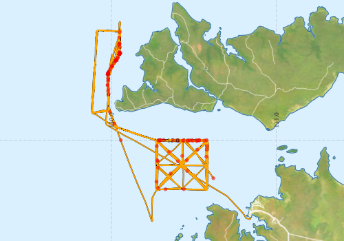
Voyage extents: 12° 29.3' S to 11° 17.0' S 129° 52.8' E to 130° 50.8' E Get voyage track shapefile Get CSV
Marlin Metadata:-
Participants - on ship:-
| Name | Role | Organisation |
|---|---|---|
| Bob Griffiths | CSIRO Marmion | |
| Brian Sanderson | Chief Investigator | Bureau of Meteorology |
| Dave Edwards | Cruise Manager | CSIRO ORV |
| Frank Bradley | CSIRO Centre for Environmental Mechanics | |
| Gary Miller | CSIRO Centre for Environmental Mechanics | |
| Ian Helmond | CSIRO ORV | |
| Lindsay Pender | CSIRO ORV | |
| Marion Tait | Flinders University | |
| Michael Whimpey | Bureau of Meteorology |
This list includes those that may have only been on part of the voyage. See voyage reports on 'Reports and Maps' tab for details.
Marine National Facility Reports - plans, summaries and data processing
-
FR199509 Voyage Summary
- includes preliminary results, voyage narrative, types of data collected with C77/ROSCOP codes.
-
FR199509 Voyage Plan
- includes objectives, investigator details, proposed data collection, voyage track and equipment to be used.
-

Search for publications, reports and datasets from this and other voyages
Data publishing
This is a list of online datasets hosted by CSIRO. Other processed datasets hosted by collaborating organisations may be found on the 'Metadata' or "Reports, Publications and Maps' tab.
Use the Get data link on the right to extract data using the NCMI Data Trawler.
| Data Stream | Data Summary | Get data | ||||||||||||||
|---|---|---|---|---|---|---|---|---|---|---|---|---|---|---|---|---|
| ADCP Data |
|
Get Data from Trawler Download ASCII dataset - fr9509adcp.zip Download NetCDF dataset - fr9509adcpCDF.zip Download Processing Report - fr9509adcp.pdf |
||||||||||||||
| CTD profile |
|
Get Data from Trawler |
||||||||||||||
| Hydrology |
|
Get Data from Trawler |
||||||||||||||
| Towed CTD |
|
Get Data from Trawler Download FR199509 Seasoar data |
||||||||||||||
| Underway |
|
Get Data from Trawler |
||||||||||||||
| XBT Profile |
Deployments by start time:- Click on column header to sort. Use link on 'Deployment' to see full details. Use the CSV button at the bottom to export data (tab delimited).
Search for deployments from this voyage and others
| Deployment | Operation | Station | Cast | Gear | Project | Start and end times | Start Location | End Location | Depth range | Max Depth | Description | |||
|---|---|---|---|---|---|---|---|---|---|---|---|---|---|---|
| Underway System [details] | Anemometer,Anemometer,Anemometer,Barometer,Gyro-MK 10,Humidity probe,Licor-UWQ 4653,RIMCO vane driving potentiometer,RIMCO vane driving potentiometer,Ships log,Simrad EA500 Echosounder,Temperature sensor-AD590J,ThermoSalinoGraph (TSG),ThermoSalinoGraph (TSG) | 106 | 1995-11-21 02:00 | 1995-12-06 02:00 | -12.2295 | 130.6190 | -12.4720 | 130.8470 | ||||||
| CTD Cast / Hydrology [details] | 1 | Cast 1 | 106 | 1995-11-21 06:34 | 1995-11-21 07:00 | -12.0010 | 130.2860 | -12.0003 | 130.2972 | 0 | ||||
| CTD Cast / Hydrology [details] | 1 | Cast 2 | 106 | 1995-11-21 08:03 | 1995-11-21 08:21 | -12.0015 | 130.4340 | -12.0000 | 130.4392 | 0 | ||||
| CTD Cast / Hydrology [details] | 1 | Cast 3 | 106 | 1995-11-21 09:23 | 1995-11-21 09:28 | -11.9987 | 130.5773 | -11.9977 | 130.5765 | 0 | ||||
| XBT Cast [details] | 106 | 1995-11-21 10:57 | -12.0992 | 130.5757 | 30 | |||||||||
| XBT Cast [details] | 106 | 1995-11-22 00:40 | -11.9988 | 130.0575 | 55 | |||||||||
| Towed CTD [details] | SeaSoar | 106 | 1995-11-22 07:18 | 1995-11-22 07:35 | -12.1647 | 130.2827 | -12.1352 | 130.2823 | 22.8 | Leg: fr0995002 | ||||
| Towed CTD [details] | SeaSoar | 106 | 1995-11-22 07:40 | 1995-11-22 08:06 | -12.1260 | 130.2818 | -12.0712 | 130.2763 | 21 | Leg: fr0995003 | ||||
| Towed CTD [details] | SeaSoar | 106 | 1995-11-22 08:29 | 1995-11-22 08:48 | -12.0348 | 130.2752 | -11.9985 | 130.2778 | 22.9 | Leg: fr0995004 | ||||
| Towed CTD [details] | SeaSoar | 106 | 1995-11-22 09:57 | 1995-11-22 10:23 | -12.0003 | 130.4082 | -12.0008 | 130.4575 | 24.3 | Leg: fr0995005 | ||||
| Towed CTD [details] | SeaSoar | 106 | 1995-11-22 10:26 | 1995-11-22 10:59 | -12.0010 | 130.4628 | -12.0012 | 130.5238 | 20.2 | Leg: fr0995006 | ||||
| Towed CTD [details] | SeaSoar | 106 | 1995-11-22 11:01 | 1995-11-22 11:29 | -12.0012 | 130.5273 | -12.0008 | 130.5773 | 15.8 | Leg: fr0995007 | ||||
| Towed CTD [details] | SeaSoar | 106 | 1995-11-23 00:12 | 1995-11-23 00:46 | -12.2893 | 130.2833 | -12.2963 | 130.3197 | 16.7 | Leg: fr0995009 | ||||
| Towed CTD [details] | SeaSoar | 106 | 1995-11-23 00:52 | 1995-11-23 01:22 | -12.2962 | 130.3280 | -12.2945 | 130.3787 | 16.3 | Leg: fr0995010 | ||||
| Towed CTD [details] | SeaSoar | 106 | 1995-11-23 01:58 | 1995-11-23 06:19 | -12.2953 | 130.4387 | -12.0695 | 130.3513 | 29.7 | Leg: fr0995011 | ||||
| Towed CTD [details] | SeaSoar | 106 | 1995-11-23 06:20 | 1995-11-23 08:32 | -12.0695 | 130.3512 | -11.9998 | 130.4383 | 31.1 | Leg: fr0995012 | ||||
| Towed CTD [details] | SeaSoar | 106 | 1995-11-23 09:11 | 1995-11-23 12:09 | -11.9993 | 130.5157 | -12.2997 | 130.5785 | 21.9 | Leg: fr0995013 | ||||
| Towed CTD [details] | SeaSoar | 106 | 1995-11-24 01:10 | 1995-11-24 01:50 | -12.1267 | 130.4035 | -12.1740 | 130.4492 | 20.8 | Leg: fr0995015 | ||||
| Towed CTD [details] | SeaSoar | 106 | 1995-11-24 01:59 | 1995-11-24 03:39 | -12.1857 | 130.4593 | -12.2852 | 130.5813 | 17.1 | Leg: fr0995016 | ||||
| Towed CTD [details] | SeaSoar | 106 | 1995-11-24 06:06 | 1995-11-24 07:55 | -12.0020 | 130.5632 | 16.9 | Leg: fr0995017 | ||||||
| XBT Cast [details] | 106 | 1995-11-24 09:21 | -12.0003 | 130.2908 | 40 | |||||||||
| XBT Cast [details] | 106 | 1995-11-24 11:46 | -12.0355 | 130.5805 | 30 | |||||||||
| Towed CTD [details] | SeaSoar | 106 | 1995-11-25 00:28 | 1995-11-25 01:31 | -12.0940 | 130.4298 | -12.0003 | 130.4557 | 20.8 | Leg: fr0995019 | ||||
| Towed CTD [details] | SeaSoar | 106 | 1995-11-25 01:44 | 1995-11-25 03:20 | -12.0003 | 130.4757 | -12.0540 | 130.5232 | 18.7 | Leg: fr0995020 | ||||
| Towed CTD [details] | SeaSoar | 106 | 1995-11-25 03:21 | 1995-11-25 03:51 | -12.0567 | 130.5205 | -12.1078 | 130.4693 | 14.1 | Leg: fr0995021 | ||||
| Towed CTD [details] | SeaSoar | 106 | 1995-11-25 03:58 | 1995-11-25 05:57 | -12.1200 | 130.4583 | -12.2883 | 130.2740 | 20.8 | Leg: fr0995022 | ||||
| Towed CTD [details] | SeaSoar | 106 | 1995-11-25 06:17 | 1995-11-25 07:23 | -12.2503 | 130.2740 | -12.1230 | 130.2778 | 19.7 | Leg: fr0995023 | ||||
| Towed CTD [details] | SeaSoar | 106 | 1995-11-25 07:24 | 1995-11-25 08:19 | -12.1208 | 130.2780 | -12.0188 | 130.2803 | 20 | Leg: fr0995025 | ||||
| Towed CTD [details] | SeaSoar | 106 | 1995-11-25 09:09 | 1995-11-25 09:42 | -12.0005 | 130.3955 | -11.9993 | 130.4850 | 18 | Leg: fr0995028 | ||||
| Towed CTD [details] | SeaSoar | 106 | 1995-11-25 09:44 | 1995-11-25 10:26 | -11.9993 | 130.4893 | -12.0138 | 130.5835 | 12.7 | Leg: fr0995029 | ||||
| Towed CTD [details] | SeaSoar | 106 | 1995-11-26 06:12 | 1995-11-26 07:17 | -11.9983 | 130.2965 | -12.0025 | 130.4655 | 21 | Leg: fr0995031 | ||||
| Towed CTD [details] | SeaSoar | 106 | 1995-11-26 07:17 | 1995-11-26 07:26 | -12.0025 | 130.4657 | -12.0023 | 130.4902 | 13.7 | Leg: fr0995032 | ||||
| Towed CTD [details] | SeaSoar | 106 | 1995-11-26 07:27 | 1995-11-26 09:02 | -12.0025 | 130.4940 | -12.1257 | 130.5807 | 21.8 | Leg: fr0995033 | ||||
| Towed CTD [details] | SeaSoar | 106 | 1995-11-26 23:02 | 1995-11-27 00:57 | -12.0560 | 130.5788 | -11.9988 | 130.3752 | 18.7 | Leg: fr0995036 | ||||
| Towed CTD [details] | SeaSoar | 106 | 1995-11-27 00:57 | 1995-11-27 01:45 | -11.9988 | 130.3738 | -12.0023 | 130.2835 | 18.2 | Leg: fr0995037 | ||||
| Towed CTD [details] | SeaSoar | 106 | 1995-11-27 01:52 | 1995-11-27 03:20 | -11.9995 | 130.2958 | -12.0013 | 130.4368 | 19.7 | Leg: fr0995038 | ||||
| Towed CTD [details] | SeaSoar | 106 | 1995-11-27 03:21 | 1995-11-27 04:19 | -12.0013 | 130.4382 | -11.9985 | 130.5307 | 17.9 | Leg: fr0995039 | ||||
| Towed CTD [details] | SeaSoar | 106 | 1995-11-27 04:20 | 1995-11-27 05:15 | -11.9983 | 130.5322 | -12.0045 | 130.5240 | 13.1 | Leg: fr0995040 | ||||
| Towed CTD [details] | SeaSoar | 106 | 1995-11-27 05:18 | 1995-11-27 07:30 | -12.0045 | 130.5175 | -11.9980 | 130.3135 | 20.1 | Leg: fr0995041 | ||||
| Towed CTD [details] | SeaSoar | 106 | 1995-11-27 07:31 | 1995-11-27 08:50 | -11.9982 | 130.3173 | -12.0002 | 130.5308 | 19.8 | Leg: fr0995042 | ||||
| Towed CTD [details] | SeaSoar | 106 | 1995-11-27 08:51 | 1995-11-27 09:11 | -12.0002 | 130.5342 | -12.0038 | 130.5833 | 13.7 | Leg: fr0995043 | ||||
| ADCP Data [details] | RDI VM-150 Acoustic Doppler current profiler | 106 | 1995-11-27 12:40 | 1995-12-06 00:20 | -12.2010 | 130.3600 | -12.4730 | 130.8460 | 108.4 | |||||
| Towed CTD [details] | SeaSoar | 106 | 1995-11-28 22:41 | 1995-11-29 00:25 | -11.6408 | 129.9805 | -11.8882 | 130.0148 | 19.1 | Leg: fr0995045 | ||||
| Towed CTD [details] | SeaSoar | 106 | 1995-11-29 00:29 | 1995-11-29 03:52 | -11.8987 | 130.0180 | -11.5207 | 130.0223 | 19.6 | Leg: fr0995046 | ||||
| Towed CTD [details] | SeaSoar | 106 | 1995-11-29 03:53 | 1995-11-29 06:52 | -11.5182 | 130.0242 | -11.5498 | 130.0080 | 17.1 | Leg: fr0995047 | ||||
| Towed CTD [details] | SeaSoar | 106 | 1995-11-29 06:53 | 1995-11-29 09:33 | -11.5520 | 130.0067 | -11.5485 | 130.0078 | 19.1 | Leg: fr0995048 | ||||
| Towed CTD [details] | SeaSoar | 106 | 1995-11-30 23:11 | 1995-11-30 23:24 | -11.7007 | 129.9810 | -11.6745 | 129.9790 | 20.2 | Leg: fr0995050 | ||||
| Towed CTD [details] | SeaSoar | 106 | 1995-11-30 23:29 | 1995-12-01 00:13 | -11.6648 | 129.9783 | -11.5827 | 129.9863 | 19.2 | Leg: fr0995051 | ||||
| Towed CTD [details] | SeaSoar | 106 | 1995-12-01 00:15 | 1995-12-01 03:30 | -11.5805 | 129.9875 | -11.3443 | 130.0505 | 19 | Leg: fr0995052 | ||||
| Towed CTD [details] | SeaSoar | 106 | 1995-12-01 03:30 | 1995-12-01 06:17 | -11.3447 | 130.0505 | -11.5197 | 130.0222 | 19.7 | Leg: fr0995053 | ||||
| Towed CTD [details] | SeaSoar | 106 | 1995-12-01 06:18 | 1995-12-01 07:08 | -11.5180 | 130.0233 | -11.4160 | 130.0495 | 18.9 | Leg: fr0995054 | ||||
| Towed CTD [details] | SeaSoar | 106 | 1995-12-01 07:09 | 1995-12-01 08:24 | -11.4137 | 130.0495 | 16.7 | Leg: fr0995055 | ||||||
| Towed CTD [details] | SeaSoar | 106 | 1995-12-01 08:25 | 1995-12-01 10:12 | -11.4162 | 130.0495 | -11.6208 | 129.9800 | 18.9 | Leg: fr0995056 | ||||
| Towed CTD [details] | SeaSoar | 106 | 1995-12-01 10:13 | 1995-12-01 10:42 | -11.6240 | 129.9802 | -11.6875 | 129.9825 | 17.8 | Leg: fr0995057 | ||||
| Towed CTD [details] | SeaSoar | 106 | 1995-12-01 10:42 | 1995-12-01 12:12 | -11.6877 | 129.9825 | -11.8303 | 129.9925 | 18.2 | Leg: fr0995058 | ||||
| Towed CTD [details] | SeaSoar | 106 | 1995-12-01 12:13 | 1995-12-01 14:31 | -11.8283 | 129.9922 | -11.5687 | 129.9950 | 18.2 | Leg: fr0995059 | ||||
| Towed CTD [details] | SeaSoar | 106 | 1995-12-02 03:51 | 1995-12-02 04:52 | -11.4210 | 130.0463 | -11.5475 | 130.0047 | 17 | Leg: fr0995061 | ||||
| Towed CTD [details] | SeaSoar | 106 | 1995-12-02 04:53 | 1995-12-02 06:25 | -11.5463 | 130.0033 | -11.5638 | 129.9960 | 19.2 | Leg: fr0995062 | ||||
| Towed CTD [details] | SeaSoar | 106 | 1995-12-02 06:27 | 1995-12-02 06:28 | -11.5668 | 129.9938 | -11.5692 | 129.9925 | 3.6 | Leg: fr0995063 | ||||
| Towed CTD [details] | SeaSoar | 106 | 1995-12-02 06:40 | 1995-12-02 08:26 | -11.5912 | 129.9808 | -11.4783 | 130.0492 | 18.9 | Leg: fr0995064 | ||||
| Towed CTD [details] | SeaSoar | 106 | 1995-12-02 08:27 | 1995-12-02 10:43 | -11.4767 | 130.0500 | -11.4678 | 130.0498 | 16.6 | Leg: fr0995065 | ||||
| Towed CTD [details] | SeaSoar | 106 | 1995-12-02 10:44 | 1995-12-02 11:49 | -11.4705 | 130.0500 | -11.5903 | 129.9817 | 18 | Leg: fr0995066 | ||||
| XBT Cast [details] | 106 | 1995-12-02 12:36 | -11.5303 | 130.0185 | 30 | |||||||||
| XBT Cast [details] | 106 | 1995-12-02 13:15 | -11.4777 | 130.0502 | 25 | |||||||||
| Towed CTD [details] | SeaSoar | 106 | 1995-12-03 00:07 | 1995-12-03 01:04 | -11.7197 | 129.9837 | -11.6030 | 129.9792 | 18.8 | Leg: fr0995068 | ||||
| Towed CTD [details] | SeaSoar | 106 | 1995-12-03 01:05 | 1995-12-03 02:22 | -11.6008 | 129.9793 | -11.4763 | 130.0502 | 19.9 | Leg: fr0995069 | ||||
| XBT Cast [details] | 106 | 1995-12-03 01:33 | -11.5542 | 130.0027 | 40 | |||||||||
| XBT Cast [details] | 106 | 1995-12-03 02:22 | -11.4765 | 130.0502 | 25 | |||||||||
| Towed CTD [details] | SeaSoar | 106 | 1995-12-03 02:23 | 1995-12-03 04:56 | -11.4740 | 130.0500 | -11.4943 | 130.0430 | 16.7 | Leg: fr0995070 | ||||
| Towed CTD [details] | SeaSoar | 106 | 1995-12-03 04:59 | 1995-12-03 05:43 | -11.5017 | 130.0392 | -11.6000 | 129.9785 | 20.1 | Leg: fr0995071 | ||||
| Towed CTD [details] | SeaSoar | 106 | 1995-12-03 05:44 | 1995-12-03 07:04 | -11.6018 | 129.9767 | -11.4733 | 130.0523 | 19.9 | Leg: fr0995072 | ||||
| Towed CTD [details] | SeaSoar | 106 | 1995-12-03 07:07 | 1995-12-03 09:19 | -11.4715 | 130.0558 | -11.4813 | 130.0477 | 19.9 | Leg: fr0995073 | ||||
| Towed CTD [details] | SeaSoar | 106 | 1995-12-03 09:20 | 1995-12-03 13:03 | -11.4785 | 130.0497 | -11.6030 | 129.9807 | 20.7 | Leg: fr0995074 | ||||
| XBT Cast [details] | 106 | 1995-12-03 09:26 | -11.4653 | 130.0495 | 25 | |||||||||
| XBT Cast [details] | 106 | 1995-12-03 11:41 | -11.5998 | 129.9812 | 30 | |||||||||
| Towed CTD [details] | SeaSoar | 106 | 1995-12-03 13:04 | 1995-12-03 13:50 | -11.6003 | 129.9808 | -11.5170 | 130.0295 | 20.8 | Leg: fr0995075 | ||||
| Towed CTD [details] | SeaSoar | 106 | 1995-12-03 13:51 | 1995-12-03 15:38 | -11.5142 | 130.0313 | 15.9 | Leg: fr0995076 | ||||||
| XBT Cast [details] | 106 | 1995-12-03 14:16 | -11.4695 | 130.0498 | 25 | |||||||||
| Towed CTD [details] | SeaSoar | 106 | 1995-12-03 15:39 | 1995-12-03 17:10 | -11.5172 | 130.0285 | -11.6682 | 129.9773 | 20 | Leg: fr0995077 | ||||
| XBT Cast [details] | 106 | 1995-12-03 16:18 | -11.5938 | 129.9813 | 30 | |||||||||
| Towed CTD [details] | SeaSoar | 106 | 1995-12-03 17:11 | 1995-12-03 18:30 | -11.6657 | 129.9775 | -11.5148 | 130.0267 | 20.7 | Leg: fr0995078 | ||||
| Towed CTD [details] | SeaSoar | 106 | 1995-12-03 18:32 | 1995-12-03 19:38 | -11.5108 | 130.0288 | -11.4318 | 130.0532 | 16.9 | Leg: fr0995079 | ||||
| XBT Cast [details] | 106 | 1995-12-03 18:51 | -11.4763 | 130.0495 | 25 | |||||||||
| Towed CTD [details] | SeaSoar | 106 | 1995-12-03 19:40 | 1995-12-03 20:12 | -11.4358 | 130.0525 | -11.4952 | 130.0407 | 18.9 | Leg: fr0995080 | ||||
| Towed CTD [details] | SeaSoar | 106 | 1995-12-03 20:14 | 1995-12-03 21:35 | -11.4980 | 130.0383 | -11.6307 | 129.9822 | 20.1 | Leg: fr0995081 | ||||
| XBT Cast [details] | 106 | 1995-12-03 21:12 | -11.5910 | 129.9818 | 30 | |||||||||
| Towed CTD [details] | SeaSoar | 106 | 1995-12-03 21:37 | 1995-12-03 23:01 | -11.6335 | 129.9822 | -11.5562 | 129.9993 | 20 | Leg: fr0995082 | ||||
| XBT Cast [details] | 106 | 1995-12-04 00:27 | -11.3780 | 130.0485 | 25 | |||||||||
| XBT Cast [details] | 106 | 1995-12-04 02:45 | -11.5918 | 129.9817 | 30 | |||||||||
| XBT Cast [details] | 106 | 1995-12-05 03:56 | -11.5153 | 130.0335 | 30 | |||||||||