Please login if you have access to particular applications.
Catch Data - from CSIRO surveys.
| CAAB Code: | 37 441003 [taxon report] |
| Scientific Name and Authority: | Katsuwonus pelamis (Linnaeus, 1758) |
| CAAB category: | 37 - Pisces |
| Standard Name (AS 5300): | Skipjack Tuna |
Distribution map:
View detailed map or click on map to see same.
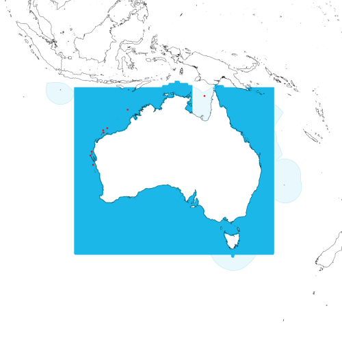
Modelled distribution shown as blue polygon (source: Australian National Fish Expert Distributions) Updated on 2009-01-06.
Occurrence locations [8] shown as red circles - View CSIRO Catch records Get expert distribution shapefile
View detailed map or click on map to see same.
Modelled distribution shown as blue polygon (source: Australian National Fish Expert Distributions) Updated on 2009-01-06.
Occurrence locations [8] shown as red circles - View CSIRO Catch records Get expert distribution shapefile
Catch records - 8 records found.
Click on survey to see survey details. Click on Operation to see full details of the catch. Use the CSV button at the bottom to export data.
| Date (UTC) | Position | Survey | Operation | Depth Range (m) | Count | Weight (kg) | Method | Effort | Gear |
|---|---|---|---|---|---|---|---|---|---|
| 1966-09-02 00:00 | 24° 31.0' S 113° 05.0' E | RADU196608 | 15 | 60 to 60 | 1 | Trawl | 60 minutes | ||
| 1970-03-29 00:00 | 11° 56.1' S 140° 00.0' E | PROM197002 | 75 | 57 to 58 | 1 | Trawl | 60 minutes | ||
| 1973-05-11 00:00 | 27° 21.0' S 113° 25.0' E | LIRA197304 | 38 | 80 to 93 | 1 | Trawl | 90 minutes | ||
| 1973-10-27 00:00 | 25° 22.1' S 112° 46.0' E | ALBA197310 | 430 | 97 to 100 | 2 | 3 | Trawl | 60 minutes | |
| 1974-10-25 00:00 | 19° 20.0' S 116° 48.1' E | SHAN197405 | 179 | 118 to 122 | 1 | 1.5 | Trawl | 65 minutes | |
| 1974-10-28 00:00 | 20° 20.0' S 115° 55.1' E | SHAN197405 | 197 | 41 to 42 | 15 | 15 | Trawl | 60 minutes | |
| 1974-10-28 00:00 | 19° 49.1' S 115° 50.1' E | SHAN197405 | 200 | 104 to 120 | 8 | 8 | Trawl | 60 minutes | |
| 1978-06-27 15:40 | 15° 07.0' S 121° 40.0' E | COUR197836 | 15 | 204 to 210 | Stern Trawl | 100 minutes |