Please login if you have access to particular applications.
Catch Data - from CSIRO surveys.
| CAAB Code: | 37 031031 [taxon report] |
| Scientific Name and Authority: | Dentiraja oculus (Last, 2008) |
| CAAB category: | 37 - Pisces |
| Standard Name: | Ocellate Skate |
Distribution map:
View detailed map or click on map to see same.
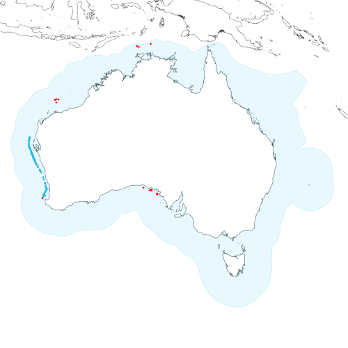
Modelled distribution shown as blue polygon (source: Australian National Fish Expert Distributions) Updated on 2008-11-19.
Occurrence locations [19] shown as red circles - View CSIRO Catch records Get expert distribution shapefile
View detailed map or click on map to see same.
Modelled distribution shown as blue polygon (source: Australian National Fish Expert Distributions) Updated on 2008-11-19.
Occurrence locations [19] shown as red circles - View CSIRO Catch records Get expert distribution shapefile
Catch records - 19 records found.
Click on survey to see survey details. Click on Operation to see full details of the catch. Use the CSV button at the bottom to export data.
| Date (UTC) | Position | Survey | Operation | Depth Range (m) | Count | Weight (kg) | Method | Effort | Gear |
|---|---|---|---|---|---|---|---|---|---|
| 1967-07-09 00:00 | 10° 01.1' S 130° 18.0' E | BERG196705 | 324 | 142 to 152 | 4 | Trawl | 60 minutes | ||
| 1967-07-10 00:00 | 10° 10.1' S 130° 37.0' E | BERG196705 | 325 | 100 to 110 | 1 | Trawl | 60 minutes | ||
| 1967-07-11 00:00 | 9° 39.0' S 132° 37.1' E | BERG196705 | 332 | 127 to 129 | 1 | Trawl | 60 minutes | ||
| 1970-09-13 00:00 | 32° 19.1' S 132° 26.1' E | ALBA197009 | 622 | 59 to 62 | 4 | Trawl | 60 minutes | ||
| 1970-09-13 00:00 | 32° 20.1' S 132° 45.1' E | ALBA197009 | 621 | 60 to 62 | 3 | Trawl | 60 minutes | ||
| 1970-09-14 00:00 | 31° 56.0' S 131° 23.0' E | ALBA197009 | 626 | 52 to 54 | 1 | Trawl | 60 minutes | ||
| 1971-09-10 00:00 | 19° 08.0' S 116° 50.1' E | EQUA197109 | 1 | 185 to 235 | 1 | Trawl | 60 minutes | ||
| 1972-08-25 00:00 | 32° 48.0' S 133° 41.1' E | RADU197206 | 136 | 58 to 60 | 1 | Trawl | 60 minutes | ||
| 1972-08-26 00:00 | 32° 47.0' S 133° 40.1' E | RADU197206 | 139 | 60 to 62 | 2 | Trawl | 60 minutes | ||
| 1972-08-26 00:00 | 32° 54.1' S 133° 44.0' E | RADU197206 | 140 | 55 to 62 | 1 | 70 | Trawl | 120 minutes | |
| 1972-08-27 00:00 | 32° 47.1' S 133° 37.0' E | RADU197206 | 142 | 60 to 60 | 1 | Trawl | 65 minutes | ||
| 1972-08-30 00:00 | 32° 13.0' S 132° 41.1' E | RADU197206 | 157 | 60 to 60 | 1 | 40 | Trawl | 60 minutes | |
| 1972-08-31 00:00 | 32° 15.0' S 132° 46.0' E | RADU197206 | 161 | 55 to 56 | 1 | 20 | Trawl | 60 minutes | |
| 1972-09-21 00:00 | 32° 46.1' S 133° 43.0' E | RADU197206 | 238 | 55 to 55 | 1 | 70 | Trawl | 60 minutes | |
| 1982-04-06 09:10 | 18° 40.0' S 116° 43.0' E | SO198202 | 28 | 2 | 0.1 | Stern Trawl | 50 minutes | ||
| 1982-04-06 21:55 | 18° 43.0' S 116° 35.0' E | SO198202 | 29 | 1 | 0.13 | Stern Trawl | 50 minutes | ||
| 1982-04-07 02:00 | 18° 38.0' S 116° 52.0' E | SO198202 | 30 | 2 | 0.13 | Stern Trawl | 50 minutes | ||
| 1982-04-13 00:25 | 18° 40.0' S 117° 13.0' E | SO198202 | 43 | 2 | 0.24 | Stern Trawl | 50 minutes | ||
| 1991-02-16 08:20 | 33° 24.1' S 114° 31.4' E | SS199101 | 88 | 203 to 204 | 2 | 2.25 | Trawl | 30 minutes |