Voyage details and related metadata, reports, events and data.
SS2013_V01
- is a Marine National Facility ![]() voyage
voyage
Period: 2013-01-17 22:00 to 2013-02-04 03:00 UTC
Duration: 17.21 days
From: Brisbane To: Brisbane
Region: Continental slope northern New South Wales and southern Queensland
Ship: Southern Surveyor [details]
Description: Southern Surveyor SS2013_V01. Submarine landslides offshore northern New South Wales and southern Queensland: their geomechanical characteristics, timing and triggers. Scientific Objectives: An extensive region of the continental slope located offshore Northern NSW and Southern Queensland between Byron Bay and the southern tip of Fraser was demonstrated to have experienced intense submarine erosion dominated by submarine landsliding in 2008 (SS 12/2008, Boyd, Keene, Gardner, Exon, Hubble et al). Major questions about the geographic extent of the area affected by these processes, the geomechanics and dynamics of sliding; the timing and frequency of sliding; and the potential trigger mechanism for slide initiation have arisen from the analysis of the material collected by the scientists who participated in the SS12/2008 voyage. These workers and their colleagues (Hubble, Airey, Clarke, Yu, Keene, Boyd et al) demonstrated that submarine landsliding on Eastern Australia's continental margin is unexpectedly young and frequent at geological timescales. They have also developed geological and geotechnical models which attempt to explain the apparent youth and unexpected frequency of submarine landsliding in this area of the eastern Australian continental margin. This project will extend the findings of the SS 12/2008 work by collecting data that will help to validate or modify the models developed to explain the areas submarine erosion and landsliding. This will be achieved by collecting additional core and dredge samples in the original study area and by extending the coverage of detailed bathymetric to the north of the 2008 study area; and by sampling appropriate features in the area identified in the area where this new bathymetric mapping of the outer shelf and slope will be undertaken.
Leader: T. Hubble (USYD)
Project: National Facility External Users: T. Hubble (USYD) [details]
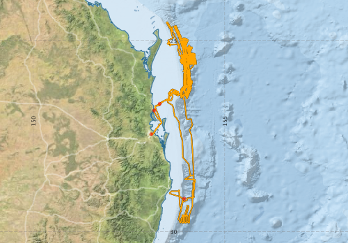
Voyage extents: 29° 46.3' S to 24° 30.6' S 153° 04.7' E to 154° 15.3' E Get voyage track shapefile Get CSV
Marlin Metadata:-
Participants - on ship:-
| Name | Role | Organisation |
|---|---|---|
| Angel Puga Bernabeu | Marine Geologist | University of Granada |
| David Airey | Principle Investigator | University of Sydney |
| David Mitchell | Marine Technician | University of Sydney |
| David Voelker | Marine Geologist | GEOMAR, Kiel |
| James Daniell | Multibeam Expert / Marine Geologist | James Cook University |
| Jody Webster | Co-Chief Scientist | University of Sydney |
| Melissa Fletcher | Msc | University of Sydney |
| Phyllis Yu | PhD Student | University of Sydney |
| Samantha Clarke | PhD Student | University of Sydney |
| Tom Hubble | Chief Scientist | University of Sydney |
This list includes those that may have only been on part of the voyage. See voyage reports on 'Reports and Maps' tab for details.
Marine National Facility Reports - plans, summaries and data processing
-
SS2013_V01 Voyage Plan
- includes objectives, investigator details, proposed data collection, voyage track and equipment to be used.
-
SS2013_V01 Underway Data Processing Report
- details of data processing steps, calibration information, instruments used and any issues with the data.
-
SS2013_V01 Voyage Summary
- includes preliminary results, voyage narrative, types of data collected with C77/ROSCOP codes.
-
SS2013_V01 Scientific Highlight
- report of the key outputs
-

Publications, reports and datasets from this voyage.
Book Chapter
- Hubble, T., Webster, J., Yu, P., Fletcher, M., Voelker, D., Airey, D., Clarke, S., Puga-Bernabeu, A., Mitchell, D., Howard, F., Gallagher, S. & Martin, T. (2016) Submarine Landslides and Incised Canyons of the Southeast Queensland Continental Margin. In Submarine Mass Movements and their Consequences: 7th International Symposium. Cham: Springer International Publishing. External link to reference
- Mollison, Kendall C.,Power, Hannah E.,Clarke, Samantha L.,Baxter, Alan T.,Lane, Emily M.,Hubble, Thomas C. T. (2020) The sedimentology and tsunamigenic potential of the Byron submarine landslide off New South Wales, Australia. Geological Society, London, Special Publications 500 pp27-40. 10.1144/SP500-2019-160
Conference Poster
- Clarke, S., Hubble, T., Airey, D. & Ward, S. (2015), Eastern Australia's submarine landslides: implications for tsunami hazard between Jervis Bay and Fraser Island, Landslides.
External link to reference
Conference abstract
- Hubble T.C.T., Yu P., Clarke S., Airey D.W., Webster J.M., Völker D., Puga-Bernabéu, Á., Fletcher M., Howard, F., Kinsela, M., Mitchell D., Shipboard Party SS2013-V01 (2013). Probable Landslide Detachment Surfaces and Post-slide Deposits Sampled From The Yamba Slide Complex, New South Wales, Australia. 6th International Symposium on Submarine Mass Movements and Their Consequences, Kiel, Germany.
- Hubble, T., Yu, P., Clarke, S., Airey, D., Webster, J., & Voelker, D. (2013), Probable Landslide Detachment Surfaces And Post-slide Deposits Sampled From The Yamba Slide Complex, New South Wales, Australia. Abstract #98. 6th International Symposium on Submarine Mass Movements and Their Consequences, Kiel, Germany, Sept, 23-25, 2013. External link to reference
- Hubble, T.C.T., Webster, J.M., Völker, D., Airey, D., Clarke, S., Puga-Bernabéu, Á., Kinsela, M., Yu, P., Fletcher, M., Mitchell, D., Howard, F., Shipboard Party SS2013-V01 (2016). The submarine landslides and incised canyons of the South-East Queensland Continental Margin: their physical characteristics and sedimentology. 7th International Symposium on Submarine Mass Movements and Their Consequences, Wellington, New Zealand, volume 41, 125-133
- Völker, D., Hubble, T., Clarke, S., Webster, J.M., Puga-Bernabéu, Á. (2013), Mapping the South Queensland margin: collapses, depressions and general instability. 6th International Symposium on Submarine Mass Movements and Their Consequences, Kiel, Germany. External link to reference
Dataset
- Bakker, Dorothee C E; Pfeil, Benjamin; Smith, Karl; Hankin, Steven; Olsen, Are; Alin, Simone R; Cosca, Catherine E; Harasawa, Sumiko; Kozyr, Alexander; Nojiri, Yukihiro; O'Brien, Kevin M; Schuster, Ute; Telszewski, Maciej; Tilbrook, Bronte; Wada, Chisato; Akl, John; Barbero, Leticia; Bates, Nicolas R; Boutin, Jacqueline; Bozec, Yann; Cai, Wei-Jun; Castle, Robert D; Chavez, Francisco P; Chen, Lei; Chierici, Melissa; Currie, Kim I; de Baar, Hein J W; Evans, Wiley; Feely, Richard A; Fransson, Agneta; Gao, Zhongyong; Hales, Burke; Hardman-Mountford, Nicolas J; Hoppema, Mario; Huang, Wei-Jen; Hunt, Christopher W; Huss, Betty; Ichikawa, Tadafumi; Johannessen, Truls; Jones, Elizabeth M; Jones, Steve D; Jutterstrøm, Sara; Kitidis, Vassilis; Körtzinger, Arne; Landschützer, Peter; Lauvset, Siv K; Lefèvre, Nathalie; Manke, Ansley; Mathis, Jeremy T; Merlivat, Liliane; Metzl, Nicolas; Murata, Akihiko; Newberger, Timothy; Omar, Abdirahman M; Ono, Tsuneo; Park, Geun-Ha; Paterson, Kristina; Pierrot, Denis; Ríos, Aida F; Sabine, Christopher L; Saito, Shu; Salisbury, Joe; Sarma, Vedula V S S; Schlitzer, Reiner; Sieger, Rainer; Skjelvan, Ingunn; Steinhoff, Tobias; Sullivan, Kevin; Sun, Heng; Sutton, Adrienne; Suzuki, Toru; Sweeney, Colm; Takahashi, Taro; Tjiputra, Jerry; Tsurushima, Nobuo; van Heuven, Steven; Vandemark, Doug; Vlahos, Penny; Wallace, Douglas WR; Wanninkhof, Rik; Watson, Andrew J (2014): Surface Ocean CO2 Atlas (SOCAT) V2. PANGAEA, 10.1594/PANGAEA.811776
- Smith, S. R.,Lopez, N.,Bourassa, M. A. (2016) SAMOS air‐sea fluxes: 2005–2014. Geoscience Data Journal 3 pp9-19. 10.1002/gdj3.34
Journal Article
- Clarke, Samantha L.,Hubble, Thomas C. T.,Miao, G.,Airey, D. W.,Ward, S. N. (2019) Eastern Australia’s submarine landslides: implications for tsunami hazard between Jervis Bay and Fraser Island. Landslides 16 pp2059-2085. 10.1007/s10346-019-01223-6
- Hubble T. et al. (2016) Submarine Landslides and Incised Canyons of the Southeast Queensland Continental Margin. In: Lamarche G. et al. (eds) Submarine Mass Movements and their Consequences. Advances in Natural and Technological Hazards Research, vol 41. Springer, Cham 10.1007/978-3-319-20979-1_12
- Hubble, Thomas,Yeung, Serena,Clarke, Samantha,Baxter, Alan,De Blasio, Fabio (2018) Submarine landslides offshore Yamba, NSW, Australia: an analysis of their timing, downslope motion and possible causes. Geological Society, London, Special Publications ppSP477.11-. 10.1144/SP477.11
- Mollison, Kendall C.,Power, Hannah E.,Clarke, Samantha L.,Baxter, Alan T.,Hubble, Thomas C.T. (2020) Sedimentology, structure, and age of the Wide Bay Canyon submarine landslide on the southeast Australian continental slope. Marine Geology 419 pp106063-. 10.1016/j.margeo.2019.106063
Report
- Kinsela, Michael A.,Hubble, Thomas C.T.,Webster, Jody M.,Clarke, Samantha,Passos, Tiago U.,Airey, David W.,Mitchell, David (2020) Floating High Over Beaches and Dunes Without Wing, Chute or Rotor. Journal of Coastal Research 101 pp351-. 10.2112/JCR-SI101-063.1
Search for publications, reports and datasets from this and other voyages
Data publishing
This is a list of online datasets hosted by CSIRO. Other processed datasets hosted by collaborating organisations may be found on the 'Metadata' or "Reports, Publications and Maps' tab.
Use the Get data link on the right to extract data using the NCMI Data Trawler.
| Data Stream | Data Summary | Get data | ||||||||||||||
|---|---|---|---|---|---|---|---|---|---|---|---|---|---|---|---|---|
| ADCP Data |
|
Get Data from Trawler Download NetCDF ss2013_v01_ADCP_nc.zip Overview ADCP Dataset HTML Download Processing Report ss2013_v01ADCP.pdf |
||||||||||||||
| CTD profile |
|
Get Data from Trawler Download NetCDF data ss2013_v01_CTD_AvgUncalibrated_nc.zip Download Processing report ss2013_v01ctdReport.pdf Download CTD plots ss2013_v01_CTD_plots_png.zip |
||||||||||||||
| Multibeam echosounder |
|
Get Data from Trawler |
||||||||||||||
| Underway |
|
Get Data from Trawler Download 5 sec NetCDF dataset ss2013_v01UWYnc.zip |
Deployments by start time:- Click on column header to sort. Use link on 'Deployment' to see full details. Use the CSV button at the bottom to export data (tab delimited).
Search for deployments from this voyage and others
| Deployment | Operation | Station | Cast | Gear | Project | Start and end times | Start Location | End Location | Depth range | Max Depth | Description | |||
|---|---|---|---|---|---|---|---|---|---|---|---|---|---|---|
| Underway System [details] | Air Temperature Sensor-HMT333,Barometer,Doppler speed log,Fluorometer WS3S-443P,Gill Ultrasonic Wind Sensor,Gill Ultrasonic Wind Sensor,Humidity Sensor-HMT333,IMOS Port Pyranometer-SN 35122F3,IMOS Port Radiometer-SN 35111F3,IMOS Stbd Pyranometer-SN 35123F3,IMOS Stbd Radiometer-SN 35093F3,IMOS rain gauge,IMOS rain gauge,Licor - LI-190SL Q46072,RM Young 05106 wind monitor-75621,RM Young 05106 wind monitor-75621,RM Young 05106 wind monitor-75621,RM Young Rain Gauge,Remote Temperature (T)-SN 2621,Seapath 200,Seapath 200,Seapath 200,Simrad EK60 echosounder,ThermoSalinoGraph (TSG)-SS-SN 1777 | 2409 | 2013-01-17 22:04 | 2013-02-04 02:33 | -27.4469 | 153.0783 | ||||||||
| ADCP Data [details] | RDI Ocean Surveyor Acoustic Doppler current profiler | 2409 | 2013-01-18 03:56 | 2013-02-03 13:04 | -26.8235 | 153.1549 | -26.3736 | 153.7976 | 653.5 | |||||
| Multibeam echosounder [details] | EM300 Multibeam Echosounder | 2013-01-18 05:37 | 2013-02-03 19:58 | -26.6498 | 153.2991 | -26.7056 | 153.1762 | 4468.6 | ||||||
| CTD Cast [details] | 1 | Cast 1 | CTD 21,Conductivity CTD 21 - SN 3309,Oxygen-CTD 21-SBE 43-SN 1239,Pressure CTD 21,Temperature CTD 21 - SN 5422 | 2409 | 2013-01-31 22:52 | 2013-02-01 00:25 | -29.1357 | 153.9391 | -29.1651 | 153.9449 | 1920 | |||