Voyage details and related metadata, reports, events and data.
SS2013_T04
- is a Marine National Facility ![]() voyage
voyage
Period: 2013-09-21 22:00 to 2013-10-02 23:00 UTC
Duration: 11.04 days
From: Brisbane To: Hobart
Region: East coast of Australia
Ship: Southern Surveyor [details]
Description: MNF Southern Surveyor research voyage SS2013_t04. Use the EM300 to search and survey HMAS Australia and HMAS Voyager. Scientific Objective: This work forms part of a wider study to investigate the site formation processes of deepwater shipwrecks. The debris field of the HMAS Australia wreck has never been adequately explored. This work will explore the extent of the debris field from the wreck, including the location of loose guns (rifled cannons) and funnels which were stored on deck, along with the location of the gun turrets which would have fallen out of their mounts during the sinking. These surveys will be the deepest survey of a wreck in NSW water and will provide baseline data for future potential research projects at the University of Sydney and internationally. When used in conjunction with other deepwater Australian shipwreck inspections (eg HMAS Sydney/ Kormoran and Centaur), the proposed survey will contribute further to the understanding of the site formation processes (ie how shipwreck sites form and deteriorate) and the physical decomposition processes of deep water wrecks. Scientific Objectives: The project aims to improve our understanding of the sources, sinks and background concentrations of key greenhouse gases in the Southern Hemisphere. a) Make continuous measurements of carbon dioxide, methane, nitrous oxide, carbon monoxide and ozone as the RV Southern Surveyor travels along the chosen transect; b) Assimilate measured data into a variety of atmospheric chemical transport, inverse and statistical models to improve our knowledge and understanding of atmospheric greenhouse gases and their sources and sinks.
Leader: B Duncan (Office of Environ and Heritage NSW)
Project: National Facility External Users: B. Duncan (Office of Env and Heritage NSW) [details]
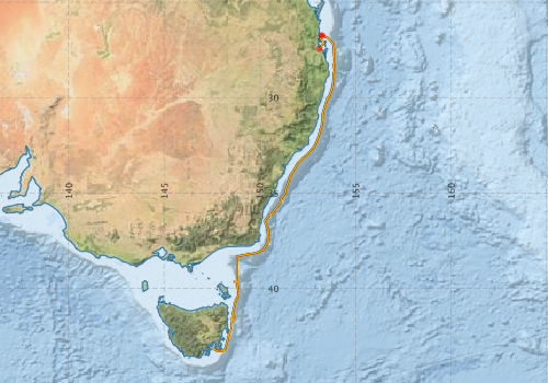
Voyage extents: 43° 17.5' S to 26° 42.4' S 147° 30.6' E to 153° 53.8' E Get voyage track shapefile Get CSV
Marlin Metadata:-
Participants - on ship:-
| Name | Role | Organisation |
|---|---|---|
| Dagmar Kubistin | PI, greenhouse gases | University of Wollongong |
| Jeff Cordell | MNF Electronics Support | CSIRO Marine and Atmospheric Research |
| Pamela Brodie | MNF Computing Support | CSIRO Marine and Atmospheric Research |
| Stuart Edwards | MNF Swath Support | CSIRO Marine and Atmospheric Research |
| Tara Martin | Voyage Manager / MNF Swath Support | CSIRO Marine and Atmospheric Research |
This list includes those that may have only been on part of the voyage. See voyage reports on 'Reports and Maps' tab for details.
Marine National Facility Reports - plans, summaries and data processing
-
SS2013_T04 Underway Data Processing Report
- details of data processing steps, calibration information, instruments used and any issues with the data.
-
SS2013_T04 Voyage Plan
- includes objectives, investigator details, proposed data collection, voyage track and equipment to be used.
-

Publications, reports and datasets from this voyage.
Dataset
- Bakker, Dorothee C E; Pfeil, Benjamin; Smith, Karl; Hankin, Steven; Olsen, Are; Alin, Simone R; Cosca, Catherine E; Harasawa, Sumiko; Kozyr, Alexander; Nojiri, Yukihiro; O'Brien, Kevin M; Schuster, Ute; Telszewski, Maciej; Tilbrook, Bronte; Wada, Chisato; Akl, John; Barbero, Leticia; Bates, Nicolas R; Boutin, Jacqueline; Bozec, Yann; Cai, Wei-Jun; Castle, Robert D; Chavez, Francisco P; Chen, Lei; Chierici, Melissa; Currie, Kim I; de Baar, Hein J W; Evans, Wiley; Feely, Richard A; Fransson, Agneta; Gao, Zhongyong; Hales, Burke; Hardman-Mountford, Nicolas J; Hoppema, Mario; Huang, Wei-Jen; Hunt, Christopher W; Huss, Betty; Ichikawa, Tadafumi; Johannessen, Truls; Jones, Elizabeth M; Jones, Steve D; Jutterstrøm, Sara; Kitidis, Vassilis; Körtzinger, Arne; Landschützer, Peter; Lauvset, Siv K; Lefèvre, Nathalie; Manke, Ansley; Mathis, Jeremy T; Merlivat, Liliane; Metzl, Nicolas; Murata, Akihiko; Newberger, Timothy; Omar, Abdirahman M; Ono, Tsuneo; Park, Geun-Ha; Paterson, Kristina; Pierrot, Denis; Ríos, Aida F; Sabine, Christopher L; Saito, Shu; Salisbury, Joe; Sarma, Vedula V S S; Schlitzer, Reiner; Sieger, Rainer; Skjelvan, Ingunn; Steinhoff, Tobias; Sullivan, Kevin; Sun, Heng; Sutton, Adrienne; Suzuki, Toru; Sweeney, Colm; Takahashi, Taro; Tjiputra, Jerry; Tsurushima, Nobuo; van Heuven, Steven; Vandemark, Doug; Vlahos, Penny; Wallace, Douglas WR; Wanninkhof, Rik; Watson, Andrew J (2014): Surface Ocean CO2 Atlas (SOCAT) V2. PANGAEA, 10.1594/PANGAEA.811776
- Smith, S. R.,Lopez, N.,Bourassa, M. A. (2016) SAMOS air‐sea fluxes: 2005–2014. Geoscience Data Journal 3 pp9-19. 10.1002/gdj3.34
Journal Article
- Bukosa, Beata,Deutscher, Nicholas M.,Fisher, Jenny A.,Kubistin, Dagmar,Paton-Walsh, Clare,Griffith, David W. T. (2019) Simultaneous shipborne measurements of CO2, CH4 and CO and their application to improving greenhouse-gas flux estimates in Australia. Atmospheric Chemistry and Physics 19 pp7055-7072. 10.5194/acp-19-7055-2019
Search for publications, reports and datasets from this and other voyages
Data publishing
This is a list of online datasets hosted by CSIRO. Other processed datasets hosted by collaborating organisations may be found on the 'Metadata' or "Reports, Publications and Maps' tab.
Use the Get data link on the right to extract data using the NCMI Data Trawler.
| Data Stream | Data Summary | Get data | ||||||||||||||
|---|---|---|---|---|---|---|---|---|---|---|---|---|---|---|---|---|
| ADCP Data |
|
Get Data from Trawler Download NetCDF ss2013_t04_ADCP_nc.zip Overview ADCP Dataset HTML Download Processing Report ss2013_t04ADCP.pdf |
||||||||||||||
| Multibeam echosounder |
|
Get Data from Trawler |
||||||||||||||
| Underway |
|
Get Data from Trawler Download 5 sec NetCDF dataset ss2013_t04UWYnc.zip |
Deployments by start time:- Click on column header to sort. Use link on 'Deployment' to see full details. Use the CSV button at the bottom to export data (tab delimited).
Search for deployments from this voyage and others
| Deployment | Operation | Station | Cast | Gear | Project | Start and end times | Start Location | End Location | Depth range | Max Depth | Description | |||
|---|---|---|---|---|---|---|---|---|---|---|---|---|---|---|
| Underway System [details] | Air Temperature Sensor-HMP230,Barometer,Doppler speed log,Fluorometer WS3S-443P,Gill Ultrasonic Wind Sensor,Gill Ultrasonic Wind Sensor,Humidity Sensor-HMP230,IMOS Port Pyranometer-SN 35122F3,IMOS Port Radiometer-SN 35111F3,IMOS Stbd Pyranometer-SN 35123F3,IMOS Stbd Radiometer-SN 35093F3,IMOS rain gauge,IMOS rain gauge,Licor - LI-190SL Q46072,RM Young 05106 wind monitor-75621,RM Young 05106 wind monitor-75621,RM Young 05106 wind monitor-75621,RM Young Rain Gauge,Seapath 200,Seapath 200,Seapath 200,Simrad EK60 echosounder,ThermoSalinoGraph (TSG)-SS-SN 1777,ThermoSalinoGraph (TSG)-SS-SN 1777 | 2415 | 2013-09-26 21:56 | 2013-10-02 11:24 | -27.4464 | 153.0762 | -43.1930 | 147.6028 | ||||||
| ADCP Data [details] | RDI Ocean Surveyor Acoustic Doppler current profiler | 2415 | 2013-09-27 03:58 | 2013-10-01 00:08 | -26.7510 | 153.2728 | -39.3488 | 148.7766 | 653 | |||||
| Multibeam echosounder [details] | EM300 Multibeam Echosounder | 2013-09-27 04:31 | 2013-10-02 19:19 | -26.7211 | 153.2019 | -43.0949 | 147.4253 | 2938.1 | ||||||