Voyage details and related metadata, reports, events and data.
SS2012_V06
- is a Marine National Facility ![]() voyage
voyage
Period: 2012-10-26 08:00 to 2012-11-20 05:00 UTC
Duration: 24.88 days
From: Cairns To: Brisbane
Region: Coral Sea
Ship: Southern Surveyor [details]
Description: MNF Southern Surveyor research voyage SS2012_v06. Tectonic framework for the easternmost Coral Sea and northern extent of the Lord Howe hotspot. Scientific Objectives The main objectives of this voyage are to investigate: 1. The nature of the crust (continental/volcanic/oceanic) underlying Rennell Island, East Rennell Island Ridge, South Rennell Fracture Zone and d'Entrecasteaux Zone by directly sampling and comparing the basement from each of these submarine plateaus and ridges. This objective relates primarily to Sebastein Meffre, Steven Micklethwaite, Julien Collot and Maria Seton. 2. The age and structure of the Santa Cruz/Torres and d'Entrecasteaux Basins through magnetic profiling and explore whether they share a spatial and temporal relationship. We will also explore whether the basins formed in a back-arc setting related to Cretaceous or Eocene subduction or whether they preserve a piece of oceanic crust from the Panthalassa Ocean. This objective relates primarily to Maria Seton, Dietmar Muller, Christian Heine and Julien Collot. 3. The extension of the Lord Howe hotspot trail into the eastern Coral Sea, north of the Bellona Plateau by directly sampling extinct volcanic edifices and exploring whether the West Torres Plateau is capped by volcanics. This objective relates primarily to Sebastein Meffre and Maria Seton.
Leader: M. Seyton (USYD)
Project: National Facility External Users: M. Seton (University of Sydney) [details]
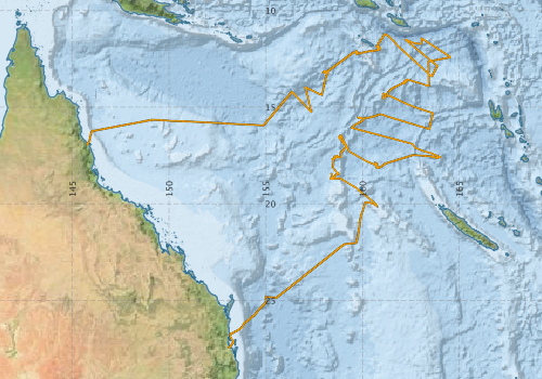
Voyage extents: 27° 26.9' S to 11° 14.2' S 145° 46.8' E to 164° 34.2' E Get voyage track shapefile Get CSV
Marlin Metadata:-
Participants - on ship:-
| Name | Role | Organisation |
|---|---|---|
| Christian Heine | Tectonics/structural geology scientist | University of Sydney |
| Daniela Wolf | Tectonics/potential field student | University of Hamburg |
| Don McKenzie | MNF Voyage Manager | CSIRO Marine and Atmospheric Research |
| Hiski Kippo | MNF Computing Support | CSIRO Marine and Atmospheric Research |
| Jarrod Moore | Tectonics student | University of Sydney |
| Julien Collot | Tectonics/structural geology scientist | Geological Survey of New Caledonia |
| Maria Seton | Chief Scientist | University of Sydney |
| Nicholas Mortimer | Geochemical/geochronology scientist | GNS |
| Peter Dunn | MNF Electronics Support | CSIRO Marine and Atmospheric Research |
| Rick Smith | MNF Swath/TOPAS Support | CSIRO Marine and Atmospheric Research |
| Sabin Zahirovic | Tectonics student | University of Sydney |
| Sebastien Meffre | Geochemical/geochronology scientist | University of Tasmania - Hobart |
| Simon Williams | Tectonics/potential field scientist | University of Sydney |
| Steven Micklethwaite | Structural geology scientist | University of Western Australia |
| TBA | Tectonics/structural geology scientist | Geological Survey of New Caledonia |
This list includes those that may have only been on part of the voyage. See voyage reports on 'Reports and Maps' tab for details.
Marine National Facility Reports - plans, summaries and data processing
-
SS2012_V06 Voyage Plan
- includes objectives, investigator details, proposed data collection, voyage track and equipment to be used.
-
SS2012_V06 Underway Data Processing Report
- details of data processing steps, calibration information, instruments used and any issues with the data.
-
SS2012_V06 Voyage Summary
- includes preliminary results, voyage narrative, types of data collected with C77/ROSCOP codes.
-
SS2012_V06 Scientific Highlight
- report of the key outputs
-

Publications, reports and datasets from this voyage.
Conference abstract
- Seton, Maria,Meffre, Sebastien,Williams, Simon,Micklethwaite, Steven,Mortimer, Nick,Zahirovic, Sabin (2019) Geophysical and geological characterisation of dredge locations from RV voyage ss2012_v06 (ECOSATI): hotspot activity in northern Zealandia. ASEG Extended Abstracts 2018 pp1-8. 10.1071/aseg2018abt5_2a
Conference paper
- Seton, M., Mortimer, N.N, Williams, S.E., Quilty, P., Meffre, S., Gans, P., et al., 2014, Reconstruction of the Melanesian back-arc basins: implications for Ontong Java Plateau accretion, GSA Annual Meeting in Vancouver
- Seton, M., Williams, S., Mortimer, N.N., Meffre, S., Moore, J., Micklethwaite, S., Zahirovic, S. (2013), Constraining back-arc basin formation in the eastern Coral Sea: preliminary results from the ECOSAT voyage. AGU Fall Meeting.
- Williams, S., Gans, P., Mortimer, N., Meffre, S., Seton, M., 2014, Age-progressive volcanism in the Tasman and
Coral seas, AGU Fall Meeting
Dataset
- Smith, S. R.,Lopez, N.,Bourassa, M. A. (2016) SAMOS air‐sea fluxes: 2005–2014. Geoscience Data Journal 3 pp9-19. 10.1002/gdj3.34
Journal Article
- Mather, Ben R.,Müller, R. Dietmar,Seton, Maria,Ruttor, Saskia,Nebel, Oliver,Mortimer, Nick (2020) Intraplate volcanism triggered by bursts in slab flux. Science Advances 6 ppeabd0953-. 10.1126/sciadv.abd0953
- Mortimer, N., Gans, P B., Meffre, S., Martin, C E., Seton, M., Williams, S., Turnbull, R E., Quilty, P G., Micklethwaite, S., Timm, C. (2018) Regional volcanism of northern Zealandia: post-Gondwana break-up magmatism on an extended, submerged continent’, Geological Society, London, Special Publications, vol. 463, no. 1, pp. 199–226
10.1144/SP463.9
- Seton, M, Mortimer, N, Williams, S, Quilty, P & Gans, P et al. (2016) Melanesian back-arc basin and arc development: Constraints from the eastern Coral Sea, Gondwana Research, vol. 39, pp. 77–95, FT130101564 (2014-2020)
10.1016/j.gr.2016.06.011
- Seton, M, Williams, S, Zahirovic, S & Micklethwaite, S (2013) Obituary: Sandy Island (1876-2012). Eos, Transactions American Geophysical Union 94 (141-142) 10.1002/2013eo150001
- Seton, Maria,Williams, Simon,Mortimer, Nick,Meffre, Sebastien,Micklethwaite, Steven,Zahirovic, Sabin (2019) Magma production along the Lord Howe Seamount Chain, northern Zealandia. Geological Magazine 156 pp1605-1617. 10.1017/S0016756818000912
Report
- Seton, M., Williams, S., Mortimer, N., Meffre, S., and Micklethwaite, S. (2017), Voyage report for SS2012V06 Eastern Coral Sea Tectonics (ECOSAT), R/V Southern Surveyor, October–November 2012. GNS Science Report 2016/49. Lower Hutt, New Zealand: GNS Science, 51.
Search for publications, reports and datasets from this and other voyages
Data publishing
This is a list of online datasets hosted by CSIRO. Other processed datasets hosted by collaborating organisations may be found on the 'Metadata' or "Reports, Publications and Maps' tab.
Use the Get data link on the right to extract data using the NCMI Data Trawler.
| Data Stream | Data Summary | Get data | ||||||||||||||
|---|---|---|---|---|---|---|---|---|---|---|---|---|---|---|---|---|
| ADCP Data |
|
Get Data from Trawler Download NetCDF ss2012_v06_ADCP_nc.zip Overview ADCP Dataset HTML Download Processing Report ss2012_v06ADCP.pdf |
||||||||||||||
| Multibeam echosounder |
|
Get Data from Trawler |
||||||||||||||
| SOOP Bio-acoustics |
|
External link
Transect 2 - datafile at IMOS Transect 3 - datafile at IMOS NetCDF Data Format: Manual Download |
||||||||||||||
| Underway |
|
Get Data from Trawler Download 5 sec NetCDF dataset ss2012_v06UWYnc.zip |
Deployments by start time:- Click on column header to sort. Use link on 'Deployment' to see full details. Use the CSV button at the bottom to export data (tab delimited).
Search for deployments from this voyage and others
| Deployment | Operation | Station | Cast | Gear | Project | Start and end times | Start Location | End Location | Depth range | Max Depth | Description | |||
|---|---|---|---|---|---|---|---|---|---|---|---|---|---|---|
| Underway System [details] | Air Temperature Sensor-HMT333,Barometer,Doppler speed log,Fluorometer WS3S-1203,Gill Ultrasonic Wind Sensor,Gill Ultrasonic Wind Sensor,Humidity Sensor-HMT333,IMOS Port Pyranometer-SN 35122F3,IMOS Port Radiometer-SN 35111F3,IMOS Stbd Pyranometer-SN 35123F3,IMOS Stbd Radiometer-SN 35093F3,IMOS rain gauge,IMOS rain gauge,Licor - LI-190SL Q46071,RM Young 05106 wind monitor-75621,RM Young 05106 wind monitor-75621,RM Young 05106 wind monitor-75621,RM Young Rain Gauge,Remote Temperature (T)-SN 2621,Seapath 200,Seapath 200,Seapath 200,Simrad EK60 echosounder,ThermoSalinoGraph (TSG)-SS-SN 1777 | 2401 | 2012-10-26 06:13 | 2012-11-20 02:32 | -16.9283 | 145.7802 | -27.4469 | 153.0782 | ||||||
| Multibeam echosounder [details] | EM300 Multibeam Echosounder | 2012-10-26 07:31 | 2012-11-19 19:49 | -16.8073 | 145.8536 | -26.7189 | 153.2019 | 5987.2 | ||||||
| ADCP Data [details] | RDI Ocean Surveyor Acoustic Doppler current profiler | 2401 | 2012-11-01 02:02 | 2012-11-20 02:36 | -12.1654 | 159.7023 | -27.4469 | 153.0782 | 653.6 | |||||