Voyage details and related metadata, reports, events and data.
SS2009_T02
- is a Marine National Facility ![]() voyage
voyage
Period: 2009-07-30 00:00 to 2009-08-07 00:00 UTC
Duration: 8.00 days
From: Noumea To: Hobart
Region: Pacific Ocean
Ship: Southern Surveyor [details]
Description: Southern Surveyor Transit voyage including some biological sampling in the Tasman Sea.
Leader: J. Young (CMAR)
Project: Determining ecological effects of longline fishing in the eastern tuna and billfish fishery [details]
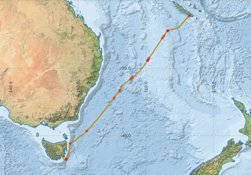
Voyage extents: 43° 42.0' S to 22° 14.6' S 147° 20.6' E to 166° 26.2' E Get voyage track shapefile Get CSV
Marlin Metadata:-
Participants:- no records
Marine National Facility Reports - plans, summaries and data processing
-
SS2009_T02 Voyage Plan
- includes objectives, investigator details, proposed data collection, voyage track and equipment to be used.
-
SS2009_T02 Voyage Summary
- includes preliminary results, voyage narrative, types of data collected with C77/ROSCOP codes.
-
SS2009_T02 Scientific Highlights
- report of the key outputs
-
SS2009_T02 Underway Data Processing Report
- details of data processing steps, calibration information, instruments used and any issues with the data.
-

Publications, reports and datasets from this voyage.
Dataset
- Bakker, Dorothee C E; Pfeil, Benjamin; Smith, Karl; Hankin, Steven; Olsen, Are; Alin, Simone R; Cosca, Catherine E; Harasawa, Sumiko; Kozyr, Alexander; Nojiri, Yukihiro; O'Brien, Kevin M; Schuster, Ute; Telszewski, Maciej; Tilbrook, Bronte; Wada, Chisato; Akl, John; Barbero, Leticia; Bates, Nicolas R; Boutin, Jacqueline; Bozec, Yann; Cai, Wei-Jun; Castle, Robert D; Chavez, Francisco P; Chen, Lei; Chierici, Melissa; Currie, Kim I; de Baar, Hein J W; Evans, Wiley; Feely, Richard A; Fransson, Agneta; Gao, Zhongyong; Hales, Burke; Hardman-Mountford, Nicolas J; Hoppema, Mario; Huang, Wei-Jen; Hunt, Christopher W; Huss, Betty; Ichikawa, Tadafumi; Johannessen, Truls; Jones, Elizabeth M; Jones, Steve D; Jutterstrøm, Sara; Kitidis, Vassilis; Körtzinger, Arne; Landschützer, Peter; Lauvset, Siv K; Lefèvre, Nathalie; Manke, Ansley; Mathis, Jeremy T; Merlivat, Liliane; Metzl, Nicolas; Murata, Akihiko; Newberger, Timothy; Omar, Abdirahman M; Ono, Tsuneo; Park, Geun-Ha; Paterson, Kristina; Pierrot, Denis; Ríos, Aida F; Sabine, Christopher L; Saito, Shu; Salisbury, Joe; Sarma, Vedula V S S; Schlitzer, Reiner; Sieger, Rainer; Skjelvan, Ingunn; Steinhoff, Tobias; Sullivan, Kevin; Sun, Heng; Sutton, Adrienne; Suzuki, Toru; Sweeney, Colm; Takahashi, Taro; Tjiputra, Jerry; Tsurushima, Nobuo; van Heuven, Steven; Vandemark, Doug; Vlahos, Penny; Wallace, Douglas WR; Wanninkhof, Rik; Watson, Andrew J (2014): Surface Ocean CO2 Atlas (SOCAT) V2. PANGAEA, 10.1594/PANGAEA.811776
- Smith, S. R.,Lopez, N.,Bourassa, M. A. (2016) SAMOS air‐sea fluxes: 2005–2014. Geoscience Data Journal 3 pp9-19. 10.1002/gdj3.34
Search for publications, reports and datasets from this and other voyages
Data publishing
This is a list of online datasets hosted by CSIRO. Other processed datasets hosted by collaborating organisations may be found on the 'Metadata' or "Reports, Publications and Maps' tab.
Use the Get data link on the right to extract data using the NCMI Data Trawler.
| Data Stream | Data Summary | Get data | ||||||||||||
|---|---|---|---|---|---|---|---|---|---|---|---|---|---|---|
| CTD profile |
|
Get Data from Trawler Download NetCDF data ss2009_t02_CTDnc.zip Processing report: ss2009_t02ctd.pdf Download CTD Scan Plots (.eps) ss2009_t02_CTDScan_eps.zip |
||||||||||||
| Hydrology | No data | |||||||||||||
| Multibeam echosounder |
|
Get Data from Trawler |
||||||||||||
| pCO2 |
|
External link - download datafile at IMOS |
||||||||||||
| Underway |
|
Get Data from Trawler Download NetCDF file ss2009_t02UWYnc.zip |
||||||||||||
| XBT Profile |
|
Get Data from Trawler Download xbt_ascii_ma_2007_2012.zip (MEDS ASCII format ) Download xbt_nc_ss2007_2012.zip (NetCDF format) |
Deployments by start time:- Click on column header to sort. Use link on 'Deployment' to see full details. Use the CSV button at the bottom to export data (tab delimited).
Search for deployments from this voyage and others
| Deployment | Operation | Station | Cast | Gear | Project | Start and end times | Start Location | End Location | Depth range | Max Depth | Description | |||
|---|---|---|---|---|---|---|---|---|---|---|---|---|---|---|
| Underway System [details] | Air Temperature Sensor-HMT333,Barometer,Fluorometer WS3S-443P,Gyro-Generic SS-NF,Humidity Sensor-HMP233,IMOS Port Pyranometer-SN 35122F3,IMOS Port Radiometer-SN 35111F3,IMOS Stbd Pyranometer-SN 35123F3,IMOS Stbd Radiometer-SN 35093F3,IMOS rain gauge,IMOS rain gauge,IMOS wind monitor,IMOS wind monitor,IMOS wind monitor,IMOS wind monitor,Licor-UWQ 3708,RM Young 05106 wind monitor-75621,RM Young 05106 wind monitor-75621,RM Young 05106 wind monitor-75621,RM Young Rain Gauge,Remote Temperature (T)-SN 2621,Seapath 200,Seapath 200,Ships log,Simrad EA500 Echosounder,ThermoSalinoGraph (TSG)-SS-SN 1777 | 1863 | 2009-07-29 21:27 | 2009-08-06 20:50 | -22.2651 | 166.4367 | -42.8848 | 147.3435 | ||||||
| XBT Cast [details] | Sippican Deep Blue | 2391 | 2009-07-30 21:45 | -24.4295 | 163.2440 | 1100.3 | ||||||||
| Multibeam echosounder [details] | EM300 Multibeam Echosounder | 2009-07-30 21:55 | 2009-08-06 19:39 | -24.4479 | 163.1915 | -42.9435 | 147.3766 | 5623.3 | ||||||
| CTD Cast [details] | 3 | Cast 3 | CTD 21,Conductivity CTD 21-SN 2312,Fluorometer-CTD 21 -Chelsea-06-5941-001,Oxygen CTD 21-SBE 43-SN 1794,Pressure CTD 21,Temperature CTD 21 - SN 4718 | 1863 | 2009-07-31 05:41 | 2009-07-31 06:21 | -25.2199 | 162.6589 | -25.2216 | 162.6551 | 1004 | |||
| XBT Cast [details] | Sippican Deep Blue | 2391 | 2009-07-31 11:15 | -25.5474 | 162.4217 | 1100.3 | ||||||||
| CTD Cast [details] | 4 | Cast 4 | CTD 21,Conductivity CTD 21-SN 2312,Fluorometer-CTD 21 -Chelsea-06-5941-001,Oxygen CTD 21-SBE 43-SN 1794,Pressure CTD 21,Temperature CTD 21 - SN 4718 | 1863 | 2009-08-01 06:07 | 2009-08-01 06:49 | -28.5324 | 160.4360 | -28.5247 | 160.4310 | 1000 | |||
| XBT Cast [details] | Sippican Deep Blue | 2391 | 2009-08-01 11:15 | -28.8379 | 160.2708 | 1100.3 | ||||||||
| XBT Cast [details] | Sippican Deep Blue | 2391 | 2009-08-01 11:20 | -28.8417 | 160.2698 | 996.2 | ||||||||
| CTD Cast [details] | 5 | Cast 5 | CTD 21,Conductivity CTD 21-SN 2312,Fluorometer-CTD 21 -Chelsea-06-5941-001,Oxygen CTD 21-SBE 43-SN 1794,Pressure CTD 21,Temperature CTD 21 - SN 4718 | 1863 | 2009-08-02 06:08 | 2009-08-02 06:45 | -31.3479 | 158.0125 | -31.3488 | 158.0168 | 1000 | |||
| XBT Cast [details] | Sippican Deep Blue | 2391 | 2009-08-02 11:37 | -31.6244 | 157.7726 | 1100.3 | ||||||||
| XBT Cast [details] | Sippican Deep Blue | 2391 | 2009-08-03 00:45 | -33.2976 | 156.1098 | 498.1 | ||||||||
| XBT Cast [details] | Sippican Deep Blue | 2391 | 2009-08-03 11:43 | -34.4307 | 155.2924 | 741.6 | ||||||||
| XBT Cast [details] | Sippican Deep Blue | 2391 | 2009-08-04 22:07 | -39.3117 | 151.2584 | 1100.3 | ||||||||
| XBT Cast [details] | Sippican Deep Blue | 2391 | 2009-08-05 13:24 | -41.1680 | 148.8166 | 1092 | ||||||||
| XBT Cast [details] | Sippican Deep Blue | 2391 | 2009-08-06 08:09 | -43.4696 | 148.2136 | 1100.3 | ||||||||
| XBT Cast [details] | Sippican Deep Blue | 2391 | 2009-08-06 08:20 | -43.4870 | 148.1980 | 1100.3 | ||||||||