Survey details and related metadata, reports, events and data.
SO 1/87 (alternative identifier: SO198701)
Period: 1987-01-10 00:00 to 1987-02-07 00:00 Local
Duration: 28.00 days
Region: East Indian Ocean
Ship: Soela [details]
Description: Soela cruise SO 1/87 was undertaken for a tuna larval and tuna fish survey including oceanographical studies in the east Indian Ocean, mainly within the boundaries of 15 - 17 degrees S and 115 - 117 degrees E. Cruise aims were to determine the distribution of larvae in relation to the thermocline, time of day and moon phase. To investigate the oceanography of the area and to complete a CTD section from Port Hedland to the study area. To investigate the composition and abundance of phytoplankton and zooplankton in the area. To collect larvae samples for biological studies and capture mature tuna by line and troll fishing. Deployment of three satellite tracked buoys, two within the study area and one at approximately 18 degrees S, 117 degrees E. To rendezvous with the Japanese Research Vessel "Shoyo Maru" to carry out joint sampling and calibration of Japanese sampling techniques. To carry out experimental light fishing for post-larval and juvenile tunas with a Boukiami dip-net.
Leader: T. Davis (CSIRO)
Project: "Soela" fish surveys, 1980s [details]
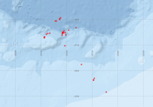
Voyage extents: 18° 50.5' S to 15° 56.1' S 115° 07.6' E to 117° 33.0' E
Marlin Metadata:-
Participants:- no records
Marine National Facility Reports - plans, summaries and data processing
- View the Survey plan - includes objectives, investigator details, proposed data collection, voyage track and equipment to be used.
- View the Survey Summary report - includes preliminary results, voyage narrative, types of data collected with C77/ROSCOP codes.
- There is no map for this survey.
Search for publications, reports and datasets from this and other voyages
Data publishing
This is a list of online datasets hosted by CSIRO. Other processed datasets hosted by collaborating organisations may be found on the 'Metadata' or "Reports, Publications and Maps' tab.
Use the Get data link on the right to extract data using the NCMI Data Trawler.
| Data Stream | Data Summary | Get data | ||||||||||
|---|---|---|---|---|---|---|---|---|---|---|---|---|
| Hydrology |
|
Get Data from Trawler |
Deployments by start time:- Click on column header to sort. Use link on 'Deployment' to see full details. Use the CSV button at the bottom to export data (tab delimited).
Search for deployments from this voyage and others
| Deployment | Operation | Station | Cast | Gear | Project | Start and end times | Start Location | End Location | Depth range | Max Depth | Description | |||
|---|---|---|---|---|---|---|---|---|---|---|---|---|---|---|
| Hydrology Cast [details] | 1 | 35 | 1987-01-10 20:50 | 1987-01-10 21:38 | -18.3672 | 117.0500 | -18.3680 | 117.0512 | 795 | |||||
| Hydrology Cast [details] | 1 | 35 | 1987-01-10 21:56 | 1987-01-10 22:35 | -18.3693 | 117.0528 | -18.3713 | 117.0550 | 794 | |||||
| Hydrology Cast [details] | 1 | 35 | 1987-01-14 10:32 | 1987-01-14 11:25 | -16.6908 | 115.1397 | -16.6937 | 115.1403 | 488 | |||||
| Hydrology Cast [details] | 1 | 35 | 1987-01-14 21:38 | 1987-01-14 22:29 | -16.6820 | 115.1338 | -16.6822 | 115.1338 | 154 | |||||
| Hydrology Cast [details] | 1 | 35 | 1987-01-15 10:05 | 1987-01-15 10:45 | -16.5807 | 115.2102 | -16.5770 | 115.2148 | 150 | |||||
| Hydrology Cast [details] | 1 | 35 | 1987-01-15 21:45 | 1987-01-15 22:52 | -16.5468 | 115.2637 | -16.5498 | 115.2647 | 470 | |||||
| Hydrology Cast [details] | 1 | 35 | 1987-01-16 09:55 | 1987-01-16 10:30 | -16.7182 | 115.1273 | -16.7090 | 115.1417 | 149 | |||||
| Hydrology Cast [details] | 1 | 35 | 1987-01-16 21:55 | 1987-01-16 22:29 | -16.5380 | 115.3457 | -16.5385 | 115.3458 | 151 | |||||
| Hydrology Cast [details] | 1 | 35 | 1987-01-20 21:40 | 1987-01-20 22:32 | -16.0012 | 115.7348 | 505 | |||||||
| Hydrology Cast [details] | 1 | 35 | 1987-01-21 10:18 | 1987-01-21 10:46 | -15.9700 | 115.7260 | -15.9653 | 115.7277 | 152 | |||||
| Hydrology Cast [details] | 1 | 35 | 1987-01-21 21:50 | 1987-01-21 22:25 | -15.9358 | 115.7653 | 152 | |||||||
| Hydrology Cast [details] | 1 | 35 | 1987-01-22 14:50 | 1987-01-22 15:46 | -17.0300 | 115.9338 | 501 | |||||||
| Hydrology Cast [details] | 1 | 35 | 1987-01-22 21:35 | 1987-01-22 22:26 | -17.7597 | 116.5822 | -17.7600 | 116.5822 | 492 | |||||
| Hydrology Cast [details] | 1 | 35 | 1987-01-23 03:12 | 1987-01-23 04:02 | -18.3020 | 117.0828 | -18.3055 | 117.0875 | 494 | |||||
| Hydrology Cast [details] | 1 | 35 | 1987-01-23 10:04 | 1987-01-23 10:38 | -18.8422 | 117.5507 | -18.8433 | 117.5508 | 203 | |||||
| Hydrology Cast [details] | 1 | 35 | 1987-01-26 10:16 | 1987-01-26 10:56 | -16.0622 | 115.5602 | -16.0657 | 115.5997 | 792 | |||||
| Hydrology Cast [details] | 1 | 35 | 1987-01-26 11:57 | 1987-01-26 12:31 | -16.0610 | 115.5997 | 152 | |||||||
| Hydrology Cast [details] | 1 | 35 | 1987-01-28 01:20 | 1987-01-28 02:12 | -16.3205 | 116.3717 | -16.3183 | 116.3717 | 502 | |||||
| Hydrology Cast [details] | 1 | 35 | 1987-01-28 10:00 | 1987-01-28 10:50 | -16.5047 | 115.8423 | -16.5023 | 115.8467 | 500 | |||||
| Hydrology Cast [details] | 1 | 35 | 1987-01-28 21:38 | 1987-01-28 22:08 | -16.5177 | 115.9508 | -16.5180 | 115.9508 | 150 | |||||
| Hydrology Cast [details] | 1 | 35 | 1987-01-29 10:02 | 1987-01-29 10:35 | -16.4463 | 115.9008 | 152 | |||||||
| Hydrology Cast [details] | 1 | 35 | 1987-01-29 21:48 | 1987-01-29 22:39 | -16.4182 | 116.0838 | 494 | |||||||
| Hydrology Cast [details] | 1 | 35 | 1987-01-30 10:36 | 1987-01-30 11:08 | -16.6190 | 115.8257 | -16.6193 | 115.8257 | 143 | |||||
| Hydrology Cast [details] | 1 | 35 | 1987-01-30 21:37 | 1987-01-30 22:08 | -16.6022 | 115.9672 | -16.6023 | 115.9672 | 150 | |||||
| Hydrology Cast [details] | 1 | 35 | 1987-01-31 11:08 | 1987-01-31 11:39 | -16.5387 | 115.8503 | -16.5397 | 115.8508 | 138 | |||||
| Hydrology Cast [details] | 1 | 35 | 1987-01-31 21:51 | 1987-01-31 22:37 | -16.5158 | 115.8497 | 486 | |||||||
| Hydrology Cast [details] | 1 | 35 | 1987-02-01 11:22 | 1987-02-01 11:59 | -16.5145 | 115.8900 | 167 | |||||||
| Hydrology Cast [details] | 1 | 35 | 1987-02-01 22:10 | 1987-02-01 22:41 | -16.4880 | 115.8663 | -16.4883 | 115.8663 | 150 | |||||
| Hydrology Cast [details] | 1 | 35 | 1987-02-02 10:37 | 1987-02-02 11:31 | -16.5592 | 115.8360 | -16.5620 | 115.8353 | 475 | |||||