Survey details and related metadata, reports, events and data.
SO 6/80 (alternative identifier: SO198006)
Period: 1980-09-01 00:00 to 1980-09-23 00:00 Local
Duration: 22.00 days
Region: Great Australian Bight
Ship: Soela [details]
Description: Soela cruise SO 6/80 sailed from Fremantle to the Great Australian Bight to undertake an acoustic survey of pelagic fish. Primary objectives were to examine hydrological (surface water samples for temperature and salinity were taken every 3 hours while in transit from Fremantle and every 2 hours in the survey area) and biological conditions in the area and to collect material from pelagic fish catches for life history studies. Secondary objectives included a diel feeding study of demersal fish, sampling of apex predators and collection of cephalopods for taxonomy and life history studies. Survey methods included acoustics, midwater and demersal trawls, Nansen casts, XBTs, secchi disk readings, variosens profiles, dropnet casts, bongo and surface net tows, trolling and squid jigging.
Leader: J. Stevens (CSIRO)
Project: "Soela" fish surveys, 1980s [details]
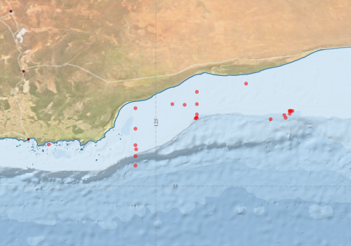
Voyage extents: 34° 30.0' S to 32° 30.0' S 124° 30.0' E to 128° 20.0' E
Marlin Metadata:-
Metadata from OBIS Australia datasets:- biological data is published via the OBIS-AU IPT server and delivered to one or more of OBIS, ALA and GBIF
Download from OBIS Australia IPT View at - Ocean Biodiversity Information System (OBIS) Atlas of Living Australia (ALA) GBIF
Participants:- no records
Marine National Facility Reports - plans, summaries and data processing
- View the Survey plan - includes objectives, investigator details, proposed data collection, voyage track and equipment to be used.
- View the Survey Summary report - includes preliminary results, voyage narrative, types of data collected with C77/ROSCOP codes.
-

Search for publications, reports and datasets from this and other voyages
Data publishing
This is a list of online datasets hosted by CSIRO. Other processed datasets hosted by collaborating organisations may be found on the 'Metadata' or "Reports, Publications and Maps' tab.
Use the Get data link on the right to extract data using the NCMI Data Trawler.
| Data Stream | Data Summary | Get data | ||||||||||
|---|---|---|---|---|---|---|---|---|---|---|---|---|
| Marine biodiversity observations and/or samples |
|
Get Data from Trawler |
||||||||||
| Catch Details (deprecated - now bio) |
|
Get Data from Trawler |
||||||||||
| Hydrology |
|
Get Data from Trawler |
Deployments by start time:- Click on column header to sort. Use link on 'Deployment' to see full details. Use the CSV button at the bottom to export data (tab delimited).
Search for deployments from this voyage and others
| Deployment | Operation | Station | Cast | Gear | Project | Start and end times | Start Location | End Location | Depth range | Max Depth | Description | |||
|---|---|---|---|---|---|---|---|---|---|---|---|---|---|---|
| Hydrology Cast [details] | 1 | 35 | 1980-09-04 00:00 | 1980-09-04 00:00 | -34.5000 | 124.5000 | 293 | |||||||
| Hydrology Cast [details] | 1 | 35 | 1980-09-05 00:00 | 1980-09-05 00:00 | -34.2667 | 124.5000 | 295 | |||||||
| Hydrology Cast [details] | 1 | 35 | 1980-09-05 00:00 | 1980-09-05 00:00 | -34.0000 | 124.5000 | 60 | |||||||
| Hydrology Cast [details] | 1 | 35 | 1980-09-05 00:00 | 1980-09-05 00:00 | -33.6000 | 124.5000 | 50 | |||||||
| Hydrology Cast [details] | 1 | 35 | 1980-09-05 00:00 | 1980-09-05 00:00 | -33.1000 | 124.5000 | 35 | |||||||
| Catch [details] | 1 | Engel midwater | 35 | 1980-09-05 09:15 | 1980-09-05 10:30 | -34.1000 | 124.5167 | 82 | Trawling | |||||
| Catch [details] | 2 | Engel high-opening bottom trawl | 35 | 1980-09-15 09:20 | 1980-09-15 10:13 | -33.9833 | 122.3833 | -34.0333 | 122.3667 | 50 | Trawling | |||
| Hydrology Cast [details] | 1 | 35 | 1980-09-17 00:00 | 1980-09-17 00:00 | -33.0000 | 125.4000 | 45 | |||||||
| Hydrology Cast [details] | 1 | 35 | 1980-09-17 00:00 | 1980-09-17 00:00 | -32.7000 | 126.0000 | 45 | |||||||
| Hydrology Cast [details] | 1 | 35 | 1980-09-17 00:00 | 1980-09-17 00:00 | -33.0000 | 126.0000 | 55 | |||||||
| Catch [details] | 3 | Engel high-opening bottom trawl | 35 | 1980-09-17 08:30 | 1980-09-17 11:08 | -33.0167 | 125.7000 | -32.9667 | 125.7833 | 60 | Trawling | |||
| Hydrology Cast [details] | 1 | 35 | 1980-09-18 00:00 | 1980-09-18 00:00 | -33.3333 | 126.0000 | 107 | |||||||
| Hydrology Cast [details] | 1 | 35 | 1980-09-18 00:00 | 1980-09-18 00:00 | -32.5000 | 127.2000 | 30 | |||||||
| Catch [details] | 4 | Engel midwater | 35 | 1980-09-18 01:10 | 1980-09-18 02:00 | -33.2500 | 126.0000 | -33.2667 | 126.0000 | 40 | Trawling | |||
| Catch [details] | 5 | Engel midwater | 35 | 1980-09-18 07:00 | 1980-09-18 08:15 | -33.3500 | 125.9667 | -33.3333 | 125.9833 | 70 | Trawling | |||
| Catch [details] | 6 | Engel midwater | 35 | 1980-09-18 08:00 | 1980-09-18 09:15 | -33.3333 | 125.9833 | -33.3000 | 126.0167 | 70 | Trawling | |||
| Hydrology Cast [details] | 1 | 35 | 1980-09-19 00:00 | 1980-09-19 00:00 | -33.3667 | 127.8000 | 150 | |||||||
| Catch [details] | 54 | Demersal Frank & Bryce trawl | 35 | 1980-09-19 17:40 | 1980-09-19 19:20 | -33.2333 | 128.2667 | -33.2833 | 128.2000 | 140 | Trawling | |||
| Catch [details] | 55 | Demersal Frank & Bryce trawl | 35 | 1980-09-19 20:00 | 1980-09-19 21:40 | -33.2667 | 128.1333 | -33.2167 | 128.2167 | 140 | Trawling | |||
| Catch [details] | 50 | Engel high-opening bottom trawl | 35 | 1980-09-19 20:40 | 1980-09-19 22:03 | -33.1667 | 128.2667 | 120 | Trawling | |||||
| Hydrology Cast [details] | 1 | 35 | 1980-09-20 00:00 | 1980-09-20 00:00 | -33.1667 | 128.3333 | 120 | |||||||
| Catch [details] | 51 | Engel high-opening bottom trawl | 35 | 1980-09-20 02:25 | 1980-09-20 04:05 | -33.1667 | 128.3000 | 120 | Trawling | |||||
| Catch [details] | 52 | Engel high-opening bottom trawl | 35 | 1980-09-20 06:45 | 1980-09-20 08:25 | -33.3333 | 128.1667 | -33.3667 | 128.1333 | 200 | Trawling | |||
| Catch [details] | 53 | Engel high-opening bottom trawl | 35 | 1980-09-20 08:30 | 1980-09-20 10:10 | -33.1667 | 128.2667 | -33.1500 | 128.2000 | 124 | Trawling | |||