Voyage details and related metadata, reports, events and data.
IN2019_E01
- is a Marine National Facility ![]() voyage
voyage
Title: Calibration, Trials and Upcoming Voyage User Equipment Testing
Period: 2019-07-19 22:30 to 2019-08-02 02:00 UTC
Duration: 13.15 days
From: Singapore To: Cairns
Region: Indian Ocean; Timor Sea; Arafura Sea; Coral Sea; Great Barrier Reef; Queensland coast northeast.
Ship: Investigator (RV) [details]
Description:
Project: Investigator - general vessel operations, gear trials, etc. [details] Primary
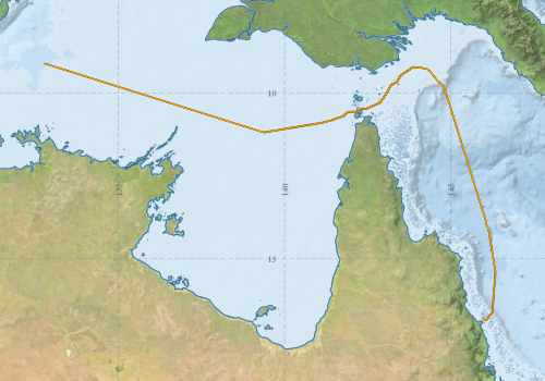
Voyage extents: 16° 50.6' S to 9° 07.0' S 132° 47.1' E to 146° 20.7' E Get voyage track shapefile Get CSV
Marlin Metadata:-
Cruise Summary Report at SeaDataNet:-
Participants - on ship:-
| Name | Role | Organisation | Project |
|---|---|---|---|
| Jason Fazey | Voyage Manager | Marine National Facility | Voyage Management on RV Investigator |
This list includes those that may have only been on part of the voyage. See voyage reports on 'Reports and Maps' tab for details.
Marine National Facility Reports - plans, summaries and data processing
-
IN2019_E01 ADCP Processing Report
- details of data processing steps, calibration information, instruments used and any issues with the data.
- View Survey map
Publications, reports and datasets from this voyage.
Dataset
- Fazey, Jason; Nau, Amy; Boyd, Matt; Navidad, Cisco; & Fox, Ruby (2024): IN2019_E01 Arafura and Coral Sea Bathymetry 10m - 210m Multi-resolution AusSeabed products. v1. CSIRO. Data Collection. 10.25919/s8sn-gh54
Search for publications, reports and datasets from this and other voyages
Data publishing
This is a list of online datasets hosted by CSIRO. Other processed datasets hosted by collaborating organisations may be found on the 'Metadata' or "Reports, Publications and Maps' tab.
Use the Get data link on the right to extract data using the NCMI Data Trawler.
| Data Stream | Data Summary | Get data | ||||||||||
|---|---|---|---|---|---|---|---|---|---|---|---|---|
| ADCP Data |
|
Get Data from Trawler Download ADCP Data (os150 netcdf) in2019_e01_os150nb_nc.zip Download overview plots of collected data: in2019_e01_os75nb_webpy.zip Download overview plots of collected data: in2019_e01_os150nb_webpy.zip Download ADCP Data (os75 netcdf) in2019_e01_os75nb_nc.zip |
||||||||||
| Multibeam echosounder |
|
Get Data from Trawler |
||||||||||
| pCO2 |
|
External link - download datafile at IMOS Data fields and units document (.pdf) |
||||||||||
| Radon measurements |
|
Get Data from Trawler Download RV Investigator Radon dataset (XLSX) |
||||||||||
| Sub-bottom profiler |
|
Get Data from Trawler Geophysical Survey and Mapping data acquisition and processing report |
||||||||||
| Singlebeam echosounder |
|
Get Data from Trawler Geophysical Survey and Mapping acquisition report |
||||||||||
| SOOP Bio-acoustics |
|
External link - datafile at IMOS NetCDF Data Format: Manual Download |
||||||||||
| XBT Profile |
|
Get Data from Trawler |
| ID | When (UTC) | Lat | Long | Instrument | Identifier | Action | Log | Subject / Comment |
|---|
Deployments by start time:- Click on column header to sort. Use link on 'Deployment' to see full details. Use the CSV button at the bottom to export data (tab delimited).
Search for deployments from this voyage and others
| Deployment | Operation | Station | Cast | Gear | Project | Start and end times | Start Location | End Location | Depth range | Max Depth | Description | |||
|---|---|---|---|---|---|---|---|---|---|---|---|---|---|---|
| ADCP Data [details] | Teledyne RDI ADCP 75 kHz | 2457 | 2019-07-27 20:25 | 2019-08-02 11:56 | -9.1745 | 132.9656 | -16.9258 | 145.7807 | 782 | |||||
| XBT Cast [details] | 2391 | 2019-07-27 21:16 | 404.9 | |||||||||||
| XBT Cast [details] | 2391 | 2019-07-30 16:11 | 1100.3 | |||||||||||
| XBT Cast [details] | 2391 | 2019-07-30 16:19 | 1100.3 | |||||||||||
| XBT Cast [details] | 2391 | 2019-07-30 19:55 | 996.8 | |||||||||||