Please login if you have access to particular applications.
Catch Data - from CSIRO surveys.
| CAAB Code: | 37 355022 [taxon report] |
| Scientific Name and Authority: | Parupeneus barberinus (Lacépède, 1801) |
| CAAB category: | 37 - Pisces |
| Standard Name (AS 5300): | Dot-and-dash Goatfish |
Distribution map:
View detailed map or click on map to see same.
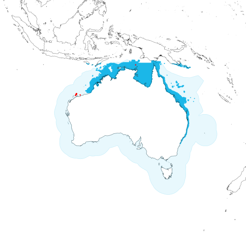
Modelled distribution shown as blue polygon (source: Australian National Fish Expert Distributions) Updated on 2008-11-19.
Occurrence locations [10] shown as red circles - View CSIRO Catch records Get expert distribution shapefile
View detailed map or click on map to see same.
Modelled distribution shown as blue polygon (source: Australian National Fish Expert Distributions) Updated on 2008-11-19.
Occurrence locations [10] shown as red circles - View CSIRO Catch records Get expert distribution shapefile
Catch records - 10 records found.
Click on survey to see survey details. Click on Operation to see full details of the catch. Use the CSV button at the bottom to export data.
| Date (UTC) | Position | Survey | Operation | Depth Range (m) | Count | Weight (kg) | Method | Effort | Gear |
|---|---|---|---|---|---|---|---|---|---|
| 1967-02-28 00:00 | 20° 12.1' S 117° 48.1' E | LIRA196702 | 51 | 26 to 28 | 1 | Trawl | 60 minutes | ||
| 1967-03-03 00:00 | 19° 59.0' S 116° 34.1' E | LIRA196702 | 71 | 58 to 58 | 2 | Trawl | 60 minutes | ||
| 1967-03-03 00:00 | 19° 56.0' S 116° 38.0' E | LIRA196702 | 72 | 58 to 58 | 9 | Trawl | 60 minutes | ||
| 1967-03-03 00:00 | 19° 51.1' S 116° 36.1' E | LIRA196702 | 73 | 60 to 61 | 1 | Trawl | 60 minutes | ||
| 1967-03-04 00:00 | 20° 08.0' S 116° 25.1' E | LIRA196702 | 77 | 50 to 50 | 6 | Trawl | 60 minutes | ||
| 1967-03-04 00:00 | 20° 00.0' S 116° 24.0' E | LIRA196702 | 80 | 5 | Trawl | ||||
| 1967-03-05 00:00 | 19° 47.0' S 116° 36.2' E | LIRA196702 | 97 | 58 to 61 | 6 | Trawl | 60 minutes | ||
| 1967-03-05 00:00 | 19° 46.1' S 116° 32.0' E | LIRA196702 | 93 | 56 to 60 | 30 | Trawl | 60 minutes | ||
| 1975-03-09 00:00 | 10° 36.0' S 136° 12.0' E | RADU197503 | 2 | 50 to 50 | 3 | Trawl | 60 minutes | ||
| 1977-05-10 00:00 | 20° 20.0' S 116° 12.0' E | P-DER197701 | 44 | 45 to 45 | 16 | 4 | Trawl | 107 minutes |