Please login if you have access to particular applications.
Catch Data - from CSIRO surveys.
| CAAB Code: | 37 087002 [taxon report] |
| Scientific Name and Authority: | Chirocentrus nudus Swainson, 1839 |
| CAAB category: | 37 - Pisces |
| Standard Name (AS 5300): | Whitefin Wolf Herring |
Distribution map:
View detailed map or click on map to see same.
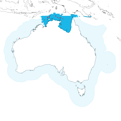
Modelled distribution shown as blue polygon (source: Australian National Fish Expert Distributions) Updated on 2009-01-06.
Occurrence locations [19] shown as red circles - View CSIRO Catch records Get expert distribution shapefile
View detailed map or click on map to see same.
Modelled distribution shown as blue polygon (source: Australian National Fish Expert Distributions) Updated on 2009-01-06.
Occurrence locations [19] shown as red circles - View CSIRO Catch records Get expert distribution shapefile
Catch records - 19 records found.
Click on survey to see survey details. Click on Operation to see full details of the catch. Use the CSV button at the bottom to export data.
| Date (UTC) | Position | Survey | Operation | Depth Range (m) | Count | Weight (kg) | Method | Effort | Gear |
|---|---|---|---|---|---|---|---|---|---|
| 1967-05-28 00:00 | 10° 59.1' S 135° 48.0' E | BERG196705 | 12 | 50 to 50 | 2 | Trawl | 90 minutes | ||
| 1967-05-28 00:00 | 10° 41.0' S 135° 05.1' E | BERG196705 | 9 | 55 to 55 | 1 | Trawl | 60 minutes | ||
| 1967-05-29 00:00 | 11° 22.2' S 137° 39.0' E | BERG196705 | 16 | 50 to 50 | 1 | Trawl | 60 minutes | ||
| 1967-06-03 00:00 | 10° 48.0' S 136° 16.0' E | BERG196705 | 51 | 45 to 46 | 8 | Trawl | 60 minutes | ||
| 1967-06-03 00:00 | 10° 48.1' S 136° 40.0' E | BERG196705 | 50 | 52 to 52 | 5 | Trawl | 60 minutes | ||
| 1967-06-05 00:00 | 10° 37.1' S 131° 10.0' E | BERG196705 | 64 | 69 to 69 | 3 | Trawl | 60 minutes | ||
| 1967-06-05 00:00 | 10° 45.1' S 130° 21.0' E | BERG196705 | 65 | 70 to 72 | 4 | Trawl | 60 minutes | ||
| 1967-06-06 00:00 | 11° 51.0' S 128° 46.0' E | BERG196705 | 68 | 66 to 69 | 2 | Trawl | 60 minutes | ||
| 1967-06-17 00:00 | 20° 13.0' S 116° 43.0' E | BERG196705 | 153 | 47 to 49 | 3 | Trawl | 60 minutes | ||
| 1967-07-09 00:00 | 10° 48.1' S 130° 26.0' E | BERG196705 | 318 | 65 to 65 | 3 | Trawl | 60 minutes | ||
| 1967-07-09 00:00 | 10° 32.1' S 130° 23.1' E | BERG196705 | 319 | 87 to 90 | 3 | Trawl | 60 minutes | ||
| 1967-07-10 00:00 | 10° 15.0' S 131° 07.0' E | BERG196705 | 328 | 85 to 88 | 5 | Trawl | 60 minutes | ||
| 1967-07-10 00:00 | 10° 26.1' S 131° 10.1' E | BERG196705 | 327 | 75 to 78 | 2 | Trawl | 60 minutes | ||
| 1967-07-10 00:00 | 9° 40.1' S 131° 33.1' E | BERG196705 | 330 | 118 to 120 | 1 | Trawl | 60 minutes | ||
| 1967-07-12 00:00 | 10° 00.1' S 134° 04.1' E | BERG196705 | 343 | 87 to 88 | 3 | Trawl | 60 minutes | ||
| 1967-07-12 00:00 | 10° 01.0' S 134° 21.0' E | BERG196705 | 344 | 71 to 73 | 5 | Trawl | 60 minutes | ||
| 1967-07-13 00:00 | 10° 36.0' S 135° 06.1' E | BERG196705 | 350 | 55 to 60 | 2 | Trawl | 60 minutes | ||
| 1967-07-15 00:00 | 9° 35.1' S 136° 57.2' E | BERG196705 | 365 | 45 to 47 | 2 | Trawl | 60 minutes | ||
| 1972-11-04 00:00 | 13° 10.0' S 127° 42.0' E | RADU197206 | 326 | 65 to 80 | 2 | Trawl | 37 minutes |