Please login if you have access to particular applications.
Catch Data - from CSIRO surveys.
| CAAB Code: | 37 042010 [taxon report] |
| Scientific Name and Authority: | Hydrolagus homonycteris Didier, 2008 |
| CAAB category: | 37 - Pisces |
| Standard Name: | Black whitefin |
Distribution map:
View detailed map or click on map to see same.
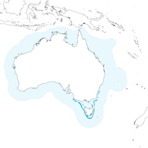
Modelled distribution shown as blue polygon (source: Australian National Fish Expert Distributions) Updated on 2008-11-19.
Occurrence locations [6] shown as red circles - View CSIRO Catch records Get expert distribution shapefile
View detailed map or click on map to see same.
Modelled distribution shown as blue polygon (source: Australian National Fish Expert Distributions) Updated on 2008-11-19.
Occurrence locations [6] shown as red circles - View CSIRO Catch records Get expert distribution shapefile
Catch records - 6 records found.
Click on survey to see survey details. Click on Operation to see full details of the catch. Use the CSV button at the bottom to export data.
| Date (UTC) | Position | Survey | Operation | Depth Range (m) | Count | Weight (kg) | Method | Effort | Gear |
|---|---|---|---|---|---|---|---|---|---|
| 2003-05-11 07:37 | 34° 03.2' S 171° 08.1' E | TAN0308 | 3 | 1051 to 1320 | 1 | 2.7 | Trawl | ||
| 2003-05-26 07:51 | 34° 12.2' S 163° 21.4' E | TAN0308 | 90 | 1090 to 1117 | 2 | 6.7 | Trawl | ||
| 2003-05-26 12:38 | 34° 12.7' S 163° 21.6' E | TAN0308 | 92 | 1082 to 1120 | 5 | 16 | Trawl | ||
| 2003-05-30 05:47 | 32° 36.6' S 167° 50.3' E | TAN0308 | 120 | 1303 to 1313 | 1 | 3.2 | Trawl | ||
| 2003-05-30 09:32 | 32° 36.4' S 167° 50.6' E | TAN0308 | 121 | 1331 to 1345 | 3 | 8.6 | Trawl | ||
| 2003-05-31 16:50 | 33° 29.2' S 170° 00.7' E | TAN0308 | 129 | 1158 to 1230 | 1 | 2.4 | Trawl |