Please login if you have access to particular applications.
Catch Data - from CSIRO surveys.
| CAAB Code: | 37 377006 [taxon report] |
| Scientific Name and Authority: | Cheilodactylus spectabilis (Hutton, 1872) |
| CAAB category: | 37 - Pisces |
| Standard Name (AS 5300): | Banded Morwong |
Distribution map:
View detailed map or click on map to see same.
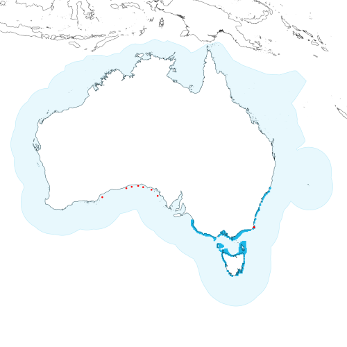
Modelled distribution shown as blue polygon (source: Australian National Fish Expert Distributions) Updated on 2008-11-19.
Occurrence locations [7] shown as red circles - View CSIRO Catch records Get expert distribution shapefile
View detailed map or click on map to see same.
Modelled distribution shown as blue polygon (source: Australian National Fish Expert Distributions) Updated on 2008-11-19.
Occurrence locations [7] shown as red circles - View CSIRO Catch records Get expert distribution shapefile
Catch records - 12 records found.
Click on survey to see survey details. Click on Operation to see full details of the catch. Use the CSV button at the bottom to export data.
| Date (UTC) | Position | Survey | Operation | Depth Range (m) | Count | Weight (kg) | Method | Effort | Gear |
|---|---|---|---|---|---|---|---|---|---|
| 1966-09-23 00:00 | 31° 45.0' S 130° 35.0' E | RADU196608 | 48 | 52 to 53 | 2 | Trawl | 105 minutes | ||
| 1966-12-27 00:00 | 33° 21.1' S 124° 34.1' E | RADU196608 | 283 | 50 to 50 | 3 | Trawl | 51 minutes | ||
| 1967-01-08 00:00 | 32° 05.1' S 128° 36.0' E | RADU196608 | 332 | 36 to 38 | Trawl | 60 minutes | |||
| 1970-09-15 00:00 | 31° 53.0' S 129° 30.1' E | ALBA197009 | 630 | 42 to 43 | 1 | Trawl | 60 minutes | ||
| 1971-07-24 00:00 | 32° 18.0' S 132° 49.0' E | POSE197107 | 245 | 63 to 65 | 1 | Trawl | 60 minutes | ||
| 1972-07-22 00:00 | 33° 10.0' S 133° 51.0' E | RADU197206 | 74 | 68 to 68 | 1 | Trawl | 60 minutes | ||
| 1973-10-21 00:00 | 31° 56.0' S 131° 25.0' E | ALBA197310 | 421 | 50 to 50 | 1 | 0.6 | Trawl | 55 minutes | |
| 1996-05-12 06:10 | 37° 27.4' S 149° 59.7' E | EJ199602 | 4 | Gillnet | |||||
| 1996-05-12 06:10 | 37° 27.4' S 149° 59.7' E | EJ199602 | 4 | Gillnet | |||||
| 1996-05-12 06:10 | 37° 27.4' S 149° 59.7' E | EJ199602 | 4 | Gillnet | |||||
| 1996-05-12 18:25 | 37° 29.1' S 149° 59.7' E | EJ199602 | 5 | Gillnet | |||||
| 1996-05-14 06:42 | 37° 27.2' S 149° 59.7' E | EJ199602 | 8 | Gillnet |