Voyage details and related metadata, reports, events and data.
SS2013_V03
- is a Marine National Facility ![]() voyage
voyage
Period: 2013-04-27 22:00 to 2013-05-09 22:00 UTC
Duration: 12.00 days
From: Hobart To: Hobart
Region: Southern Ocean-Indian sector. Subantarctic Zone southwest of Tasmania
Ship: Southern Surveyor [details]
Description: MNF Southern Surveyor research voyage SS2013_v03. Integrated Marine Observing System (IMOS) Facility 3. Southern Ocean Time Series (SOTS) moorings for climate and carbon cycle studies southwest of Tasmania (47ºS, 140ºE). Scientific Objectives The overall scientific objective is to obtain frequent measurements of surface and deep ocean properties that control the transfer of CO2 from the atmosphere to the upper ocean, and then onwards to the ocean interior in the form of sinking particles. This "biological pump" drives carbon sequestration from the atmosphere, and writes the sedimentary record. The controls on its intensity are complex and involve processes that vary on daily, weekly, seasonal, and inter-annual timescales. Obtaining observations with the necessary frequency is not possible from ships. For this reason the IMOS Southern Ocean Time Series Facility seeks to obtain this information using automated sensor measurements and sample collections. This voyage will carry out the annual servicing of SOTS moorings, along with a limited set of ancillary underway and on-station water column observations. The moorings to be deployed are: SOFS-4 mooring to make meteorological and upper ocean measurements of physical and chemical properties important to air-sea exchange of heat, water, momentum, and dissolved gases (oxygen and CO2). Pulse-10 mooring to make upper ocean measurements of properties that control carbon uptake and export to the ocean interior, including temperature, salinity, mixed layer depth, light, oxygen, total dissolved gases, phytoplankton fluorescence, particle backscatter, and dissolved nitrate, and collect 24 paired water samples later study of nutrients and phytoplankton identification. SAZ-16 mooring to collect sediment trap samples in the deep sea (below 1000m) to quantify the transfer of particulate carbon and other materials to the ocean interior. The moorings to be recovered are: Pulse-9 mooring SOFS-3 mooring (bottom half only - top recovered in 2012 after it broke loose) (SAZ-15 mooring will not be recovered, and will remain in the ocean until recovery in 2014) Ancillary measurements to be carried out include swath mapping, underway and CTD sensor and sample collections, zooplankton net sampling, towing of a continuous plankton recorder, launch of Argo floats, and a piggy-back project to calibrate ship acoustic sensors.
Leader: T. Trull (CMAR-UTAS-ACE)
Project: SOTS: Southern Ocean Time Series automated moorings for climate and carbon cycle studies southwest of Tasmania [details]
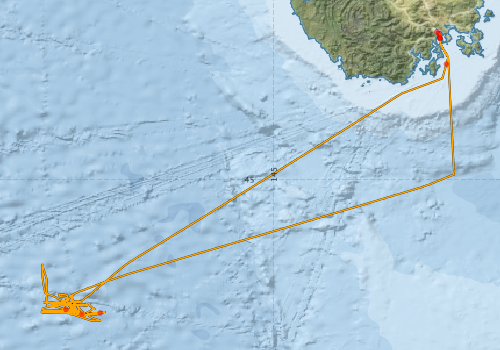
Voyage extents: 47° 01.6' S to 42° 53.1' S 141° 40.0' E to 147° 35.5' E Get voyage track shapefile Get CSV
Marlin Metadata:-
Participants - on ship:-
| Name | Role | Organisation |
|---|---|---|
| Chris Coxson | Sediment traps | Antarctic Cooperative Research Centre |
| Eric Schulz | Moorings, meteorology | Bureau of Meteorology |
| Hugh Barker | MNF Computing support | CSIRO Marine and Atmospheric Research |
| Jim LaDuke | Sediment traps | CSIRO Marine and Atmospheric Research |
| Lindsay MacDonald | MNF Electronics support | CSIRO Marine and Atmospheric Research |
| Mark Rayner | MNF Hydrochemistry Support | CSIRO Marine and Atmospheric Research |
| Mark Rosenberg | Moorings, CTD, glider, floats | Antarctic Cooperative Research Centre |
| Peter Jansen | Moorings, electronics | Antarctic Cooperative Research Centre |
| Rod Palmer | MNF Voyage Manager | CSIRO Marine and Atmospheric Research |
| Ryan Walker | Bio-acoutics | University of Western Australia |
| Shoichiro Baba | Mooring engineer | JAMSTEC / CMAR |
| Stephen Bray | Moorings, sediment traps | Antarctic Cooperative Research Centre |
| Tara Martin | MNF Swath mapping | CSIRO Marine and Atmospheric Research |
| Tom Trull | Chief Scientist | CMAR UTAS ACE |
This list includes those that may have only been on part of the voyage. See voyage reports on 'Reports and Maps' tab for details.
Marine National Facility Reports - plans, summaries and data processing
-
SS2013_V03 Scientific Highlight
- report of the key outputs
-
SS2013_V03 Underway Data Processing Report
- details of data processing steps, calibration information, instruments used and any issues with the data.
-
SS2013_V03 Voyage Summary
- includes preliminary results, voyage narrative, types of data collected with C77/ROSCOP codes.
-
SS2013_V03 Voyage Plan
- includes objectives, investigator details, proposed data collection, voyage track and equipment to be used.
-

Publications, reports and datasets from this voyage.
Dataset
- Bakker, Dorothee C E; Pfeil, Benjamin; Smith, Karl; Hankin, Steven; Olsen, Are; Alin, Simone R; Cosca, Catherine E; Harasawa, Sumiko; Kozyr, Alexander; Nojiri, Yukihiro; O'Brien, Kevin M; Schuster, Ute; Telszewski, Maciej; Tilbrook, Bronte; Wada, Chisato; Akl, John; Barbero, Leticia; Bates, Nicolas R; Boutin, Jacqueline; Bozec, Yann; Cai, Wei-Jun; Castle, Robert D; Chavez, Francisco P; Chen, Lei; Chierici, Melissa; Currie, Kim I; de Baar, Hein J W; Evans, Wiley; Feely, Richard A; Fransson, Agneta; Gao, Zhongyong; Hales, Burke; Hardman-Mountford, Nicolas J; Hoppema, Mario; Huang, Wei-Jen; Hunt, Christopher W; Huss, Betty; Ichikawa, Tadafumi; Johannessen, Truls; Jones, Elizabeth M; Jones, Steve D; Jutterstrøm, Sara; Kitidis, Vassilis; Körtzinger, Arne; Landschützer, Peter; Lauvset, Siv K; Lefèvre, Nathalie; Manke, Ansley; Mathis, Jeremy T; Merlivat, Liliane; Metzl, Nicolas; Murata, Akihiko; Newberger, Timothy; Omar, Abdirahman M; Ono, Tsuneo; Park, Geun-Ha; Paterson, Kristina; Pierrot, Denis; Ríos, Aida F; Sabine, Christopher L; Saito, Shu; Salisbury, Joe; Sarma, Vedula V S S; Schlitzer, Reiner; Sieger, Rainer; Skjelvan, Ingunn; Steinhoff, Tobias; Sullivan, Kevin; Sun, Heng; Sutton, Adrienne; Suzuki, Toru; Sweeney, Colm; Takahashi, Taro; Tjiputra, Jerry; Tsurushima, Nobuo; van Heuven, Steven; Vandemark, Doug; Vlahos, Penny; Wallace, Douglas WR; Wanninkhof, Rik; Watson, Andrew J (2014): Surface Ocean CO2 Atlas (SOCAT) V2. PANGAEA, 10.1594/PANGAEA.811776
- Smith, S. R.,Lopez, N.,Bourassa, M. A. (2016) SAMOS air‐sea fluxes: 2005–2014. Geoscience Data Journal 3 pp9-19. 10.1002/gdj3.34
Journal Article
- Shadwick, Elizabeth H.,Wynn-Edwards, Cathryn A.,Eriksen, Ruth S.,Jansen, Peter,Yang, Xiang,Woodward, Gemma,Davies, Diana (2025) The Southern Ocean Time Series: a climatological view of hydrography, biogeochemistry, phytoplankton community composition, and carbon export in the Subantarctic Zone. Ocean Science 21 pp1549-1573. 10.5194/os-21-1549-2025
- Traill, Christopher D.,Rohr, Tyler,Shadwick, Elizabeth,Schallenberg, Christina,Ellwood, Michael,Bowie, Andrew (2025) Coupling Between the Subantarctic Seasonal Iron Cycle and Productivity at the Southern Ocean Time Series (SOTS). AGU Advances 6 pp-. 10.1029/2024av001599
- Yang, X., Wynn-Edwards, C. A., Strutton, P. G., & Shadwick, E. H. (2024). (2024). Drivers of air-sea CO2 flux in the subantarctic zone revealed by time series observations. Global Biogeochemical Cycles 38: 18 10.1029/2023GB007766
- Yang, Xiang,Wynn‐Edwards, Cathryn A.,Strutton, Peter G.,Shadwick, Elizabeth H. (2024) Carbon Export in the Subantarctic Zone Revealed by Multi‐Year Observations From Biogeochemical‐Argo Floats and Sediment Traps. Global Biogeochemical Cycles 38 pp-. 10.1029/2024GB008135
Search for publications, reports and datasets from this and other voyages
Data publishing
This is a list of online datasets hosted by CSIRO. Other processed datasets hosted by collaborating organisations may be found on the 'Metadata' or "Reports, Publications and Maps' tab.
Use the Get data link on the right to extract data using the NCMI Data Trawler.
| Data Stream | Data Summary | Get data | ||||||||||||||
|---|---|---|---|---|---|---|---|---|---|---|---|---|---|---|---|---|
| ADCP Data |
|
Get Data from Trawler Download NetCDF ss2013_v03_ADCP_nc.zip Overview ADCP Dataset HTML Download Processing Report ss2013_v03ADCP.pdf |
||||||||||||||
| CTD profile |
|
Get Data from Trawler Download CTD plots ss2013_v03_CTD_plots_png.zip Processing report: :ss2013_v03_Processing_report.pdf Download CTD ss2013_v03_station_location_png.zip Download NetCDF data ss2013_v03_CTD_avg_nc.zip |
||||||||||||||
| Hydrology |
|
Get Data from Trawler Download CSV format - ss2013_v03_HYD_csv.zip Download Processing report Download NetCDF format - ss2013_v03_HYD_nc.zip |
||||||||||||||
| Multibeam echosounder |
|
Get Data from Trawler |
||||||||||||||
| SOOP Bio-acoustics |
|
External link
Transect 2 - datafile at IMOS NetCDF Data Format: Manual Download |
||||||||||||||
| Underway |
|
Get Data from Trawler Download 5 sec NetCDF dataset ss2013_v03UWYnc.zip |
| ID | When (UTC) | Lat | Long | Instrument | Identifier | Action | Log | Subject / Comment |
|---|
Deployments by start time:- Click on column header to sort. Use link on 'Deployment' to see full details. Use the CSV button at the bottom to export data (tab delimited).
Search for deployments from this voyage and others
| Deployment | Operation | Station | Cast | Gear | Project | Start and end times | Start Location | End Location | Depth range | Max Depth | Description | |||
|---|---|---|---|---|---|---|---|---|---|---|---|---|---|---|
| ADCP Data [details] | RDI Ocean Surveyor Acoustic Doppler current profiler | 2365 | 2013-04-27 21:37 | 2013-05-09 15:58 | -42.9081 | 147.3708 | -43.2212 | 147.4831 | 653.5 | |||||
| Underway System [details] | Air Temperature Sensor-HMT333,Barometer,Doppler speed log,Fluorometer WS3S-443P,Gill Ultrasonic Wind Sensor,Gill Ultrasonic Wind Sensor,Humidity Sensor-HMT333,IMOS Port Pyranometer-SN 35122F3,IMOS Port Radiometer-SN 35111F3,IMOS Stbd Pyranometer-SN 35123F3,IMOS Stbd Radiometer-SN 35093F3,IMOS rain gauge,IMOS rain gauge,Licor - LI-190SL Q46072,RM Young 05106 wind monitor-75621,RM Young 05106 wind monitor-75621,RM Young 05106 wind monitor-75621,RM Young Rain Gauge,Seapath 200,Seapath 200,Seapath 200,Simrad EK60 echosounder,ThermoSalinoGraph (TSG)-SN 2753,ThermoSalinoGraph (TSG)-SN 2753 | 2365 | 2013-04-27 22:13 | 2013-05-09 22:06 | -42.8863 | 147.3385 | ||||||||
| CTD Cast / Hydrology [details] | 1 | Cast 1 | CTD 21,Conductivity CTD 21 - SN 3309,Fluorometer-CTD21-Chelsea-11-8206-001,Licor - CTD 21 - SN 70111,Oxygen CTD 21-SBE 43-SN 1794,Pressure CTD 21,Temperature CTD 21 - SN 5422,Transmissometer - CTD 21 -CST-1519DR | 2365 | 2013-04-28 05:33 | 2013-04-28 05:38 | -42.9718 | 147.3813 | 25.5 | |||||
| CTD Cast / Hydrology [details] | 2 | Cast 2 | CTD 21,Conductivity CTD 21 - SN 3309,Fluorometer-CTD21-Chelsea-11-8206-001,Licor - CTD 21 - SN 70111,Oxygen CTD 21-SBE 43-SN 1794,Pressure CTD 21,Temperature CTD 21 - SN 5422,Transmissometer - CTD 21 -CST-1519DR | 2365 | 2013-04-28 08:37 | 2013-04-28 08:40 | -42.9713 | 147.3805 | 22 | |||||
| CTD Cast / Hydrology [details] | 3 | Cast 3 | CTD 21,Conductivity CTD 21 - SN 3309,Fluorometer-CTD21-Chelsea-11-8206-001,Licor - CTD 21 - SN 70111,Oxygen CTD 21-SBE 43-SN 1794,Pressure CTD 21,Temperature CTD 21 - SN 5422,Transmissometer - CTD 21 -CST-1519DR | 2365 | 2013-04-28 10:00 | 2013-04-28 10:06 | -42.9719 | 147.3805 | -42.9723 | 147.3802 | 20.7 | |||
| Multibeam echosounder [details] | EM300 Multibeam Echosounder | 2013-04-29 00:47 | 2013-05-09 16:36 | -43.3456 | 147.4735 | -43.2192 | 147.4834 | 5868.6 | ||||||
| CTD Cast / Hydrology [details] | 4 | Cast 4 | CTD 21,Conductivity CTD 21 - SN 3309,Fluorometer-CTD21-Chelsea-11-8206-001,Licor - CTD 21 - SN 70111,Oxygen CTD 21-SBE 43-SN 1794,Pressure CTD 21,Temperature CTD 21 - SN 5422,Transmissometer - CTD 21 -CST-1519DR | 2365 | 2013-05-02 00:10 | 2013-05-02 01:09 | -46.8616 | 142.0196 | -46.8652 | 142.0280 | 998.2 | |||
| CTD Cast / Hydrology [details] | 6 | Cast 6 | CTD 21,Conductivity CTD 21 - SN 3309,Fluorometer-CTD21-Chelsea-11-8206-001,Licor - CTD 21 - SN 70111,Oxygen CTD 21-SBE 43-SN 1794,Pressure CTD 21,Temperature CTD 21 - SN 5422,Transmissometer - CTD 21 -CST-1519DR | 2365 | 2013-05-02 03:35 | 2013-05-02 04:39 | -46.9336 | 142.2474 | -46.9339 | 142.2611 | 998.5 | |||
| CTD Cast / Hydrology [details] | 7 | Cast 7 | CTD 21,Conductivity CTD 21 - SN 3309,Fluorometer-CTD21-Chelsea-11-8206-001,Licor - CTD 21 - SN 70111,Oxygen CTD 21-SBE 43-SN 1794,Pressure CTD 21,Temperature CTD 21 - SN 5422,Transmissometer - CTD 21 -CST-1519DR | 2365 | 2013-05-02 06:23 | 2013-05-02 07:05 | -46.9133 | 142.5094 | -46.9180 | 142.5073 | 1001 | |||