Voyage details and related metadata, reports, events and data.
SS2012_T02
- is a Marine National Facility ![]() voyage
voyage
Period: 2012-05-02 03:00 to 2012-05-09 22:00 UTC
Duration: 7.79 days
From: Brisbane To: Lautoka
Region: Great Barrier Reef, Gardner Bank, and South Pacific Ocean
Ship: Southern Surveyor [details]
Description: MNF Southern Surveyor RV ss2012_t02. Great Barrier Reef phase shift: Gardner Banks to Gardner Reef. Scientific Objectives: On a global scale, coral reefs are experiencing a period of rapid change. The world has effectively lost 19% of the original area of coral reefs since 1950, with the loss predicted of 35% of coral reefs in the next 40 years (Wilkinson, 2008). About 46% of coral reefs are regarded as healthy except for currently unpredictable global climate threats, which includes the Great Barrier Reef (GBR). The observed shift of average marine climate zones south by >200 km since 1950 (Lough, 2008) could potentially result in the GBR extending south, causing an algal to coral phase shift as coral settlement follows the changing environmental gradient. The shelf adjacent to Fraser Island is located at the transition between tropical carbonates (GBR) to the north and cool-water carbonates to the south (Schröder-Adams et al., 2008) and represents an ideal natural laboratory to investigate this phase shift. The projected warming trend in SST would anticipate a phase shift from a red algal-dominated substrate to a coral-dominated substrate. A hypothesis is that Gardner Bank would form an antecedent surface for future coral reef development through net coral framework accretion. In effect, Gardner Bank would become Gardner Reef, therefore it is crucial that the extent, structure and morphology of this potentially important site be investigated. (Part extract from voyage plan, please see plan for full details.)
Leader: R. Beaman (JCU), J. Webster (USYD)
Project: National Facility External Users: R. Beaman (JCU) [details]
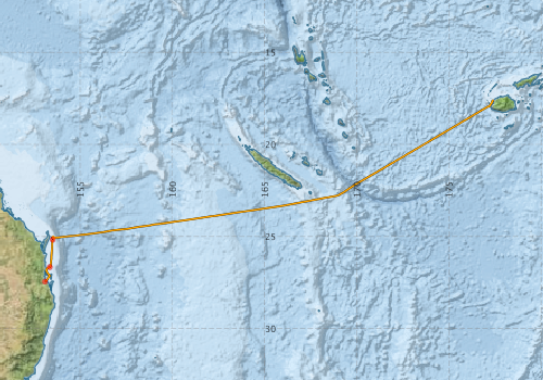
Voyage extents: 27° 26.9' S to 17° 36.1' S 153° 04.6' E to 177° 25.6' E Get voyage track shapefile Get CSV
Marlin Metadata:-
Metadata from OBIS Australia datasets:- biological data is published via the OBIS-AU IPT server and delivered to one or more of OBIS, ALA and GBIF
Download from OBIS Australia IPT View at - Ocean Biodiversity Information System (OBIS) Atlas of Living Australia (ALA) GBIF
Download from OBIS Australia IPT View at - Ocean Biodiversity Information System (OBIS) Atlas of Living Australia (ALA) GBIF
Participants - on ship:-
| Name | Role | Organisation |
|---|---|---|
| Adrian Eddy | Scientist | AHS |
| Alan Poole | XBT technician | CSIRO Oceans & Atmosphere - Hobart |
| Christopher Caldow | Scientist | University of Wollongong |
| Dagmar Kubistin | Scientist | University of Wollongong |
| Don McKenzie | MNF Voyage manager | CSIRO Marine and Atmospheric Research |
| Gustavo Hinestrosa | Scientist | University of Sydney |
| Hugh Barker | MNF Computing Support | CSIRO Marine and Atmospheric Research |
| Jody Webster | University of Sydney | |
| Julia Reisser | Marine Debris | CSIRO UWA |
| Lindsay MacDonald | MNF Electronics support | CSIRO Marine and Atmospheric Research |
| Murphy Birnberg | Scientist | James Cook University |
| Rob Beaman | Principal Investigator | James Cook University - Department of Marine Biology |
| Sascha Frydman | MNF EM300 swath technician | CSIRO Oceans & Atmosphere - Hobart |
| Tara Martin | MNF EM300 swath technician | CSIRO Oceans & Atmosphere - Hobart |
This list includes those that may have only been on part of the voyage. See voyage reports on 'Reports and Maps' tab for details.
Marine National Facility Reports - plans, summaries and data processing
-
SS2012_T02 Scientific Highlight
- report of the key outputs
-
SS2012_T02 Underway Data Processing Report
- details of data processing steps, calibration information, instruments used and any issues with the data.
-
SS2012_T02 Voyage Summary
- includes preliminary results, voyage narrative, types of data collected with C77/ROSCOP codes.
-
SS2012_T02 Voyage Plan
- includes objectives, investigator details, proposed data collection, voyage track and equipment to be used.
-

Publications, reports and datasets from this voyage.
Dataset
- Bakker, Dorothee C E; Pfeil, Benjamin; Smith, Karl; Hankin, Steven; Olsen, Are; Alin, Simone R; Cosca, Catherine E; Harasawa, Sumiko; Kozyr, Alexander; Nojiri, Yukihiro; O'Brien, Kevin M; Schuster, Ute; Telszewski, Maciej; Tilbrook, Bronte; Wada, Chisato; Akl, John; Barbero, Leticia; Bates, Nicolas R; Boutin, Jacqueline; Bozec, Yann; Cai, Wei-Jun; Castle, Robert D; Chavez, Francisco P; Chen, Lei; Chierici, Melissa; Currie, Kim I; de Baar, Hein J W; Evans, Wiley; Feely, Richard A; Fransson, Agneta; Gao, Zhongyong; Hales, Burke; Hardman-Mountford, Nicolas J; Hoppema, Mario; Huang, Wei-Jen; Hunt, Christopher W; Huss, Betty; Ichikawa, Tadafumi; Johannessen, Truls; Jones, Elizabeth M; Jones, Steve D; Jutterstrøm, Sara; Kitidis, Vassilis; Körtzinger, Arne; Landschützer, Peter; Lauvset, Siv K; Lefèvre, Nathalie; Manke, Ansley; Mathis, Jeremy T; Merlivat, Liliane; Metzl, Nicolas; Murata, Akihiko; Newberger, Timothy; Omar, Abdirahman M; Ono, Tsuneo; Park, Geun-Ha; Paterson, Kristina; Pierrot, Denis; Ríos, Aida F; Sabine, Christopher L; Saito, Shu; Salisbury, Joe; Sarma, Vedula V S S; Schlitzer, Reiner; Sieger, Rainer; Skjelvan, Ingunn; Steinhoff, Tobias; Sullivan, Kevin; Sun, Heng; Sutton, Adrienne; Suzuki, Toru; Sweeney, Colm; Takahashi, Taro; Tjiputra, Jerry; Tsurushima, Nobuo; van Heuven, Steven; Vandemark, Doug; Vlahos, Penny; Wallace, Douglas WR; Wanninkhof, Rik; Watson, Andrew J (2014): Surface Ocean CO2 Atlas (SOCAT) V2. PANGAEA, 10.1594/PANGAEA.811776
- Raes, Eric J; Clementson, Lesley; Strutton, Pete; Waite, Anya M (2017): Photosynthetic pigment data from the Southeast Indian Ocean (2012-2013). PANGAEA 10.1594/PANGAEA.883906
- Smith, S. R.,Lopez, N.,Bourassa, M. A. (2016) SAMOS air‐sea fluxes: 2005–2014. Geoscience Data Journal 3 pp9-19. 10.1002/gdj3.34
IPT Resource
- IMOS - Phytoplankton Abundance and Biovolume (CPR), Australia (2007 to present) (Darwin Core Archive) External link to reference
- IMOS - Zooplankton Abundance and Biomass Index (CPR) (Darwin Core Archive) External link to reference
Journal Article
- Bukosa, Beata,Deutscher, Nicholas M.,Fisher, Jenny A.,Kubistin, Dagmar,Paton-Walsh, Clare,Griffith, David W. T. (2019) Simultaneous shipborne measurements of CO2, CH4 and CO and their application to improving greenhouse-gas flux estimates in Australia. Atmospheric Chemistry and Physics 19 pp7055-7072. 10.5194/acp-19-7055-2019
- McEnnulty, Felicity R.,Davies, Claire H.,Armstrong, Asia O,Atkins, Natalia,Coman, Frank,Clementson, Lesley,Edgar, Steven,Eriksen, Ruth S.,Everett, Jason D.,Anthony Koslow, J.,Lønborg, Christian,McKinnon, A. David,Miller, Margaret,O’Brien, Todd D.,Pausina, Sarah A.,Uribe-Palomino, Julian,Rochester, Wayne,Rothlisberg, Peter C.,Slotwinski, Anita,Strzelecki, Joanna (2020) A database of zooplankton biomass in Australian marine waters. Scientific Data 7 pp-. 10.1038/s41597-020-00625-9
Search for publications, reports and datasets from this and other voyages
Data publishing
This is a list of online datasets hosted by CSIRO. Other processed datasets hosted by collaborating organisations may be found on the 'Metadata' or "Reports, Publications and Maps' tab.
Use the Get data link on the right to extract data using the NCMI Data Trawler.
| Data Stream | Data Summary | Get data | ||||||||||||||
|---|---|---|---|---|---|---|---|---|---|---|---|---|---|---|---|---|
| ADCP Data |
|
Get Data from Trawler Download NetCDFss2012_t02_ADCP_long_nc.zip Download Processing Report ss2012_t02ADCP.pdf Download NetCDFss2012_t02_ADCP_short_nc.zip Overview ADCP Dataset HTML |
||||||||||||||
| Marine biodiversity observations and/or samples |
|
Get Data from Trawler |
||||||||||||||
| CPR |
|
External link - Get CPR Data from IMOS in CSV format |
||||||||||||||
| CTD profile |
|
Get Data from Trawler Download NetCDF data ss2012_t02_CTD_avg_not_calibrated_nc.zip Downlaod ss2012_t02CTD.txt |
||||||||||||||
| Multibeam echosounder |
|
Get Data from Trawler |
||||||||||||||
| pCO2 |
|
External link - download datafile at IMOS |
||||||||||||||
| SOOP Bio-acoustics |
|
External link - datafile at IMOS NetCDF Data Format: Manual Download |
||||||||||||||
| Underway |
|
Get Data from Trawler Download 5 sec NetCDF dataset ss2012_t02UWYnc.zip |
||||||||||||||
| XBT Profile | No data |
Deployments by start time:- Click on column header to sort. Use link on 'Deployment' to see full details. Use the CSV button at the bottom to export data (tab delimited).
Search for deployments from this voyage and others
| Deployment | Operation | Station | Cast | Gear | Project | Start and end times | Start Location | End Location | Depth range | Max Depth | Description | |||
|---|---|---|---|---|---|---|---|---|---|---|---|---|---|---|
| Underway System [details] | Air Temperature Sensor-HMT333,Barometer,Doppler speed log,Fluorometer WS3S-443P,Gill Ultrasonic Wind Sensor,Gill Ultrasonic Wind Sensor,Humidity Sensor-HMT333,IMOS Port Pyranometer-SN 35122F3,IMOS Port Radiometer-SN 35111F3,IMOS Stbd Pyranometer-SN 35123F3,IMOS Stbd Radiometer-SN 35093F3,IMOS rain gauge,IMOS rain gauge,Licor-UWQ 3708,RM Young 05106 wind monitor-SN 82705,RM Young 05106 wind monitor-SN 82705,RM Young 05106 wind monitor-SN 82705,RM Young Rain Gauge,Remote Temperature (T)-SN 2621,Seapath 200,Seapath 200,Seapath 200,Simrad EK60 echosounder,ThermoSalinoGraph (TSG)-SS-SN 1777 | 2392 | 2012-05-02 03:01 | 2012-05-09 22:14 | -27.4464 | 153.0762 | -17.6004 | 177.4363 | ||||||
| CTD Cast [details] | 1 | Cast 1 | CTD 21,Conductivity CTD 21-SN 2312,Pressure CTD 21,Temperature CTD 21 - SN 4718 | 2392 | 2012-05-02 19:11 | 2012-05-02 19:15 | -25.1726 | 153.5021 | -25.1730 | 153.5010 | 48 | |||
| ADCP Data [details] | RDI Ocean Surveyor Acoustic Doppler current profiler | 2392 | 2012-05-03 08:56 | 2012-05-10 18:35 | -26.6611 | 153.3416 | -17.9261 | 177.2201 | 652.9 | |||||
| Multibeam echosounder [details] | EM300 Multibeam Echosounder | |||||||||||||