Voyage details and related metadata, reports, events and data.
SS2011_V05
- is a Marine National Facility ![]() voyage
voyage
Period: 2011-09-21 07:00 to 2011-10-18 22:00 UTC
Duration: 27.63 days
From: Geraldton To: Fremantle
Region: Offshore north Perth Basin, WA coast
Ship: Southern Surveyor [details]
Description: Southern Surveyor Research Voyage ss2011_v05. The influence of natural hydrocarbon migration and seepage on the geological and biological systems of the offshore northern Perth Basin. Scientific Objectives 1. Map sites of natural hydrocarbon seepage in the offshore northern Perth Basin (Jones,Kennard, Ross, Greinert) On the basis of: acoustic signatures in the water column, shallow subsurface and on the seabed; geochemical signatures in rock and sediment samples and the water column, and; biological signatures on the seabed: document the spatial distribution of seepage sites and characterise the nature of the seepage at these sites (gas vs oil, macroseepage vs microseepage; palaeo vs modern day seepage). 2. Investigate generic structural controls on natural hydrocarbon seepage in the offshore northern Perth Basin, to determine the leaking versus sealing nature of individual faults within linked fault systems (Jones, Kennard). Quantify seepage indicators over sealing structures through surveying the seabed over known oil and gas accumulations, then compare and contrast the results with indicators of seepage over structures with residual hydrocarbon columns that are known to have leaked or be leaking, then use these controls to assess the leaking or sealing nature of other structures in a variety of environments. 3. Assess the influence and potential future impact of natural hydrocarbon seepage on geological and biological systems and anthropogenic activities in Australias southwest margin (Jones, Heap, Greinert). Determine whether the level of natural hydrocarbon seepage within the offshore northern Perth Basin: a) is likely to impact climate change due to methane release in shallow water, b) is a control on benthic habitat distribution, c) presents a natural hazard such as for drilling or slope stability, or d) has the potential to change or influence petroleum prospectivity.
Leader: A. Jones (Geoscience Australia)
Project: National Facility External Users: A. Jones (Geoscience Australia ) [details]
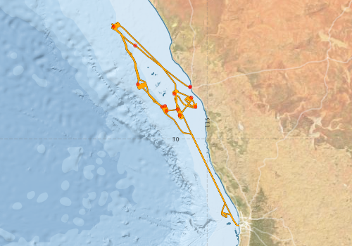
Voyage extents: 32° 03.4' S to 27° 13.9' S 112° 44.3' E to 115° 45.1' E Get voyage track shapefile Get CSV
Marlin Metadata:-
Participants - on ship:-
| Name | Role | Organisation |
|---|---|---|
| Andrew Jones | Chief Scientist | Geoscience Australia |
| Andrew Ross | Scientist | CSIRO Petroleum |
| Cameron Mitchell | Shift Leader | Geoscience Australia |
| Charlotte Stalvies | Scientist | CSIRO Petroleum |
| Chris Nicholson | Scientist | Geoscience Australia |
| Craig Wintle | Mechanical Technician | Geoscience Australia |
| Emma Crooke | Scientist | CSIRO Petroleum |
| Lynda Radke | Scientist | Geoscience Australia |
| Matthew Carey | Science Technician | Geoscience Australia |
| Olivia Wilson | Swath processor | Geoscience Australia |
| Pamela Brodie | MNF Computing Support | CSIRO Oceans & Atmosphere - Hobart |
| Peter Dunn | MNF Electronics Support | CSIRO Oceans & Atmosphere - Hobart |
| Stephen Hodgkin | Electronics tech | Geoscience Australia |
| Stephen McCullum | MNF Voyage Manager | CSIRO Oceans & Atmosphere - Hobart |
| Tara Martin | MNF Swath Support | CSIRO Oceans & Atmosphere - Hobart |
This list includes those that may have only been on part of the voyage. See voyage reports on 'Reports and Maps' tab for details.
Marine National Facility Reports - plans, summaries and data processing
-
SS2011_V05 Scientific Highlight
- report of the key outputs
-
SS2011_V05 Underway Data Processing Report
- details of data processing steps, calibration information, instruments used and any issues with the data.
-
SS2011_V05 Voyage Summary
- includes preliminary results, voyage narrative, types of data collected with C77/ROSCOP codes.
-
SS2011_V05 Voyage Plan
- includes objectives, investigator details, proposed data collection, voyage track and equipment to be used.
-

Publications, reports and datasets from this voyage.
Dataset
- Bakker, Dorothee C E; Pfeil, Benjamin; Smith, Karl; Hankin, Steven; Olsen, Are; Alin, Simone R; Cosca, Catherine E; Harasawa, Sumiko; Kozyr, Alexander; Nojiri, Yukihiro; O'Brien, Kevin M; Schuster, Ute; Telszewski, Maciej; Tilbrook, Bronte; Wada, Chisato; Akl, John; Barbero, Leticia; Bates, Nicolas R; Boutin, Jacqueline; Bozec, Yann; Cai, Wei-Jun; Castle, Robert D; Chavez, Francisco P; Chen, Lei; Chierici, Melissa; Currie, Kim I; de Baar, Hein J W; Evans, Wiley; Feely, Richard A; Fransson, Agneta; Gao, Zhongyong; Hales, Burke; Hardman-Mountford, Nicolas J; Hoppema, Mario; Huang, Wei-Jen; Hunt, Christopher W; Huss, Betty; Ichikawa, Tadafumi; Johannessen, Truls; Jones, Elizabeth M; Jones, Steve D; Jutterstrøm, Sara; Kitidis, Vassilis; Körtzinger, Arne; Landschützer, Peter; Lauvset, Siv K; Lefèvre, Nathalie; Manke, Ansley; Mathis, Jeremy T; Merlivat, Liliane; Metzl, Nicolas; Murata, Akihiko; Newberger, Timothy; Omar, Abdirahman M; Ono, Tsuneo; Park, Geun-Ha; Paterson, Kristina; Pierrot, Denis; Ríos, Aida F; Sabine, Christopher L; Saito, Shu; Salisbury, Joe; Sarma, Vedula V S S; Schlitzer, Reiner; Sieger, Rainer; Skjelvan, Ingunn; Steinhoff, Tobias; Sullivan, Kevin; Sun, Heng; Sutton, Adrienne; Suzuki, Toru; Sweeney, Colm; Takahashi, Taro; Tjiputra, Jerry; Tsurushima, Nobuo; van Heuven, Steven; Vandemark, Doug; Vlahos, Penny; Wallace, Douglas WR; Wanninkhof, Rik; Watson, Andrew J (2014): Surface Ocean CO2 Atlas (SOCAT) V2. PANGAEA, 10.1594/PANGAEA.811776
- Jones, A., Wilson, O. (2012) North Perth Basin Bathymetry Survey (SS2011_v05/GA-0332). Geoscience Australia, Canberra. 10.4225/25/53D9B0F06A6FA
- Smith, S. R.,Lopez, N.,Bourassa, M. A. (2016) SAMOS air‐sea fluxes: 2005–2014. Geoscience Data Journal 3 pp9-19. 10.1002/gdj3.34
Journal Article
- Lucieer, Vanessa,Flukes, Emma,Monk, Jacquomo,Walsh, Peter (2024) Geomorphometric maps of Australia’s Marine Park estate and their role in improving the integrated monitoring and management of marine ecosystems. Frontiers in Marine Science 10 pp-. 10.3389/fmars.2023.1302108
- Radke, Lynda,Nicholas, Tony,Thompson, Peter A.,Li, Jin,Raes, Eric (2017) Baseline biogeochemical data from Australia's continental margin links seabed sediments to water column characteristics. Marine and Freshwater Research 68 pp1593-. 10.1071/MF16219
Search for publications, reports and datasets from this and other voyages
Data publishing
This is a list of online datasets hosted by CSIRO. Other processed datasets hosted by collaborating organisations may be found on the 'Metadata' or "Reports, Publications and Maps' tab.
Use the Get data link on the right to extract data using the NCMI Data Trawler.
| Data Stream | Data Summary | Get data | ||||||||||||||
|---|---|---|---|---|---|---|---|---|---|---|---|---|---|---|---|---|
| ADCP Data |
|
Get Data from Trawler Download NetCDF ss2011_v05_ADCP_nc.zip Overview ADCP Dataset HTML Download Processing Report ss2011_v05ADCP.pdf |
||||||||||||||
| CTD profile |
|
Get Data from Trawler Download NetCDF data ss2011_v05_ctd_avg_nc.zip Processing report: ss2011_v05ctdReport.pdf Download Avg CTD plots ss2011_v05_ctd_plots_eps.zip |
||||||||||||||
| Multibeam echosounder |
|
Get Data from Trawler |
||||||||||||||
| Underway |
|
Get Data from Trawler Download 5 sec NetCDF dataset ss2011_v05UWYnc.zip |
Deployments by start time:- Click on column header to sort. Use link on 'Deployment' to see full details. Use the CSV button at the bottom to export data (tab delimited).
Search for deployments from this voyage and others
| Deployment | Operation | Station | Cast | Gear | Project | Start and end times | Start Location | End Location | Depth range | Max Depth | Description | |||
|---|---|---|---|---|---|---|---|---|---|---|---|---|---|---|
| Underway System [details] | Air Temperature Sensor-HMT333,Barometer,Doppler speed log,Fluorometer WS3S-1203,Gill Ultrasonic Wind Sensor,Gill Ultrasonic Wind Sensor,Humidity Sensor-HMT333,IMOS Port Pyranometer-SN 35122F3,IMOS Port Radiometer-SN 35111F3,IMOS Stbd Pyranometer-SN 35123F3,IMOS Stbd Radiometer-SN 35093F3,IMOS rain gauge,IMOS rain gauge,Licor-UWQ 3708,RM Young 05106 wind monitor-SN 82705,RM Young 05106 wind monitor-SN 82705,RM Young 05106 wind monitor-SN 82705,RM Young Rain Gauge,Seapath 200,Seapath 200,Seapath 200,Simrad EK60 echosounder,ThermoSalinoGraph (TSG)-SN 2567,ThermoSalinoGraph (TSG)-SN 2567 | 2387 | 2011-09-21 07:02 | 2011-10-17 23:02 | -28.7729 | 114.5947 | -32.0500 | 115.7448 | ||||||
| Multibeam echosounder [details] | EM300 Multibeam Echosounder | 2011-09-21 07:19 | 2011-10-17 22:58 | -28.7576 | 114.5984 | -32.0500 | 115.7447 | 1729.9 | ||||||
| ADCP Data [details] | RDI Ocean Surveyor Acoustic Doppler current profiler | 2387 | 2011-09-21 15:52 | 2011-10-02 08:17 | -27.7831 | 113.2926 | -31.1455 | 115.2384 | 813 | |||||
| CTD Cast [details] | 2 | Cast 2 | CTD 21,Conductivity CTD 21-SN 3169,Fluorometer-CTD 21 -Chelsea-06-5941-001,Licor - CTD 21 - SN 70111,Pressure CTD 21,Temperature CTD 21 - SN 4718,Transmissometer - CTD 21 -CST-1016DR | 2387 | 2011-09-22 21:53 | 2011-09-22 22:22 | -27.3331 | 112.7815 | -27.3247 | 112.7872 | 461 | |||
| CTD Cast [details] | 3 | Cast 3 | CTD 21,Conductivity CTD 21-SN 3169,Fluorometer-CTD 21 -Chelsea-06-5941-001,Licor - CTD 21 - SN 70111,Pressure CTD 21,Temperature CTD 21 - SN 4718,Transmissometer - CTD 21 -CST-1016DR | 2387 | 2011-09-23 09:33 | 2011-09-23 10:12 | -28.6997 | 113.3542 | -28.6987 | 113.3567 | 960 | |||
| CTD Cast [details] | 4 | Cast 4 | CTD 21,Conductivity CTD 21-SN 3169,Fluorometer-CTD 21 -Chelsea-06-5941-001,Licor - CTD 21 - SN 70111,Pressure CTD 21,Temperature CTD 21 - SN 4718,Transmissometer - CTD 21 -CST-1016DR | 2387 | 2011-09-24 17:35 | 2011-09-24 17:50 | -29.2373 | 113.9292 | -29.2375 | 113.9306 | 340 | |||
| CTD Cast [details] | 5 | Cast 5 | CTD 21,Conductivity CTD 21-SN 3169,Fluorometer-CTD 21 -Chelsea-06-5941-001,Licor - CTD 21 - SN 70111,Pressure CTD 21,Temperature CTD 21 - SN 4718,Transmissometer - CTD 21 -CST-1016DR | 2387 | 2011-09-25 18:32 | 2011-09-25 18:44 | -29.2172 | 113.9993 | -29.2175 | 113.9997 | 159 | |||
| CTD Cast [details] | 6 | Cast 6 | CTD 21,Conductivity CTD 21-SN 3169,Fluorometer-CTD 21 -Chelsea-06-5941-001,Licor - CTD 21 - SN 70111,Pressure CTD 21,Temperature CTD 21 - SN 4718,Transmissometer - CTD 21 -CST-1016DR | 2387 | 2011-09-25 20:28 | 2011-09-25 20:46 | -29.3317 | 114.0342 | -29.3322 | 114.0341 | 223 | |||
| CTD Cast [details] | 7 | Cast 7 | CTD 21,Conductivity CTD 21-SN 3169,Fluorometer-CTD 21 -Chelsea-06-5941-001,Licor - CTD 21 - SN 70111,Pressure CTD 21,Temperature CTD 21 - SN 4718,Transmissometer - CTD 21 -CST-1016DR | 2387 | 2011-09-25 22:36 | 2011-09-25 22:40 | -29.2993 | 114.2979 | -29.2990 | 114.2976 | 52 | |||
| CTD Cast [details] | 8 | Cast 8 | CTD 21,Conductivity CTD 21-SN 3169,Fluorometer-CTD 21 -Chelsea-06-5941-001,Licor - CTD 21 - SN 70111,Pressure CTD 21,Temperature CTD 21 - SN 4718,Transmissometer - CTD 21 -CST-1016DR | 2387 | 2011-09-27 21:27 | 2011-09-27 21:38 | -29.4353 | 114.3472 | -29.4345 | 114.3478 | 55 | |||
| CTD Cast [details] | 9 | Cast 9 | CTD 21,Conductivity CTD 21-SN 3169,Fluorometer-CTD 21 -Chelsea-06-5941-001,Licor - CTD 21 - SN 70111,Pressure CTD 21,Temperature CTD 21 - SN 4718,Transmissometer - CTD 21 -CST-1016DR | 2387 | 2011-09-28 21:37 | 2011-09-28 21:40 | -29.0201 | 114.6224 | -29.0198 | 114.6224 | 29 | |||
| CTD Cast [details] | 10 | Cast 10 | CTD 21,Conductivity CTD 21-SN 3169,Fluorometer-CTD 21 -Chelsea-06-5941-001,Licor - CTD 21 - SN 70111,Pressure CTD 21,Temperature CTD 21 - SN 4718,Transmissometer - CTD 21 -CST-1016DR | 2387 | 2011-09-29 01:17 | 2011-09-29 01:22 | -29.2366 | 114.7184 | -29.2361 | 114.7186 | 32 | |||
| CTD Cast [details] | 11 | Cast 11 | CTD 21,Conductivity CTD 21-SN 3169,Fluorometer-CTD 21 -Chelsea-06-5941-001,Licor - CTD 21 - SN 70111,Pressure CTD 21,Temperature CTD 21 - SN 4718,Transmissometer - CTD 21 -CST-1016DR | 2387 | 2011-09-30 06:04 | 2011-09-30 06:18 | -28.9277 | 114.2183 | -28.9285 | 114.2189 | 45 | |||