Voyage details and related metadata, reports, events and data.
SS2011_T04
- is a Marine National Facility ![]() voyage
voyage
Period: 2011-11-10 08:00 to 2011-11-20 02:00 UTC
Duration: 9.75 days
From: Fremantle To: Hobart
Region: Western Australia Coast South, South Australia Coast, Tasmania Coast West.
Ship: Southern Surveyor [details]
Description: Southern Surveyor SS2011_T04. 2,000 years of oceanic history offshore southern Australia in combination with National upper slope seabed multi-beam mapping and ecological interpretation Scientific Objectives: Project 1: PI: Prof. Patrick De Deckker This project will generate high-resolution records of sea-surface temperature [SST] changes that have occurred offshore southern Australlia over the last two millennia. A variety of innovative proxies will be employed and used for comparison with lake records on land. International collaboration is a feature of this program, linking with the Royal Netherlands Institute for Sea Research [NIOZ] to determine past sea-surface temperatures and wind-induced upwelling conditions using specific organic compounds recovered in deep-sea cores, and with the marine radio-isotope laboratory in Bordeaux, France, to accurately date cores over short time scales. Project 2: PI: Dr Rudy Kloser Spatial management is becoming increasingly common and Australia leads the world in developing a National Representative System of Marine Protected Areas (NRSMPA) by 2012. However, the NRSMPA by itself will not be adequate to manage and protect the marine environment and spatial management of areas outside the NRSMPA will be required. This places an increased demand on scientists to know the physical structure of those areas and their value to biodiversity and ecosystem function. Extracted from Voyage plan please read plan for full description.
Leader: P. de Deckker (ANU)
Project: National Facility External Users: P. De Deckker (ANU) [details]
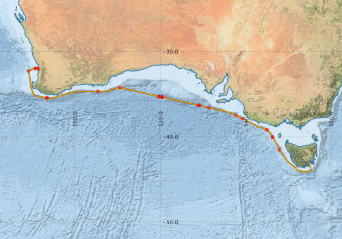
Voyage extents: 44° 09.0' S to 31° 56.7' S 114° 31.4' E to 147° 37.6' E Get voyage track shapefile Get CSV
Marlin Metadata:-
Metadata from OBIS Australia datasets:- biological data is published via the OBIS-AU IPT server and delivered to one or more of OBIS, ALA and GBIF
Download from OBIS Australia IPT View at - Ocean Biodiversity Information System (OBIS) Atlas of Living Australia (ALA) GBIF
Download from OBIS Australia IPT View at - Ocean Biodiversity Information System (OBIS) Atlas of Living Australia (ALA) GBIF
Participants - on ship:-
| Name | Role | Organisation |
|---|---|---|
| Alicia Navidad | MNF Hydrochemistry Support | CSIRO Oceans & Atmosphere - Hobart |
| Ashley Burkett | To operate the multicorer and subsample the cores for their microbiota | Indiana State University |
| Chris Munday | In charge of the aerosol samplers and help with the multicorer. | Australian National University |
| Graham Nash | To operate the multicorer | Australian National University |
| Lindsay MacDonald | MNF Electronics support | CSIRO Oceans & Atmosphere - Hobart |
| Lindsay Pender | MNF Voyage manager/Computing support | CSIRO Oceans & Atmosphere - Hobart |
| Lyndsay Dean | Help with the CTD and water sampling for a variety of purposes as well as filer waters for nanoplankton analysis | Australian National University |
| Marita Smith | Subsample cores for organic compound analyses | Australian National University |
| Maureen Davies | Help with all the tasks while on board | Australian National University |
| Patrick De Deckker | Chief Scientist | Australian National University |
| Rebecca Kaye | Subsample cores for planktic foraminifera, and study material from the plankton tows | Australian National University |
| Sabine Schmidt | Principal Investigator | University of Bordeaux |
| Sam Eggins | To gain training for all the tasks performed at sea | Australian National University |
| Tara Martin | MNF Swath Mapping | CSIRO Oceans & Atmosphere - Hobart |
This list includes those that may have only been on part of the voyage. See voyage reports on 'Reports and Maps' tab for details.
Marine National Facility Reports - plans, summaries and data processing
-
SS2011_T04 Scientific Highlight
- report of the key outputs
-
SS2011_T04 Underway Data Processing Report
- details of data processing steps, calibration information, instruments used and any issues with the data.
-
SS2011_T04 Voyage Summary
- includes preliminary results, voyage narrative, types of data collected with C77/ROSCOP codes.
-
SS2011_T04 Voyage Plan
- includes objectives, investigator details, proposed data collection, voyage track and equipment to be used.
-

Publications, reports and datasets from this voyage.
Dataset
- Smith, S. R.,Lopez, N.,Bourassa, M. A. (2016) SAMOS air‐sea fluxes: 2005–2014. Geoscience Data Journal 3 pp9-19. 10.1002/gdj3.34
IPT Resource
- IMOS - Phytoplankton Abundance and Biovolume (CPR), Australia (2007 to present) (Darwin Core Archive) External link to reference
- IMOS - Zooplankton Abundance and Biomass Index (CPR) (Darwin Core Archive) External link to reference
Journal Article
- McEnnulty, Felicity R.,Davies, Claire H.,Armstrong, Asia O,Atkins, Natalia,Coman, Frank,Clementson, Lesley,Edgar, Steven,Eriksen, Ruth S.,Everett, Jason D.,Anthony Koslow, J.,Lønborg, Christian,McKinnon, A. David,Miller, Margaret,O’Brien, Todd D.,Pausina, Sarah A.,Uribe-Palomino, Julian,Rochester, Wayne,Rothlisberg, Peter C.,Slotwinski, Anita,Strzelecki, Joanna (2020) A database of zooplankton biomass in Australian marine waters. Scientific Data 7 pp-. 10.1038/s41597-020-00625-9
- Schmidt, S.,De Deckker, P. (2015) Present-day sedimentation rates on the southern and southeastern Australian continental margins. Australian Journal of Earth Sciences 62 pp143-150. 10.1080/08120099.2015.1014846
- Smith, Marita,De Deckker, Patrick,Rogers, John,Brocks, Jochen,Hope, Janet,Schmidt, Sabine,Lopes dos Santos, Raquel,Schouten, Stefan (2013) Comparison of , and LDI temperature proxies for reconstruction of south-east Australian ocean temperatures. Organic Geochemistry 64 pp94-104. 10.1016/j.orggeochem.2013.08.015
Search for publications, reports and datasets from this and other voyages
Data publishing
This is a list of online datasets hosted by CSIRO. Other processed datasets hosted by collaborating organisations may be found on the 'Metadata' or "Reports, Publications and Maps' tab.
Use the Get data link on the right to extract data using the NCMI Data Trawler.
| Data Stream | Data Summary | Get data | ||||||||||||||
|---|---|---|---|---|---|---|---|---|---|---|---|---|---|---|---|---|
| ADCP Data |
|
Get Data from Trawler Download NetCDFss2011_t04_ADCP_long_nc.zip Download Processing Report ss2011_t04ADCP.pdf Download NetCDFss2011_t04_ADCP_short_nc.zip Overview ADCP Datset HTML |
||||||||||||||
| Marine biodiversity observations and/or samples |
|
Get Data from Trawler |
||||||||||||||
| CPR |
|
External link - Get CPR Data from IMOS in CSV format |
||||||||||||||
| CTD profile |
|
Get Data from Trawler Download NetCDF data ss2011_t04_CTD_nc.zip (Updated 09/02/2012) Processing report: ss2011_t04_CTD.pdf Download CTD Scan Plots (.eps) ss2011_t04_Scan_eps.zip |
||||||||||||||
| Hydrology |
|
Get Data from Trawler Download NetCDF data ss2011_t04_Hydro_nc.zip |
||||||||||||||
| Multibeam echosounder |
|
Get Data from Trawler |
||||||||||||||
| pCO2 | No data in database | |||||||||||||||
| SOOP Bio-acoustics |
|
External link - datafile at IMOS NetCDF Data Format: Manual Download |
||||||||||||||
| Underway |
|
Get Data from Trawler Download 5 sec NetCDF dataset ss2011_t04UWYnc.zip |
||||||||||||||
| XBT Profile |
|
Get Data from Trawler Download xbt_ascii_ma_2007_2012.zip (MEDS ASCII format ) Download xbt_nc_ss2007_2012.zip (NetCDF format) |
Deployments by start time:- Click on column header to sort. Use link on 'Deployment' to see full details. Use the CSV button at the bottom to export data (tab delimited).
Search for deployments from this voyage and others
| Deployment | Operation | Station | Cast | Gear | Project | Start and end times | Start Location | End Location | Depth range | Max Depth | Description | |||
|---|---|---|---|---|---|---|---|---|---|---|---|---|---|---|
| Underway System [details] | Air Temperature Sensor-HMT333,Barometer,Fluorometer WS3S-443P,Gill Ultrasonic Wind Sensor,Gill Ultrasonic Wind Sensor,Humidity Sensor-HMT333,IMOS Port Pyranometer-SN 35122F3,IMOS Port Radiometer-SN 35111F3,IMOS Stbd Pyranometer-SN 35123F3,IMOS Stbd Radiometer-SN 35093F3,IMOS rain gauge,IMOS rain gauge,Licor-UWQ 3708,RM Young 05106 wind monitor-75621,RM Young 05106 wind monitor-75621,RM Young 05106 wind monitor-75621,RM Young Rain Gauge,Remote Temperature (T)-SN 2621,Seapath 200,Seapath 200,Seapath 200,Ships log,Simrad EK60 echosounder,ThermoSalinoGraph (TSG)-SS-SN 1777 | 125 | 2011-11-10 08:07 | 2011-11-20 02:15 | -32.0445 | 115.7502 | -42.8862 | 147.3387 | ||||||
| Multibeam echosounder [details] | EM300 Multibeam Echosounder | 2011-11-10 10:22 | 2011-11-19 23:53 | -31.9637 | 115.4424 | -43.1525 | 147.4400 | 5870.8 | ||||||
| ADCP Data [details] | RDI Ocean Surveyor Acoustic Doppler current profiler | 125 | 2011-11-10 10:57 | 2011-11-18 22:25 | -31.9965 | 115.3420 | -42.7654 | 144.8047 | 813 | |||||
| CTD Cast / Hydrology [details] | 2 | Cast 2 | CTD 21,Conductivity CTD 21-SN 3169,Fluorometer-CTD 21 -Chelsea-06-5941-001,Oxygen CTD 21-SBE 43-SN 1794,Pressure CTD 21,Temperature CTD 21 - SN 4718 | 125 | 2011-11-10 16:40 | 2011-11-10 16:49 | -32.2923 | 114.5401 | -32.2934 | 114.5387 | 396.9 | |||
| XBT Cast [details] | Sippican Deep Blue | 2391 | 2011-11-11 22:00 | -35.4497 | 116.6961 | 636.6 | ||||||||
| XBT Cast [details] | Sippican Deep Blue | 2391 | 2011-11-12 05:46 | -35.4501 | 116.7181 | 334.1 | ||||||||
| CTD Cast / Hydrology [details] | 3 | Cast 3 | CTD 21,Conductivity CTD 21-SN 3169,Fluorometer-CTD 21 -Chelsea-06-5941-001,Oxygen CTD 21-SBE 43-SN 1794,Pressure CTD 21,Temperature CTD 21 - SN 4718 | 125 | 2011-11-13 07:35 | 2011-11-13 07:48 | -34.6817 | 122.6842 | -34.6820 | 122.6837 | 397.9 | |||
| CTD Cast / Hydrology [details] | 4 | Cast 4 | CTD 21,Conductivity CTD 21-SN 3169,Fluorometer-CTD 21 -Chelsea-06-5941-001,Oxygen CTD 21-SBE 43-SN 1794,Pressure CTD 21,Temperature CTD 21 - SN 4718 | 125 | 2011-11-14 01:53 | 2011-11-14 02:06 | -34.2517 | 125.2891 | 398.7 | |||||
| XBT Cast [details] | Sippican Deep Blue | 2391 | 2011-11-15 01:33 | -35.2900 | 129.8566 | 69.3 | ||||||||
| XBT Cast [details] | Sippican Deep Blue | 2391 | 2011-11-15 01:33 | -35.2891 | 129.8520 | 223.6 | ||||||||
| XBT Cast [details] | Sippican Deep Blue | 2391 | 2011-11-15 03:09 | -35.3611 | 130.1712 | 886.6 | ||||||||
| XBT Cast [details] | Sippican Deep Blue | 2391 | 2011-11-15 03:15 | -35.3647 | 130.1865 | 183.6 | ||||||||
| XBT Cast [details] | Sippican Deep Blue | 2391 | 2011-11-15 03:26 | -35.3686 | 130.2040 | 1100.3 | ||||||||
| CTD Cast / Hydrology [details] | 5 | Cast 5 | CTD 21,Conductivity CTD 21-SN 3169,Fluorometer-CTD 21 -Chelsea-06-5941-001,Oxygen CTD 21-SBE 43-SN 1794,Pressure CTD 21,Temperature CTD 21 - SN 4718 | 125 | 2011-11-15 23:49 | 2011-11-15 23:50 | -36.3245 | 134.4531 | 100 | |||||
| CTD Cast / Hydrology [details] | 6 | Cast 6 | CTD 21,Conductivity CTD 21-SN 3169,Fluorometer-CTD 21 -Chelsea-06-5941-001,Oxygen CTD 21-SBE 43-SN 1794,Pressure CTD 21,Temperature CTD 21 - SN 4718 | 125 | 2011-11-16 00:42 | 2011-11-16 00:43 | -36.3494 | 134.5620 | -36.3493 | 134.5620 | 100.5 | |||
| XBT Cast [details] | Sippican Deep Blue | 2391 | 2011-11-16 07:22 | -36.5920 | 135.6622 | 1100.3 | ||||||||
| XBT Cast [details] | Sippican Deep Blue | 2391 | 2011-11-16 23:18 | -37.4897 | 138.8461 | 1100.3 | ||||||||
| CTD Cast / Hydrology [details] | 7 | Cast 7 | CTD 21,Conductivity CTD 21-SN 3169,Fluorometer-CTD 21 -Chelsea-06-5941-001,Oxygen CTD 21-SBE 43-SN 1794,Pressure CTD 21,Temperature CTD 21 - SN 4718 | 125 | 2011-11-17 05:09 | 2011-11-17 05:23 | -37.8799 | 139.6092 | -37.8821 | 139.6092 | 405.6 | |||
| CTD Cast / Hydrology [details] | 8 | Cast 8 | CTD 21,Conductivity CTD 21-SN 3169,Fluorometer-CTD 21 -Chelsea-06-5941-001,Oxygen CTD 21-SBE 43-SN 1794,Pressure CTD 21,Temperature CTD 21 - SN 4718 | 125 | 2011-11-17 21:41 | 2011-11-17 21:53 | -39.1892 | 142.4780 | -39.1901 | 142.4766 | 398.9 | |||
| XBT Cast [details] | Sippican Deep Blue | 2391 | 2011-11-18 04:56 | -40.0508 | 143.1292 | 1100.3 | ||||||||
| XBT Cast [details] | Sippican Deep Blue | 2391 | 2011-11-18 05:01 | -40.0608 | 143.1420 | 1100.3 | ||||||||
| CTD Cast / Hydrology [details] | 11 | Cast 11 | CTD 21,Conductivity CTD 21-SN 3169,Fluorometer-CTD 21 -Chelsea-06-5941-001,Oxygen CTD 21-SBE 43-SN 1794,Pressure CTD 21,Temperature CTD 21 - SN 4718 | 125 | 2011-11-18 13:50 | 2011-11-18 14:24 | -41.5406 | 143.9353 | -41.5426 | 143.9349 | 2423.5 | |||