Voyage details and related metadata, reports, events and data.
SS2009_V03
- is a Marine National Facility ![]() voyage
voyage
Period: 2009-07-03 00:00 to 2009-07-27 00:00 UTC
Duration: 24.00 days
From: Lautoka To: Noumea
Region: Western Pacific Ocean
Ship: Southern Surveyor [details]
Description: CSIRO Marine National Facility (MNF), Southern Surveyor research voyage SS 03/2009. Title: Hot subduction - recycling of oceanic crust in a dynamic W Pacific setting. Part 3. Taken from CMAR MNF 2009/20010 Voyage Schedule.
Leader: Dr L. V. Danyushevsky (UTAS)
Project: National Facility External Users: L. Danyushevsky (University of Tasmania) [details]
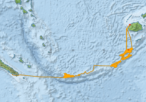
Voyage extents: 22° 36.4' S to 17° 35.9' S 166° 22.7' E to 177° 42.1' E Get voyage track shapefile Get CSV
Marlin Metadata:-
Participants - on ship:-
| Name | Role | Organisation |
|---|---|---|
| David Hutchinson | Geochemist | University of Tasmania - Hobart |
| Gisela Cobenas | PhD student | University of Tasmania - Hobart |
| Julie Hunt | Geochemist | University of Tasmania - Hobart |
| Leonid Danyushevsky | Chief Investigator | University of Tasmania - Hobart |
| Lindsay MacDonald | MNF Electronics Support | CSIRO Oceans & Atmosphere - Hobart |
| Lisa Woodward | MNF Voyage Manager | CSIRO Oceans & Atmosphere - Hobart |
| Pamela Brodie | MNF Computing Support | CSIRO Oceans & Atmosphere - Hobart |
| Patrick Quilty | Palaeontologist | University of Tasmania - Hobart |
| Pavel Plechov | Geochemist | Moscow State Univ., Russia |
| Roman Leslie | Geochemist | University of Tasmania - Hobart |
| Sandrin Feig | Geochemist | University of Tasmania - Hobart |
| Tony Veness | MNF Swath mapping support | CSIRO Oceans & Atmosphere - Hobart |
| Trevor Falloon | Watch leader/Geochemist | University of Tasmania - Hobart |
| Woitec Zukovski | Geochemist | Not recorded |
This list includes those that may have only been on part of the voyage. See voyage reports on 'Reports and Maps' tab for details.
Marine National Facility Reports - plans, summaries and data processing
-
SS2009_V03 Voyage Plan
- includes objectives, investigator details, proposed data collection, voyage track and equipment to be used.
-
SS2009_V03 Underway Data Processing Report
- details of data processing steps, calibration information, instruments used and any issues with the data.
-
SS2009_V03 Scientific Highlight
- report of the key outputs
-
SS2009_V03 Voyage Summary
- includes preliminary results, voyage narrative, types of data collected with C77/ROSCOP codes.
-

Publications, reports and datasets from this voyage.
Dataset
- Bakker, Dorothee C E; Pfeil, Benjamin; Smith, Karl; Hankin, Steven; Olsen, Are; Alin, Simone R; Cosca, Catherine E; Harasawa, Sumiko; Kozyr, Alexander; Nojiri, Yukihiro; O'Brien, Kevin M; Schuster, Ute; Telszewski, Maciej; Tilbrook, Bronte; Wada, Chisato; Akl, John; Barbero, Leticia; Bates, Nicolas R; Boutin, Jacqueline; Bozec, Yann; Cai, Wei-Jun; Castle, Robert D; Chavez, Francisco P; Chen, Lei; Chierici, Melissa; Currie, Kim I; de Baar, Hein J W; Evans, Wiley; Feely, Richard A; Fransson, Agneta; Gao, Zhongyong; Hales, Burke; Hardman-Mountford, Nicolas J; Hoppema, Mario; Huang, Wei-Jen; Hunt, Christopher W; Huss, Betty; Ichikawa, Tadafumi; Johannessen, Truls; Jones, Elizabeth M; Jones, Steve D; Jutterstrøm, Sara; Kitidis, Vassilis; Körtzinger, Arne; Landschützer, Peter; Lauvset, Siv K; Lefèvre, Nathalie; Manke, Ansley; Mathis, Jeremy T; Merlivat, Liliane; Metzl, Nicolas; Murata, Akihiko; Newberger, Timothy; Omar, Abdirahman M; Ono, Tsuneo; Park, Geun-Ha; Paterson, Kristina; Pierrot, Denis; Ríos, Aida F; Sabine, Christopher L; Saito, Shu; Salisbury, Joe; Sarma, Vedula V S S; Schlitzer, Reiner; Sieger, Rainer; Skjelvan, Ingunn; Steinhoff, Tobias; Sullivan, Kevin; Sun, Heng; Sutton, Adrienne; Suzuki, Toru; Sweeney, Colm; Takahashi, Taro; Tjiputra, Jerry; Tsurushima, Nobuo; van Heuven, Steven; Vandemark, Doug; Vlahos, Penny; Wallace, Douglas WR; Wanninkhof, Rik; Watson, Andrew J (2014): Surface Ocean CO2 Atlas (SOCAT) V2. PANGAEA, 10.1594/PANGAEA.811776
- Smith, S. R.,Lopez, N.,Bourassa, M. A. (2016) SAMOS air‐sea fluxes: 2005–2014. Geoscience Data Journal 3 pp9-19. 10.1002/gdj3.34
Journal Article
- Henschke, N,Bowden, DA,Everett, JD,Holmes, SP,Kloser, RJ,Lee, RW,Suthers, IM (2013) Salp-falls in the Tasman Sea: a major food input to deep-sea benthos. Marine Ecology Progress Series 491 pp165-175. 10.3354/meps10450
- McCarthy, A.,Falloon, T.J.,Danyushevsky, L.V.,Sauermilch, I.,Patriat, M.,Jean, M.M.,Maas, R.,Woodhead, J.D.,Yogodzinski, G.M. (2022) Implications of high-Mg# adakitic magmatism at Hunter Ridge for arc magmatism of the Fiji - Vanuatu region. Earth and Planetary Science Letters 590 pp117592-. 10.1016/j.epsl.2022.117592
- Patriat, M.,Collot, J.,Danyushevsky, L.,Fabre, M.,Meffre, S.,Falloon, T.,Rouillard, P.,Pelletier, B.,Roach, M.,Fournier, M. (2015) Propagation of back-arc extension into the arc lithosphere in the southern New Hebrides volcanic arc. Geochemistry, Geophysics, Geosystems 16 pp3142-3159. 10.1002/2015gc005717
- Patriat, Martin,Falloon, Trevor,Danyushevsky, Leonid,Collot, Julien,Jean, Marlon M.,Hoernle, Kaj,Hauff, Folkmar,Maas, Roland,Woodhead, Jon D.,Feig, Sandrin T. (2019) Subduction initiation terranes exposed at the front of a 2 Ma volcanically-active subduction zone. Earth and Planetary Science Letters 508 pp30-40. 10.1016/j.epsl.2018.12.011
Search for publications, reports and datasets from this and other voyages
Data publishing
This is a list of online datasets hosted by CSIRO. Other processed datasets hosted by collaborating organisations may be found on the 'Metadata' or "Reports, Publications and Maps' tab.
Use the Get data link on the right to extract data using the NCMI Data Trawler.
| Data Stream | Data Summary | Get data | ||||||||||||
|---|---|---|---|---|---|---|---|---|---|---|---|---|---|---|
| Multibeam echosounder |
|
Get Data from Trawler |
||||||||||||
| pCO2 |
|
External link - download datafile at IMOS |
||||||||||||
| Underway |
|
Get Data from Trawler Download NetCDF dataset ss2009_v03UWYnc.zip |
||||||||||||
| XBT Profile |
|
Get Data from Trawler Download xbt_ascii_ma_2007_2012.zip (MEDS ASCII format ) Download xbt_nc_ss2007_2012.zip (NetCDF format) |
Deployments by start time:- Click on column header to sort. Use link on 'Deployment' to see full details. Use the CSV button at the bottom to export data (tab delimited).
Search for deployments from this voyage and others
| Deployment | Operation | Station | Cast | Gear | Project | Start and end times | Start Location | End Location | Depth range | Max Depth | Description | |||
|---|---|---|---|---|---|---|---|---|---|---|---|---|---|---|
| Multibeam echosounder [details] | EM300 Multibeam Echosounder | 2009-07-03 04:00 | 2009-07-26 16:47 | -17.6029 | 177.4393 | -22.3386 | 167.0570 | 5998.7 | ||||||
| Underway System [details] | Air Temperature Sensor-HMP233,Barometer,Fluorometer WS3S-443P,Gyro-Generic SS-NF,Humidity Sensor-HMP233,IMOS Port Pyranometer-SN 35123F3,IMOS Port Radiometer-SN 35093F3,IMOS Stbd Pyranometer-SN 35122F3,IMOS Stbd Radiometer-SN 35111F3,IMOS rain gauge,IMOS rain gauge,IMOS wind monitor,IMOS wind monitor,IMOS wind monitor,IMOS wind monitor,Licor-UWQ 3708,RM Young 05106 wind monitor-75621,RM Young 05106 wind monitor-75621,RM Young 05106 wind monitor-75621,RM Young Rain Gauge,Remote Temperature (T)-SN 2621,Seapath 200,Seapath 200,Simrad EA500 Echosounder,ThermoSalinoGraph (TSG)-SS-SN 1777 | 1935 | 2009-07-03 04:01 | 2009-07-26 21:05 | -17.6020 | 177.4397 | -22.2651 | 166.4366 | ||||||
| XBT Cast [details] | Sippican Deep Blue | 2391 | 2009-07-03 21:11 | -19.9732 | 177.3096 | 1028.5 | ||||||||