Voyage details and related metadata, reports, events and data.
SS 05/2008
(alternative identifier: SS200805)
- is a Marine National Facility ![]() voyage
voyage
Period: 2008-04-05 00:00 to 2008-04-07 00:00 UTC
Duration: 2.00 days
From: Hobart To: Hobart
Region: Southern Ocean
Ship: Southern Surveyor [details]
Description: PULSE: Mooring-based measurement of Sub-Antarctic seasonal biogeochemical cycles affecting ocean uptake of carbon dioxide
Leader: Tom Trull (Antarctic CRC)
Project: Sub-Antarctic Zone (SAZ) Project (Antarctic CRC) 1997-2008 [details]
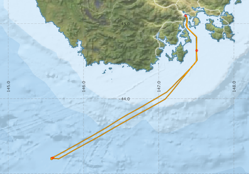
Voyage extents: 44° 48.6' S to 42° 53.7' S 145° 33.6' E to 147° 30.6' E Get voyage track shapefile Get CSV
Marlin Metadata:-
Participants - on ship:-
| Name | Role | Organisation |
|---|---|---|
| Drew Mills | Voyage Manager/ Electronics support | CSIRO Oceans & Atmosphere - Hobart |
| Joe Adelstein | Mooring recovery support | ACECRC-IMOS |
| Lindsay Pender | Mooring recovery leader, Computing support | CSIRO Oceans & Atmosphere - Hobart |
| Stephen Bray | Mooring recovery support | Antarctic Cooperative Research Centre |
| Tom Trull | Chief Scientist | UTAS-CSIRO-ACECRC |
This list includes those that may have only been on part of the voyage. See voyage reports on 'Reports and Maps' tab for details.
Marine National Facility Reports - plans, summaries and data processing
-
SS200805 Voyage Plan
- includes objectives, investigator details, proposed data collection, voyage track and equipment to be used.
-
SS200805 Voyage Summary
- includes preliminary results, voyage narrative, types of data collected with C77/ROSCOP codes.
-
SS200805 Scientific Highlight
- report of the key outputs
-

Publications, reports and datasets from this voyage.
Dataset
- Bakker, Dorothee C E; Pfeil, Benjamin; Smith, Karl; Hankin, Steven; Olsen, Are; Alin, Simone R; Cosca, Catherine E; Harasawa, Sumiko; Kozyr, Alexander; Nojiri, Yukihiro; O'Brien, Kevin M; Schuster, Ute; Telszewski, Maciej; Tilbrook, Bronte; Wada, Chisato; Akl, John; Barbero, Leticia; Bates, Nicolas R; Boutin, Jacqueline; Bozec, Yann; Cai, Wei-Jun; Castle, Robert D; Chavez, Francisco P; Chen, Lei; Chierici, Melissa; Currie, Kim I; de Baar, Hein J W; Evans, Wiley; Feely, Richard A; Fransson, Agneta; Gao, Zhongyong; Hales, Burke; Hardman-Mountford, Nicolas J; Hoppema, Mario; Huang, Wei-Jen; Hunt, Christopher W; Huss, Betty; Ichikawa, Tadafumi; Johannessen, Truls; Jones, Elizabeth M; Jones, Steve D; Jutterstrøm, Sara; Kitidis, Vassilis; Körtzinger, Arne; Landschützer, Peter; Lauvset, Siv K; Lefèvre, Nathalie; Manke, Ansley; Mathis, Jeremy T; Merlivat, Liliane; Metzl, Nicolas; Murata, Akihiko; Newberger, Timothy; Omar, Abdirahman M; Ono, Tsuneo; Park, Geun-Ha; Paterson, Kristina; Pierrot, Denis; Ríos, Aida F; Sabine, Christopher L; Saito, Shu; Salisbury, Joe; Sarma, Vedula V S S; Schlitzer, Reiner; Sieger, Rainer; Skjelvan, Ingunn; Steinhoff, Tobias; Sullivan, Kevin; Sun, Heng; Sutton, Adrienne; Suzuki, Toru; Sweeney, Colm; Takahashi, Taro; Tjiputra, Jerry; Tsurushima, Nobuo; van Heuven, Steven; Vandemark, Doug; Vlahos, Penny; Wallace, Douglas WR; Wanninkhof, Rik; Watson, Andrew J (2014): Surface Ocean CO2 Atlas (SOCAT) V2. PANGAEA, 10.1594/PANGAEA.811776
- Smith, S. R.,Lopez, N.,Bourassa, M. A. (2016) SAMOS air‐sea fluxes: 2005–2014. Geoscience Data Journal 3 pp9-19. 10.1002/gdj3.34
Journal Article
- Pratama, Gregorius A.,Virgili, Riccardo,Reimer, James D.,Fujita, Toshihiko (2024) Nesometra integra, a New Species of Feather Star (Echinodermata: Crinoidea: Comatulida: Antedonidae) from Southern Japan and Western Australia. Species Diversity 29 pp255-268. 10.12782/specdiv.29.255
Search for publications, reports and datasets from this and other voyages
Data publishing
This is a list of online datasets hosted by CSIRO. Other processed datasets hosted by collaborating organisations may be found on the 'Metadata' or "Reports, Publications and Maps' tab.
Use the Get data link on the right to extract data using the NCMI Data Trawler.
| Data Stream | Data Summary | Get data | ||||||||||||||
|---|---|---|---|---|---|---|---|---|---|---|---|---|---|---|---|---|
| ADCP Data |
|
Get Data from Trawler Download netCDF dataset ss200805.zip SS200805_UWY_ADCP_Report.pdf |
||||||||||||||
| Multibeam echosounder |
|
Get Data from Trawler |
||||||||||||||
| pCO2 |
|
External link - download datafile at IMOS |
||||||||||||||
| Underway |
|
Get Data from Trawler |
Deployments by start time:- Click on column header to sort. Use link on 'Deployment' to see full details. Use the CSV button at the bottom to export data (tab delimited).
Search for deployments from this voyage and others
| Deployment | Operation | Station | Cast | Gear | Project | Start and end times | Start Location | End Location | Depth range | Max Depth | Description | |||
|---|---|---|---|---|---|---|---|---|---|---|---|---|---|---|
| Underway System [details] | Air Temperature Sensor-HMP233,Barometer,Fluorometer WS3S-443P,Gyro-Generic SS-NF,Humidity Sensor-HMP233,Licor - CTD 21 - SN 70111,Licor-UWQ 3708,RM Young 05106 wind monitor-75621,RM Young 05106 wind monitor-75621,RM Young 05106 wind monitor-75621,RM Young Rain Gauge,Seapath 200,Seapath 200,Simrad EA500 Echosounder,ThermoSalinoGraph (TSG)-SN 2753 | 1546 | 2008-04-04 21:18 | 2008-04-06 23:23 | -42.8939 | 147.3568 | -42.8948 | 147.3526 | ||||||
| Multibeam echosounder [details] | EM300 Multibeam Echosounder | 2008-04-04 23:55 | 2008-04-05 17:39 | -43.3572 | 147.5046 | -44.7839 | 145.5949 | 4662.4 | ||||||
| ADCP Data [details] | RDI Ocean Surveyor Acoustic Doppler current profiler | 1546 | 2008-04-05 15:40 | 2008-04-06 18:05 | -44.7873 | 145.5894 | -43.6438 | 147.3828 | 814 | |||||