Voyage details and related metadata, reports, events and data.
SS 01/2007
(alternative identifier: SS200701)
- is a Marine National Facility ![]() voyage
voyage
Period: 2007-02-23 21:40 to 2007-03-16 21:30 UTC
Duration: 20.99 days
From: Port Lincoln To: Port Lincoln
Region: SA coast, Great Australian Bight
Ship: Southern Surveyor [details]
Description:
Geoscience Australia GAB Survey
Bight Basin geological sampling and seepage survey:
sampling the Cretaceous section of the Bight Basin,
and investigating potential natural hydrocarbon seeps.
The main survey objective is to address existing knowledge gaps regarding the
nature and distribution of potential source rock intervals in the Bight Basin. Our current knowledge of the source potential of the basin is based on samples from wells drilled in proximal areas of the basin and geological models of the basin fill derived from seismic interpretation. This survey aims to sample the distal facies of potential source intervals of Albian-Santonian age at locations on the seaward edges of the Ceduna and Eyre Terraces. Furthermore, this survey aims to investigate potential natural hydrocarbon seepage at sites across the Ceduna Sub-basin, which may provide evidence for the presence of active petroleum systems (taken from SS01/2007 voyage plan).
Leader: C. Mitchell (GA)
Project: National Facility External Users: C. Mitchell (Geoscience Australia) [details]
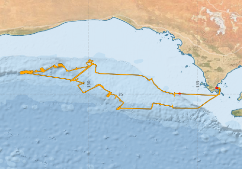
Voyage extents: 35° 43.3' S to 33° 25.0' S 126° 50.8' E to 136° 01.8' E Get voyage track shapefile Get CSV
Marlin Metadata:-
Participants - on ship:-
| Name | Role | Organisation |
|---|---|---|
| Andrew Hislop | Mechanical technician | Geoscience Australia |
| Andrew Krassay | Geologist | Geoscience Australia |
| Bob Beattie | MNF Computing, *SST | CSIRO Oceans & Atmosphere - Hobart |
| Cameron Mitchell | Chief Investigator | Geoscience Australia |
| Chris Nicholson | Geologist | Geoscience Australia |
| Craig Wintle | Mechanical technician, *SST | Geoscience Australia |
| Damien Ryan | Geologist | Geoscience Australia |
| Franz Villagran | Electrical technician | Geoscience Australia |
| George Bernardel | Shift Leader, Geologist | Geoscience Australia |
| Ian Atkinson | Systems technician | Geoscience Australia |
| Karen Earl | Geologist | Geoscience Australia |
| Matthew Carey | Geochemist | Geoscience Australia |
| Michele Spinoccia | Swath geophysicist | Geoscience Australia |
| Peter Haines | Geologist | DOIR (WA) |
| Stephen Thomas | MNF Voyage Manager, electronics, *SST | CSIRO Oceans & Atmosphere - Hobart |
This list includes those that may have only been on part of the voyage. See voyage reports on 'Reports and Maps' tab for details.
Marine National Facility Reports - plans, summaries and data processing
-
SS200701 Voyage Plan
- includes objectives, investigator details, proposed data collection, voyage track and equipment to be used.
-
SS200701 Underway Data Processing Report
- details of data processing steps, calibration information, instruments used and any issues with the data.
-
SS200701 Scientific Highlight
- report of the key outputs
-
SS200701 Voyage Summary
- includes preliminary results, voyage narrative, types of data collected with C77/ROSCOP codes.
-

Publications, reports and datasets from this voyage.
Journal Article
- Power, H. E.,Clarke, S. L. (2019) 3D seismic-derived bathymetry: a quantitative comparison with multibeam data. Geo-Marine Letters 39 pp447-467. 10.1007/s00367-019-00596-w
Report
- Totterdell, J.M. (2009). Bight Basin Geological Sampling and Seepage Survey: R/V Southern Surveyor Survey SS01/2007. Record 2009/024. Geoscience Australia, Canberra. External link to reference
Search for publications, reports and datasets from this and other voyages
Data publishing
This is a list of online datasets hosted by CSIRO. Other processed datasets hosted by collaborating organisations may be found on the 'Metadata' or "Reports, Publications and Maps' tab.
Use the Get data link on the right to extract data using the NCMI Data Trawler.
| Data Stream | Data Summary | Get data | ||||||||||||||
|---|---|---|---|---|---|---|---|---|---|---|---|---|---|---|---|---|
| ADCP Data |
|
Get Data from Trawler Download ASCII dataset ss200701ADCPasc.zip Download netCDF dataset ss200701ADPnc.zip |
||||||||||||||
| Multibeam echosounder |
|
Get Data from Trawler |
||||||||||||||
| Underway |
|
Get Data from Trawler |
Deployments by start time:- Click on column header to sort. Use link on 'Deployment' to see full details. Use the CSV button at the bottom to export data (tab delimited).
Search for deployments from this voyage and others
| Deployment | Operation | Station | Cast | Gear | Project | Start and end times | Start Location | End Location | Depth range | Max Depth | Description | |||
|---|---|---|---|---|---|---|---|---|---|---|---|---|---|---|
| Underway System [details] | Air Temperature Sensor-HMP233,Barometer,Fluorometer WS3S-443P,Gyro-Generic SS-NF,Humidity Sensor-HMP233,Licor-UWQ 3708,RM Young 05106 wind monitor-75621,RM Young 05106 wind monitor-75621,RM Young 05106 wind monitor-75621,RM Young Rain Gauge,Seapath 200,Seapath 200,Simrad EA500 Echosounder,ThermoSalinoGraph (TSG)-SS-SN 1777,ThermoSalinoGraph (TSG)-SS-SN 1777 | 2241 | 2007-02-23 21:06 | 2007-03-16 22:28 | -34.7169 | 135.8700 | -34.7167 | 135.8701 | ||||||
| Multibeam echosounder [details] | EM300 Multibeam Echosounder | 2007-02-23 21:49 | 2007-03-16 21:15 | -34.7161 | 135.8785 | -34.7167 | 135.8700 | 5218.2 | ||||||
| ADCP Data [details] | RDI Ocean Surveyor Acoustic Doppler current profiler | 2241 | 2007-02-24 07:21 | 2007-03-16 18:12 | -34.9804 | 134.1762 | -35.0321 | 135.9360 | 814 | |||||