Voyage details and related metadata, reports, events and data.
SS 10/2006
(alternative identifier: SS200610)
- is a Marine National Facility ![]() voyage
voyage
Period: 2006-10-12 21:30 to 2006-10-25 21:00 UTC
Duration: 12.98 days
From: Sydney To: Sydney
Region: Tasman Sea - NSW Coast
Ship: Southern Surveyor [details]
Description:
Southern Surveyor scientific research voyage SS 10/2006 was conducted in the
Tasman Sea off New South Wales during October 2006.
Scientific Objectives
- This survey is to assess the physical nature of the NSW continental slope.
- To improve the understanding surficial and sub surface structure of the slope
- To investigate the history of sediment movement along and down the continental slope.
Voyage Objectives
To ascertain the rate and nature of sediment movement across and along the NSW
continental slope. This will be achieved by first imaging the area utilising
the Swath, and sub bottom profiles. After this data has been acquired a range
of potential sampling sites will be selected for side scan, seismic acquisition
followed by the physical sampling effort including gravity cores, box cores
and piston cores. These sites are anticipated to reveal the timing and extent
of sediment movement.
Taken from unpublished voyage plan SS10-2006
Leader: Dr Kriton C Glenn (Geoscience Australia)
Project: National Facility External Users: K. Glenn (Geoscience Australia) [details]
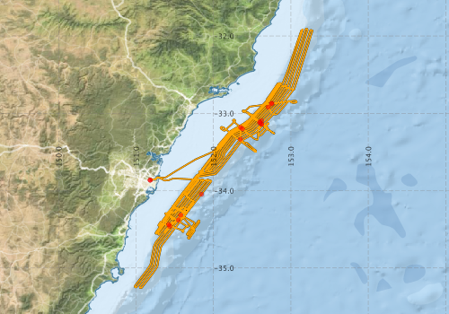
Voyage extents: 35° 15.6' S to 31° 54.2' S 150° 58.9' E to 153° 16.8' E Get voyage track shapefile Get CSV
Marlin Metadata:-
Participants - on ship:-
| Name | Role | Organisation |
|---|---|---|
| Alix Post | CSS (Continental Slope Survey) | Geoscience Australia |
| Andrew Hislop | FES (Mechanical technician) | Geoscience Australia |
| Anna Potter | CSS (Continental Slope Survey) | Geoscience Australia |
| Bob Beattie | MNF Computing & Voyage Manager | CSIRO Oceans & Atmosphere - Hobart |
| Cameron Buchanan | Swath Processing and Data Acquisition | Geoscience Australia |
| Craig Wintle | FES (Mechanical technician) | Geoscience Australia |
| Franz Villagran | FES ( Electronics technician) | Geoscience Australia |
| Ian Atkinson | FES (System technician) | Geoscience Australia |
| Jock Keene | University of Sydney | |
| Karl Forcey | MNF Electronics | CSIRO Oceans & Atmosphere - Hobart |
| Kriton Glenn | Chief Scientist CCS | Geoscience Australia |
| Leharne Fountain | CSS (Continental Slope Survey) | Geoscience Australia |
| Michele Spinoccia | Swath Processing and Data Acquisition | Geoscience Australia |
| Monica Osuchowski | CSS (Continental Slope Survey) | Geoscience Australia |
| Ron Boyd | University of Newcastle - Depart. of Geology |
This list includes those that may have only been on part of the voyage. See voyage reports on 'Reports and Maps' tab for details.
Marine National Facility Reports - plans, summaries and data processing
-
SS200610 Scientific Highlight
- report of the key outputs
-
SS200610 Underway Data Processing Report
- details of data processing steps, calibration information, instruments used and any issues with the data.
-
SS200610 Voyage Summary
- includes preliminary results, voyage narrative, types of data collected with C77/ROSCOP codes.
-
SS200610 Voyage Plan
- includes objectives, investigator details, proposed data collection, voyage track and equipment to be used.
-

Publications, reports and datasets from this voyage.
Conference Poster
- Clarke, S., Hubble, T., Airey, D. & Ward, S. (2015), Eastern Australia's submarine landslides: implications for tsunami hazard between Jervis Bay and Fraser Island, Landslides.
External link to reference
Journal Article
- Clarke, Samantha L.,Hubble, Thomas C. T.,Miao, G.,Airey, D. W.,Ward, S. N. (2019) Eastern Australia’s submarine landslides: implications for tsunami hazard between Jervis Bay and Fraser Island. Landslides 16 pp2059-2085. 10.1007/s10346-019-01223-6
- Lucieer, Vanessa,Flukes, Emma,Monk, Jacquomo,Walsh, Peter (2024) Geomorphometric maps of Australia’s Marine Park estate and their role in improving the integrated monitoring and management of marine ecosystems. Frontiers in Marine Science 10 pp-. 10.3389/fmars.2023.1302108
Search for publications, reports and datasets from this and other voyages
Data publishing
This is a list of online datasets hosted by CSIRO. Other processed datasets hosted by collaborating organisations may be found on the 'Metadata' or "Reports, Publications and Maps' tab.
Use the Get data link on the right to extract data using the NCMI Data Trawler.
| Data Stream | Data Summary | Get data | ||||||||||||||
|---|---|---|---|---|---|---|---|---|---|---|---|---|---|---|---|---|
| ADCP Data |
|
Get Data from Trawler Download netCDF dataset ss200610ADCPnc.zip Data processing report |
||||||||||||||
| Multibeam echosounder |
|
Get Data from Trawler |
||||||||||||||
| Underway |
|
Get Data from Trawler |
||||||||||||||
| XBT Profile | No data |
Deployments by start time:- Click on column header to sort. Use link on 'Deployment' to see full details. Use the CSV button at the bottom to export data (tab delimited).
Search for deployments from this voyage and others
| Deployment | Operation | Station | Cast | Gear | Project | Start and end times | Start Location | End Location | Depth range | Max Depth | Description | |||
|---|---|---|---|---|---|---|---|---|---|---|---|---|---|---|
| Underway System [details] | Air Temperature Sensor-HMP233,Barometer,Fluorometer WS3S-443P,Gyro-Generic SS-NF,Humidity Sensor-HMP233,Licor-UWQ 3708,RM Young 05103 wind monitor,RM Young 05103 wind monitor,RM Young 05103 wind monitor,RM Young Rain Gauge,Seapath 200,Seapath 200,Simrad EA500 Echosounder,ThermoSalinoGraph (TSG)-SS-SN 1777,ThermoSalinoGraph (TSG)-SS-SN 1777 | 2239 | 2006-10-12 22:07 | 2006-10-26 00:59 | -33.8633 | 151.1828 | -33.8621 | 151.1855 | ||||||
| Multibeam echosounder [details] | EM300 Multibeam Echosounder | 2006-10-12 22:28 | 2006-10-25 21:26 | -33.8635 | 151.1830 | -33.8621 | 151.1855 | 4294.8 | ||||||
| ADCP Data [details] | RDI Ocean Surveyor Acoustic Doppler current profiler | 2239 | 2006-10-13 03:43 | 2006-10-25 17:28 | -34.0469 | 151.8455 | -33.5849 | 151.7910 | 654 | |||||
| Sediment Sampling [details] | SS102006/04GC03 | 2239 | -34.4381 | 151.4222 | ||||||||||
| Sediment Sampling [details] | SS102006/12GC11 | 2239 | -33.1095 | 152.5986 | ||||||||||
| Sediment Sampling [details] | SS102006/14GC13 | 2239 | -33.3353 | 152.3491 | ||||||||||
| Sediment Sampling [details] | SS102006/13GC12 | 2239 | -33.1402 | 152.6220 | ||||||||||
| Sediment Sampling [details] | SS102006/07GC06 | 2239 | -32.8761 | 152.7505 | ||||||||||
| Sediment Sampling [details] | SS102006/06GC05 | 2239 | -32.8711 | 152.7529 | ||||||||||
| Sediment Sampling [details] | SS102006/09GC08 | 2239 | -33.1401 | 152.6218 | ||||||||||
| Sediment Sampling [details] | SS102006/15GC14 | 2239 | -33.1817 | 152.3508 | ||||||||||
| Sediment Sampling [details] | SS102006/05GC04 | 2239 | -34.3782 | 151.5460 | ||||||||||
| Sediment Sampling [details] | SS102006/08GC07 | 2239 | -32.9202 | 152.7070 | ||||||||||
| Sediment Sampling [details] | SS102006/11GC10 | 2239 | -33.0947 | 152.6213 | ||||||||||
| Sediment Sampling [details] | SS102006/10GC09 | 2239 | -33.1224 | 152.5993 | ||||||||||
| Sediment Sampling [details] | SS102006/03GC02 | 2239 | -34.4614 | 151.4348 | ||||||||||
| Sediment Sampling [details] | SS102006/16GC15 | 2239 | -33.2013 | 152.3749 | ||||||||||
| Sediment Sampling [details] | SS102006/01GC01 | 2239 | -34.3167 | 151.5775 | ||||||||||