Voyage details and related metadata, reports, events and data.
SS 08/2006
(alternative identifier: SS200608)
- is a Marine National Facility ![]() voyage
voyage
Period: 2006-08-19 01:00 to 2006-09-10 21:00 UTC
Duration: 22.83 days
From: Suva To: Noumea
Region: SW Pacific Fiji - Vanuatu
Ship: Southern Surveyor [details]
Description:
Southern Surveyor voyage SS08/2006.
Voyage Objectives:
We intend to conduct a multibeam survey, a magnetics survey and rock sampling in three areas along the Hunter Ridge. The questions which we are seeking to answer are as follows:
Kadavu and northern Hunter Ridge (area 1)
Questions:
1) What is the lateral extent of adakites on the seafloor around Kadavu Is?
2) What is the structural relationships between the northern Hunter Ridge and Kadavu Island?
To answer these questions we plan to do detailed swath mapping, sound-bottom profiling and dredge sampling in area 1. The use of the soundbottom profiler will be vital in determining whether the seafloor has a volcanic, sediment-poor, basement or alternatively the seafloor is formed by sediments. This information will significantly help the interpretation of the swath mapping.
Rift Zone at the southern end of the Hunter Ridge (area 2)
Question:
1) What is the distribution of different magma types withinthe rift?
To answer this question we wish to perform 10-15 dredges within the main rift zone between 1500-2500m water depth.
North Fiji Basin propagating spreading centre (area 3)
Question:
1) What is the age and rate of southward propagation of the spreading centre?
We plan to conduct a magnetic survey along 3 lines across the spreading ridge to obtain magnetic profiles. Due to the limited time during voyage SS10/2004 to conduct a detailed sampling of the spreading centre, we plan to do further sampling using a specially modified piston corer, designed for sampling glassy pillow rinds of young lavas.
Taken from unpublished voyage plan (CSIRO 2006).
Leader: Assoc. Prof. L. Danyushevsky (Tas Uni)
Project: National Facility External Users: L. Danyushevsky (University of Tasmania) [details]
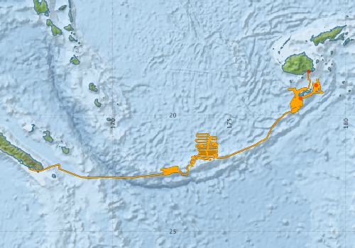
Voyage extents: 22° 41.3' S to 18° 07.7' S 166° 25.3' E to 179° 00.8' E Get voyage track shapefile Get CSV
Marlin Metadata:-
Participants - on ship:-
| Name | Role | Organisation |
|---|---|---|
| Andrew Stacey | Geophysicist; PhD student | University of Tasmania - Hobart |
| Bob Beattie | Computing Support/ SST | CSIRO Oceans & Atmosphere - Hobart |
| Fijian rep. TBC | Geologist | MRD, Fiji |
| Leonid Danyushevsky | Chief Investigator | University of Tasmania - Hobart |
| Michael Roach | Geophysicist | University of Tasmania - Hobart |
| Michele Spinoccia | Swath data processing | Geoscience Australia |
| Michelle Farran | Geologist; PhD student | University of Tasmania - Hobart |
| Patrick Quilty | Palaeontologist | University of Tasmania - Hobart |
| Pavel Plechov | Geochemist | Moscow State Univ., Russia |
| Roman Leslie | Geochemist | University of Tasmania - Hobart |
| Stephen Thomas | Electronics Support/Voyage Manager | CSIRO Oceans & Atmosphere - Hobart |
| Trevor Falloon | Geochemist | University of Tasmania - Hobart |
| Vanuatu rep. TBC | Geologist | Vanuatu geological survey |
This list includes those that may have only been on part of the voyage. See voyage reports on 'Reports and Maps' tab for details.
Marine National Facility Reports - plans, summaries and data processing
-
SS200608 Voyage Plan
- includes objectives, investigator details, proposed data collection, voyage track and equipment to be used.
-
SS200608 Underway Data Processing Report
- details of data processing steps, calibration information, instruments used and any issues with the data.
-
SS200608 Scientific Highlight
- report of the key outputs
-
SS200608 Voyage Summary
- includes preliminary results, voyage narrative, types of data collected with C77/ROSCOP codes.
-

Publications, reports and datasets from this voyage.
Dataset
- Geoscience Australia (2008) Videos from SS0608 (Lord Howe Rise). Geoscience Australia, Canberra. 10.4225/25/55010DC8EE8D5
Journal Article
- Kendrick, Mark A.,Arculus, Richard J.,Danyushevsky, Leonid V.,Kamenetsky, Vadim S.,Woodhead, Jon D.,Honda, Masahiko (2014) Subduction-related halogens (Cl, Br and I) and H2O in magmatic glasses from Southwest Pacific Backarc Basins. Earth and Planetary Science Letters 400 pp165-176. 10.1016/j.epsl.2014.05.021
- Kendrick, Mark A.,Danyushevsky, Leonid V.,Falloon, Trevor J.,Woodhead, Jon D.,Arculus, Richard J.,Ireland, Trevor (2020) SW Pacific arc and backarc lavas and the role of slab-bend serpentinites in the global halogen cycle. Earth and Planetary Science Letters 530 pp115921-. 10.1016/j.epsl.2019.115921
- O'Neill, Hugh St.C.,Berry, Andrew J.,Danyushevsky, Leonid V.,Falloon, Trevor J.,Maas, Roland,Feig, Sandrin T. (2024) The relationship between iron redox states and H2O contents in back-arc basin basaltic glasses from the North Fiji Basin. Chemical Geology 655 pp122062-. 10.1016/j.chemgeo.2024.122062
- Patriat, M.,Collot, J.,Danyushevsky, L.,Fabre, M.,Meffre, S.,Falloon, T.,Rouillard, P.,Pelletier, B.,Roach, M.,Fournier, M. (2015) Propagation of back-arc extension into the arc lithosphere in the southern New Hebrides volcanic arc. Geochemistry, Geophysics, Geosystems 16 pp3142-3159. 10.1002/2015gc005717
- Patriat, Martin,Falloon, Trevor,Danyushevsky, Leonid,Collot, Julien,Jean, Marlon M.,Hoernle, Kaj,Hauff, Folkmar,Maas, Roland,Woodhead, Jon D.,Feig, Sandrin T. (2019) Subduction initiation terranes exposed at the front of a 2 Ma volcanically-active subduction zone. Earth and Planetary Science Letters 508 pp30-40. 10.1016/j.epsl.2018.12.011
Search for publications, reports and datasets from this and other voyages
Data publishing
This is a list of online datasets hosted by CSIRO. Other processed datasets hosted by collaborating organisations may be found on the 'Metadata' or "Reports, Publications and Maps' tab.
Use the Get data link on the right to extract data using the NCMI Data Trawler.
| Data Stream | Data Summary | Get data | ||||||||||||||
|---|---|---|---|---|---|---|---|---|---|---|---|---|---|---|---|---|
| ADCP Data |
|
Get Data from Trawler Download netCDF dataset ss200608ADPnc.zip Data processing report |
||||||||||||||
| Multibeam echosounder |
|
Get Data from Trawler |
||||||||||||||
| Underway |
|
Get Data from Trawler |
Deployments by start time:- Click on column header to sort. Use link on 'Deployment' to see full details. Use the CSV button at the bottom to export data (tab delimited).
Search for deployments from this voyage and others
| Deployment | Operation | Station | Cast | Gear | Project | Start and end times | Start Location | End Location | Depth range | Max Depth | Description | |||
|---|---|---|---|---|---|---|---|---|---|---|---|---|---|---|
| Underway System [details] | Air Temperature Sensor-HMP233,Barometer,Fluorometer WS3S-443P,Gyro-Generic SS-NF,Humidity Sensor-HMP233,Licor-UWQ 3708,RM Young 05103 wind monitor,RM Young 05103 wind monitor,RM Young 05103 wind monitor,RM Young Rain Gauge,Seapath 200,Seapath 200,Simrad EA500 Echosounder,ThermoSalinoGraph (TSG)-SS-SN 1777,ThermoSalinoGraph (TSG)-SS-SN 1777 | 1935 | 2006-08-19 00:43 | 2006-09-10 20:47 | -18.1321 | 178.4244 | -22.2686 | 166.4338 | ||||||
| Multibeam echosounder [details] | EM300 Multibeam Echosounder | 2006-08-24 00:00 | 2006-09-10 19:58 | -18.7239 | 178.7297 | -22.2709 | 166.4346 | 5530 | ||||||
| ADCP Data [details] | RDI Ocean Surveyor Acoustic Doppler current profiler | 1935 | 2006-08-26 01:46 | 2006-09-10 01:26 | -19.2783 | 178.0570 | -22.6842 | 169.2487 | 814 | |||||