Voyage details and related metadata, reports, events and data.
SS 09/2005
(alternative identifier: SS200509)
- is a Marine National Facility ![]() voyage
voyage
Period: 2005-10-21 08:00 to 2005-11-12 01:00 UTC
Duration: 21.71 days
From: Fremantle To: Fremantle
Region: Indian Ocean off Western Australia
Ship: Southern Surveyor [details]
Description:
Southern Surveyor research voyage SS200509.
Principal Investigator: Prof Anthony J Crawford (UTAS)
The key target of this research voyage is to multibeam swath-map and sample by
dredging the basement rocks of the Naturaliste Plateau and the Diamantina Zone
immediately further south.
21 October - 10 NOvember 2005.
Leader: Prof Anthony J Crawford (Tas Uni)
Project: National Facility External Users: T. Crawford (University of Tasmania) [details]
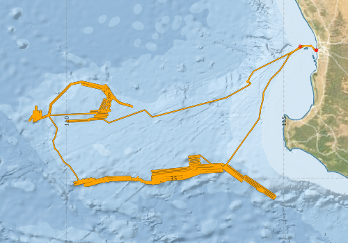
Voyage extents: 35° 28.8' S to 31° 56.2' S 109° 07.8' E to 115° 44.7' E Get voyage track shapefile Get CSV
Marlin Metadata:-
Participants - on ship:-
| Name | Role | Organisation |
|---|---|---|
| Bence Paul | PhD student | University of Melbourne |
| Benjamin Cohen | PhD student | University of Queensland |
| Bob Beattie | Voyage Manager/Computing Support | CSIRO Oceans & Atmosphere - Hobart |
| Cameron Buchanan | Swath mapping | Geoscience Australia |
| Cameron Hamilton | Student | University of Tasmania - Hobart |
| Caroline Forbes | Geological Survey of WA | |
| Galen Pettigrew | Student | University of Tasmania - Hobart |
| Lesja Mitrovic | PhD student | University of Adelaide |
| Mike Coffin | University of Tokyo | |
| Nick Direen | University of Adelaide | |
| Stephen Thomas | Electronics Support | CSIRO Oceans & Atmosphere - Hobart |
| Tony Crawford | Chief Investigator | University of Tasmania - Hobart |
This list includes those that may have only been on part of the voyage. See voyage reports on 'Reports and Maps' tab for details.
Marine National Facility Reports - plans, summaries and data processing
-
SS200509 Scientific Highlight
- report of the key outputs
-
SS200509 Underway Data Processing Report
- details of data processing steps, calibration information, instruments used and any issues with the data.
-
SS200509 Voyage Summary
- includes preliminary results, voyage narrative, types of data collected with C77/ROSCOP codes.
-
SS200509 Voyage Plan
- includes objectives, investigator details, proposed data collection, voyage track and equipment to be used.
-

Publications, reports and datasets from this voyage.
Dataset
- Asimus, J., & Halpin, J. (2025). Data appendices for: Kerguelen Plateau: Interplay between a mantle plume, microcontinents and ocean spreading ridges [Data set]. Institute for Marine and Antarctic Studies. 10.25959/Q88B-4S29
Journal Article
- Direen, N. G.,Cohen, B. E.,Maas, R.,Frey, F. A.,Whittaker, J. M.,Coffin, M. F.,Meffre, S.,Halpin, J. A.,Crawford, A. J. (2017) Naturaliste Plateau: constraints on the timing and evolution of the Kerguelen Large Igneous Province and its role in Gondwana breakup. Australian Journal of Earth Sciences 64 pp851-869. 10.1080/08120099.2017.1367326
- Halpin, Jacqueline A.,Crawford, Anthony J.,Direen, Nicholas G.,Coffin, Millard F.,Forbes, Caroline J. (2008) Naturaliste Plateau, offshore Western Australia: A submarine window into Gondwana assembly and breakup. Geology 36 pp807-. 10.1130/G25059A.1
Search for publications, reports and datasets from this and other voyages
Data publishing
This is a list of online datasets hosted by CSIRO. Other processed datasets hosted by collaborating organisations may be found on the 'Metadata' or "Reports, Publications and Maps' tab.
Use the Get data link on the right to extract data using the NCMI Data Trawler.
| Data Stream | Data Summary | Get data | ||||||||||||||
|---|---|---|---|---|---|---|---|---|---|---|---|---|---|---|---|---|
| ADCP Data |
|
Get Data from Trawler Download NetCDF dataset ss200509ADPnc.zip Data processing report |
||||||||||||||
| Multibeam echosounder |
|
Get Data from Trawler |
||||||||||||||
| Underway |
|
Get Data from Trawler |
Deployments by start time:- Click on column header to sort. Use link on 'Deployment' to see full details. Use the CSV button at the bottom to export data (tab delimited).
Search for deployments from this voyage and others
| Deployment | Operation | Station | Cast | Gear | Project | Start and end times | Start Location | End Location | Depth range | Max Depth | Description | |||
|---|---|---|---|---|---|---|---|---|---|---|---|---|---|---|
| Underway System [details] | Air Temperature Sensor-HMP233,Barometer,Fluorometer WS3S-443P,Gyro-Generic SS-NF,Humidity Sensor-HMP233,Licor-UWQ 3708,RM Young 05103 wind monitor,RM Young 05103 wind monitor,Seapath 200,Seapath 200,Simrad EA500 Echosounder,ThermoSalinoGraph (TSG)-SS-SN 1777,ThermoSalinoGraph (TSG)-SS-SN 1777 | 1706 | 2005-10-21 08:05 | 2005-11-12 01:59 | -32.0492 | 115.7456 | -32.0491 | 115.7457 | ||||||
| Multibeam echosounder [details] | EM300 Multibeam Echosounder | 2005-10-21 08:17 | 2005-11-12 01:39 | -32.0490 | 115.7454 | -32.0491 | 115.7457 | 6366.4 | ||||||
| ADCP Data [details] | RDI Ocean Surveyor Acoustic Doppler current profiler | 1706 | 2005-10-21 10:51 | 2005-11-11 20:05 | -31.9619 | 115.3756 | -32.1881 | 114.9952 | 814 | |||||