Voyage details and related metadata, reports, events and data.
SS 72/2004
(alternative identifier: SS200472)
- is a Marine National Facility ![]() voyage
voyage
Period: 2004-08-13 00:00 to 2004-08-16 00:00 UTC
Duration: 3.00 days
From: Hobart To: Sydney
Region: NSW Coast, Bass Strait, Tasmania East Coast
Ship: Southern Surveyor [details]
Description: Southern Surveyor Transit from Hobart to Sydney. Bernadette Heaney and Steve Thomas worked on this voyage to test equipment and acquire data. Underway and Swath Map data were acquired.
Project: Southern Surveyor - general vessel operations, gear trials, etc. [details]
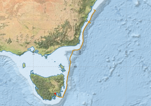
Voyage extents: 43° 17.0' S to 33° 52.6' S 147° 20.3' E to 151° 41.3' E Get voyage track shapefile Get CSV
Marlin Metadata:-
Participants - on ship:-
| Name | Role | Organisation |
|---|---|---|
| no docs found | CSIRO Oceans & Atmosphere - Hobart |
This list includes those that may have only been on part of the voyage. See voyage reports on 'Reports and Maps' tab for details.
Marine National Facility Reports - plans, summaries and data processing
-
SS200472 Underway Data Processing Report
- details of data processing steps, calibration information, instruments used and any issues with the data.
-

Search for publications, reports and datasets from this and other voyages
Data publishing
This is a list of online datasets hosted by CSIRO. Other processed datasets hosted by collaborating organisations may be found on the 'Metadata' or "Reports, Publications and Maps' tab.
Use the Get data link on the right to extract data using the NCMI Data Trawler.
| Data Stream | Data Summary | Get data | ||||||||||||
|---|---|---|---|---|---|---|---|---|---|---|---|---|---|---|
| Multibeam echosounder |
|
Get Data from Trawler |
||||||||||||
| Underway |
|
Get Data from Trawler |
Deployments by start time:- Click on column header to sort. Use link on 'Deployment' to see full details. Use the CSV button at the bottom to export data (tab delimited).
Search for deployments from this voyage and others
| Deployment | Operation | Station | Cast | Gear | Project | Start and end times | Start Location | End Location | Depth range | Max Depth | Description | |||
|---|---|---|---|---|---|---|---|---|---|---|---|---|---|---|
| Underway System [details] | Air Temperature Sensor-HMP233,Barometer,Fluorometer WS3S-026,Gyro-Generic SS-NF,Humidity Sensor-HMP233,Licor-UWQ 3708,RM Young 05103 wind monitor,RM Young 05103 wind monitor,Seapath 200,Seapath 200,Simrad EA500 Echosounder,ThermoSalinoGraph (TSG)-SS-SN 1777,ThermoSalinoGraph (TSG)-SS-SN 1777 | 1545 | 2004-08-13 05:48 | 2004-08-16 01:08 | -42.8864 | 147.3387 | -33.8772 | 151.4809 | ||||||
| Multibeam echosounder [details] | EM300 Multibeam Echosounder | 2004-08-13 07:10 | 2004-08-16 01:07 | -42.9032 | 147.3660 | -33.8781 | 151.4829 | 3431.5 | ||||||