Voyage details and related metadata, reports, events and data.
SS 10/2004
(alternative identifier: SS200410)
- is a Marine National Facility ![]() voyage
voyage
Period: 2004-10-02 00:00 to 2004-10-25 21:00 UTC
Duration: 23.88 days
From: Brisbane To: Nuku'alofa
Region: West Pacific; Fiji - Vanuatu
Ship: Southern Surveyor [details]
Description: Southern Surveyor voyage SS 10/2004 conducted research into Hot subduction recycling of oceanic crust in a dynamic W Pacific setting the ship spent 8.5 days in transit from Brisbane to the study area and from the study area to Tonga. Ths ship spent 16.5 days dredging and swath mapping in the study area 172.7-174.4oE and 21-22.5oS in the Western Pacific ocean between Fiji and Vanuatu during October 2004.
Leader: L. Danyushevsky (Tas Uni)
Project: National Facility External Users: L. Danyushevsky (University of Tasmania) [details]
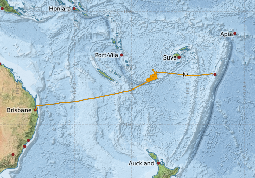
Voyage extents: 27° 26.9' S to 20° 17.1' S 153° 05.1' E to 175° 39.8' W Get voyage track shapefile Get CSV
Marlin Metadata:-
Participants - on ship:-
| Name | Role | Organisation |
|---|---|---|
| Andrea Cortese | Swath Mapping | Geoscience Australia |
| Andrew Stacey | Geochemist | University of Tasmania - Hobart |
| Chris Small | Geophysicist | Columbia University |
| Drew Mills | Electronics Support | CSIRO Oceans & Atmosphere - Hobart |
| Hiski Kippo | Computing Support (Trainee) | CSIRO Oceans & Atmosphere - Hobart |
| Ilai Waga | Geologist | MRD, Fiji |
| Leonid Danyushevsky | Chief Investigator | University of Tasmania - Hobart |
| Michele Spinoccia | Swath Mapping | Geoscience Australia |
| Pamela Brodie | Computing/Voyage Manager | CSIRO Oceans & Atmosphere - Hobart |
| Patricia Sie | Geochemist | Monash University |
| Sofia Tetroeva | Geochemist | University of Tasmania - Hobart |
| Trevor Falloon | Geochemist | consultant |
This list includes those that may have only been on part of the voyage. See voyage reports on 'Reports and Maps' tab for details.
Marine National Facility Reports - plans, summaries and data processing
-
SS200410 Scientific Highlight
- report of the key outputs
-
SS200410 Underway Data Processing Report
- details of data processing steps, calibration information, instruments used and any issues with the data.
-
SS200410 Voyage Summary
- includes preliminary results, voyage narrative, types of data collected with C77/ROSCOP codes.
-
SS200410 Voyage Plan
- includes objectives, investigator details, proposed data collection, voyage track and equipment to be used.
-

Publications, reports and datasets from this voyage.
Conference Proceedings
- Danyushevsky, Leonid,Falloon, Trevor,Crawford, Anthony (2019) Subduction-related magmatism at the southern tip of the North Fiji backarc basin. ASEG Extended Abstracts 2006 pp1-8. 10.1071/aseg2006ab032
Journal Article
- Kendrick, Mark A.,Danyushevsky, Leonid V.,Falloon, Trevor J.,Woodhead, Jon D.,Arculus, Richard J.,Ireland, Trevor (2020) SW Pacific arc and backarc lavas and the role of slab-bend serpentinites in the global halogen cycle. Earth and Planetary Science Letters 530 pp115921-. 10.1016/j.epsl.2019.115921
- McCarthy, A.,Falloon, T.J.,Danyushevsky, L.V.,Sauermilch, I.,Patriat, M.,Jean, M.M.,Maas, R.,Woodhead, J.D.,Yogodzinski, G.M. (2022) Implications of high-Mg# adakitic magmatism at Hunter Ridge for arc magmatism of the Fiji - Vanuatu region. Earth and Planetary Science Letters 590 pp117592-. 10.1016/j.epsl.2022.117592
- O'Neill, Hugh St.C.,Berry, Andrew J.,Danyushevsky, Leonid V.,Falloon, Trevor J.,Maas, Roland,Feig, Sandrin T. (2024) The relationship between iron redox states and H2O contents in back-arc basin basaltic glasses from the North Fiji Basin. Chemical Geology 655 pp122062-. 10.1016/j.chemgeo.2024.122062
- Patriat, M.,Collot, J.,Danyushevsky, L.,Fabre, M.,Meffre, S.,Falloon, T.,Rouillard, P.,Pelletier, B.,Roach, M.,Fournier, M. (2015) Propagation of back-arc extension into the arc lithosphere in the southern New Hebrides volcanic arc. Geochemistry, Geophysics, Geosystems 16 pp3142-3159. 10.1002/2015gc005717
- Patriat, Martin,Falloon, Trevor,Danyushevsky, Leonid,Collot, Julien,Jean, Marlon M.,Hoernle, Kaj,Hauff, Folkmar,Maas, Roland,Woodhead, Jon D.,Feig, Sandrin T. (2019) Subduction initiation terranes exposed at the front of a 2 Ma volcanically-active subduction zone. Earth and Planetary Science Letters 508 pp30-40. 10.1016/j.epsl.2018.12.011
Search for publications, reports and datasets from this and other voyages
Data publishing
This is a list of online datasets hosted by CSIRO. Other processed datasets hosted by collaborating organisations may be found on the 'Metadata' or "Reports, Publications and Maps' tab.
Use the Get data link on the right to extract data using the NCMI Data Trawler.
| Data Stream | Data Summary | Get data | ||||||||||||||
|---|---|---|---|---|---|---|---|---|---|---|---|---|---|---|---|---|
| ADCP Data |
|
Get Data from Trawler Download dataset 10.5 / 2.3 Mb Processing report for this dataset |
||||||||||||||
| Multibeam echosounder |
|
Get Data from Trawler |
||||||||||||||
| Underway |
|
Get Data from Trawler |
Deployments by start time:- Click on column header to sort. Use link on 'Deployment' to see full details. Use the CSV button at the bottom to export data (tab delimited).
Search for deployments from this voyage and others
| Deployment | Operation | Station | Cast | Gear | Project | Start and end times | Start Location | End Location | Depth range | Max Depth | Description | |||
|---|---|---|---|---|---|---|---|---|---|---|---|---|---|---|
| Underway System [details] | Air Temperature Sensor-HMP233,Barometer,Fluorometer WS3S-026,Gyro-Generic SS-NF,Humidity Sensor-HMP233,Licor-UWQ 3708,RM Young 05103 wind monitor,RM Young 05103 wind monitor,Seapath 200,Seapath 200,Simrad EA500 Echosounder,ThermoSalinoGraph (TSG)-SS-SN 1777,ThermoSalinoGraph (TSG)-SS-SN 1777 | 1935 | 2004-10-02 00:11 | 2004-10-25 13:17 | -27.4472 | 153.0831 | -21.0064 | 184.3392 | ||||||
| Multibeam echosounder [details] | EM300 Multibeam Echosounder | 2004-10-02 00:52 | 2004-10-25 18:34 | -27.3936 | 153.1545 | -20.9686 | 184.8215 | 5336.9 | ||||||
| ADCP Data [details] | RDI VM-150 Acoustic Doppler current profiler | 1935 | 2004-10-02 05:20 | 2004-10-25 13:00 | -26.7200 | 153.2640 | -21.0090 | 184.3160 | 344.8 | |||||