Voyage details and related metadata, reports, events and data.
SS 05/2004
(alternative identifier: SS200405)
- is a Marine National Facility ![]() voyage
voyage
Period: 2004-05-03 00:00 to 2004-05-27 08:00 UTC
Duration: 24.33 days
From: Sydney To: Noumea
Region: Tasman Sea and the Kenn Plateau in the Coral Sea.
Ship: Southern Surveyor [details]
Description:
To acquire geoscience data from the Kenn Plateau to the abyssal plain.
- 200-4500 m water depth
- 20 to 27° South, 154 to 159° East.
- Highest priorities are seismic profiling (3300 km at 7.5 knots) and dredging (40 dredges, 500-4000 m water depth)
- Secondary priorities are magnetic profiling (on seismic profiles), swath mapping, echosounder profiling, seabed sampling (10 cores, 500-4000 m water depth) and 10 grabs, 200-1000 m water depth)
- Swath will be run the whole time, except on final transit to Nouméa
- Transits at 11 knots to and from work area.
Leader: Dr Neville Exon (Geoscience Australia)
Project: National Facility External Users: N. Exon (Geoscience Australia - [ AGSO pre 2001]) [details]
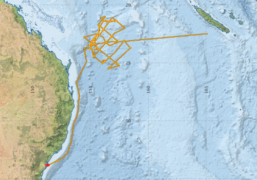
Voyage extents: 33° 49.5' S to 20° 59.3' S 151° 20.1' E to 165° 07.4' E Get voyage track shapefile Get CSV
Marlin Metadata:-
Participants - on ship:-
| Name | Role | Organisation |
|---|---|---|
| Alix Post | Geologist | Geoscience Australia |
| Bernadette Heaney | computing | CSIRO Oceans & Atmosphere - Hobart |
| Christian Heine | Geologist | University of Sydney |
| Craig Wintle | mechanical technician | Geoscience Australia |
| Franz Villagran | electronic technician | Geoscience Australia |
| Georgina Burch | Geologist | Geoscience Australia |
| Jon Stratton | science technician | Geoscience Australia |
| Lydia Taylor | geophysicist | University of Sydney |
| Neville Exon | Chief Investigator | Geoscience Australia |
| Petar Vujovic | geophysical technician | Geoscience Australia |
| Peter Hill | Senior Geophysicist | Geoscience Australia |
| Stephen Thomas | electronics & Voyage Manager | CSIRO Oceans & Atmosphere - Hobart |
| Yves Lafoy | Geologist | New Caledonian |
This list includes those that may have only been on part of the voyage. See voyage reports on 'Reports and Maps' tab for details.
Marine National Facility Reports - plans, summaries and data processing
-
SS200405 Voyage Plan
- includes objectives, investigator details, proposed data collection, voyage track and equipment to be used.
-
SS200405 Underway Data Processing Report
- details of data processing steps, calibration information, instruments used and any issues with the data.
-
SS200405 Voyage Summary
- includes preliminary results, voyage narrative, types of data collected with C77/ROSCOP codes.
-

Publications, reports and datasets from this voyage.
Journal Article
- Johnson, Alysha M.,Dickson, Mark E.,Hamylton, Sarah,Woodroffe, Colin D. (2025) The geomorphic evolution of the Tasmantid Seamount Chain. Marine Geology 486 pp107560-. 10.1016/j.margeo.2025.107560
- Mather, Ben R.,Müller, R. Dietmar,Seton, Maria,Ruttor, Saskia,Nebel, Oliver,Mortimer, Nick (2020) Intraplate volcanism triggered by bursts in slab flux. Science Advances 6 ppeabd0953-. 10.1126/sciadv.abd0953
Report
- Exon, N.F., Hill, P.J., Lafoy, Y., Burch, G.J., Post, A., Heine, C., Quilty, P.G., Howe, R., Taylor, L. (2004). The Geology of the Kenn Plateau Off Northeast Australia: Results of Southern Surveyor Cruise SS5/2004 (Geoscience Australia Cruise 270). Record 2005/004. Geoscience Australia, Canberra. External link to reference
Search for publications, reports and datasets from this and other voyages
Data publishing
This is a list of online datasets hosted by CSIRO. Other processed datasets hosted by collaborating organisations may be found on the 'Metadata' or "Reports, Publications and Maps' tab.
Use the Get data link on the right to extract data using the NCMI Data Trawler.
| Data Stream | Data Summary | Get data | ||||||||||||||
|---|---|---|---|---|---|---|---|---|---|---|---|---|---|---|---|---|
| ADCP Data |
|
Get Data from Trawler Download dataset 12 / 2.5 Mb Processing report for this dataset |
||||||||||||||
| Multibeam echosounder |
|
Get Data from Trawler |
||||||||||||||
| Underway |
|
Get Data from Trawler |
Deployments by start time:- Click on column header to sort. Use link on 'Deployment' to see full details. Use the CSV button at the bottom to export data (tab delimited).
Search for deployments from this voyage and others
| Deployment | Operation | Station | Cast | Gear | Project | Start and end times | Start Location | End Location | Depth range | Max Depth | Description | |||
|---|---|---|---|---|---|---|---|---|---|---|---|---|---|---|
| Multibeam echosounder [details] | EM300 Multibeam Echosounder | 2004-05-02 03:16 | 2004-05-25 18:12 | -33.8614 | 151.1878 | -23.0739 | 158.6653 | 5143.2 | ||||||
| Underway System [details] | Air Temperature Sensor-HMP233,Barometer,Fluorometer WS3S-026,Gyro-Generic SS-NF,Humidity Sensor-HMP233,Licor-UWQ 3708,RM Young 05103 wind monitor,RM Young 05103 wind monitor,Seapath 200,Seapath 200,Simrad EA500 Echosounder,ThermoSalinoGraph (TSG)-SS-SN 1777,ThermoSalinoGraph (TSG)-SS-SN 1777 | 142 | 2004-05-03 00:56 | 2004-05-27 01:31 | -33.8257 | 151.3312 | -22.4819 | 165.1252 | ||||||
| ADCP Data [details] | RDI VM-150 Acoustic Doppler current profiler | 142 | 2004-05-03 01:00 | 2004-05-27 01:00 | -33.8140 | 151.3890 | -22.4880 | 165.0450 | 336.8 | |||||