Voyage details and related metadata, reports, events and data.
SS 03/2004
(alternative identifier: SS200403)
- is a Marine National Facility ![]() voyage
voyage
Period: 2004-02-08 02:45 to 2004-03-09 23:00 UTC
Duration: 30.84 days
From: Fremantle To: Hobart
Region: Western Australia South Coast, Bremmer Bay, Great Australian Bight
Ship: Southern Surveyor [details]
Description:
The scientific objectives of this voyage are to investigate the nature of sedimentary sequences in the Bremer Basin, as part of an assessment of its petroleum potential.
Voyage Objectives are to aquire geoscience data from the outer shelf to abyssal plain in the area 116 deg 30 min E to 121 deg 30 min E.
Highest priorities are seismic profiling and dredging, secondary priorities are magnetic profiling (on seismic profiles), swath mapping, echosounder profiling and coring.
Leader: Dr Neville Exon (Geoscience Australia)
Project: National Facility External Users: N. Exon (Geoscience Australia - [ AGSO pre 2001]) [details]
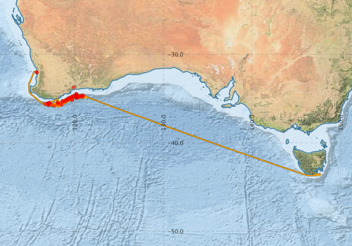
Voyage extents: 43° 41.9' S to 31° 57.2' S 114° 51.3' E to 147° 40.3' E
Marlin Metadata:-
Participants - on ship:-
| Name | Role | Organisation |
|---|---|---|
| Alex McLachlan | Science technician | ? |
| Andrea Cortese | Swath expert | ? |
| Andrew Heap | Geoscience Australia | |
| Andrew Hislop | Mechanical technician | Geoscience Australia |
| Barry Taylor | paleontologist | University of Western Australia |
| Bernadette Heaney | computing | CSIRO Oceans & Atmosphere - Hobart |
| Cameron Buchanan | Swath expert | Geoscience Australia |
| Cameron Mitchell | Geologist | Geoscience Australia |
| Colin Tindall | Science technician | ? |
| Ed Chudyk | Deputy leader/geophysicist | Geoscience Australia |
| Georgina Burch | Geologist/seismic processor | Geoscience Australia |
| Jane Blevin | Geologist | CSIRO Oceans & Atmosphere - Hobart |
| Jim Whatman | Electronics technician | ? |
| Lindsay Pender | computing | CSIRO Oceans & Atmosphere - Hobart |
| Mike Sexton | Geologist/seismic processor | Geoscience Australia |
| Neville Exon | Chief Investigator | Geoscience Australia |
| Robin O'Leary | Geologist | Geoscience Australia |
| Roger Hocking | Geologist | GSWA |
| Stephen Thomas | electronics (voyage manager) | CSIRO Oceans & Atmosphere - Hobart |
This list includes those that may have only been on part of the voyage. See voyage reports on 'Reports and Maps' tab for details.
Marine National Facility Reports - plans, summaries and data processing
-
SS200403 Voyage Plan
- includes objectives, investigator details, proposed data collection, voyage track and equipment to be used.
-
SS200403 Underway Data Processing Report
- details of data processing steps, calibration information, instruments used and any issues with the data.
-
SS200403 Voyage Summary
- includes preliminary results, voyage narrative, types of data collected with C77/ROSCOP codes.
-

Publications, reports and datasets from this voyage.
Movie
- Harris, P.T., Heap, A.D., Post, A. (2007) The Carpentaria Reefs: A New Coral Reef Province for Australia. Geoscience Australia, Canberra. External link to reference
Search for publications, reports and datasets from this and other voyages
Data publishing
This is a list of online datasets hosted by CSIRO. Other processed datasets hosted by collaborating organisations may be found on the 'Metadata' or "Reports, Publications and Maps' tab.
Use the Get data link on the right to extract data using the NCMI Data Trawler.
| Data Stream | Data Summary | Get data | ||||||||||||||
|---|---|---|---|---|---|---|---|---|---|---|---|---|---|---|---|---|
| ADCP Data |
|
Get Data from Trawler Download dataset 7.8 / 1.7 Mb Processing report for this dataset |
||||||||||||||
| Multibeam echosounder |
|
Get Data from Trawler |
||||||||||||||
| Underway |
|
Get Data from Trawler |
Deployments by start time:- Click on column header to sort. Use link on 'Deployment' to see full details. Use the CSV button at the bottom to export data (tab delimited).
Search for deployments from this voyage and others
| Deployment | Operation | Station | Cast | Gear | Project | Start and end times | Start Location | End Location | Depth range | Max Depth | Description | |||
|---|---|---|---|---|---|---|---|---|---|---|---|---|---|---|
| Multibeam echosounder [details] | EM300 Multibeam Echosounder | 2004-02-09 03:05 | 2004-03-09 19:54 | -32.0517 | 115.7426 | -43.2777 | 147.2508 | 6846.3 | ||||||
| Underway System [details] | Air Temperature Sensor-HMP233,Barometer,Fluorometer WS3S-026,GPS-Generic SS-NF,Gyro-Generic SS-NF,Humidity Sensor-HMP233,Licor-UWQ 3708,RM Young 05103 wind monitor,RM Young 05103 wind monitor,RM Young 05103 wind monitor,Seapath 200,Simrad EA500 Echosounder,ThermoSalinoGraph (TSG)-SS-SN 1777,ThermoSalinoGraph (TSG)-SS-SN 1777 | 142 | 2004-02-09 03:28 | 2004-03-09 19:37 | -32.0289 | 115.6948 | -43.3151 | 147.1971 | ||||||
| ADCP Data [details] | RDI VM-150 Acoustic Doppler current profiler | 142 | 2004-02-10 18:20 | 2004-03-09 18:20 | -35.8360 | 117.6890 | -43.4980 | 147.1140 | 400.8 | |||||
| Sediment Sampling [details] | 265/01DR01 | 142 | 2004-02-11 00:00 | -35.6425 | 118.1172 | |||||||||
| Sediment Sampling [details] | 265/03DR03 | 142 | 2004-02-16 00:00 | -35.4783 | 118.0600 | |||||||||
| Sediment Sampling [details] | 265/04DR04 | 142 | 2004-02-16 00:00 | -35.4892 | 118.0950 | |||||||||
| Sediment Sampling [details] | 265/05DR05 | 142 | 2004-02-18 00:00 | -35.6033 | 116.6667 | |||||||||
| Sediment Sampling [details] | 265/06DR06 | 142 | 2004-02-24 00:00 | -35.4783 | 117.1533 | |||||||||
| Sediment Sampling [details] | 265/07DR07 | 142 | 2004-02-25 00:00 | -35.4833 | 117.1683 | |||||||||
| Sediment Sampling [details] | 265/08DR08 | 142 | 2004-02-25 00:00 | -35.5542 | 117.0050 | |||||||||
| Sediment Sampling [details] | 265/10DR10 | 142 | 2004-02-25 00:00 | -35.7167 | 117.0083 | |||||||||
| Sediment Sampling [details] | 265/09DR09 | 142 | 2004-02-25 00:00 | -35.5567 | 116.9433 | |||||||||
| Sediment Sampling [details] | 265/11DR11 | 142 | 2004-02-26 00:00 | -35.7017 | 117.0383 | |||||||||
| Sediment Sampling [details] | 265/12DR12 | 142 | 2004-02-26 00:00 | -35.6967 | 117.3233 | |||||||||
| Sediment Sampling [details] | 265/14DR14 | 142 | 2004-02-26 00:00 | -35.5458 | 118.4550 | |||||||||
| Sediment Sampling [details] | 265/13DR13 | 142 | 2004-02-26 00:00 | -35.7283 | 118.5100 | |||||||||
| Sediment Sampling [details] | 265/16DR16 | 142 | 2004-02-27 00:00 | -35.3125 | 118.6475 | |||||||||
| Sediment Sampling [details] | 265/19DR19 | 142 | 2004-02-27 00:00 | -35.1479 | 119.0567 | |||||||||
| Sediment Sampling [details] | 265/18DR18 | 142 | 2004-02-27 00:00 | -35.2983 | 118.8958 | |||||||||
| Sediment Sampling [details] | 265/17DR17 | 142 | 2004-02-27 00:00 | -35.3408 | 118.8750 | |||||||||
| Sediment Sampling [details] | 265/15DR15 | 142 | 2004-02-27 00:00 | -35.2950 | 118.6125 | |||||||||
| Sediment Sampling [details] | 265/25DR25 | 142 | 2004-02-28 00:00 | -35.1692 | 119.6967 | |||||||||
| Sediment Sampling [details] | 265/26DR26 | 142 | 2004-02-28 00:00 | -35.1256 | 119.6923 | |||||||||
| Sediment Sampling [details] | 265/23DR23 | 142 | 2004-02-28 00:00 | -34.9617 | 119.3242 | |||||||||
| Sediment Sampling [details] | 265/22DR22 | 142 | 2004-02-28 00:00 | -35.0658 | 119.2850 | |||||||||
| Sediment Sampling [details] | 265/20DR20 | 142 | 2004-02-28 00:00 | -35.1917 | 119.0933 | |||||||||
| Sediment Sampling [details] | 265/24DR24 | 142 | 2004-02-28 00:00 | -34.9650 | 119.3767 | |||||||||
| Sediment Sampling [details] | 265/21DR21 | 142 | 2004-02-28 00:00 | -35.0950 | 119.2075 | |||||||||
| Sediment Sampling [details] | 265/27DR27 | 142 | 2004-02-29 00:00 | -34.8725 | 119.5450 | |||||||||
| Sediment Sampling [details] | 265/28DR28 | 142 | 2004-02-29 00:00 | -34.8425 | 119.6075 | |||||||||
| Sediment Sampling [details] | 265/31DR31 | 142 | 2004-02-29 00:00 | -34.7542 | 119.7917 | |||||||||
| Sediment Sampling [details] | 265/30DR30 | 142 | 2004-02-29 00:00 | -34.7875 | 119.8733 | |||||||||
| Sediment Sampling [details] | 265/29DR29 | 142 | 2004-02-29 00:00 | -34.8142 | 119.7650 | |||||||||
| Sediment Sampling [details] | 265/33DR33 | 142 | 2004-03-01 00:00 | -34.7200 | 120.0167 | |||||||||
| Sediment Sampling [details] | 265/32DR32 | 142 | 2004-03-01 00:00 | -33.7231 | 119.8690 | |||||||||
| Sediment Sampling [details] | 265/34DR34 | 142 | 2004-03-01 00:00 | -34.6867 | 119.9450 | |||||||||
| Sediment Sampling [details] | 265/47DR35 | 142 | 2004-03-02 00:00 | -34.8158 | 120.2043 | |||||||||
| Sediment Sampling [details] | 265/52DR40 | 142 | 2004-03-03 00:00 | -34.7083 | 120.5442 | |||||||||
| Sediment Sampling [details] | 265/49DR37 | 142 | 2004-03-03 00:00 | -34.6733 | 120.2083 | |||||||||
| Sediment Sampling [details] | 265/50DR38 | 142 | 2004-03-03 00:00 | -34.6733 | 120.2092 | |||||||||
| Sediment Sampling [details] | 265/51DR39 | 142 | 2004-03-03 00:00 | -34.6402 | 120.1957 | |||||||||
| Sediment Sampling [details] | 265/53DR41 | 142 | 2004-03-03 00:00 | -34.7833 | 120.4700 | |||||||||
| Sediment Sampling [details] | 265/53DR41 | 142 | 2004-03-03 00:00 | -34.7633 | 120.5367 | |||||||||
| Sediment Sampling [details] | 265/48DR36 | 142 | 2004-03-03 00:00 | -34.7083 | 120.2292 | |||||||||
| Sediment Sampling [details] | 265/56DR44 | 142 | 2004-03-04 00:00 | -34.7458 | 120.9083 | |||||||||
| Sediment Sampling [details] | 265/55DR43 | 142 | 2004-03-04 00:00 | -34.7800 | 120.8100 | |||||||||
| Sediment Sampling [details] | 265/37GR03 | 142 | -34.5745 | 120.1775 | ||||||||||
| Sediment Sampling [details] | 265/40GC04 | 142 | -34.6691 | 120.1797 | ||||||||||
| Sediment Sampling [details] | 265/41GC05 | 142 | -34.7126 | 120.1617 | ||||||||||
| Sediment Sampling [details] | 265/36GR02 | 142 | -34.4943 | 120.1778 | ||||||||||
| Sediment Sampling [details] | 265/35GR01 | 142 | -34.4943 | 120.1778 | ||||||||||
| Sediment Sampling [details] | 265/45GC09 | 142 | -34.8932 | 120.1774 | ||||||||||
| Sediment Sampling [details] | 265/58GC11 | 142 | -34.6591 | 120.8272 | ||||||||||
| Sediment Sampling [details] | 265/39GC03 | 142 | -34.6608 | 120.1142 | ||||||||||
| Sediment Sampling [details] | 265/59GC12 | 142 | -34.6573 | 120.9548 | ||||||||||
| Sediment Sampling [details] | 265/42GC06 | 142 | -34.7612 | 120.1777 | ||||||||||
| Sediment Sampling [details] | 265/38GC02 | 142 | -34.6067 | 120.1783 | ||||||||||
| Sediment Sampling [details] | 265/37GC01 | 142 | -34.5750 | 120.1772 | ||||||||||
| Sediment Sampling [details] | 265/46GC10 | 142 | -34.9465 | 120.2815 | ||||||||||
| Sediment Sampling [details] | 265/44GC08 | 142 | -34.8432 | 120.1777 | ||||||||||