Voyage details and related metadata, reports, events and data.
SS 03/2003
(alternative identifier: SS200303)
- is a Marine National Facility ![]() voyage
voyage
Period: 2003-04-11 22:00 to 2003-04-26 02:00 UTC
Duration: 14.17 days
From: Brisbane To: Cairns
Region: East Australian Coastal waters between Brisbane and Cairns
Ship: Southern Surveyor [details]
Description:
To study A New Mechanism for Supply of Sand to Deep Water:
The Eastern Australian Longshore Transport System.
Leader: Prof R. Boyd (Uni of Newcastle)
Project: National Facility External Users: R. Boyd (University of Newcastle) [details]
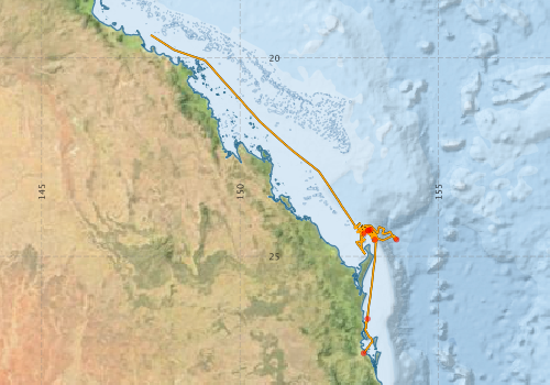
Voyage extents: 27° 26.4' S to 19° 25.4' S 147° 44.9' E to 153° 56.9' E Get voyage track shapefile Get CSV
Marlin Metadata:-
Participants - on ship:-
| Name | Role | Organisation |
|---|---|---|
| Bernadette Heaney | Computing | CSIRO Oceans & Atmosphere - Hobart |
| David Mitchell | Technician | University of Sydney |
| Gary Critchley | Hydrochemistry | CSIRO Oceans & Atmosphere - Hobart |
| Jason Roberts | Research Student | University of Newcastle - Depart. of Geology |
| Jonathon Beaudoin | Research Student | OMG, University of New Brunswick |
| Kevin Hooper | Technician | James Cook University - Department of Marine Biology |
| Kevin Ruming | Research Scientist | University of Newcastle - Depart. of Geology |
| Mark Underwood | Electronics | CSIRO Oceans & Atmosphere - Hobart |
| Ron Boyd | Chief Investigator | University of Newcastle - Depart. of Geology |
| Ron Plaschke | Voyage Manager | CSIRO Oceans & Atmosphere - Hobart |
| Shannon Davies | Research Student | University of Newcastle - Depart. of Geology |
| Tobi Payenberg | Research Scientist | NCPGG |
This list includes those that may have only been on part of the voyage. See voyage reports on 'Reports and Maps' tab for details.
Marine National Facility Reports - plans, summaries and data processing
-
SS200303 Voyage Plan
- includes objectives, investigator details, proposed data collection, voyage track and equipment to be used.
-
SS200303 Underway Data Processing Report
- details of data processing steps, calibration information, instruments used and any issues with the data.
-
SS200303 Voyage Summary
- includes preliminary results, voyage narrative, types of data collected with C77/ROSCOP codes.
-

Search for publications, reports and datasets from this and other voyages
Data publishing
This is a list of online datasets hosted by CSIRO. Other processed datasets hosted by collaborating organisations may be found on the 'Metadata' or "Reports, Publications and Maps' tab.
Use the Get data link on the right to extract data using the NCMI Data Trawler.
| Data Stream | Data Summary | Get data | ||||||||||||||
|---|---|---|---|---|---|---|---|---|---|---|---|---|---|---|---|---|
| ADCP Data |
|
Get Data from Trawler Download dataset 2.4/0.4 Gb Processing report for this dataset |
||||||||||||||
| CTD profile |
|
Get Data from Trawler Download CSV dataset 470 / 46 Kb Download ascii dataset 200/36 Kb Processing Report for this dataset Download netCDF dataset 72/30 Kb |
||||||||||||||
| Multibeam echosounder | No data | |||||||||||||||
| Underway |
|
Get Data from Trawler |
Deployments by start time:- Click on column header to sort. Use link on 'Deployment' to see full details. Use the CSV button at the bottom to export data (tab delimited).
Search for deployments from this voyage and others
| Deployment | Operation | Station | Cast | Gear | Project | Start and end times | Start Location | End Location | Depth range | Max Depth | Description | |||
|---|---|---|---|---|---|---|---|---|---|---|---|---|---|---|
| Underway System [details] | Air Temperature Sensor-HMP233,Barometer,Fluorometer WS3S-443P,GPS-Generic SS-NF,GPS-Generic SS-NF,Humidity Sensor-HMP233,Licor-UWQ 3708,RM Young 05103 wind monitor,RM Young 05103 wind monitor,RM Young 05103 wind monitor,Simrad EA500 Echosounder,ThermoSalinoGraph (TSG)-SS-SN 1777,ThermoSalinoGraph (TSG)-SS-SN 1777 | 134 | 2003-04-11 22:25 | 2003-04-24 20:54 | -27.4402 | 153.1119 | -19.4226 | 147.7486 | ||||||
| ADCP Data [details] | RDI VM-150 Acoustic Doppler current profiler | 134 | 2003-04-12 08:40 | 2003-04-14 16:20 | -26.5740 | 153.2120 | -24.4830 | 153.0400 | 208.4 | |||||
| CTD Cast [details] | 1 | Cast 1 | CTD 19,Conductivity CTD 19-SN 2598,Pressure CTD 19-SN 75637,Temperature CTD 19-SN 2334 | 134 | 2003-04-12 20:11 | 2003-04-12 20:17 | -24.5795 | 153.3948 | 46 | |||||
| CTD Cast [details] | 1 | Cast 2 | CTD 19,Conductivity CTD 19-SN 2598,Pressure CTD 19-SN 75637,Temperature CTD 19-SN 2334 | 134 | 2003-04-14 03:05 | 2003-04-14 03:39 | -24.3260 | 153.2864 | -24.3265 | 153.2835 | 670 | |||
| CTD Cast [details] | 1 | Cast 3 | CTD 19,Conductivity CTD 19-SN 2598,Pressure CTD 19-SN 75637,Temperature CTD 19-SN 2334 | 134 | 2003-04-15 08:46 | 2003-04-15 08:52 | -24.4188 | 153.1263 | 24 | |||||
| CTD Cast [details] | 1 | Cast 4 | CTD 19,Conductivity CTD 19-SN 2598,Pressure CTD 19-SN 75637,Temperature CTD 19-SN 2334 | 134 | 2003-04-16 15:13 | 2003-04-16 17:40 | -24.5777 | 153.9426 | -24.5988 | 153.9194 | 3642 | |||
| CTD Cast [details] | 1 | Cast 5 | CTD 19,Conductivity CTD 19-SN 2598,Pressure CTD 19-SN 75637,Temperature CTD 19-SN 2334 | 134 | 2003-04-21 09:07 | 2003-04-21 09:21 | -24.3453 | 153.2278 | -24.3420 | 153.2251 | 196 | |||
| CTD Cast [details] | 1 | Cast 6 | CTD 19,Conductivity CTD 19-SN 2598,Pressure CTD 19-SN 75637,Temperature CTD 19-SN 2334 | 134 | 2003-04-22 05:33 | 2003-04-22 05:47 | -24.3507 | 153.2282 | -24.3501 | 153.2270 | 192 | |||