Survey details and related metadata, reports, events and data.
SS 07/93 (alternative identifier: SS199307)
Period: 1993-10-27 00:00 to 1993-11-28 00:00 UTC
Duration: 32.00 days
From: Darwin To: Cairns
Region: Gulf of Carpentaria, Northern Queensland
Ship: Southern Surveyor [details]
Description:
Southern Surveyor cruise SS 07/93 was undertaken to test devices for the Bycatch Reduction in Prawn Trawls project in the area of the tiger prawn fishery west of Weipa, Gulf of Carpentaria; to conduct the commercial fish biomass survey with the Frank and Bryce net in the northern half of the GOC as in previous cruise SS 01/93 and to continue the EFN (environmentally friendly net) trials initiated on Leg 2 of cruise SS 01/93.
Cruise objectives include to investigate the efficiency of the EFN in areas with bottom structure; to investigate fish habitats by characterising the benthic flora and fauna at each site; to obtain video images of the EFN, bottom structure and fish behaviour; to collect tissue samples from L. malabaricus and L. sebae for the genetics group in Hobart; to collect fish samples for the I. S. R. Munro Fish Collection in Hobart; to collect leiognathids for J. Smith and Queensland museum staff to collect sponges during the trawls.
Leader: J. Salini (CSIRO)
Project: The fish resources of tropical north-eastern Australian waters (FIRDC project no. 88/77) 1989-1992 [details]
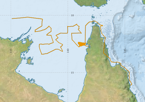
Voyage extents: 16° 08.5' S to 10° 09.4' S 135° 05.9' E to 145° 36.5' E Get voyage track shapefile Get CSV
Marlin Metadata:-
Metadata from OBIS Australia datasets:- biological data is published via the OBIS-AU IPT server and delivered to one or more of OBIS, ALA and GBIF
Download from OBIS Australia IPT View at - Ocean Biodiversity Information System (OBIS) Atlas of Living Australia (ALA) GBIF
Participants - on ship:-
| Name | Leg | Role | Organisation |
|---|---|---|---|
| Carlos Souris | 2 | CSIRO Fisheries | |
| Clive Liron | 1 | CSIRO Fisheries | |
| David Brewer | 1 2 | CSIRO Fisheries | |
| Gordon Yearsley | 2 | CSIRO Fisheries | |
| Graham Baulach | 1 | NT Fisheries | |
| Jeff Cordell | 1 | CSIRO Fisheries | |
| John Kennedy | 1 | Q museum | |
| John Salini | 1 2 | Cruise leader | CSIRO Fisheries |
| Jonthan Staunton Smith | 1 | CSIRO Fisheries | |
| Lindsay MacDonald | 2 | CSIRO Fisheries | |
| Marcus Strauss | 1 2 | AMC | |
| Margaret Farmer | 2 | CSIRO Fisheries | |
| Nevile Gill | 2 | NT Fisheries | |
| Nick Elliot | 1 | CSIRO Fisheries | |
| Pat Graham | 2 | CSIRO Fisheries | |
| Richard Mounsey | 1 | NT Fisheries | |
| Stephanie Boubaris | 2 | NT Fisheries | |
| Steve Cook | 1 | Q museum | |
| Steve Eayrs | 1 2 | AMC | |
| Yougan Wang | 2 | CSIRO Fisheries |
This list includes those that may have only been on part of the voyage. See voyage reports on 'Reports and Maps' tab for details.
Marine National Facility Reports - plans, summaries and data processing
-
SS199307 Voyage Summary
- includes preliminary results, voyage narrative, types of data collected with C77/ROSCOP codes.
-
SS199307 Voyage Plan
- includes objectives, investigator details, proposed data collection, voyage track and equipment to be used.
-

Publications, reports and datasets from this voyage.
Dataset
- Appleyard, Sharon; Ward, Robert; Pogonoski, John; Graham, Alastair; Last, Peter; Deagle, Bruce; & Holmes, Bronwyn (2024): Marine fishes (from Australia) COI barcode reference library. v2. CSIRO. Data Collection. 10.25919/8haz-aa91
IPT Resource
- Australian National Fish Collection (ANFC) (Darwin Core Archive) External link to reference
Journal Article
- SU, YO,LIN, HSIU-CHIN,HO, HSUAN-CHING (2022) A new cryptic species of the pineapple fish genus Monocentris (Family Monocentridae) from the western Pacific Ocean, with redescription of M. japonica (Houttuyn, 1782). Zootaxa 5189 pp180-203. 10.11646/zootaxa.5189.1.18
- Staunton-Smith, J.,Blaber, S. J. M.,Greenwood, J. G. (1999) Interspecific differences in the distribution of adult and juvenile ponyfish (Leiognathidae) in the Gulf of Carpentaria, Australia. Marine and Freshwater Research 50 pp643-. 10.1071/MF99007
Search for publications, reports and datasets from this and other voyages
Data publishing
This is a list of online datasets hosted by CSIRO. Other processed datasets hosted by collaborating organisations may be found on the 'Metadata' or "Reports, Publications and Maps' tab.
Use the Get data link on the right to extract data using the NCMI Data Trawler.
| Data Stream | Data Summary | Get data | ||||||||||||
|---|---|---|---|---|---|---|---|---|---|---|---|---|---|---|
| Marine biodiversity observations and/or samples |
|
Get Data from Trawler |
Deployments by start time:- Click on column header to sort. Use link on 'Deployment' to see full details. Use the CSV button at the bottom to export data (tab delimited).
Search for deployments from this voyage and others
| Deployment | Operation | Station | Cast | Gear | Project | Start and end times | Start Location | End Location | Depth range | Max Depth | Description | |||
|---|---|---|---|---|---|---|---|---|---|---|---|---|---|---|
| Underway System [details] | Doppler speed log,Licor-UWQ 3708,RM Young 05103 wind monitor,RM Young 05103 wind monitor,Simrad EK500 echosounder,Sperry gyrocompass,Temperature sensor-41342,ThermoSalinoGraph (TSG)-SS-SN 1777,ThermoSalinoGraph (TSG)-SS-SN 1777 | |||||||||||||