Survey details and related metadata, reports, events and data.
Halmahera Sea Mooring (1993) (alternative identifier: M-HALMA93)
Period: 1993-06-29 00:00 to 1994-07-07 00:00 Local
Duration: 373.00 days
Mooring: Halmahera Sea Mooring (1993) [details]
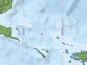
Description: The Halmahera Sea mooring forms part of the ASEAN-Australia Regional Ocean Dynamics Expedition (1993) study, a project involving six nations led by Dr George Cresswell. One mooring was installed in a water depth of 950 metres. It was deployed from the Indonesian research vessel Baruna Jaya 1 in June 1993 and recovered in July 1994.
Leader: G. Cresswell (CSIRO)
Project: Regional Oceanographic Studies (+ successors) 1981-1997 [details]
Map extents: 50° 00.0' S to 0° 00.0' N 95° 00.0' E to 180° 00.0' E
Marlin Metadata:-
Participants:- no records
Marine National Facility Reports - plans, summaries and data processing
- There is no map for this survey.
Search for publications, reports and datasets from this and other voyages
Data publishing
This is a list of online datasets hosted by CSIRO. Other processed datasets hosted by collaborating organisations may be found on the 'Metadata' or "Reports, Publications and Maps' tab.
Use the Get data link on the right to extract data using the NCMI Data Trawler.
| Data Stream | Data Summary | Get data | ||||||||||||||
|---|---|---|---|---|---|---|---|---|---|---|---|---|---|---|---|---|
| Current Meter records from Moorings |
|
Get Data from Trawler |
Deployments by start time:- Click on column header to sort. Use link on 'Deployment' to see full details. Use the CSV button at the bottom to export data (tab delimited).
Search for deployments from this voyage and others
| Deployment | Operation | Station | Cast | Gear | Project | Start and end times | Start Location | End Location | Depth range | Max Depth | Description | |||
|---|---|---|---|---|---|---|---|---|---|---|---|---|---|---|
| Current Meter [details] | 1 | 1523 | 1993-06-29 00:00 | 1994-07-07 00:00 | 0.3950 | 129.4717 | 0 | 465 | ||||||
| Current Meter [details] | 1 | 1523 | 1993-06-29 00:00 | 1994-07-07 00:00 | 0.3950 | 129.4717 | 0 | 467 | ||||||
| Current Meter [details] | 1 | 1523 | 1993-06-29 00:00 | 1994-07-07 00:00 | 0.3950 | 129.4717 | 0 | 469 | ||||||
| Current Meter [details] | 2 | 1523 | 1993-06-29 00:00 | 1994-07-07 00:00 | 0.3950 | 129.4717 | 0 | 468 | ||||||
| Current Meter [details] | 2 | 1523 | 1993-06-29 00:00 | 1994-07-07 00:00 | 0.3950 | 129.4717 | 0 | 470 | ||||||
| Current Meter [details] | 2 | 1523 | 1993-06-29 00:00 | 1994-07-07 00:00 | 0.3950 | 129.4717 | 0 | 466 | ||||||