Survey details and related metadata, reports, events and data.
Evans Head Upwelling Moorings (1989) (alternative identifier: M-EH89)
Period: 1989-09-04 00:00 to 1990-03-21 00:00 Local
Duration: 198.00 days
Mooring: Evans Head Upwelling Moorings (1989) [details]
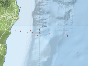
Description: As part of a study of ocean transport in the Tasman Sea, a transect of 8 (?) moorings was deployed at approximately 29 deg S to approximately 100 km offshore from Evans Head, between August 1989 and March 1990. The moorings were deployed during Franklin voyage FR 10/89-11/89 and recovered during voyage 03/90.
Leader: G. Cresswell (CSIRO)
Project: Regional Oceanographic Studies (+ successors) 1981-1997 [details]
Map extents: 50° 00.0' S to 0° 00.0' N 95° 00.0' E to 180° 00.0' E
Marlin Metadata:-
Participants:- no records
Marine National Facility Reports - plans, summaries and data processing
- There is no map for this survey.
Search for publications, reports and datasets from this and other voyages
Data publishing
This is a list of online datasets hosted by CSIRO. Other processed datasets hosted by collaborating organisations may be found on the 'Metadata' or "Reports, Publications and Maps' tab.
Use the Get data link on the right to extract data using the NCMI Data Trawler.
| Data Stream | Data Summary | Get data | ||||||||||||||
|---|---|---|---|---|---|---|---|---|---|---|---|---|---|---|---|---|
| Current Meter records from Moorings |
|
Get Data from Trawler |
Deployments by start time:- Click on column header to sort. Use link on 'Deployment' to see full details. Use the CSV button at the bottom to export data (tab delimited).
Search for deployments from this voyage and others
| Deployment | Operation | Station | Cast | Gear | Project | Start and end times | Start Location | End Location | Depth range | Max Depth | Description | |||
|---|---|---|---|---|---|---|---|---|---|---|---|---|---|---|
| Current Meter [details] | 1 | 1523 | 1989-09-04 00:00 | 1990-03-21 00:00 | -29.1267 | 153.8683 | 0 | 274 | ||||||
| Current Meter [details] | 1 | 1523 | 1989-09-04 00:00 | 1989-12-27 00:00 | -29.1933 | 154.5417 | 0 | 286 | ||||||
| Current Meter [details] | 1 | 1523 | 1989-09-04 00:00 | 1990-02-10 00:00 | -29.0900 | 153.5400 | 0 | 258 | ||||||
| Current Meter [details] | 1 | 1523 | 1989-09-04 00:00 | 1990-03-21 00:00 | -29.1517 | 154.1850 | 0 | 284 | ||||||
| Current Meter [details] | 1 | 1523 | 1989-09-04 00:00 | 1990-03-21 00:00 | -29.1267 | 153.8683 | 0 | 272 | ||||||
| Current Meter [details] | 1 | 1523 | 1989-09-04 00:00 | 1990-03-21 00:00 | -29.1517 | 154.1850 | 0 | 282 | ||||||
| Current Meter [details] | 1 | 1523 | 1989-09-04 00:00 | 1989-12-08 00:00 | -29.1850 | 153.9550 | 0 | 276 | ||||||
| Current Meter [details] | 1 | 1523 | 1989-09-04 00:00 | 1990-03-21 00:00 | -29.1850 | 153.9550 | 0 | 280 | ||||||
| Current Meter [details] | 1 | 1523 | 1989-09-04 00:00 | 1990-03-21 00:00 | -29.1267 | 153.8683 | 0 | 270 | ||||||
| Current Meter [details] | 1 | 1523 | 1989-09-04 00:00 | 1990-03-21 00:00 | -29.1850 | 153.9550 | 0 | 278 | ||||||
| Current Meter [details] | 1 | 1523 | 1989-09-04 00:00 | 1990-03-02 00:00 | -29.1933 | 154.5417 | 0 | 288 | ||||||
| Current Meter [details] | 1 | 1523 | 1989-09-04 00:00 | 1990-03-21 00:00 | -29.1300 | 153.7650 | 0 | 262 | ||||||
| Current Meter [details] | 1 | 1523 | 1989-09-04 00:00 | 1990-02-06 00:00 | -29.1033 | 153.6267 | 0 | 260 | ||||||
| Current Meter [details] | 2 | 1523 | 1989-09-04 00:00 | 1989-12-27 00:00 | -29.1933 | 154.5417 | 0 | 287 | ||||||
| Current Meter [details] | 2 | 1523 | 1989-09-04 00:00 | 1990-03-21 00:00 | -29.1517 | 154.1850 | 0 | 285 | ||||||
| Current Meter [details] | 2 | 1523 | 1989-09-04 00:00 | 1990-03-21 00:00 | -29.1517 | 154.1850 | 0 | 283 | ||||||
| Current Meter [details] | 2 | 1523 | 1989-09-04 00:00 | 1990-03-21 00:00 | -29.1850 | 153.9550 | 0 | 281 | ||||||
| Current Meter [details] | 2 | 1523 | 1989-09-04 00:00 | 1990-03-21 00:00 | -29.1850 | 153.9550 | 0 | 279 | ||||||
| Current Meter [details] | 2 | 1523 | 1989-09-04 00:00 | 1989-12-08 00:00 | -29.1850 | 153.9550 | 0 | 277 | ||||||
| Current Meter [details] | 2 | 1523 | 1989-09-04 00:00 | 1990-03-21 00:00 | -29.1267 | 153.8683 | 0 | 275 | ||||||
| Current Meter [details] | 2 | 1523 | 1989-09-04 00:00 | 1990-03-21 00:00 | -29.1267 | 153.8683 | 0 | 273 | ||||||
| Current Meter [details] | 2 | 1523 | 1989-09-04 00:00 | 1990-03-21 00:00 | -29.1267 | 153.8683 | 0 | 271 | ||||||
| Current Meter [details] | 2 | 1523 | 1989-09-04 00:00 | 1990-03-21 00:00 | -29.1300 | 153.7650 | 0 | 263 | ||||||
| Current Meter [details] | 2 | 1523 | 1989-09-04 00:00 | 1990-02-06 00:00 | -29.1033 | 153.6267 | 0 | 261 | ||||||
| Current Meter [details] | 2 | 1523 | 1989-09-04 00:00 | 1990-02-10 00:00 | -29.0900 | 153.5400 | 0 | 259 | ||||||
| Current Meter [details] | 2 | 1523 | 1989-09-04 00:00 | 1990-03-02 00:00 | -29.1933 | 154.5417 | 0 | 289 | ||||||
| Current Meter [details] | 1 | 1523 | 1989-09-08 00:00 | 1990-03-21 00:00 | -29.0967 | 153.8317 | 0 | 264 | ||||||
| Current Meter [details] | 1 | 1523 | 1989-09-08 00:00 | 1990-03-21 00:00 | -29.0967 | 153.8317 | 0 | 266 | ||||||
| Current Meter [details] | 1 | 1523 | 1989-09-08 00:00 | 1990-03-19 00:00 | -29.0967 | 153.8317 | 0 | 268 | ||||||
| Current Meter [details] | 2 | 1523 | 1989-09-08 00:00 | 1990-03-21 00:00 | -29.0967 | 153.8317 | 0 | 265 | ||||||
| Current Meter [details] | 2 | 1523 | 1989-09-08 00:00 | 1990-03-21 00:00 | -29.0967 | 153.8317 | 0 | 267 | ||||||
| Current Meter [details] | 2 | 1523 | 1989-09-08 00:00 | 1990-03-19 00:00 | -29.0967 | 153.8317 | 0 | 269 | ||||||