Survey details and related metadata, reports, events and data.
Arafura Sea/Gulf of Carpentaria Moorings (1987) (alternative identifier: M-ARA-GOC87)
Period: 1987-11-19 00:00 to 1988-02-29 00:00 Local
Duration: 102.00 days
Mooring: Arafura/G. of Carpent. Moorings (1987) [details]
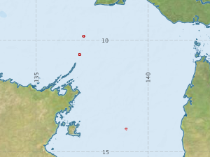
Description: Three moorings were installed in the Arafura Sea (between Arnhem Land and Papua New Guinea) and the centre of the Gulf of Carpentaria for 3 months between November 1987 and February 1988. The moorings were deployed during Franklin voyage FR 10/87 and recovered during voyage FR 02/88.
Leader: A. Forbes (CSIRO)
Project: Regional Oceanographic Studies (+ successors) 1981-1997 [details]
Map extents: 50° 00.0' S to 0° 00.0' N 95° 00.0' E to 180° 00.0' E
Marlin Metadata:-
Participants:- no records
Marine National Facility Reports - plans, summaries and data processing
- There is no map for this survey.
Search for publications, reports and datasets from this and other voyages
Data publishing
This is a list of online datasets hosted by CSIRO. Other processed datasets hosted by collaborating organisations may be found on the 'Metadata' or "Reports, Publications and Maps' tab.
Use the Get data link on the right to extract data using the NCMI Data Trawler.
| Data Stream | Data Summary | Get data | ||||||||||||||
|---|---|---|---|---|---|---|---|---|---|---|---|---|---|---|---|---|
| Current Meter records from Moorings |
|
Get Data from Trawler |
Deployments by start time:- Click on column header to sort. Use link on 'Deployment' to see full details. Use the CSV button at the bottom to export data (tab delimited).
Search for deployments from this voyage and others
| Deployment | Operation | Station | Cast | Gear | Project | Start and end times | Start Location | End Location | Depth range | Max Depth | Description | |||
|---|---|---|---|---|---|---|---|---|---|---|---|---|---|---|
| Current Meter [details] | 1 | 1523 | 1987-11-19 00:00 | 1988-02-25 00:00 | -9.8183 | 137.1233 | 0 | 198 | ||||||
| Current Meter [details] | 1 | 1523 | 1987-11-19 00:00 | 1988-02-29 00:00 | -9.8183 | 137.1233 | 0 | 196 | ||||||
| Current Meter [details] | 1 | 1523 | 1987-11-19 00:00 | 1988-02-06 00:00 | -10.6400 | 136.9417 | 0 | 190 | ||||||
| Current Meter [details] | 1 | 1523 | 1987-11-19 00:00 | 1988-02-25 00:00 | -10.6400 | 136.9417 | 0 | 188 | ||||||
| Current Meter [details] | 2 | 1523 | 1987-11-19 00:00 | 1988-02-06 00:00 | -10.6400 | 136.9417 | 0 | 191 | ||||||
| Current Meter [details] | 2 | 1523 | 1987-11-19 00:00 | 1988-02-25 00:00 | -10.6400 | 136.9417 | 0 | 189 | ||||||
| Current Meter [details] | 2 | 1523 | 1987-11-19 00:00 | 1988-02-29 00:00 | -9.8183 | 137.1233 | 0 | 197 | ||||||
| Current Meter [details] | 2 | 1523 | 1987-11-19 00:00 | 1988-02-25 00:00 | -9.8183 | 137.1233 | 0 | 199 | ||||||
| Current Meter [details] | 1 | 1523 | 1987-11-20 00:00 | 1988-01-02 00:00 | -13.9883 | 139.0267 | 0 | 192 | ||||||
| Current Meter [details] | 1 | 1523 | 1987-11-20 00:00 | 1988-02-24 00:00 | -13.9883 | 139.0267 | 0 | 194 | ||||||
| Current Meter [details] | 2 | 1523 | 1987-11-20 00:00 | 1988-01-02 00:00 | -13.9883 | 139.0267 | 0 | 193 | ||||||
| Current Meter [details] | 2 | 1523 | 1987-11-20 00:00 | 1988-02-24 00:00 | -13.9883 | 139.0267 | 0 | 195 | ||||||