Voyage details and related metadata, reports, events and data.
IN2025_V07
- is a Marine National Facility ![]() voyage
voyage
Title: SOFS Recovery
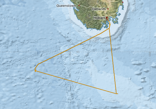
Period: 2025-07-01 00:00 to 2025-07-05 23:00 UTC
Duration: 4.96 days
From: Hobart To: Hobart
Region: Southern Ocean
Ship: Investigator (RV) [details]
Description: The primary objective is to recover the top section (surface float and instrumented wire directly below) of the SOFS-14 mooring, which was deployed on IN2025_V02 and begun drifting outside of its watch circle in May. The second priority is a recovery of the lower section of the SOFS-14 mooring, the feasibility of which will be assessed upon recovery of the surface float, and in discussion with the shore-based SOTS team. The recovery will follow the standard SOTS procedure, with required modifications depending on how much wire is attached to the underside of the float. It may be possible to do back-to-back operations (first the float, then the bottom section), but this will depend on both the weather and the fatigue of the deck crew and will be considered at sea and in consultation with the bridge and voyage management team. Should time and weather permit, there is approval for trying to complete the EM124 Backscatter Calibration at the Tasman Rise on the return to Hobart. This will require a CTD (1200m) for a full water depth velocity profile to support the calibration. 6hrs is budgeted for the work. The assessment for this shall be taken onboard, once the full extent of the mooring recovery is understood and underway.
Leader: Max McGuire
Project: SOTS: Southern Ocean Time Series automated moorings for climate and carbon cycle studies southwest of Tasmania [details] Primary
Underway data from NRUD - see this voyage
Voyage extents: 47° 38.0' S to 42° 52.9' S 142° 46.7' E to 147° 59.4' E Get voyage track shapefile Get CSV
Marlin Metadata:-
Participants - on ship:-
| Name | Role | Organisation | Project |
|---|---|---|---|
| John Hooper | Deputy Voyage Manager | Marine National Facility | Voyage Management on RV Investigator |
| Max McGuire | Voyage Manager | Marine National Facility | Voyage Management on RV Investigator |
Participants - shore based:-
| Name | Role | Organisation | Project |
|---|---|---|---|
| Elizabeth Shadwick | Chief Scientist | CSIRO Environment | SOTS: Southern Ocean Time Series automated moorings for climate and carbon cycle studies southwest of Tasmania |
This list includes those that may have only been on part of the voyage. See voyage reports on 'Reports and Maps' tab for details.
Marine National Facility Reports - plans, summaries and data processing
- View Survey map
Search for publications, reports and datasets from this and other voyages
Data publishing
This is a list of online datasets hosted by CSIRO. Other processed datasets hosted by collaborating organisations may be found on the 'Metadata' or "Reports, Publications and Maps' tab.
Use the Get data link on the right to extract data using the NCMI Data Trawler.
| Data Stream | Data Summary | Get data | ||||||||
|---|---|---|---|---|---|---|---|---|---|---|
| pCO2 |
|
External link - download datafile at IMOS Data fields and units document (.pdf) |
||||||||
| Underway |
|
Get Data from Trawler |
| ID | When (UTC) | Lat | Long | Instrument | Identifier | Action | Log | Subject / Comment |
|---|
Deployments - None have been recorded in the Data Trawler.